8 Onion Valley to Mount Whitney
SCENERY: 
TRAIL CONDITION: 
CHILDREN: 
DIFFICULTY:
SOLITUDE:
DISTANCE: 51 miles
HIKING TIME: 5–7 days
OUTSTANDING FEATURES: Gilbert Lake, Kearsarge Pass, Vidette Meadow, Forester Pass, Guitar Lake, Mount Whitney.
The final section of the John Muir Trail is not for the weak of heart, literally or figuratively. With two significant mountain passes to climb, and the conquering of the contiguous United State’s highest peak thrown in, this is where hikers earn their bragging rights. However, this 51-mile journey is not just for peak-bagging glory hounds; it also includes some of the most spectacular alpine scenery that the Sierras have to offer. Those who love their vistas wide can have their fill of expansive hiking above treeline—open meadows, stark lakes, and the cold embrace of ringing mountains nearly everywhere. Begin with a hefty 2,600-foot climb up to Kearsarge Pass (11,823 feet), where the trail descends to Vidette Meadow before it’s time to hoof it up foreboding Forester Pass (13,120 feet). Catch your breath descending to Tyndall Creek before another scenic traverse up to Guitar Lake. Lastly, conquer the inimitable Mount Whitney, a giant granite dome hulking over the Owens Valley. Like a benevolent mother, she lures the minions to join her in the heavens. That is, until you get halfway up and she begins to feel like a deceptively wicked and cruel illusionist, ever farther away. Until, finally, you reach the seeming top of the world.
DIRECTIONS: ONION VALLEY TRAILHEAD—The closest town to the Onion Valley trailhead is Independence on US 395, 16 miles north of Lone Pine and 26 miles south of Big Pine. From Independence, drive west on Market Street for 13 miles. The road name eventually changes to Onion Valley Road, and the trailhead lies at its terminus (9,180 feet).
You can take public transit as far as Independence via Inyo Mono Transit’s CREST bus, but you will need to walk or hitchhike the remaining 13 miles to the trailhead. The bus travels north on US 395 between Bishop and Reno via Mammoth Lakes on Tuesday, Thursday, and Friday, and south between Mammoth Lakes and Ridgecrest on Monday, Wednesday, and Friday. Independence lies 45 minutes south of Bishop. Rates and routes are subject to frequent change; call ahead for information and reservations at (760) 872-1901 or (800) 922-1930. More information can be found on the Web at www.countyofinyo.org/transit/CRESTpage.htm.
WHITNEY PORTAL TRAILHEAD—Whitney Portal lies 13 miles west of Lone Pine, off US 395, at the end of Whitney Portal Road. There is no public transit to the portal itself, but every car that leaves the parking lot goes through Lone Pine, so it’s fairly easy to hitch a ride.
Inyo Mono Transit’s CREST buses travel from Lone Pine south 1.5 hours to Ridgecrest and north to Bishop (1 hour) or Mammoth Lakes (2 hours). From Bishop, it’s possible to transfer to another bus farther north to Reno. Rates and routes are subject to frequent change; call ahead for information and reservations at (760) 872-1901 or (800) 922-1930. More information can be found on the Web at www.countyofinyo.org/transit/CRESTpage.htm.
| GPS coordinates | Starting trailhead ONION VALLEY | |
| UTM zone (WGS84): | 11S | |
| Easting | 0380432 | |
| Northing | 4070625 | |
| Latitude | N 36°46′25.95″ | |
| Longitude | W 118°20′23.37″ | |
| GPS Trailhead Coordinates | Ending trailhead WHITNEY PORTAL | |
| UTM zone (WGS84): | 11S | |
| Easting | 0388918 | |
| Northing | 4049743 | |
| Latitude | N 36°35′12.14″ | |
| Longitude | W 118°14′30.21″ |

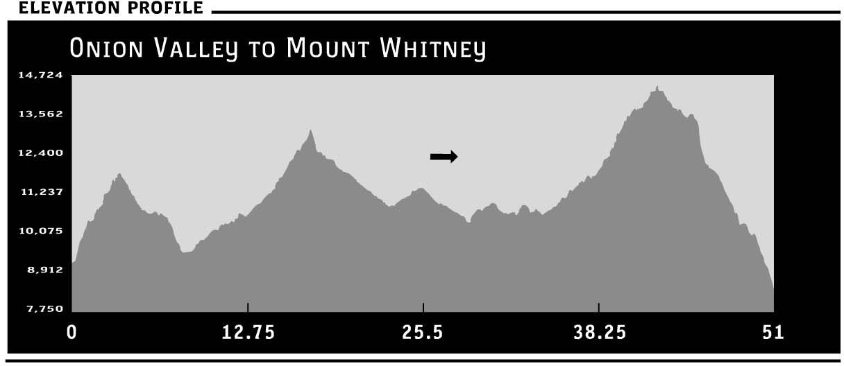
 The trail from Onion Valley starts off with a bang, with a nearly 12,000-foot pass found less than 6 miles from the start. However, the trailhead (9,185 feet) begins at such a high altitude that it’s not quite as daunting as one may fear. Begin climbing a series of manzanita-choked switchbacks to a wooded thicket. Follow babbling Independence Creek up 700 feet to Little Pothole Lake (9,900 feet). Stop and rest under the shade of willow trees before tackling the next set of switchbacks to Gilbert Lake. Traverse the lake’s northern shore on a more gradual ascent to the northern shore of shallow Flower Lake. Once again begin ascending a series of rocky switchbacks, first past lovely Heart Lake, then above the granite wall that hides Big Pothole Lake. From here, sweat up two final switchbacks to Kearsarge Pass (11,823 feet). Catch your breath and admire epic views of Kearsarge Pinnacles and Lakes.
Begin descending on a narrow, rocky trail. At the first junction, veer left to travel south on a spur trail toward Bullfrog Lake. Campsites lie 1 mile below the pass at Kearsarge Lakes (10,960 feet). Skirt the lakes’ northern shores to continue a moderate descent west toward Bullfrog Lake (10,610 feet), another reliable water source. At the next junction, turn left to join the southern route of the John Muir Trail (JMT).
Continue descending in the canyon, crossing Bullfrog Lake’s outlet, and arrive at lower Vidette Meadow (9,550 feet). Ignore the trail to Roads End, and head southeast on the JMT toward Forester Pass and upper Vidette Meadow. Enjoy a level path along the river through the shady woods of Vidette Meadow (9,600 feet), passing numerous campsites with bear boxes, before beginning a gradual to moderate forested ascent along Bubbs Creek.
Ignore the unmarked spur trail heading east to Center Basin, and continue southeast, passing more campsites, to ford Center Basin Creek. Rising out of the valley on rocky switchbacks, the view opens up tremendously en route to Forester Pass. Hitting the 11,000-foot mark, enjoy a gradual plateau with magnificent views of the snowy spires and sheer granite cliffs surrounding the rocky rubble.
Continue climbing up nicely graded switchbacks, as a stream tumbles over small boulders and tundralike grass. Just above 12,000 feet there is a glittering tarn below the distinctive jagged spire of Junction Peak. From here, continue ascending the impressive stone bridge notched into the side of the mountain supporting the trail. There is little apparent life this high, but it’s possible to spot the occasional bird, marmot, and renegade wild currants thriving in the thin air. The route winds beneath a ridgeline (don’t be deceived that this is the pass!) before ending with a series of tight, steep switchbacks to a narrow windswept niche.
Forester Pass (13,120 feet) straddles the boundary between Kings Canyon and Sequoia national parks. Officially, Forester Pass is considered the highest pass on the JMT. This is because the summit of Mount Whitney, the trail’s technical terminus, is not a pass. However, these are just technicalities, because you must traverse Trail Crest (13,656 feet) to descend to Whitney Portal. However, by all accounts, Forester is an impressively high perch from which to admire the sweeping views below.
Descend on one of the most cleverly engineered paths of the JMT. Twisty curves bend and wrap around near-impossible geography to create grades that even sore knees can appreciate. Wind down this structurally incredible labyrinth of serpentine switchbacks until they gradually give way to fast walking on a moderate descent toward the timberline. Pass gorgeous tarns and boulder fields with plenty of accessible water.
Just past the junction for Lake South America, descend again and arrive at bear boxes and campsites that boast stunning sunset alpenglow on the western mountains next to rushing Tyndall Creek (10,890 feet). After fording the river, pass the trail to the Tyndall Creek Ranger Station, and shortly thereafter come to a spur trail leading to Shepherd Pass. Ignore this and follow the first signpost to Mount Whitney, 16.1 miles ahead. Begin a short but steep climb. Cross the outlet to Tyndall Frog Ponds to find more tent sites and a bear box. Continue up- and downhill through shade and open ridge, gradually rising into Bighorn Plateau. Enjoy epic views of Tawny Point to the east and a desolate lake on your left. Remember this lake, as it’s possible to view it from the final stretch of trail toward Mount Whitney. Begin descending again through woodland toward Wallace Creek.
Cross Wright Creek and continue rising and descending toward Wallace Creek and the junction with the High Sierra Trail (10,405 feet). Use caution fording Wallace Creek. There are bear boxes and campsites on the right. Ascend 500 feet through forested benches, until the trail levels out at Sandy Meadow. Continue a pleasantly flattish route along a forested ridge before climbing over a ridge and dropping down through wooded thicket to the junction with a trail to Crabtree Meadow (10,880 feet). This is where the Pacific Crest Trail (PCT) and JMT part ways for the final time. The PCT continues heading south toward its terminus in Mexico, while the JMT turns left to head east toward Mount Whitney.
After a little less than a mile through shady conifers, come to a second junction (10,640 feet) with a trail to nearby Crabtree Ranger Station. At the signpost, look for a plastic bin with waste-disposal “pack it out” kits for those continuing to Guitar Lake and the Whitney Zone. These glamorous “wag bags” come with toilet paper, hand sanitizer, and deodorant gel. In recent years the composting toilets en route from Whitney Portal cannot keep up with the number of hikers. In 2006, more than 30,000 people camped in the Whitney Zone. As a result, the forest service is asking all backpackers to pick up the provided wag bags and pack out all their trash. There are disposal bins at Whitney Portal upon arrival at the trailhead.
Wag bag securely stashed, climb gradually for 1.5 miles to photogenic Timberline Lake (11,070 feet), where Mount Whitney’s southwestern flank is reflected in her glassy waters, making even amateur photographers feel like Ansel Adams. There is no camping at this lake.
Walk the lake’s northern shore to begin the final climb up to Guitar Lake. The climb is a bit deceiving, seemingly always on the next rocky bench, despite being less than 2 miles from Timberline Lake. Traverse a lovely alpine meadow while mountains rise up to embrace you as you head skyward. You can’t actually see Mount Whitney from Guitar Lake (11,450 feet). Camping is forbidden in the grassy areas of the lake, but there are several campsites around the neck of the guitar. Simply follow the use trail southwest for these tent sites with outstanding sunset views. Beware the hungry and clever marmot, as you will undoubtedly want food on your journey up Whitney!
Ascend to the next bench, passing the mirror ponds above Guitar Lake with limited camping. This is the last spot to pump water before the summit. Begin switchbacking up the west side of Whitney, huffing and puffing the nearly 2 miles from Guitar Lake to Trail Junction (13,484 feet), where the eastern trail from Whitney Portal meets the JMT. Foot traffic increases here as hordes of day hikers, in varying degrees of fitness and distress, summit Mount Whitney as well.
A handful of waterless campsites can be found just northwest of Trail Junction. Look for a small use trail leading to small tent sites surrounded by small rocks that create a wind shelter. While dry (and high!) these campsites are one of the world’s best spots for sunset photography, and they provide an excellent point from which to get an early start on the summit. Many hikers rise and start walking in the dark to enjoy sunrise on the summit.
If you’re not camping here, this is still the best place to shed your pack and lighten your load for the final climb. Be sure, however, not to leave any food that invites marauding animals to chew through your pack. While it’s just shy of 2 miles to the top, with only about 1,000 feet of climbing at a moderate to gentle grade, the thin air makes the journey quite taxing. Be sure to bring food, water, and extra layers. And, of course, your camera!
Begin walking the rocky ridgeline, enjoying westward views to Mounts Hale and Young and beyond, and the pointed spire of Mount Muir to the east. Look for the unnamed lake in Bighorn Plateau that you passed nearly 12 miles ago. Rocky spires and narrow ledges provide endless photo opportunities. The climb can be a bit vertigo-inducing for some, so take it easy and admire the jagged landscape of stony outcroppings, narrow windows with views to Owens Valley, and asymmetrical rocks balanced in a seemingly precarious fashion on impossible ledges.
Round the corner around Keeler Needle, and begin the final ascent to the top of Mount Whitney (14,497 feet). Approaching the summit’s broad plateau, it can be easy to lose the trail among the rocks. Watch for cairns until the tin-roofed shelter at the top comes into view. The shelter is a welcome spot during high winds, but do not seek protection here during a storm, as the tin roof is a lightning conductor. Hikers have died here in the past.
For JMT thru-hikers, this marks the completion of their task, as oddly enough the top of Whitney also marks the official end of the John Muir Trail. Even purists, however, manage to descend the trail eventually.
The mountain was christened Whitney in 1864 to honor Josiah Whitney, one of the chief surveyors of California and the author of a travel guide to Yosemite published in 1869. Whitney was a known advocate for creating a national park to protect Yosemite. Ironically, Whitney and John Muir engaged in a public battle as to the evolutionary origins of Yosemite Valley. Whitney scoffed at Muir’s theory of glacial activity and derided Muir for being an uneducated sheepherder. Ironic, considering scientific data now supports Muir’s hypothesis. And more ironic still that the bookend to the trail honoring John Muir is named after one of his rivals.
Either way, there’s a palpable sense of victorious accomplishment in the air from all who reach the summit. There’s a book to sign, housed in a steel box outside the shelter, that reveals the international flavor of all those who climb to Whitney’s top. There is also a USGS survey marker to the east of the shelter among the big boulder rocks.
Flanked by neighboring 14,000 footers, Mounts Muir and Russell, Mount Whitney is a benign ruler towering above the Owens Valley. To the east, enjoy views of the Inyo Mountains and the Alabama Hills. To the south, Mount Hitchcock and Mount Langley greet the eye. To the west, admire the Sawtooth Peak, Kaweah Peaks, and the Great Western Divide. To the north lie Junction Peak, Mount Tyndall, and Mount Williamson, which just barely missed being the highest peak in the lower 48.
Keep your celebration in check, however, because it’s important to conserve some energy for the descent. It’s recommended that you leave the summit no later than 3 p.m., returning the way you came to Trail Junction. From here, turn left to hump over one more short but steep hill about 150 feet to Trail Crest (13,650 feet). Somehow knowing that this is the last climb makes it rather manageable. Enjoy views eastward to Owens Valley, your eventual destination. Descending from Trail Crest, you leave Sequoia National Park and fittingly reenter John Muir Wilderness. From here, it’s truly all downhill. The descent begins with a tight set of steep switchbacks dynamited into the eastern side of the mountain. Cables provide assistance over an icy section about a mile from Trail Crest.
Trail Camp (12,000 feet) is the first legal camping area on the eastern side of the summit and lies more than 1,500 feet below Whitney. It is not without charm and enjoys lovely sunsets over a small tarn; however it’s a far cry from the remote wilderness experienced to date. Often overcrowded with inexperienced backpackers, it can feel a bit like a garbage dump at times. There are solar toilets on the southern side of camp, but in recent years the toilets have not been able to keep up with the number of hikers, and they are often full toward the end of the season. It is for this reason that wag bags are being encouraged more and more. While it’s less than ideal to have to pack your wag bag with you, you can rest easy in the knowledge that you’re aiding environmental progress.
From Trail Camp, descend steep concrete stairs and reach a more gentle grade with several dry but flat campsites lining the route. Enjoy views of Consultation Lake in the distance to the south. Reach Mirror Lake (10,650 feet) after a little more than 2 miles of descent from Trail Camp. You cannot camp here, but it’s a lovely spot to have a snack and gaze at the reflective water. Further down, pass Outpost Camp (10,367 feet) with its solar toilets and usually overcrowded tent sites. Continue traveling northeast and pass a spur trail to Lone Pine Lake (9,980 feet) to the right. If planning to camp again, it’s worth it to make this slight detour to sleep by Lone Pine Lake, where dawn sunlight is to be appreciated.
Continue downhill on sagebrush-scented switchbacks, crossing the boundary to leave John Muir Wilderness. Stop to smell your last butterscotch-scented ponderosa pine as a series of zigzags leads you to the parking lot at Whitney Portal (8,365 feet). Public restrooms are directly across from the trailhead, while food, showers (fee), a pay phone, and the general store are to the right. The burger-and-fries combination is worth every cent! The general store is open daily in May and October from 9 a.m. to 6 p.m.; June and September from 8 a.m. to 8 p.m.; and July and August from 7 a.m. to 9 p.m.
PERMIT INFORMATION: Permits that originate in the Inyo National Forest can be reserved by contacting the Wilderness Permit Reservation Office (351 Pacu Lane, Suite 200, Bishop, CA 93514), open 8 a.m. to 4:30 p.m. daily from June 1 to October 1 and Monday through Friday during the rest of the year. You can reserve over the phone at (760) 873-2483, by fax at (760) 873-2484, or by mail. You will need to provide the following information: name; address; daytime phone number; number of people in the party; method of travel (foot); number of stock (if applicable); start and end dates; entry and exit trailheads (Onion Valley entry, Whitney Portal exit); principal destination; credit-card number and expiration date, money order, or check for a nonrefundable $15-per-person processing fee.
If you are traveling south on US 395, you can pick up your permit at the White Mountain Ranger Station (798 North Main Street, Bishop, CA 93514). Office hours are 8 a.m. to 5 p.m.; (760) 873-2500.
If you are traveling north on US 395, you can pick up your permit in Lone Pine at the Eastern Sierra InterAgency Visitor Center (junction of US 395 and SR 136. Office hours are 8 a.m. to 5 p.m.; (760) 876-6200. About 60 percent of permits are reservable, the remainder are set aside for walk-in permits.