17
The Land of Canaan
Bouctouche to the Canaan River, Summer 1912
My trip along the main river from near Canaan Station to the Saint John was made in company with my brother Mr. W.K. Ganong. It was part of a canoe journey from Baie Verte to Fredericton via the sea coast, the Buctouche (sic) River (to the head of tide), the Washademoak and the Saint John, — a route and method little used in our day though having, I believe, abundant precedents in former times.
— W.F. Ganong1
August 1912 saw Ganong once again exploring the southeastern region of the province, this time in the company of his younger brother Walter. They planned an ambitious trip, studying the wetlands at the headwaters of the Bouctouche and Canaan Rivers and continuing down the Canaan River. The brothers wanted to locate and document another important portage, this time the ancient Bouctouche-Washademoak route that the Mi’kmaq peoples had used to travel from the Northumberland Strait to the Saint John River watershed. The “Maliseet Indians of the River Saint John doubtless made use of this route at times,” Ganong explained in his report. “The Micmac’s of Prince Edward Island used to come regularly by this route to hunt on the Upper Canaan in autumn and winter, and they had an important camp ground on the Millstream, the MacDonald Brook of our map.”2

W.F. Ganong’s 1910 map of the Washademoak or Canaan River (PANB-MC1799)
First, though, Ganong wanted to study the peculiar tides on the eastern shore at Bouctouche. Several years earlier, he found information stating that the tides in that harbour were governed by the winds blowing on shore with great energy, forcing the tides to rise and fall once in every twenty-four hours rather than the normal twelve-hour cycle. Locals believed this was caused not by wind but by sand islands at the mouth of the harbour hindering the escape of water from the river and estuary. Ganong was not convinced.
Heading west from the settlement at Bouctouche, the brothers canoed upriver to study the prolonged tide cycle. They camped at the head of the tide near Coates Mill and observed the phenomenon on the morning of July 29, 1912. In contrast to both of the theories he’d heard, Ganong concluded that the unusual tides were the result either of the way in which the waters met after passing around Prince Edward Island, or of an unexplained astronomical influence.
The two men then made their way up the Bouctouche River and a smaller tributary until they found an overgrown path that Ganong hoped was the traditional Bouctouche-Canaan portage route. They successfully carried their canoe and gear over the watershed divide to the easternmost part of the Canaan headwaters. Ganong later learned that the route they had followed was a road built years before to haul stone from Bouctouche Harbour for construction of the Inter-Colonial Railway.
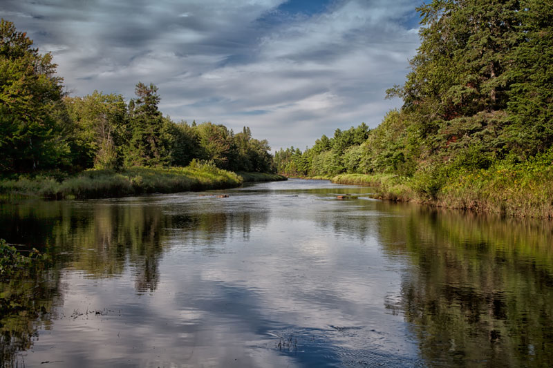
Starting in a large bog, the Canaan River was originally known by the Mi’kmaq as the Washademoak, but the Loyalist settlers of New Canaan, Connecticut, renamed it for the home they had left behind. Similar to the Salmon River and others in the region, the waters of the Canaan and its seventeen tributaries ran dark brown from the tannic acid in the bogs and barrens at its source. One of the principal tributaries of the lower Saint John River, its headwater meadows extended south to the hills of the southern highlands and north beyond the Salmon River. It was an area that had long intrigued Ganong.
Ganong made several side excursions into the meadows to verify points of interest and take elevation measurements and temperature readings. Then, he and Walter slipped their canoe into the Canaan River to paddle west through the low, undulating country. Moving away from the barren, the river became more clearly defined and its bed changed to gravel and sandstone as they went westward toward Washademoak Lake. As they descended the river, Ganong noted the banks gradually rose further above the water, while small boulders and ledges formed a series of rips. When they reached the train bridge spanning the river, just above the Lower North Branch Canaan, Ganong noted that: “The great height of this bridge, (eighty feet above the stream, which is here about 150 feet above the sea), shows that the general elevation of the country is higher above the river than one would suspect.”3
The water level was low, forcing the brothers to haul their canoe and equipment over the shoals for several miles. Just below the Petitcodiac Road bridge, Ganong noted an unusual granite outcrop standing out from the sandstone that dominated the region’s geology. Continuing downriver, they entered the broad, open countryside and gently rolling hills of New Canaan. Ganong was particularly impressed by the uniform contours of the landscape “and especially by the regularity of the convex up-roll of the grassy and bushy banks to the terrace of equal uniformity of height, some fifteen feet above the river.”4
Ganong was excited to find the portage between the Washademoak (Canaan) and the Petitcodiac located just above the bridge spanning the river at New Canaan. He believed this was “one of the most important of all the early portage paths in New Brunswick, for it lay on the route of the old French and Indian line of travel between the Chignecto region and Quebec.”5
True to form, Ganong inspected every tributary of the river, following along the banks and recording noteworthy features. He noted that the landscape changed just beyond the North Fork tributary, becoming similar to the undulating country along the Cains and Salmon Rivers. The tributary started almost ninety-two metres above sea level at Snowshoe Lake then dropped quickly, knifing through an unusual ledge in the sandstone before joining the Canaan. This feature intrigued Ganong, and he would later determine its importance while interviewing Chief James Paul of the St. Mary’s First Nation about geographical names.
He told me, however, that a curious ledge near the mouth of the North Fork Stream gave origin to the Indian name of that stream, Sagunik, which word, he said, means a gill of a fish, the rock having that appearance. He refers here of course, to one of the exposures of these laminated argillites.6
The only rapids on the entire river were below Riders Brook. This was the only section difficult to navigate by canoe. After that, the Canaan flowed slowly and smoothly to Washademoak Lake through channels formed by small sandstone islands.
In his report to the Natural History Society, Ganong explained the placid character of the Canaan River:

Washademoak Lake, August 2011
A striking feature of the Washademoak River is the smallness of its drop from the great basin at Nevers Brook and especially from the head of the “canal” near Alward Brook down to tidewater at Coles Island, the drop, indeed being smaller than that of any equal length of river known to me in New Brunswick outside of the estuarine lower Saint John.7
The brothers canoed from the Washademoak into the Saint John River just below the Cambridge Narrows and paddled upriver to Fredericton, ending the 1912 summer field trip.