Introduction
Photographing Ganong’s New Brunswick
My interest in William Francis Ganong began while conducting research for my books on the waterfalls of New Brunswick. A 1908 paper on the morphology of New Brunswick waterfalls, one of Ganong’s many reports to the Natural History Society of New Brunswick, caught my interest. It was my introduction to one of the province’s most fascinating characters and began a personal quest to understand the gripping force that compelled him to explore New Brunswick.
As my research expanded from the Fredericton Public Library to the Legislative Library to the New Brunswick Museum in Saint John, I uncovered other fascinating Ganong monographs. I discovered that the importance of his work on the province’s natural history was well understood by academics, and he was even named a Person of National Historic Significance in 1945. Yet the general public seemed to know little about the man, his writings, and the extraordinary scope of his field trips throughout the province. I decided that the best way for me and others to truly appreciate Ganong’s comprehensive body of work was to follow him into the wilderness. I wanted to find the places he had mapped, sketched, and described in his field notes, and I needed to photograph them.

An excerpt from the notes written by William F. Ganong of his 1902 field trip (NBM, William Francis Ganong Collection, F455-Adder Lakes)
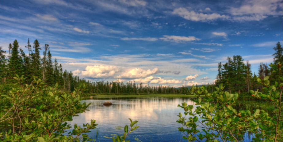
North Branch Renous River, Northumberland County, August 2011
Ganong’s field trips, research, and correspondence were extensive, and it was no small task to settle on which of these to document and include in this book. I decided to travel to the locations that I found in his reports, in his friends’ field notes, and in the photographs they took. His original pocket-sized notebooks are in the New Brunswick Museum, but age and difficult penmanship made them not very useful for my purpose. Instead, I relied on Natural History Society bulletins from 1882 to 1912 for his notes and maps, as well as field notes written by his companions Mauran Furbish and Arthur Pierce. By combining material from these sources, I was able to determine the intended routes of Ganong’s field trips and their time sequence.
With the aid of current topographical maps and Google Earth, I pored over his hand-sketched maps and detailed reports to identify coordinates and potential routes to the sites. I attempted to find the exact locations where Ganong had stood when he conducted barometric readings to measure the height of a mountain or took a series of compass bearings to triangulate a location to a known reference point. As I read and researched, my resolve hardened. Every time I hiked through the forest to photograph a landscape or waterfall, I thought about this book. On several occasions, I questioned my motive in starting such an ambitious project, always coming back to the same conclusion: I had to satisfy my curiosity about William F. Ganong and see for myself the natural places that had so impressed and intrigued him.

Dr. William Francis Ganong surveying from summit of Chief’s Mountain, Northumberland County, 1905 (NBM, William Francis Ganong Collection, Image 1987-17-1219-66)
I wanted to illustrate the breadth and reach of his trips, so I decided to include the field trips that I thought readers would find most interesting. As well, I have included some of the fascinating, and sometimes eccentric, vignettes that Ganong published as Sundry Items. His opinions on natural phenomena in articles such as “The Fact Basis of the Fire (or Phantom) Ship of Bay Chaleur” illustrate the diversity of his interests and provide further insight into his personality. Photographing notable landscapes and features that he had described was key to my project. As it turned out, some of the most pleasurable places to photograph were the various canoe trips, in particular the Restigouche River and upper section of the Nepisiguit River. In many instances, I found that the appearance of the location had altered since Ganong’s time, either through natural changes or human intervention.
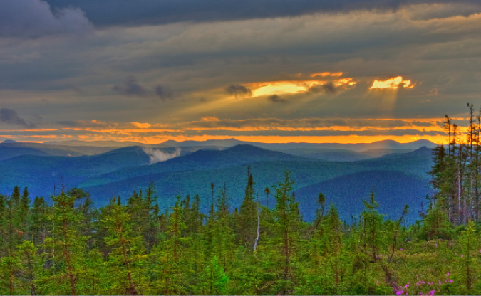
Looking west from Mount Ganong towards Mount Carleton Provincial Park, Restigouche County, June 2011

Looking up Patchell Brook Gorge, Northumberland County, May 2012
Unlike Ganong, I had to limit the time I took for research and travel, fully understanding that there would always be the siren call of another place to visit. I excluded Ganong’s 1907 field trip in the Tobique River valley since details of that watershed are included in Field Trip 6 in this book. As well, I did not include excursions to the Dungarvan and Bartholomew Rivers or the excursions that followed his 1912 canoe trip down the Canaan River. A complete list of Ganong’s field trips and the titles of his 138 monographs in the Natural History Society of New Brunswick bulletins are, however, in the appendices at the end of this book.
Like Ganong, I usually travelled with a friend or two for safety and companionship. With field notes, maps, GPS, compass, and, most importantly, my camera equipment, we tramped through dense forests, waded across brooks and streams, slogged through wet meadows, and scrambled down steep mountainsides to find the landscapes and features that Ganong documented. There were many memorable moments, such as when I stood with friends Rod O’Connell and Karl Branch on the crest of the mountain named for Ganong and gazed westward toward the encircling mountains that embraced the setting sun.
Heat and the inevitable black flies and mosquitoes made some memories less pleasant. An exhausting field trip to photograph the boulder scree that forms the south face of the ravine above Patchell Brook taught me about the grit and determination I would need to follow Ganong — and the need to choose the right season.
Timing was only one of many lessons that I learned as I worked to find and photograph the terrain and rivers Ganong explored and mapped. On occasion, I ventured out alone in search of several locations to photograph. My respect for the dogged determination he brought to his explorations increased, as did my appreciation for his love of the New Brunswick landscape. Ganong must have felt it was his responsibility to create a body of scientific work for future generations before the pristine wilderness was lost to the development he already saw encroaching. I believe he saw his maps and articles as an investment on behalf of the province of his birth. This book is my opportunity to tell others about William Francis Ganong, his amazing explorations, his contributions to the study of natural history, and his continuing importance to the province of New Brunswick.