1 Myrtle Edwards Park to Elliott Bay Park
This urban bayside hike near Seattle’s busy waterfront follows a flat, paved path past landscaped gardens and world-class sculptures. The trail traverses two adjoining shoreline parks, the entire length showcasing spectacular city, bay, mountain, and island views, with plenty of opportunities to spot marine wildlife.
Distance: 3.4 miles out and back
Approximate hiking time: 1.5 hours
Difficulty: Easy, flat trail
Trail surface: Paved
Best season: Year-round
Other trail users: Foot traffic only; runs parallel to a designated bike path
Canine compatibility: Leashed dogs permitted
Fees and permits: No fees or permits required
Schedule: Open daily. Myrtle Edwards Park is open twenty-four hours a day; Elliott Bay Park is open 6:00 a.m. to 11:00 p.m.
Maps: USGS Seattle South R and Seattle North R; Seattle street map
Trail contacts: Myrtle Edwards Park, Seattle Parks and Recreation, (206) 684-4075; www.seattle.gov/parks
Elliott Bay Park, Port of Seattle, (206) 728-3000; www.portseattle.org/community/resources/parks/index.shtml
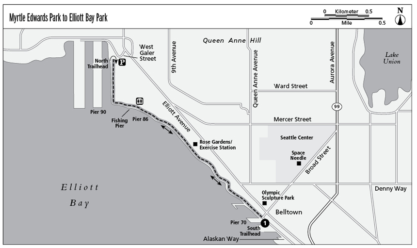
Finding the trailhead: The trail is accessible from the north or south end. The south trailhead is located on the waterfront at the foot of Broad Street and is the best access point for those who are downtown on foot. Hikers wanting free parking should begin the hike at the north trailhead at the opposite end of the park. To access the north trailhead from downtown, drive north on Elliott Avenue. Turn left onto West Galer Street, and turn left after 1 short block. The street ends at the park’s parking lot. GPS: N47 36.91' / W122 21.31' (south trailhead); N47 37.95' / W122 22.70' (north trailhead)
The Hike
The Myrtle Edwards Park to Elliott Bay Park Trail was designed to showcase the best of Seattle’s scenery—downtown skyscrapers, the iconic Space Needle, Puget Sound, Seattle’s busy port, Bainbridge Island, the Olympic Mountains, and Mt. Rainier—and it does not disappoint.
The south trailhead begins at the fountain between Pier 70 and Seattle Art Museum’s Olympic Sculpture Park. If you have an extra half hour to spare, touring this free-admission outdoor sculpture park is a great way to either begin or end your hike.
The shoreline trail through these narrow parks is paved and flat and parallels a bicycle path among acres of grassy hillocks, landscaped gardens, picnic tables, benches, and sculptures.
Approximately midpoint up the trail, you pass a sign that welcomes you to Elliott Bay Park, but not to worry—you’re not lost. Elliott Bay Park, managed by the Port of Seattle, is a seamless extension of Myrtle Edwards Park, which is managed by Seattle Parks and Recreation and named in honor of Myrtle Edwards, a former member of the Seattle City Council who championed the conservation of much of the city’s land as public space.
Continuing north, you come to a formal rose garden surrounded by a boxwood hedge. Beside the garden, an outdoor exercise station is waiting for those compelled to add some push-ups, pull-ups, or crunches to their hike. Beyond the rose garden, you pass the Port of Seattle’s Pier 86 Grain Terminal and then the Elliott Bay Fishing Pier, where you can watch people pull in the catch of the day. You’ll find restrooms, a water fountain, and vending machines here.
The trail continues north along Pier 90’s waterway to a parking lot and the alternative (north) trailhead for this hike. Turn around and retrace your steps back to the starting point.
Miles and Directions
0.0Start at the south trailhead, which begins at Pier 70.
1.0Come to a sign for Elliott Bay Park.
1.2Pass the Elliott Bay Fishing Pier.
1.7Reach the parking lot and Pier 90 trailhead. Retrace your steps.
3.4Arrive back at Pier 70.