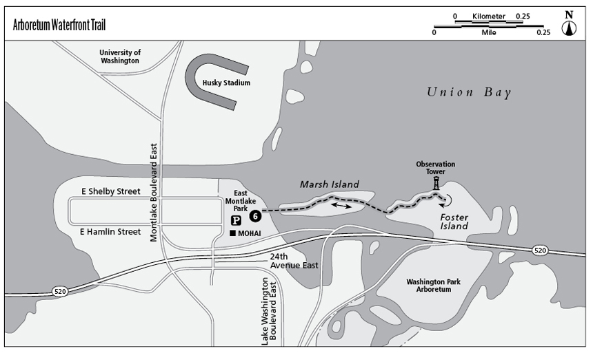
6 Arboretum Waterfront Trail
A ship canal slices Seattle in half, connecting Puget Sound to Lake Washington. At the lake end of the canal, the Arboretum Waterfront Trail follows the marshy shoreline across two islands with views across Union Bay to the University of Washington and Husky Stadium. It is part of a larger network of trails through the 230-acre Washington Park Arboretum and offers an up-close glimpse of marshland flora and fauna, making this easy trail a hit with wildlife photographers.
Distance: 0.9 mile out and back
Approximate hiking time: 30 minutes
Difficulty: Easy, flat trail
Trail surface: Soil, bark, concrete and metal grate footbridges
Best season: Year round
Other trail users: None
Canine compatibility: Leashed dogs permitted
Fees and permits: No fees or permits required
Schedule: Open daily from dawn to dusk
Maps: USGS Seattle North E; Seattle street map
Trail contacts: Washington Park Arboretum, University of Washington, (206) 543-8800; www.depts.washington.edu/wpa
Finding the trailhead: From Interstate 5 take exit 168 and merge onto Highway 520 East. Take the first exit (Montlake Boulevard). Immediately across Montlake Boulevard, make a slight right at Lake Washington Boulevard East and turn left at 24th Avenue East. Follow the signs to McCurdy Park and the Museum of History and Industry (MOHAI). Park in the lower lot behind the museum and look for a trailhead kiosk near the lakeshore. GPS: N47 38.75' / W122 17.98'
The Hike
For many Seattleites, the Arboretum Waterfront Trail is a favorite. Its short length offers a quick, accessible break from city life. Footbridges carry a sizable length of the route over the water, giving the trail a unique character. Views of the university, passing boat traffic, and the abundant waterfowl that make the marshes their home give hikers plenty to look at; binoculars or a camera come in handy on this hike.
Begin the trail at the kiosk at the water’s edge behind the Museum of History and Industry. The kiosk displays an excellent map of the trail. Follow the trail to the right. Almost immediately, the trail crosses a footbridge to Marsh Island, where the raised bark-covered trail keeps your boots dry as it cuts through low, marshland woods and along the lakeshore. A few short spur trails lead to tucked-away concrete floats that are great spots for hikers to stop and view the lake activity as well as docking spots for kayakers and canoers.
As you hike this trail, you may be aware of the rush of traffic on nearby Route 520 as it flows onto the Evergreen Point Floating Bridge. The traffic doesn’t seem to deter hikers, as evidenced by the trail’s heavy use.
The trail leads across a bridge from Marsh Island to Foster Island. On Foster much of the trail is built on a network of bridges that lead you away from shore for a duck’s-eye view of the marshy shoreline. This is one of the most interesting features of the trail and is a great place to spot a variety of waterfowl. After the bridge, a short spur trail leads to a raised viewing platform that offers superb views of the ship canal, Lake Washington, the University of Washington, and the waterfront homes of the Laurelhurst district across Union Bay.
Continuing on the main trail for a short distance brings you to the end of the Arboretum Waterfront Trail and the beginning of the trail that leads farther into the arboretum. Turn around at this point and retrace your steps back to the trailhead, or continue on for a further exploration of the 230-acre park.

Miles and Directions
0.0Start at the kiosk near the lakeshore. Facing the kiosk, the trail leads to the left or the right. Follow the trail to the right.
0.5Reach a kiosk where the trail leaves the marsh and enters an open grassy area. Turn around here and retrace your steps. Option: For an extended hike, continue following this trail to the right to reach a larger network of Washington Park Arboretum trails.
0.9Arrive back at the starting point kiosk.