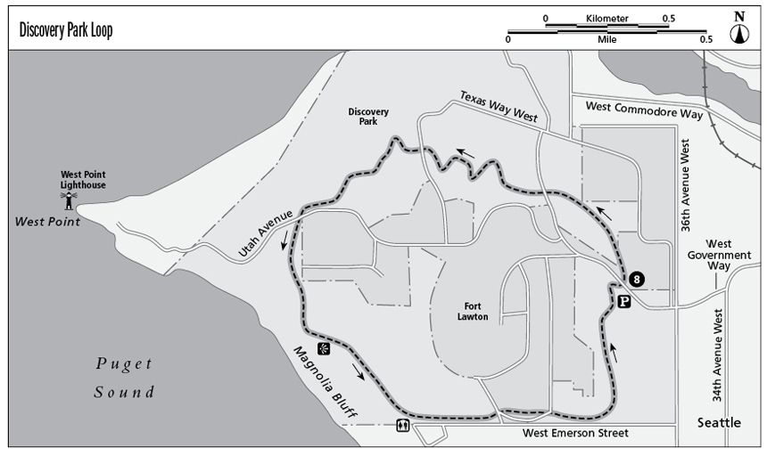
8 Discovery Park Loop
Occupying 534 acres atop Seattle’s Magnolia Bluff, Discovery Park is Seattle’s largest. The first European ship to explore Puget Sound, Capt. George Vancouver’s sloop Discovery, was the park’s namesake. Hikers will discover nearly 12 miles of trails meandering through forests, open meadows, sand dunes, and sea cliffs. The longest, at 2.8 miles, is the Loop Trail, offering sweeping views of Puget Sound, Alki Point, Vashon, Blakely, and Bainbridge Islands, and the Olympic Mountains.
Distance: 2.8-mile loop
Approximate hiking time: 1.5 to 2 hours
Difficulty: Moderate due to a series of short hills
Trail surface: Packed dirt; paved in a few short stretches
Best season: Year-round
Other trail users: Bicycles and skaters permitted on paved sections only
Canine compatibility: Leashed dogs permitted
Fees and permits: No fees or permits required
Schedule: Open daily, 6:00 a.m. to 11:00 p.m.
Maps: USGS Seattle North W; Seattle street map
Trail contacts: Seattle Parks and Recreation, (206) 684-4075; www.seattle.gov/parks
Finding the trailhead: From downtown Seattle drive west on Denny Way, which becomes Elliott Avenue and eventually 15th Avenue West. Take the Dravus Street exit and turn left at the light onto Dravus Street. Turn right at 20th Avenue West, which becomes Gilman Avenue West and eventually West Government Way. The street ends at the entrance to the park. For easy access to the trail, in the first lot on the left (east parking lot) park inside the park. The trail begins at the information kiosk. GPS: N47 39.50' / W122 24.35'
The Hike
Discovery Park occupies the grounds of Fort Lawton, a former U.S. military base, most of which has been acquired by the city of Seattle for public use. This large park encompasses a variety of terrain, and the well-maintained and heavily traveled Loop Trail passes through them all. This trail is clearly marked at intersections with minor trails and service roads, so if you follow the signs you can’t go wrong.
Beginning from the kiosk beside the east parking lot, start walking in a counterclockwise (north) direction. Immediately enter the forest and head up a gentle incline. For much of its length, the trail roller-coasters through a series of easy grades, but the trail is moderately steep (roughly a 10 to 15 percent grade) in a few short spots, so trekking poles can be helpful.
Views throughout most of the hike are limited to the woods, hillsides, ravines, and the creatures that live there, so be on the lookout for bald eagles, great blue herons, woodpeckers, and many other species of birds.
About halfway through the hike, the trail approaches the edge of Magnolia Bluff, a 200-foot sea cliff. Here the expansive eagle’s-nest view is breathtaking, and the open terrain of meadow and sand dunes ensures an unobstructed panorama. This is a great spot to linger and take in the ship and ferry traffic below, or simply contemplate the natural beauty of the Puget Sound region. It’s tempting to step up to the edge of the bluff, but be sure to observe the warning signs and stay behind the designated area. The bluff is unstable and prone to collapse.
When you’re ready to tear yourself away from the view, the trail leads you away from the bluff. The buildings on the hill ahead of you are remnants of the old military base, Fort Lawton Military Reservation, which was instrumental in housing troops in transit during World War II and also served as a POW camp during the war.
The trail heads into the forest again along the south end of the park and soon skirts the right edge of a parking lot (the south lot). Watch for trail markers indicating the Loop Trail and/or the visitor center. They are the same trail and will lead you back to your starting point at the east parking lot trailhead.
Miles and Directions
0.0Start at the information kiosk near the entrance to the east parking lot and head counterclockwise (north) on the well-marked trail.
1.7The trail skirts Magnolia Bluff. Be careful to stay away from the edge as you enjoy the views.
2.0Pass Fort Lawton Military Reservation.
2.3Skirt the right edge of the south parking lot and look for the Loop Trail/visitor center signs.
2.8Arrive back at the east parking lot trailhead.