10 Magnuson Park
Warren G. Magnuson Park occupies the site of the former Sand Point Naval Air Station on Lake Washington. When the base was closed, the city of Seattle acquired the land and buildings for public use, making good use of the waterfront and wide-open spaces for recreational and athletic facilities, including miles of trails. (NOTE: As of this writing, large sections of the park were under renovation to restore wetlands and natural habitats as well as improve the athletic fields. Additional hiking trails will be available when the project is completed.)
Distance: 2.6-mile lollipop
Approximate hiking time: 1.5 hours
Difficulty: Easy, with one hill
Trail surface: Paved, gravel
Best season: Year-round
Other trail users: Bicyclists, skaters
Canine compatibility: Leashed dogs permitted; large off-leash area nearby
Fees and permits: No fees or permits required
Schedule: Open year-round; May 1 through Labor Day, 4:00 a.m. to 11:30 p.m.; Labor Day through April 30, 4:00 a.m. to 10:00 p.m.
Maps: USGS Seattle North E and Bellevue North W; Seattle street map
Trail contacts: Seattle Parks and Recreation, (206) 684-4075; www.seattle.gov/parks
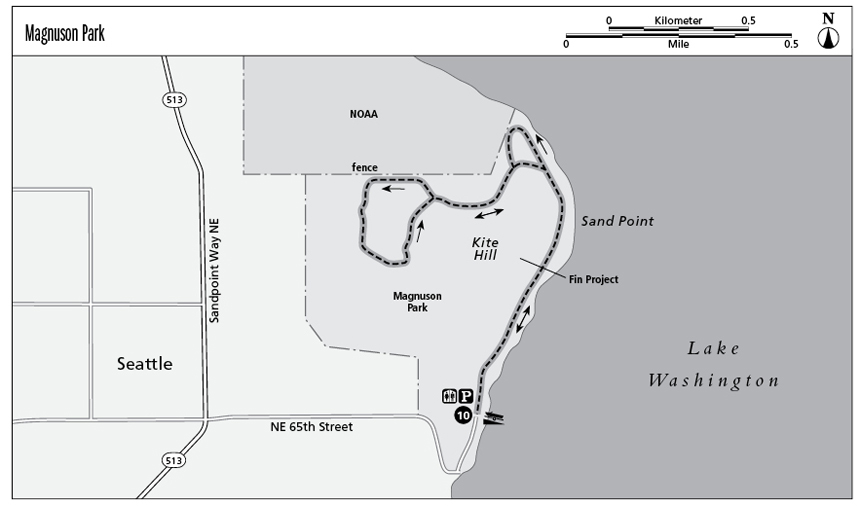
Finding the trailhead: From downtown Seattle drive north on Interstate 5 and take exit 169 (Northeast 45th Street). Turn right onto Northeast 45th Street and follow it past the University of Washington and down the hill. The street becomes Sandpoint Way NE and curves to the left. Turn right at Northeast 65th Street, which ends at the Magnuson Park parking lot. The trailhead is to the left of the boat ramp as you face the lake. GPS: N47 40.55' / W122 15.04'
The Hike
Lake Washington stretches 20 miles along Seattle’s entire eastern border and beyond, its shoreline home to miles of promenades, parks, bicycle trails, waterfront homes, neighborhood commercial districts, a hydroplane racing pit, the on-ramps of two floating bridges, and even the site of a former naval air station. When the Sand Point Naval Air Station closed, the city of Seattle seized the opportunity to acquire the lakefront property to create Magnuson Park, which now shares Sand Point with the National Oceanographic and Atmospheric Administration (NOAA).
Magnuson Park contains miles of trails. This hike follows the lakefront promenade, ascends Sand Point Head (aka Kite Hill), and circles a hilltop field with excellent views up and down the lake, east to the city of Kirkland, and beyond to the Cascade Mountains.
About midway along the promenade, you will notice something resembling killer whale dorsal fins—twenty-two of them in all—breaching the lawn as it gently rolls like waves. These are actually black diving fins from decommissioned Navy attack submarines buried in the hillside, creating a provocative art installation titled The Fin Project.
The promenade ends at a gate leading to a high point of the hike for your canine companion, if you brought one: an enormous fenced off-leash area that meanders through the park. This optional delight for your dog will temporarily take you off the trail, but you can backtrack and easily find the gate again and continue up Kite Hill to resume the hike.
A nearby attraction resides on the secured grounds of NOAA: the lakefront Art Walk. One of the highlights of the collection is Sound Garden, a collection of pipes that play eerie sounds in the wind, the tone and pitch determined by the wind’s direction and velocity. To access Art Walk, go to the NOAA security gate on Northeast 63rd Avenue, immediately to the north of the park, and request access to the Art Walk. If the current security level permits, you will go through a routine security screening, be issued a visitor’s pass and permitted to enter.
Miles and Directions
0.0Start at the lakeside promenade next to the boat launch at the park’s south parking lot. Cross the footbridge and follow the promenade north.
0.4The trail passes The Fin Project, an art installation.
0.7The trail reaches the off-leash area for dogs and turns to the left along the fence.
0.8At the trail intersection, turn right and follow the trail up Kite Hill and beyond to the athletic fields. Circle the field for great views of the park, and then take the same trail back down the hill.
1.9Walk straight through the trail intersection toward the lake.
2.0Turn right at the lakeside promenade and walk south toward the trailhead.
2.6Arrive back at the trailhead.