12 Soos Creek Trail
The Puget Sound Basin is laced with wetlands, many accessible by excellent, well-maintained trails. Soos Creek is a prime example of a wetland ecosystem in which the creek feeds ponds and swamps and supports a rich diversity of plant and animal life. A multiuse trail extends more than 7 miles one-way beside the creek; this hike explores the northern segment of that trail.
Distance: 5.0 miles out and back
Approximate hiking time: 2 to 2.5 hours
Difficulty: Moderate due to distance and a few gradual inclines
Trail surface: Paved
Best season: Year-round
Other trail users: Bicyclists, skaters, equestrians (on the soft surface shoulder and parallel horse trail)
Canine compatibility: Leashed dogs permitted
Fees and permits: No fees or permits required
Schedule: Open-year round, dawn to dusk
Maps: USGS Renton, WA; South King County street map
Trail contacts: King County Parks and Recreation, (206) 296-8687; www.kingcounty.gov/recreation/parks.aspx
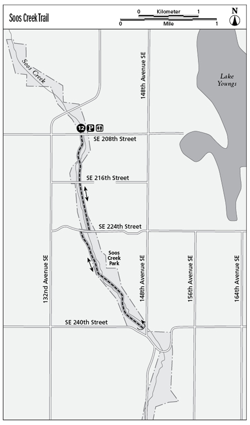
Finding the trailhead: From Seattle drive south on Interstate 5. Take exit 152 (South 188th Street/Orillia Road South) and turn left onto South 188th Street, which immediately curves right onto Orillia Road South. Follow Orillia Road South down the hill; the road curves left and become South 212th Street. Follow this street through the valley, under the Highway 167 overpass, and up the hill where it becomes Southeast 208th Street. Turn left into the signed parking lot at Soos Creek Park. GPS (north trailhead): N47 24.97' / W122 9.56'
The Hike
A long stretch of Soos Creek—an important tributary of the Duwamish and Green River Watershed—is bordered by a wide greenbelt of wetlands that has been set aside as a county park with a paved multiuse trail. This trail offers an excellent opportunity to explore a natural wetland environment without traveling far from the city.
The trail begins at Soos Creek Park, which has parking, restrooms, a picnic shelter, and a children’s play area. A short spur of the Soos Creek Trail heads north through the park and dead-ends in 0.5 mile. Instead, for a longer hike through the wetlands, cross the street and the footbridge and head south on the paved trail.
At first the trail cuts a path close to pastures and stables, but soon the wetlands expand and the landscape is rich with cattails, alders, and other wetland vegetation above the surface of the water and plants such as water parsley below. The branches here are heavy with moss, and opportunistic ferns set down roots wherever they can. This trail is popular with birders for a reason; watch for waterfowl, hawks, and other birds that make the wetlands their home.
At the 0.5-mile point, the trail crosses a street. At 1.0 mile a country road interrupts the trail, but the trail resumes across the road about 450 feet to the right. Here the trail follows some power lines for about 0.25 mile but never leaves the wetlands. The trail then heads up and down a few gentle slopes as it enters a riparian forest that overlooks the creek below.
You eventually hear but not see evidence of civilization again, with the roar of a highway just up the ridge. When you come to the next road, you can turn around and retrace your steps back to the trailhead to complete the 5.0-mile round-trip hike or cross the road and continue on to add more mileage.
Miles and Directions
0.0Start at the north trailhead, across the street from the park. Cross the street and continue south across the footbridge.
0.5The trail crosses another street.
1.0Come to a rural road. Turn right onto the road, walk 450 feet, and turn left onto the trail, which is well marked.
2.5Turnaround and retrace your steps back to the trailhead. Option: For a longer hike—more than twice the length, round trip—continue on to the south end of the trail, where you will turn around and return to the north trailhead.
5.0Arrive back at the north trailhead.