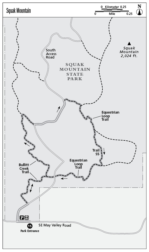
15 Squak Mountain
Squak Mountain has been preserved as a vast, wooded state park that’s just minutes from Seattle. Its trails range from easy to difficult, but all have one thing in common: They share a quintessential Pacific Northwest forest that’s closed to all activity except hiking, running, and, on designated trails, horseback riding (so watch your step).
Distance: 3.4-mile lollipop
Approximate hiking time: 2.5 hours
Difficulty: More challenging due to a 700-foot elevation gain and loss
Trail surface: Dirt and gravel
Best season: Year-round
Other trail users: Equestrians on segments of the trail
Canine compatibility: Leashed dogs permitted
Fees and permits: No fees or permits required
Schedule: Open year-round; summer hours, 6:30 a.m. to dusk; winter hours, 8:00 a.m. to dusk
Maps: USGS Maple Valley; King County street map
Trail contacts: Washington State Parks, (360) 902-8844; www.parks.wa.gov
Finding the trailhead: From Interstate 90 take exit 15 and follow Highway 900 south. Turn left onto Southeast May Valley Road and turn left into Squak Mountain State Park. The trailhead is on the left side of the parking lot. GPS: N47 28.90' / W122 3.26'
The Hike
The Issaquah Alps have many outstanding features that rank them among the best recreational assets in the Seattle area. One of those is their close proximity to the city. Squak Mountain, the “alp” between Cougar and Tiger Mountains contains a network of trails crisscrossing the heavily wooded hillsides. The trails can be muddy and some have moderately steep stretches, so trekking poles are a good idea.
Although the Squak Mountain route described here, which explores the south flank of the mountain, has an approximate 700-foot elevation gain and loss, it was selected for this guide to allow hikers to experience the park’s natural environment without excessive uphill hiking. The lasso-shaped route begins at the south trailhead at the parking lot and loops clockwise uphill on the lower portion of the Bullitt Creek Trail, up a portion of the South Access Road (closed to motorized public traffic) and down the Equestrian Loop Trail, with a few connector and shortcut trails in between.
A short distance past the trailhead, an optional, flat 0.3-mile interpretive nature trail loops through the forest. To the right of the nature trail, the Bullitt Creek Trail—the beginning of your route—begins.
Squak Mountain’s story, like so many in the Pacific Northwest, is one of stewardship and conservation. Until the mid-twentieth century, Squak Mountain was heavily logged and mined. A prominent Seattle family rescued the mountain from commercial enterprise and donated the land to the state with the proviso that it be allowed to return to its natural state. Today visitors to Squak Mountain State Park have to look hard to find any reminders of the mountain’s commercial past. Nature has reclaimed the mountain with a vengeance. The trails meander up and down through moss- and fern-laden forest, through thickly wooded ravines, and beside and over cascading creeks and waterfalls. You won’t find sweeping vistas on this route, but you will find a quiet, meditative forest.
Since some Squak Mountain trail junctions are unmarked, it’s easy to get lost or inadvertently extend your hike. An excellent supplement to the map provided with this hike is the trail map available at the trailhead kiosk. With a park map you can follow the route described here or create your own. If you create your own route, be mindful of distance and elevation gain.

Miles and Directions
0.0Start at the trailhead at the Squak Mountain State park parking lot.
0.1The trail crosses South Access Road and resumes to the right of the nature trail. On the state park trail map, this is identified as the Bullitt Creek Trail.
0.5Come to a junction and follow the left fork to remain on the Bullitt Creek Trail.
1.0At the junction, follow the right fork, leaving the Bullitt Creek Trail.
1.2The trail joins the South Access Road; turn left and follow the road up the hill.
1.5The Equestrian Loop Trail intersects the road on the right; turn right onto the trail.
1.6At the junction, turn right to remain on the Equestrian Loop Trail and follow it down the hill.
2.3At an easy-to-miss junction, marked as Trail S5, turn right onto S5, a shortcut that leaves and rejoins the main trail. If you miss the junction and remain on the Equestrian Loop Trail, you will simply extend your hike.
2.5Trail S5 ends at the Equestrian Loop Trail. Turn right and follow it down the ravine, across the footbridge, and up the hill, where it will eventually cross the South Access Road and continue on.
2.9The trail forks; follow the left fork onto the Bullitt Creek Trail.
3.4Arrive back at the trailhead and parking lot.