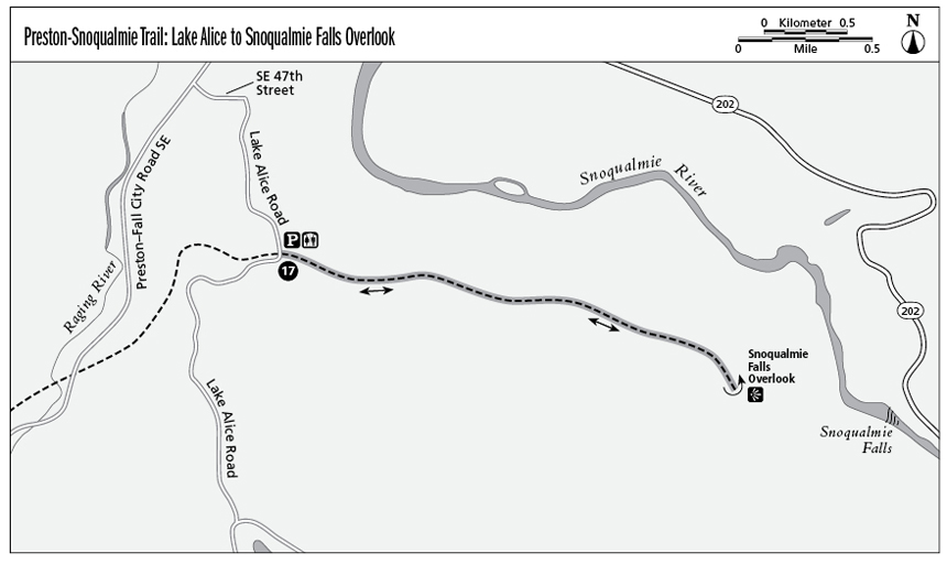
17 Preston-Snoqualmie Trail: Lake Alice to Snoqualmie Falls Overlook
The historic Preston-Snoqualmie Trail crosses the foothills above the Raging River Valley, a 6.5-mile trail that is a part of the much larger network of King County Regional Trails. This short hike takes in the most scenic portion of the trail—the last few miles at its eastern end. What’s so scenic? The trail terminates at a viewpoint that looks across the valley to 268-foot-high Snoqualmie Falls.
Distance: 3.7 miles out and back
Approximate hiking time: 1.5 to 2 hours
Difficulty: Easy, flat trail with one gentle incline
Trail surface: Paved
Best season: Year-round; the winter rainy season adds volume to the falls.
Other trail users: Bicyclists, skaters
Canine compatibility: Leashed dogs permitted
Fees and permits: No fees or permits required
Schedule: Open year-round, dawn to dusk
Maps: USGS Fall City and USGS Snoqualmie; King County street map
Trail contacts: King County Parks and Recreation, (206) 296-8687; www.kingcounty.gov/recreation/parks.aspx
Finding the trailhead: From Seattle drive east on Interstate 90 and take exit 22. Turn left and drive over the overpass. Turn right at the first intersection and drive through Preston. The road becomes Preston–Fall City Road SE. Turn right onto Southeast 47th Street and then right onto Lake Alice Road. Drive up the hill until you reach the well-signed trailhead and turn right into the parking lot. GPS: N47 33.05' / W121 53.23'
The Hike
Snoqualmie Falls is the site of the region’s first hydroelectric plant, built in 1898. Still in operation, the plant provides the Seattle metropolitan area with much of its power.
Nearly 100 feet higher than Niagara Falls, Snoqualmie Falls drop from a height of 268 feet; the width varies based on the time of year and the amount of rainfall. The site of the falls attracts 1.5 million visitors a year, but from the Preston-Snoqualmie Trail, you’re likely to have the view of the falls all to yourself.
This paved, straight, gradually graded trail begins in a residential area in rural King County, but soon the residential properties thin out and the trail follows the side of wooded Snoqualmie Ridge high above the Raging River and Snoqualmie River valleys. In spite of the trail’s proximity to civilization, a sign at the trailhead with graphics of a bear and cougar remind you that you are treading in wildlife habitat.
The trail follows a historic railroad grade (as do many of the region’s trails) that played a major role in populating the fertile valleys at the foot of the Cascades as well as transporting timber and coal. Today there’s no visible evidence of the area’s timber and railroad history along this portion of the Preston-Snoqualmie Trail.
History buffs will enjoy a separate visit to the trail’s nearby namesake towns: the historic sawmill town of Preston and the railroad town of Snoqualmie, home to the Northwest Railroad Museum, with its period depot and impressive collection of vintage railroad cars lining the main street.
If treading in a place that had a hand in shaping the region’s history doesn't entice you, the view at the end of the trail surely will: the long drop of Snoqualmie Falls, the visitor center and lodge perched at the top of the falls, and the jagged Cascade peaks rising above it all.
Miles and Directions
0.0Start at the trailhead, which is across Lake Alice Road from the parking lot.
0.5The trail gradually descends into a shallow ravine and out again.
0.7The trail passes a viewpoint with benches overlooking the Snoqualmie Valley.
1.8The trail dead-ends at the Snoqualmie Falls overlook. Retrace your steps.
3.7Arrive back at the trailhead.