18 Twin Falls Trail
Some hikes are extraordinary for the beauty of the terrain they cross and some for the reward at the end of the trail. The Twin Falls Trail is extraordinary for both. The trail follows the South Fork of the Snoqualmie, passes through old-growth forest, and reaches two breathtaking waterfalls, one above the other.
Distance: 2.5 miles out and back
Approximate hiking time: 2 hours
Difficulty: More challenging due to switchbacks and a net elevation gain and loss of approximately 500 feet
Trail surface: Dirt, wooden footbridge
Best season: Spring through fall; winter snow and ice can make the trail inaccessible or at least difficult.
Other trail users: None
Canine compatibility: Leashed dogs permitted
Fees and permits: No fees or permits required
Schedule: Open year-round; 8:00 a.m. to dusk
Maps: USGS Chester Morse Lake; King County street map
Trail contacts: Washington State Parks, (360) 902-8844; www.parks.wa.gov
Finding the trailhead: From Seattle drive east on Interstate 90 and take exit 34. Turn right onto 468th Street SE and turn left onto Southeast 159th. The road ends at the trailhead parking lot. GPS: N47 27.18' / W121 42.34'
The Hike
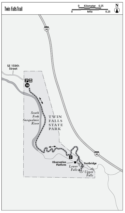
Twin Falls is accessible from two trailheads, one above the falls and one below. Both are within the boundaries of Olallie State Park, although the lower trailhead has signs indicating it is Twin Falls State Park. According to the Washington State Park map, the lower trailhead and falls are within the Twin Falls Natural Area, a portion of Olallie State Park.
The route described here starts at the lower trailhead, which begins along the bank of the rushing Snoqualmie River, its icy waters fresh from the peaks above Snoqualmie Pass. The trail winds its way through a grove of giant maples, their trunks and branches thickly coated with pads of moss and spiked with ferns, making this spot an oasis of green even in winter. The maples give way to remnants of old-growth forest, the star of which is the “Grandfather Tree,” a giant Douglas fir, 14-feet in diameter, that’s estimated to be about 700 years old.
About two-thirds of the distance to the falls, you come to benches that have been installed on a ridge, a perfect spot to catch your breath and take in the view of the falls and your ultimate destination across the canyon. Farther on, just before the falls, a stairway spurs off the main trail and leads 103 steps down to a railed wooden viewing platform perched over the edge of the gorge—directly in the face of the 135-foot lower falls. Look straight down into the jade pools, where over time the force of constantly pounding water has carved a cave into the rock. In winter the volume of water in the falls increases significantly, making the sight all the more spectacular.
When you reach the upper falls, an 80-foot-long footbridge crosses the gorge between the two waterfalls. The upper falls tumble down the rocks as though over giant stair steps; the lower falls form a straight drop-off below you. The bridge is a good turnaround point.
If you want to extend the hike, continue on past the bridge to join the Iron Horse Trail at the Upper Twin Falls trailhead.
Miles and Directions
0.0Start at the signed trailhead at the end of the parking lot.
0.7Come to a rest area with benches overlooking the waterfall.
1.1An optional spur with 103 steps leads approximately 200 feet down to a viewing platform is well worth the climb for the close-up view of the lower falls.
1.2Reach a footbridge spanning the gorge between the upper and lower falls. Turn around on the bridge and retrace your steps back to the trailhead.
2.5Arrive back at the trailhead.