20 Asahel Curtis Nature Trail
Early photographer Asahel Curtis had a passion for documenting the world around him, including the beauty of the Northwest outdoors. With logging, mining, and the influx of settlers around the turn of the twentieth century, the Northwest was about to change forever, and Curtis’s work chronicled that historic shift. It seems fitting then that a nature trail through one of the last remaining old-growth forests only an hour from Seattle should be given his name.
Distance: 1.3-mile lollipop
Approximate hiking time: 1 hour
Difficulty: Easy trail with 100-foot elevation gain and loss
Trail surface: Dirt, gravel, plank boardwalk
Best season: May through November
Other trail users: None
Canine compatibility: Leashed dogs permitted
Fees and permits: Northwest Forest Pass required; for information on purchasing a pass, see “Trail contacts” below.
Schedule: Open spring through fall, dawn to dusk; closed in winter
Maps: USGS Snoqualmie Pass; Washington state road map
Trail contacts: USDA Forest Service, Mt. Baker–Snoqualmie National Forest, (206) 470-4060 (outdoor recreation information); www.fs.fed.us/r6/mbs
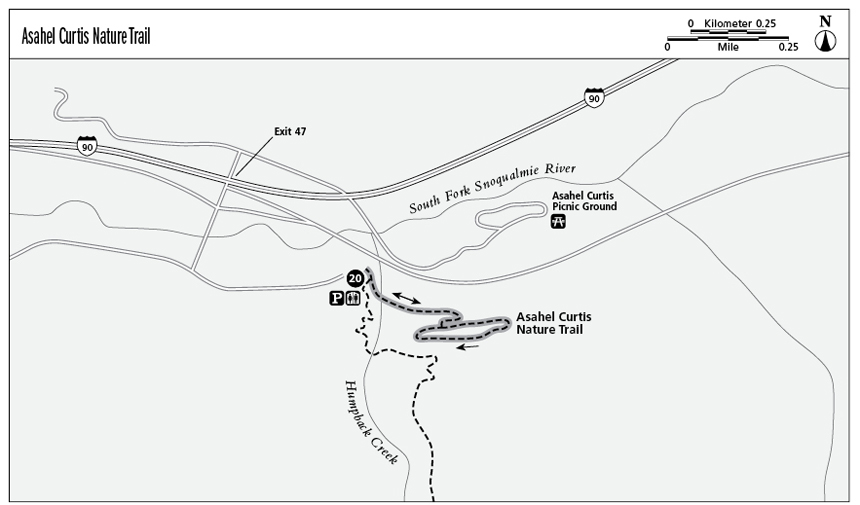
Finding the trailhead: From Seattle drive east on Interstate 90 and take exit 47. Turn right, cross the bridge, and take the first left, which leads to the parking lot. Or simply follow the signs from the freeway to the Asahel Curtis Nature Trail. GPS: N47 23.57' / W121 28.50'
The Hike
Asahel Curtis was a renowned photographer and 1906 cofounder of the Mountaineers Club. To hike the Asahel Curtis Nature Trail is literally to feel dwarfed by raw nature. Douglas fir, western hemlock, and western red cedar are among the giants still thriving there, some rising roughly 200 feet.
The trail sits just off I-90, making it very accessible and easy to find. Unfortunately, the freeway noise is a presence, but it’s one that’s easily disregarded as you begin to marvel at this ancient forest.
Pick up an interpretive brochure at the trailhead before you begin the hike. This excellent interpretive trail highlights many of the features characteristic of Pacific Northwest forests, such as nurse logs—fallen trees that become seeding ground for anything that can sprout roots or produce spores—and various native plants and trees. In spring and summer the forest floor comes alive with wildflowers—trillium, bleeding heart, wild ginger, orchids, and more.
The first part of the trail follows Humpback Creek as it tumbles and rushes through the dense forest. Sturdy log and plank bridges cross the creek several times as it hurries to become part of the Snoqualmie River. The trail gradually gains a bit of elevation as it enters the old-growth forest and eventually gives way to a marshy wetland accessible over a plank boardwalk. A word of caution: Wet planks can be extremely slippery.
Those hiking this trail in spring before maintenance crews have had a chance to do some housekeeping will probably encounter fallen trees over the trail, the casualties of fall and winter storms. Just be prepared for the fact that this may cut your hike short. It’s always a good idea to research trail conditions before you set out to avoid any disappointment, especially in spring and fall. In winter the Asahel Curtis Nature Trail is impassable due to heavy snowpack and downed trees.
In the right season, the sampling of so much natural diversity in such a short space and time makes this educational hiking experience one that’s hard to match for both children and adults.
Miles and Directions
0.0Start at the trailhead, located in the parking lot. Toilets are located at the trailhead.
0.4The loop begins here; follow the trail either to the left or the right.
0.9The loop ends; follow the signed trail back to the trailhead.
1.3Arrive back at the trailhead.