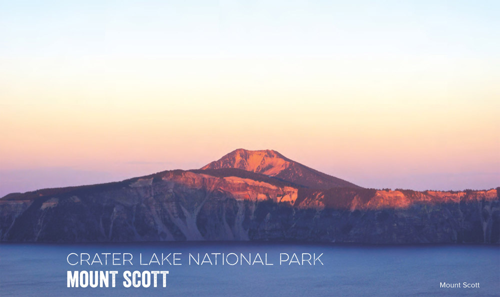
Travel into the fiery past of Mount Mazama on this 5.2-mile out-andback to the park's highest peak, where sprawling views of the deepest lake in the United States await.
At 8,929 feet, Mount Scott is Crater Lake's highest point—and perhaps the best place to see the collapsed volcano of Mount Mazama cupping one of the clearest lakes in the world like a mirror to the sky. From the trailhead parking lot, begin hiking on well-I marked trail that begins with heavy log signage. The first 0.25 mile winds up broken pumice with broad views of Mount Scott's north face. About 1 mile down the trail, breaks in the hemlocks and whitebark pines offer views of Mounts McLoughlin and (on the clearest days) Shasta, 160 miles to the south. Continue past mixed pumice and forest before beginning to switchback up the peak's north face; here, Mount Thielsen, an old volcanic neck, dominates the north horizon. You'll hit the saddle to see western vistas of Crater Lake and Wizard Island, the exposed, spiky relic of Mount Mazama's mighty lava flows.
The final summit ridge slopes upward for a gentle 0.2 mile to a fire lookout overlooking the Klamath Lake basin (Oregon's largest freshwater lake) and the surrounding high Cascade Mountains. Atop, you'll see Crater Lake, a solitary blue caldera formed 7,700 years ago by an eruption 42 times stronger than that of Mount St. Helens in 1980. Brave the wind and admire Crater Lake at a lunch spot beyond the fire lookout before turning back to retrace your steps.
DISTANCE: 5.2 miles
TIME REQUIRED: 1 day
DIFFICULTY: Intermediate
CONTACT: Crater Lake National Park, (541) 594-3000; nps.gov/crla
THE PAYOFF: Big views of Crater Lake on the park's highest peak.
TRAILHEAD GPS: 42.929440, -122.029297
FINDING THE TRAILHEAD: From Eugene, take I-5 south to Roseburg; turn east onto OR 138, and follow 165 miles to the park's north entrance. Go left at Rim Drive to head east around the lake. After 9 miles, park at the Mount Scott trailhead.
WAYPOINTS & DIRECTIONS
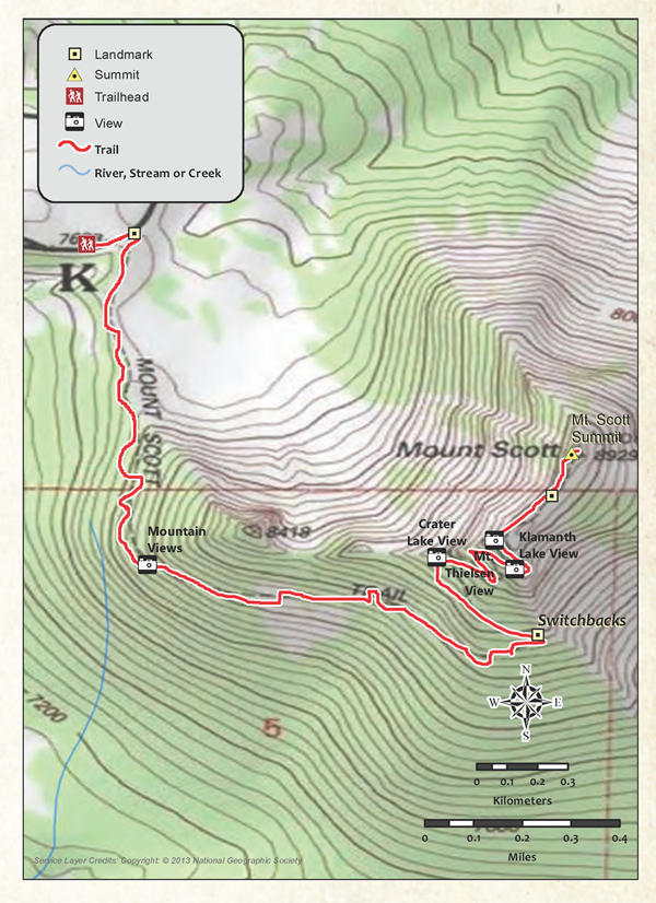
GPS: 42.929119, -122.030701 From parking lot, begin hiking on wellmarked trail.
GPS: 42.929440, -122.029297 Pass large log sign marking the trail.
GPS: 42.919609, -122.028900 Break for views of Mounts McLoughlin and Shasta to the south.
GPS: 42.917519, -122.017303 Begin substantial switchbacks as the trail climbs.
GPS: 42.919819, -122.020302 Stop here for majestic views of Crater Lake
GPS: 42.920311, -122.018600 Switchbacks continue as Mount Thielsen, an old volcanic neck, dominates the northern horizon.
GPS: 42.921650, -122.016899 Hit saddle; look to the west for vistas of Crater Lake and Wizard Island.
GPS: 42.922920, -122.016296 Arrive at craggy summit of Mount Scott (8,929 feet); continue past fire-lookout tower for lunch spots; retrace your path to the car.