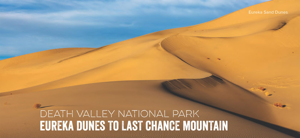
This weekend getaway travels from Eureka Dunes, the highest dunes in California, to Last Chance Mountain, an 8,500-foot peak in Death Valley.
The Last Chance Mountains stretch north to south from the Nevada border Into Death Valley National Park, bisecting Eureka Valley to the west and Death Valley to the east. The range's snowcapped, 7,000-foot mountains contrast remarkably against the sand, salt flats, and rugged canyons that surround them.
Get to this secluded range on a challenging weekend backpacking trip through one of California's emptiest quadrants. Hike north from S. Eureka Road for a moderate climb into the Last Chance Range. Make sure to turn around for views of the 700-foot Eureka Dunes, the highest dunes in California and some of the tallest in the United States. At mile 1.7, the route passes another viewpoint that showcases the dunes and the snowy Inyo Range. One mile later, the terrain flattens briefly between two 4,000-foot foothills, then continues north, following the canyon's wash. Keep left at the two forks in the canyon. After 6 miles, turn left onto Big Pine Road and follow it to Crater Mine. Just past the mine, hikers can set up camp off the dirt road on a flat area near the pass. Pick a spot with protection—this area can get very cold and windy.
The next day, follow the dirt road until it dead ends into the mountains. From here, you'll scramble up a steep, dirt slope to the first saddle in Last Chance Range. From the saddle, follow the ridgeline over 4 unnamed peaks to Last Chance Mountain. Route-finding will be necessary for this stretch to Last Chance Mountain—there is no trail and the terrain is extremely rugged. From the top of 8,456-foot Last Chance Mountain, savor views into the Last Chance Range, then turn around and follow the same route back to Eureka Dunes.
Maps and compass skills—in addition to a high level of fitness—are required for this route. You'll also want route-finding skills and the ability to haul in all your water. They don't call it Death Valley for nothing.
DISTANCE: 28.7 miles
TIME REQUIRED: 3 days
DIFFICULTY: Expert
CONTACT: Death Valley National Park, (760) 786-3200; nps.gov/deva
THE PAYOFF: California's highest dunes, extreme desert terrain.
TRAILHEAD GPS: 37.114918, -117.664433
FINDING THE TRAILHEAD: From Main Street and Line Street In Bishop, head south on N. Main Street/ US 395/US 6. In 14.6 miles, turn left at CA168. In 2.3 miles, bear right onto Death Valley Road/Waucoba Road. In 36.4 miles, turn right onto S. Eureka Road. Go 10.7 miles to the start of this hike.
WAYPOINTS & DIRECTIONS

GPS: 37.114918, -117.664432 Hike north from S. Eureka Road. Make sure to turn around for views of the 700-foot Eureka Dunes
GPS: 37.139167, -117.671676 Take a moment to stop and look around at this overlook, which showcases the dunes be low and the snowy Inyo Range. Continue north-northwest through the narrow valley between the foothills.
GPS: 37.151463, -117.678254 After climbing another 400 feet, rest at this flat, open area between two 4,000-foot foothills. Continue north through the canyon, following the wash. The canyon walls are a few hundred feet higher than the wash.
GPS: 37.172103, -117.671943 Bear left at an intersection between two canyon washes. Continue 0.75 mile over gravel, passing beautifully colored canyon walls before reaching another fork in the canyon.
GPS: 37.185765, -117.674844 Bear left at the second fork in the canyon. Once the canyon opens, continue northwest to Big Pine Road.
GPS: 37.192522, -117.680448 Follow Big Pine Road to the left and continue west-ward to Crater Mine.
GPS: 37.211720, -117.690921 After bearing left onto Big Pine Road, turn right and continue north past the mining area.
GPS: 37.220213, -117.684174 Camp off the dirt road on a flat area near the pass. Pick a spot with protection, because this area can get very cold and windy. From camp, follow the dirt road until it dead ends into the mountains. A mine shaft is at the end of the road. Route-finding will be necessary for the remaining stretch to Last Chance Mountain, there is no trail and the terrain is extremely rugged.
GPS: 37.258959, -117.681407 Scramble up a steep dirt slope to the first saddle In Last Chance Range. From the saddle, hike the ridgeline over four unnamed peaks to Last Chance Mountain. Head northwest to the first peak (7,853 feet). Go north-northwest to the second peak (7,978 feet). Continue northwest to the third peak (8,250 feet). Then head due north and turn east, skirting the ridgeline around the fourth peak (8,211 feet). Hike north then northwest along the ridge to the summit of Last Chance Mountain (8,456 feet).
GPS: 37.280141, -117.699808 Summit of Last Chance Mountain (8,456 feet). Savor views from the trip's high point, then turn around and follow the same route back to Eureka Dunes.
RANGER PROFILE
The Eye Opener
Death Valley National Park, California and Nevada
“Laura taught me that if you truly want to do something, just do it and don't look back.”
—Bobby Kerr, Backpacker reader
Death Valley has beauty In all directions, but Laura Lynn DelRoss's favorite place to look Is up. When visitors stargaze In Death Valley, she says, they always have the same reaction: “Oh no, there's a big cloud In the sky. We can't see the stars.™ When DelRoss, an Interpretive ranger, tells them that the “cloud™ Is the Milky Way, the ensuing silence Is her favorite sound In the park. “I've fallen In love with the ability to Inspire people with their natural surroundings,” she says.
FAVORITE SPOT: Mosaic Canyon
Look closely at the polished, serpentine stone curves near the entrance of this desert slot canyon. The rock contains Intricate patterns of multicolored mineral fragments that juxtapose 450-mllllon-year-old and 50-mllllon-year-old rock. DelRoss calls the resulting Mosaic Breccia “lovely chaos.” The 4-mile (round-trip) hike to a dry waterfall and back also serves up rosy-brown stone walls, winding narrows, and fun, easy canyoneering moves.
TRAILHEAD: Mosaic Canyon
INFO: nps.gov/deva
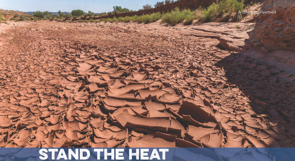
Go ahead and brave sizzling temperatures, but be respectful of the dangers. Expedition-veteran Mark Jenkins shares his hard-won lessons.
1. Have a backup plan for when the waterhole you are absolutely sure has water Is actually dry.
2. Bring hard candy to suck on while hiking.
3. Cotton retains moisture better than synthetics, and thus keeps you cooler (though It can limit range of motion).
4. Wear a full-brimmed hat and extra-dark sunglasses at all times. Even with the hat, you can get burned by light reflected off the ground. Use sunscreen on any exposed flesh, like your face and the backs of your hands, and reapply frequently.
5. Don't hike during the middle of the day, when temperatures reach their peak. Crawl as far back beneath a boulder or Inside a cave as you can. Read a book, take a nap. Bring dark sunglasses.
6. Rely on yourself, not your guides or companions, to ensure you will have water.
7. Don't wear shorts or short sleeves. When the ambient temperature Is above your body temp, more layers actually keep your body cooler. That's why you see Bedouins and other desert dwellers wrapped up.
8. Take off your boots and socks at every stop. This will keep your feet from baking and blistering. Change salty, sweaty socks frequently.
9. Know with certainty—absolute certainty—where your next source of water is and how long it will take to get there In severe conditions.
10. In desperation, peeing your pants Is an effective method for cooling off.
11. Use a bladder with a mouthpiece rather than a bottle. You'll always drink more. Always bring a backup water bag.
12. If you're working hard in extreme heat, drink 5 quarts of water a day. Add a pinch of electrolyte mix to each quart (go easy on sweeteners; too much sugar in the heat will make you sick).
13. Plan your route to take advantage of terrain—shelves, ridges, ledges—and the arc of the sun, so you can hike in the shade as much as possible.
14. You need a pack with very good suspension to carry 20 to 30 pounds of water plus gear.
15. Hike at night. LED headlamps last for dozens of hours. (Avoid doing this In places with dangerous wildlife.)
16. Excessive heat, like excessive altitude, kills your appetite. Force yourself to eat.
17. In open country, hike from shade to shade; a half-hour moving, a half-hour resting beneath a cactus, a bush, a boulder.
18. Don't wear gaiters, they make feet sweat too much.
19. Know the symptoms of heat exhaustion and heatstroke. Heat exhaustion you can recover from; heatstroke, in a wilderness desert, could quickly be fatal. Check yourself and others at every rest stop for signs and symptoms.
Signs and Symptoms of Heat Exhaustion
Go on high alert if you see these symptoms in yourself or others. Early treatment can prevent heatstroke, which can be fatal.
Signs and Symptoms of Heatstroke
This occurs when your body is no longer able to regulate Its temperature. Heatstroke can cause shock, brain damage, organ failure, and death.
Treatment for Heat Exhaustion and Heat Stroke
1. With both heat exhaustion and heatstroke, your goal is to cool the victim as quickly as possible. Remove any non-cotton clothing and have the victim lie down In the coolest place available.
2. Apply cool water or wet cloths to the victim's skin. Fan the victim, and place cold compresses or ice on the neck, groin, and armpits.
3. If the victim Is alert and not vomiting, give a sports drink or salted water (1 teaspoon per quart). The victim can drink about a cup every 15 minutes.
4. Seek medical attention Immediately If you suspect heatstroke. Note: Victims can relapse after appearing to recover.