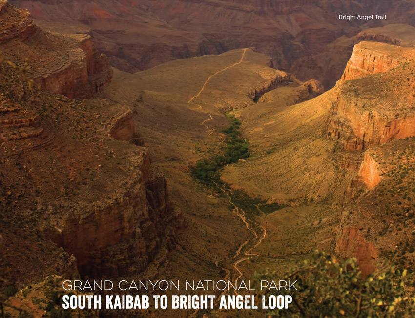
Trek to the bottom of the Grand Canyon on a shuttle hike that tours rugged canyons, visits the Colorado River, and features stunning cliffside views.
New to the Big Ditch and want to pack a weekend of adventure into one huge day? String together corridor and threshold trails on this view-filled hike into the guts of the canyon—with an option to bail out across the canyon's midsection. You'll have plenty of company at the start and end, but empty stretches on the Tonto Plateau and along the bottom offer ample breaks from crowds, NOTE: Don't attempt this hike in summer's heat, spring and fall are best.
Begin at dawn, descending on the South Kaibab Trail into the belly of the canyon. Fill bottles at the trailhead; it's the only reliable water until mile 8.7. Pass the informally named Ooh Aah Point at the 0.8-mile mark and scan northeast across the canyon to Zoroaster Temple; by now, morning light will bathe the Iconic, eroded spire. Continue switchbacking through off-white Coconino Sandstone and head north along Cedar Ridge through the Supai Group's blood-red shale. Wind behind 6,071-foot O'Neill Butte and drop 300 feet to the saddle below 5,210-foot Skeleton Point, where you'll hear the distant roar of the Colorado River flowing a half-mile below. Look up toward the north-northwest and you can see Natural Arch at the top of the butte. The trail travels across the Tlpoff, the trail's steepest section and the beginning the descent Into the Inner canyon. Here, buttes and points fan out In every direction. Continue straight on the South Kalbab Trail at the next two Intersections with Tonto West Trail and Tonto East Trail. Take your group's pulse: If you're feeling gassed, detour left at mile 8.4 to follow the Tonto Plateau onto the Bright Angel Trail and hike 0.3 mile to Indian Gardens. If you're feeling strong, continue to your first views of the Black Bridge spanning the Colorado River.
Soak up views of the Colorado River as you descend Into banks of otherworldly Vishnu schist—dark, green-black rocks shot with pink granite and other colors—that make up the basement of the canyon. Walk across Black Bridge. To the west, you can see the Silver Bridge, as well as Bright Angel Campground. Below, Whitewater rafters and kayakers take breaks on the beach next to the Colorado River. Follow the trail on the opposite side of the river to pass 800-year-old ruins along the banks. Turn left at a three-way Intersection to cross Silver Bridge. Potable water (seasonal) and a bathroom are available here. After the bridge crossing, turn right at the T Intersection. The sandy path ahead may slow your pace. Continue straight at a three-way Intersection on the Bright Angel Trail (the right trail leads down to the Pipe Creek Beach). Pass the River Resthouse and begin a steep climb up to Indian Gardens. Once there (the aforementioned bailout point), break creekslde In groves of cottonwoods and admire the vermllllon-streaked, cathedral-like walls. Tank up here before the 4.7-mile, 3,000-foot ascent to the rim.
Pace yourself on Jacob's Ladder, a set of steep switchbacks rising through the Redwall Formation between the 1.5-Mile and 3-Mile Resthouses. After nearly 12 hours of hiking, you'll reach the rim—just In time for victory steaks at the Bright Angel Lodge.
DISTANCE: 13.7 miles
TIME REQUIRED: 1 day
DIFFICULTY: Strenuous
CONTACT: Grand Canyon National Park, (928) 638-7875; nps.gov/grca
THE PAYOFF: This canyon classic packs park high-lights into one big day.
TRAILHEAD GPS: 36.0534096, -112.0835495
FINDING THE TRAILHEAD: From S. Lake Powell Boulevard and US 89 in Page, head southwest on US 89. In 81.5 miles, turn right onto AZ 64. In 53 miles, turn right onto S. Entrance Road. In 2.7 miles, turn left onto Village Loop Drive. In 0.2 mile, bear left at Village Loop Drive. In 0.2 mile, turn right to stay on Village Loop Drive. In 100 feet, turn left to stay on Village Loop Drive. Go 500 feet and park in Lot E at the South Rim Backcountry Information Center. Take a free shuttle bus to the trail head.
WAYPOINTS & DIRECTIONS
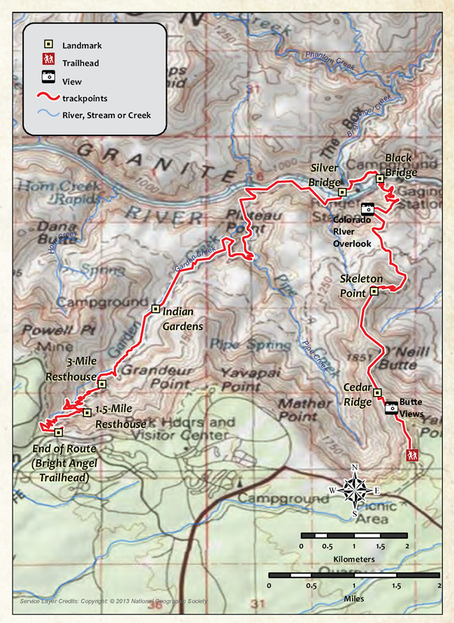
GPS: 36.053410, -112.083550 Head north from the South Kaibab trail head. From May to mid-October, fill water bottles at the spigot near the bus stop. Caution: There are no other water sources along the South Kaibab Trail.
GPS: 36.064053, -112.089485 Head north along Cedar Ridge, a wide ridge that resembles a plateau (stunning bird's-eye views of the canyon). There are established composting toilets here.
GPS: 36.081291, -112.089996 Skeleton Point, which offers the first views and sounds of the Colorado River. Look down to the east to see the numerous switchbacks ahead.
GPS: 36.085462, -112.086371 Look up toward the north-northwest and you can see Natural Arch at the top of the butte.
GPS: 36.090066, -112.088903 The trail travels across the Tipoff. (Note: There is a phone here that could be used in an emergency.) Continue straight on South Kaibab Trail at the next two intersections with Tonto West Trail and Tonto East Trail.
GPS: 36.096248, -112.086650 First views of Black Bridge, a suspension bridge over the Colorado. Look down on the series of switchbacks to come.
GPS: 36.099342, -112.088871 Stay right at Y Intersection on South Kaibab Trail as the River Trail enters on the left.
GPS: 36.100435, -112.089064 Walk across Black Bridge. To the west, you can see the Silver Bridge, as well as Bright Angel Campground. Below, Whitewater rafters and kayakers take breaks on the beach next to the Colorado.
GPS: 36.099842, -112.093971 The trail passes 800-year-old ruins along the banks of the Colorado. Turn left at three-way intersection to cross Silver Bridge.
GPS: 36.098122, -112.095406 Cross the Colorado River on the Silver Bridge, a suspension bridge with views of the raging water below. After the bridge crossing, turn right at the T Intersection.
GPS: 36.098541, -112.111748 Continue straight at three-way intersection on the Bright Angel Trail. Trail passes the River Resthouse and steeply climbs through the canyon up to Indian Gardens.
GPS: 36.081951, -112.124550 Continue straight on Bright Angel Trail at three-way intersection. Tonto East Trail enters on the left.
GPS: 36.065552, -112.136231 3-Mile Resthouse. Take a break at this shelter. (Note: Emergency phone available). Only three miles of trail remain to the South Rim. The route continues to climb up switchbacks; views extend into the canyon to Indian Gardens.
GPS: 36.060680, -112.138733 1.5-Mile Resthouse. There are two shelters here; one of them has potable water and a bathroom. Next, the trail continues to climb up switchbacks, but becomes noticeably flatter as it approaches the South Rim.
GPS: 36.057312, -112.143631 The route ends at the Bright Angel Trailhead.
The only thing you'll regret about taking the brood backpacking is not doing it sooner—and more often.
“How much farther?” It's a question young kids seem hardwired to ask, whether on a car ride or a hike. My kids were no different. All three boys started camping before they could talk, then backpacking as soon as they could walk, and I'm pretty sure that was one of their first sentences. But really, is there anything to be gained from telling the truth?
In my twenties, as a wilderness guide for teens, I developed an “educational” strategy to address this inevitable question, and I adopted the same policy with my kids, Milo, Zig, and Tate, from the outset: No matter where we were—a few minutes from the trailhead, a few minutes from camp, or anywhere in between—when they asked how much farther, I'd respond: “We're halfway.” Admittedly, that answer didn't always lead directly to smiles, and it probably delayed their grasp of distances by a couple of years. But early on, they learned to stop dwelling on when we'd “get there” and start enjoying the hiking part of backpacking, because that's the real hurdle with kids. (Playing in the dirt, climbing rocks, eating s'mores, and wrestling in a tent don't need a hard sell.) In the beginning, expect some trial and error. There were plenty of times that we started too late and found ourselves pleading with preschoolers—“Keep hiking, you can do it”—in order to make camp before dark. (Tip: There's no shame in candy bribes.) But mostly, it's just fun. All of it.
Case in point: On a weekend trip in Colorado's Indian Peaks Wilderness, we tackled a route that climbs about 2,000 feet in 3 miles. Milo, Zig, and Tate were 8, 6, and 4 years old at the time, and I expected them to poop out, well, about halfway up the steep trail. Instead, my wife, Jen, told a Batman story, the boys stopped to explore an abandoned silver mine, and we all took a break to throw rocks in a scree field. They were surprised when we arrived at the pass on the Continental Divide so “fast,” and ran down to the lake on the other side. Like true backpackers, they knew instinctively that the pine- and meadow-fringed basin was a magical place simply because we'd walked to it. That evening, a swirling, low-hanging cloud caught light from the setting sun and filled the cirque with a red glow. Moisture in the cloud reflected the light, so it felt like we were camping in the middle of an electric snow globe. Will they remember playing cards amid that otherworldly light? Doesn't matter. I'm convinced it left an imprint that will last a lifetime—on all of us.
“My pack's too heavy.” Not a surprising complaint from a 5-year-old. So when Tate announced that he couldn't carry his pack another step, I ignored him. We were hiking up a trail in the Rockies in October, amid aspens turned a dozen shades of gold. Jen, Milo, and Zig continued up the trail ahead of us, ascending along a creek. I slowed down and walked next to Tate, my youngest. I figured he was just tired from his school field trip. He had gone to a farm near Boulder, Colorado, where he and his classmates had been encouraged to pick all the potatoes, onions, carrots, turnips, and pumpkins they could carry. He came home dirty and exhausted but excited about his haul.
The next day, we had this season-ending weekend in the high country on the schedule. We performed the normal fire drill getting out the door, haranguing the kids to pack their gear. They've been responsible for getting their own stuff together since they could carry the smallest packs, starting with the little things—a book, a headlamp—and growing into the heavier items. We figure if they're responsible for packing, they can't complain about what they don't have. (Admittedly, the rule has resulted in a few missing items.) On this trip, Milo and Zig were responsible for all of their gear, and Tate, the kindergartner, was charged with carrying everything but his bag and pad. That's why I felt comfortable dismissing his whining. How heavy could a kid-size fleece and a comic book be?
But when he stopped to complain yet again, dropping his pack to the ground and leaning against a boulder to rest, I was torn. Like any parent who wants his kid to love the outdoors, I didn't want to let one moment undermine everything that had come before.
“Please,” he asked, “can you carry my pack for a little bit?”
“OK,” I relented, knowing we still had a couple of hours to go. “Just for a bit.” I reached down and grabbed the pack—and nearly lost my balance trying to lift it. “What in the world do you have in here?” I asked. “Just my pumpkin,” Tate answered, as if it was one of the 10 Essentials. Another reason to take your kids backpacking: You think you've seen it all, and then find yourself hanging a pumpkin in a bear bag.
Challenging kids—without pushing too hard—requires constant recalibration as they get older. You want to see them experience the triumph of achievement without overdoing the agony of defeat.
We had something like that in mind when we hiked to the bottom of the Grand Canyon for Christmas, a couple months after the pumpkin episode. Not surprisingly, the kids breezed down the South Kaibab Trail, gaping over the views and the trailside drops. We pitched our tinsel-draped tent at Bright Angel campground, where a ranger convinced the boys that a satellite passing overhead was Santa's sleigh, and we joined a group of carolers at Phantom Ranch. Mission accomplished? Not quite.
As every Grand Canyon hiker knows, getting in is the easy part. On the hike out, along the Bright Angel Trail, the boys slowed to a snail's pace. Every time they looked at the rim far, far above, they might as well have been contemplating the moon. Tate needed more superhero stories per mile than usual. But their little legs kept churning away. Over two days, we inched our way upward, and they started hiking stronger as the inner gorge receded below. And thanks to backpacking, we experienced another parenting moment that's hard to beat: when your kids have every right to complain but don't.
We were nearly at the top when we passed an older hiker, perhaps in this sixties, bent under a heavy load, resting beside the trail. “How much farther do you think it is?” he asked as we passed.
“Looks like we're about halfway,” Milo responded, without hesitation.
I couldn't have been more proud.
—Dennis Lewon