Tour glacial valleys and navigate to off-trail lakes and waterfalls on this 6-day circuit.
Want to see classic Rocky Mountain National Park landmarks and explore hidden pockets of wilderness? Do it on this 54-mile, best-of-both-worlds trek that crisscrosses the Continental Divide, linking the park's lesser-tracked high country west of the Divide with the well-loved lakes and waterfalls on the east side.
Start on the East Inlet Trail, roughly 2 miles from the town of Grand Lake, and hike east along its meandering namesake creek. Less than 0.5 mile in, take the quick 0.2-mile loop on the right to see Adams Falls, which cascades down boulders and plummets through a narrow gorge. As the trail runs up the valley, you'll skirt marshy meadows (look for moose munching in the willows in early morning) and meander through lodgepole pine and quaking aspen groves.
Five miles in, trace the southern shoreline of Lone Pine Lake, a forested pool protected by a cluster of 12,000-foot peaks, and climb east toward the head of the pinched valley. Pick up the user path at mile 6.4, where the maintained trail ends at Lake Verna, and follow it past Spirit and Fourth Lakes. From there, tackle a steep bushwhack, gaining 1,600 feet in 0.9 mile, to wind-blown 12,061-foot Boulder-Grand Pass on the crest of the Continental Divide.
Descend talus-filled gullies on the east side of the Divide and connect with the maintained trail at Thunder Lake; camp in the designated site just north of the lake.
Rise early on day two for a strenuous day of high-altitude cross-country travel that racks up 6,200 feet of elevation change in less than 5 miles. Leave the established trail 0.2 mile east of the Thunder Lake patrol cabin and navigate north past your own private waterfall—watch misty Thunder Falls pour down a short cliff, then flow through a streambed of boulders.
About half an hour from the Thunder Lake Camp, cross the Lion Lake Trail in a spongy meadow and veer east to the granite-lined banks of Castle Lake, one of the most isolated in the park, with prime northwest views of Mount Alice's crags. Next, climb northeast above treeline to a broad, flat saddle on North Ridge, then descend the backside, crossing Hunters Creek at the outlet of a small pond below Keplinger Lake.
Past the lake, maneuver around boulders and bushwhack through stunted trees near the timberline to the base of Keplinger's Couloir on Longs Peak's south face (mile 13). Scramble up the couloir to about 13,500 feet, and traverse northwest on a rock ramp that leads to the 3-foot-wide Narrows ledge. (Don't miss: Scale the cracked granite slabs that rise 450 vertical feet directly in front of you to tag Longs Peak's summit on a 0.1-mile roundtrip detour.)
Tightrope walk west, then downclimb boulders in the Trough couloir, angling north at 13,200 feet for a 0.3-mile traverse to the Keyhole notch and the Boulder Field. Sleep above treeline in one of nine campsites.
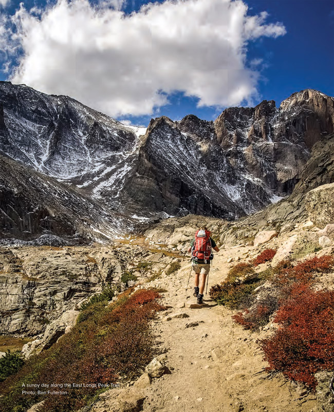
On day three, descend East Longs Peak Trail, and swing left at mile 20 near the park's eastern boundary to crest Storm Pass and the 11,006-foot pinnacle of Estes Cone. Descend 2.9 miles and spend the third night near beaver ponds at Upper Wind River Campsite.
Day four: Drop into Glacier Basin, and turn left at mile 30, passing the popular Alberta Falls (crowds fade ahead). Less than 1 mile later, turn right at the base of Glacier Knobs, two side-by-side granite domes, and skirt the north shore of the Loch, rimmed by cliffy, granite peaks. Pitch your tent 0.2 mile later in a spruce-fir stand at Andrews Creek Camp.
Hike past Chaos Canyon, Tyndall Gorge, and three more lakes (Dream, Nymph, and Bear) on day five. The last major climb (gaining 2,800 feet in 4 miles) starts at mile 37.7 from the eastern shores of Bear Lake and ascends steadily through shady spruce, fir, and aspen stands. Stop at an overlook midway up a series of tight switchbacks to peer into the depths of Tyndall Gorge; Tyndall Glacier, one of the park's most photographed, sits at the head of the cirque.
Near mile 42, you'll roll across 12,324-foot Flattop Mountain, a broad swath of alpine tundra where you're almost guaranteed the chance to hang with elk. Descend west to pick up North Inlet Trail at a three-way junction, and drop down 3.3 miles to the July Campsite near Hallett Creek. Close out the week with an 8.4-mile descent along North Inlet Creek to your car.
Only have a long weekend? Do an abbreviated version this loop over the Continental Divide by following the Tonahutu Creek Trail to Grand Lake and returning over Flattop Mountain via the North Inlet Trail, following creeks to a long alpine tundra traverse. In autumn, the forest floor beside the trail is covered with a golden carpet of bearberry and other ground cover. Allow 3 to 4 days to make the most of this superb, 34-mile tour of the west side. Get an early start over Flattop in both directions—you're exposed to severe weather for several miles above the treeline.
DISTANCE: 54 miles
TIME REQUIRED: 6 day
DIFFICULTY: Strenuous
CONTACT: Rocky Mountain National Park, (970) 586-1206; nps.gov/romo
THE PAYOFF: Link classic spots with empty wilderness.
TRAILHEAD GPS: 40.239406, -105.799839
FINDING THE TRAILHEAD: From Trail Ridge Road and W. Portal Road in Grand Lake, drive 1.1 miles northeast on W. Portal Road. Turn left on CR 663. Go 0.3 mile to the parking area and drop your shuttle car. Take CR 663 back to W. Portal Road and turn left. Drive southeast 1.2 miles to the East Inlet parking area.
WAYPOINTS & DIRECTIONS
GPS: 40.239406, -105.799839 Hike southeast on the East Inlet Trail from the trailhead at the eastern edge of Grand Lake.
GPS: 40.237117, -105.797497 Turn right onto the short loop trail that leads to a viewing platform near Adams Falls before continuing on the main trail.
GPS: 40.227416, -105.712144 Lake Verna. This long, whale-shaped lake has a sandy beach on its east shores. The maintained trail ends here; follow the path that runs along the northern shore of the lake.
GPS: 40.222993, -105.685043 At the northeast edge of Fourth Lake, start a steep bushwhack, next to a tiny creek, that ends on Boulder-Grand Pass.
GPS: 40.224795, -105.673456 Hike through grass hummocks in this shallow, wet gully near treeline. The remaining stretch across tundra to the pass (directly east of this point) is obvious from here.
GPS: 40.224631, -105.669100 Crest the wind-blown Boulder-Grand Pass, which links the East Inlet valley and Wild Basin.
GPS: 40.224664, -105.668628 Descend this gully (bypassing the permanent snowfield on the east side of the pass) to the banks of Lake of Many Winds.
GPS: 40.225376, -105.665731 This aptly named lake is perched on a gusty bench below Boulder-Grand Pass. From here, descend a boulder-filled gully paralleling the outlet stream to reach the north side of Thunder Lake.
GPS: 40.222305, -105.644982 Pass the Park Service patrol cabin, then turn left at the side trail to the forested Thunder Lake Campsites to camp the first night.
GPS: 40.221797, -105.641828 On the second day, the route leaves Thunder Lake Trail. Bear left (north) at this point (0.2 mile east of the lake) for a cross-country climb that passes Thunder Falls.
GPS: 40.229480, -105.637901 About 30 minutes from the Thunder Lake Campsite, you'll cross the Lion Lake Trail in a wet meadow. Continue cross-country, heading southeast to lily-pad-shaped Castle Lake.
GPS: 40.228983, -105.635058 Scramble through the gap in a small cliff band to reach Castle Lake.
GPS: 40.229022, -105.634747 Granite-lined Castle Lake offers prime views of Mount Alice's east face. From here, skirt the southern edge of the lake, then climb northeast to the broad, flat saddle on North Ridge.
GPS: 40.230571, -105.627141 The climb tops out above the treeline on North Ridge, which forms the southern slopes of Chiefs Head Peak. Next, descend North Ridge, heading north to the small pond below Keplinger Lake.
GPS: 40.235328, -105.626078 Cross Hunters Creek at the outlet of this small pond below Keplinger Lake. Next, climb northeast into the gully adjacent to the Keplinger Lake drainage (Note: It's tough going ahead through boulders and krummholz for about 0.5 mile.)
GPS: 40.247971, -105.616901 This point marks the entrance to Keplingers Couloir, the gully splitting the south face of Longs Peak. Keep climbing.
GPS: 40.249939, -105.616486 The gully forks here: stay left.
GPS: 40.253148, -105.614512 Below the Notch, follow a wide rock ramp to the northwest to reach the Homestretch.
GPS: 40.253656, -105.614877 Follow the ledges to the left (west) below the Notch here.
GPS: 40.254049, -105.616980 East end of the Narrows. The route traverses west along more exposed ledges.

GPS: 40.254393, -105.618718 Top of the Trough, a huge northwest-facing couloir. Watch for icy snow patches. From here, it's a 6-mile descent toward the Longs Peak trailhead.
GPS: 40.256211, -105.620670 Bear right (north) to exit the Trough. Traverse the boulder-covered slopes toward the Keyhole.
GPS: 40.260485, -105.621271 Arrive at the Keyhole, a huge rock notch that rises above the Boulder Field. (CAUTION: Follow blazes to avoid cutting east too soon and cliffing out on the False Keyhole.) Ahead, pass a small stone building, then carefully descend the Boulder Field.
GPS: 40.263481, -105.615435 Spend the second night above treeline at the Boulder Field Campsite (nine individual sites). On day three, continue descending East Longs Peak Trail.
GPS: 40.274089, -105.605403 At wind-swept Granite Pass, turn right, heading south. Continue straight at the next three-way junction.
GPS: 40.265675, -105.592732 Turn left at the threeway junction on Mills Moraine.
GPS: 40.275007, -105.564280 Turn left at the threeway junction, heading north toward Storm Pass.
GPS: 40.286978, -105.564742 Turn left at T junction.
GPS: 40.293051, -105.573711 Crest forested Storm Pass, then turn right for a short, steep ascent of mounded, 11,006-foot Estes Cone.
GPS: 40.294306, -105.570867 Caution: Rocky trail switchbacks at odd places. Watch for random cairns.
GPS: 40.295292, -105.567398 Estes Cone (11,006 feet). The Summit serves up views of dozens of snowy peaks, including Mount Meeker and Longs Peak. Return to Storm Pass and bear right on Storm Pass Trail
GPS: 40.311284, -105.606916 Turn right on Wind River Trail to reach the night's campsite.
GPS: 40.312336, -105.600044 Spend the third night at Upper Wind River Campsite, marked with a silver metal arrowhead. The two sites are near beaver ponds in a lodgepole pine forest. On day four, backtrack to where you turned onto the Wind River Trail, turn right, and descend Storm Pass Trail into Glacier Basin.
GPS: 40.314936, -105.612076 Turn left at the threeway junction with Glacier Creek Trail.
GPS: 40.316791, -105.615717 Continue straight (west) at the intersection with Boulder Brook Trail. The trail climbs moderately for the next 5.1 miles to Chaos Creek.
GPS: 40.307678, -105.643402 Turn left at the threeway Glacier Gorge Junction. The trail climbs southeast toward Alberta Falls.
GPS: 40.306206, -105.638908 A few user-created trails lead to the edge of a deep ravine.
GPS: 40.299625, -105.639596 Admire the valley views at the rest stop just before the three-way junction. Turn right. The trail skirts the base of the Glacier Knobs.
LOCATION: 40.297412, -105.645948 Continue straight at the junction located between Glacier Knobs, two side-by-side granite domes. Head southwest into Loch Vale.
GPS: 40.287890, -105.664347 After crossing Andrews Creek, turn right at the Y junction.
GPS: 40.289445, -105.666976 Night four: Set up your tent at Andrews Creek (one individual site) in a spruce and fir stand. On day five, backtrack to the junction between Glacier Knobs, and turn left (north) onto the Glacier Gorge Trail.
GPS: 40.305189, -105.656707 Cross Chaos Creek, which flows out of Lake Haiyaha at the mouth of Chaos Canyon.
GPS: 40.308549, -105.658340 The trail switchbacks to the right and runs along the southern shore of skinny Dream Lake.
GPS: 40.311996, -105.646291 Pass Bear Lake trailhead, then head north toward Bear Lake for the last big climb of the route to 12,324-foot Flattop Mountain.
GPS: 40.313522, -105.646856 Turn right at three-way junction onto the Flattop Mountain Trail, and begin a steady ascent through a thick conifer forest intermixed with spruce-fir and aspen stands.
GPS: 40.317278, -105.644428 Turn left onto the Flat Top Mountain Trail at the three-way junction.
GPS: 40.316422, -105.653051 Bear left at the threeway junction and continue ascending through the trees.
GPS: 40.315211, -105.665442 As the forest thins, make sure to evaluate the weather before continuing on. During summer months, afternoon lightning storms can hit quickly.
GPS: 40.310348, -105.684187 Just below the Flattop summit, pass a large hitch rack marking the top of Tyndall Glacier, which can be seen to the east. The trail quickly ascends the last few hundred feet to the large flat summit of Flattop Mountain.
GPS: 40.308854, -105.690300 Crest Flattop Mountain (12,324 feet). The summit, largely a flat swath of alpine tundra, has no official summit marker, but hikers generally consider the junction of Flattop Mountain Trail and Tonahutu Trail the top. To continue, descend the Tonahutu Trail toward Ptarmigan Pass.
GPS: 40.309534, -105.694771 Turn left onto North Inlet Trail at this three-way junction. The trail descends south past knee-high cairns with eastern views of Longs Peak.
GPS: 40.286761, -105.702810 Cross Hallett Creek. Spend the fifth night at the July campsite (three individual and one group sites). A bear box is available directly uphill.
GPS: 40.282450, -105.715351 Descend exposed switchbacks.
GPS: 40.281300, -105.721220 Continue straight at this junction with the Lake Nanita Trail.
GPS: 40.271441, -105.766538 Arrive at Cascade Falls. A spur trail full of roots and rocks shoots off to the right and brings hikers to the base of the falls.
GPS: 40.256558, -105.814764 The route ends at the North Inlet trailhead on Rocky Mountain National Park's less-trafficked west side. Pick up your shuttle car and follow Summerland Park and West Portal Roads to the East Inlet trailhead.