These 10 miles of pure Alaska experience are among the best 100 miles of trail in the whole national park system. The catch: It's barely a trail.
How did we zero in on just 16 miles of trail in the 13.2 million acres encompassed by the biggest, wildest park in the entire national park system? It's partly a technicality: Actual trails are hard to come by in Wrangell-St. Elias (and in truth, the aptly named Goat Trail is still only sort of a path). But mostly, it's because this chunk of tundra where the Wrangell and St. Elias Ranges meet is raw Alaska at its finest. On this highflying variation, you'll get all the scenic highlights while avoiding the alder thickets and potentially dangerous river fords of lower Chitistone Gorge. The route passes waterfalls, skirts enormous moraines, and plunges into a deep gorge. Allow at least 5 days in case of weather delays—and for excellent detour hikes, like a circumnavigation of Wolverine Mesa, or exploring around Chitistone Pass and the Skolai Lakes.
Reaching this primo stretch requires taking a bush plane to the Wolverine Airstrip, then hiking miles of forest and canyon plus making several dicey river crossings. From Wolverine landing strip, keep an eye on your footing as you cross a massive talus slope to the northeast—it's easy to be distracted by the Twaharpies, giant peaks across Chitistone Gorge that rise 10,500 feet. After 2.5 miles, the wildlife track you've been following vanishes in the tundra around Hasen Creek. You won't see established track again until you hit the Goat Trail at mile 9.8.
Cross Hasen Creek where it splits into upper tributaries, and continue northeast up gradual tundra benches, passing two massive waterfalls that thunder just to your right.
Above the waterfalls, cross upper Hasen Creek, then veer right (east) through a broad, meadowy pass. Stay left (north) as needed to avoid swampy areas, but stay on tundra and don't wander too far north onto glacial moraine as you round the headwaters of the Chitistone River's western fork, aiming for the lowest, farthest toe of an obvious, massive moraine about 2 miles away.
Round the moraine toe as closely as possible to avoid cliffs in the streambed below. As you walk, look right (southeast) toward the craggy ridgeline ahead, which descends southward off of Point 7,755. You'll need to cross this ridge on the obvious grassy bench that sits roughly across from you and slightly below, at around 5,500 feet elevation. From the moraine toe, descend on a gradual traverse along the eastern margin of the stream gorge. You'll drop almost 300 feet before you can gain the tundra bench at ridgeline, which is the gateway to the Goat Trail, renowned for its narrow, exposed track that cuts across exposed talus.
Here's where the fun really begins: The route follows a path literally worn by Dall sheep and picks its way across a ketchup-and-mustard-striped cliff band of crumbly limestone for 1 mile. Scout carefully for the real trail, following one of the hoof-made spurs too far can cliff you out. Caution: Do not descend into the darker greenish rocks or you'll wander into dangerous, exposed cliff bands. On the Goat Trail, you'll traverse nearly 1 mile of steep talus, and then descend another 1,000 feet to the Chitistone River. On calm days, you can hear the roar of 400-foot Chitistone Falls, not far downcanyon from your route.
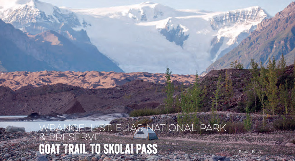
Once across, follow the Chitistone River northeast. Stay on the west side of the river, following patchy trail across several stream crossings, all the way to broad Chitistone Pass at 5,800 feet of elevation. Here you'll spill out onto the spongy tundra of Chitistone Pass, where forget-me-nots and moss campion bloom under nameless, glacier-crusted peaks and, on a clear day, the views stretch deep into the colossal University Range. As you crest the northern side of the 3-mile-long pass, the Russell Glacier comes into view like a 20-mile-long, 2-mile-wide tongue unfurling from 16,421-foot Mount Bona. From there, you'll drop another 2 miles to Skolai Pass. Here the track takes a 180-hairpin turn left (west) at the brink, then becomes very faint. Search closely for a way down through the cliffs. Once you're spit out at the base of the long ridgeline after a 1,300-foot descent down cliff bands and steep slopes, follow it left (west) for 2.5 miles to the small, grassy Lower Skolai Lake Airstrip, which is just above the southwest shore of Lower Skolai Lake. Keep your eyes peeled for grizzlies, caribou herds, and the occasional wolf before meeting your plane. Congratulations, you've just punched your Alaska hiking card in a big, big way.
DISTANCE: 16 miles
TIME REQUIRED: 5–7 days
DIFFICULTY: Expert
CONTACT: Wrangell-St. Elias National Park and Preserve, (907) 554-1105; nps.gov/wrst
THE PAYOFF: Pure Alaska.
TRAILHEAD GPS: 61.508746, -142.299173
FINDING THE TRAILHEAD: Flights to the Wolverine Airstrip start in McCarthy, reached from Chitina via a rough 60-mile dirt road. (Flights: wrangell-mountainair.com)
WAYPOINTS & DIRECTIONS

GPS: 61.509413, -142.296256 The bush plane will drop you off at the Wolverine Airstrip; from here, hike north across a talus slope.
GPS: 61.527919, -142.294149 Head northeast.
GPS: 61.529459, -142.290843 Stay above cliff bands.
GPS: 61.532520, -142.286465 Hike north.
GPS: 61.541957, -142.293959 Good campsite.
GPS: 61.542745, -142.296211 Veer right and begin to descend.
GPS: 61.553739, -142.292352 Cross the western tributary of Hasen Creek, then climb the dirt ridge between the tributaries and continue north.
GPS: 61.567632, -142.248909 Veer right (east) through pass. Stay on tundra, but track north as needed to avoid swampy areas.
GPS: 61.566168, -142.211676 Good campsite.
GPS: 61.565046, -142.205184 Round moraine toe as closely as possible.
GPS: 61.553102, -142.187417 Goat Trail. Cross the ridge as high as possible in light yellowish talus, avoiding the darker green band on a trail worn by Dall sheep. After traversing talus, descend 1,000 feet to the Chitistone River.
GPS: 61.560160, -142.159567 Stay on Goat Trail on the west side of the Chitistone River.
GPS: 61.575198, -142.122145 Trail swings up to cross stream.
GPS: 61.590311, -142.072535 Continue north; pass tarn ahead.
GPS: 61.605825, -142.057772 Chitistone Pass.
GPS: 61.615303, -142.023027 Drop down through cliff band, cutting northwest to the shore of Lake Skolai.
GPS: 61.629210, -142.077894 Lower Skolai Lake Airstrip.
GPS: 61.630721, -142.010519 (Caution: This landing strip on the other side of the lake is no longer operational.)

Learn how to discern the markings on your two-dimensional map.
CONTOUR LINES Each thin, brown line represents a single elevation. Check the bottom corner of your map for the contour interval, which tells you how many vertical feet apart they are from one another (usually 40 feet). Index lines, which are thicker, are labeled with the elevation in feet.
A. STEEP TERRAIN
Crowded sections of contour lines
B. GRADUAL TERRAIN
Spacious sections of contour lines
C.GULLY
V-shaped contour lines “point” toward higher elevations
D. RIDGE
V-shaped contour lines “point” to lower elevations
E. CLIFF
Super-concentrated lines
F. TRAIL
Black, dashed line
G. SWITCHBACKS
Zigzagging trail
H. DIRT ROAD
Black dashed double line
I. RAILROAD TRACKS
Solid black line with hatch marks
J. STREAM
Solid blue line
K. WATERFALL
Single blue hatch intersecting a stream
L. SUMMIT
Contour line forms a small circle

Liz Thomas has backpacked more than 15,000 miles, and she holds the women's unsupported speed record on the Appalachian Trail (80 days). Here are her top ways to stay on track.
1. Keep your mind and body sharp. It's really hard to navigate if you're hungry, thirsty, or cold. “An unfueled brain is more likely to make poor decisions,” Thomas says.
2. Confirm your location on your map often. Sounds obvious, but this is the single best way to prevent wandering off course. “I hike with a map in my hand, pocket, or—a little embarrassingly—stuffed in my bra,” Thomas says.
3. Learn to read contour lines. GPS units are great, but you still need to be able to read a map. That means understanding how contour lines represent real-world terrain. An activity to get you started: Make a fist into “Knuckle Mountains.” Draw a circle around each peak, or knuckle, keeping your pen at the same “elevation” as you draw each line. Moving down from your knuckles, draw concentric circles around your fist, about a half-inch apart. Flatten your hand: The lines represent different “elevations” on the topographic map of your fist Knuckle Mountains.
• CONTOUR LINE. The closer the lines, the steeper the terrain. Check your map for the contour interval (the elevation change between lines).
• SADDLE, indicated by opposing Us.
• PEAK. The bulls-eye circle in the middle of concentric rings.
• DRAINAGE OR VALLEY, with the Us (or Vs) pointing the same direction, uphill. Ridges look similar, with the Vs pointing the same direction, but they face downhill.
• SEE PAGE 335 for tips on identifying other common features.
4. Learn the difference between true north and magnetic north. A compass needle points to magnetic north. That's not the same as true north (the North Pole, or the direction of the North Star). The difference between true north and magnetic north is called declination; it changes over time (as the Earth's magnetic field shifts), and it varies according to your location (see below). Learn how to account for it at backpacker.com/declination.

5. Think like a railroad builder. Traveling cross-country? Observe the landscape and imagine, “If I were a railroad engineer, where would I build the line?” You will likely choose the path of least resistance.
6. Use nature's bumper lanes. Ridges, rivers, and prominent peaks can all serve as route boundaries. Pay attention to the terrain that borders your route, and use landmarks to avoid going astray.
7. Avoid shortcuts. Not only does cutting switchbacks or taking shortcuts cause erosion, it's also an easy way to get lost.
8. Enter the right datum in your GPS.
Technology is great—if you use it correctly. The most common GPS error: Failing to match datums, the systems used to match features on the ground to coordinates on the map. For Example, a WGS 84 coordinate taken from Google Earth and entered into a GPS set to NAD 27 can be up to a quarter-mile off.