CONTENTS
Stonehenge, Amesbury, Wiltshire
| LATITUDE : 51° 10′ 43.87″ N | LONGITUDE : 1° 49′ 34.27″ W |
Stonehenge is to be found in southern England on Salisbury Plain in Wiltshire. Salisbury Plain was clearly an extremely important ritual landscape for many centuries and a visit to Stonehenge also offers the opportunity to take in an impressive cross-section of prehistoric structures in a relatively small area.
Those who have not visited Stonehenge before, but who have been brought up on photographs or film of the structure, are often quite surprised when they actually view it for the first time. Set amidst such a wide and flat landscape, and especially viewed first from a distance, they often report that it is smaller than they expected. But once the edifice is approached on foot and seen close up, its impressive nature becomes immediately obvious.
The British Isles are filled with standing stones and stone circles but there is nothing quite like Stonehenge to be seen anywhere else. Here, the Megalithic art was brought to its zenith in a complex monument that spanned over 2,000 years and which was altered and refined on several occasions.
The Building of a Henge
Around 3100 BC people in the area decided to build a henge – a circular ditch and bank with two entrances, though even this was slightly different from henges that were being constructed in other parts of the British Isles at the same time. At Stonehenge the ditch is on the outside of the bank, as might be expected in a defensive structure, whereas true henges have their ditches on the inside of the bank. This henge is around 300 metres in circumference and at more or less the same time as it was constructed the Aubrey Holes came into existence. The Aubrey Holes comprise 56 chalk-filled pits, each about a metre across and arranged in a circle just inside the henge. It is thought unlikely that they ever contained wooden posts and their purpose has always been something of a mystery. It has been suggested that they were used as a sort of calculator or prehistoric computer, in order to calculate some of the longer lunar cycles – and possibly eclipse cycles. If this is the case, coloured stones could have been placed in the pits and moved at regular and prescribed intervals. The theory is fascinating but remains in doubt in the minds of many experts. It is generally accepted that after the construction of the henge and the Aubrey Holes (incidentally named after John Aubrey, a 17th-century antiquarian, pseudo-historian and self-styled Druid), the site was abandoned for about a thousand years. What this broadly means is that no datable evidence has been found that covers the period, but that may not be surprising because few henges reveal all that much in the way of datable evidence. It is true that this could be because the site remained unused, but could equally be a reflection of the fact that it was only used for ritual purposes and perhaps only on a few occasions during the year.
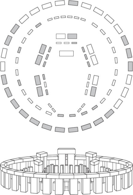
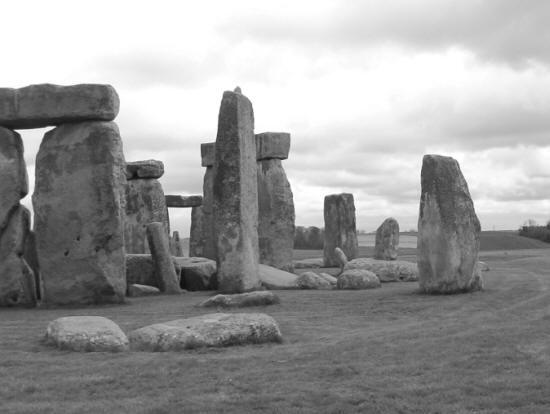
Figure 28: Stonehenge is the only standing stone circle in the British Isles with cross stones above its uprights
Welsh Bluestones
Whether or not the site was truly abandoned for a millennium, around 2150 BC something dramatic took place at Stonehenge. Around 82 stones were brought to the henge and erected in an incomplete double circle – more like a giant horseshoe in a way. What makes this part of the Stonehenge story quite remarkable is where these stones – known as bluestones – actually came from. It is now generally accepted that they came from the Preseli Mountains in South Wales, a location 143 miles (230km) away to the west. Clearly disbelieving that stones, some of which weigh as much as 4 tonnes, could have been brought such a vast distance, people suggested for decades that the bluestones may have been brought to Salisbury Plain by glacial action in the remote past. This suggestion has now been cast into doubt and it does look as though each and every stone was hauled down from its mountain, carried on rafts along the south coast of Wales, before being brought by the River Avon and then the Frome, to be finally hauled overland to the site of Stonehenge.
Why on earth would anyone have gone to such tremendous trouble to obtain stone when there was plenty to be had on and not far from Salisbury Plain? It remains one of Stonehenge’s most enigmatic mysteries. The bluestones are dwarfed by the later sarsen stones but their quarrying and transportation surely ranks as one of the wonders of the Megalithic period. It is known that they were brought to the site in a fairly rough state and then beaten into shape using stone mauls because chippings of the bluestones have been found on site.
At this time the entrance to the henge was widened and a couple of other stones were erected. These are known as ‘heel stones’. Stonehenge would eventually be approached by a wide ‘avenue’ or ceremonial route and the first part of this was completed at the same time as the bluestones were erected.
Bigger and Bigger
About a century and a half later the site underwent another great transformation. Around 2100 BC huge stones were brought from the Marlborough Downs, about 25 miles away, and the Stonehenge we all know today began to take shape. The largest of the sarsen stones weighs around 50 tonnes, so although the journey they took to Stonehenge was significantly shorter than the one enjoyed by the bluestones, the feat was none the less impressive. It must have taken great ingenuity, not to mention a massive amount of muscle power, to drag such huge stones across an undulating landscape, though this pales into insignificance at the thought of not only standing some of them upright, but managing to balance other, equally massive stones, on top.
Figure 29: Stonehenge from the air (above), and reconstructed (below). In the aerial view, grey stones mark those still present, and white stones show where originals once stood.
Once again the stones underwent a great deal of preparation both before they began their journey and again when on site. They had to be pounded into shape and this time they were carefully designed with pegs and sockets so that a continual run of stones could sit on top of the outer circle and also on top of the horseshoe of five so-called trilithons nearer the centre of the henge.
Finally, around 1500 BC , the position of the bluestones was altered. They were made into a circle, with another horseshoe within the trilithons, creating the monument which, allowing for wear and tear and the great passage of time, is what we see at the site today.
The Ultimate Purpose
So, what was the purpose of Stonehenge? Why was it revered and altered over such a long period of time, and why should prehistoric farmers, most of whom would be struggling to stay alive through at least some parts of the year, invest so much time and effort into something that offered them nothing concrete in return? It’s a fair question, but one might just as well ask why the poor citizens of the small village of Southwell in Nottinghamshire should have taken it upon themselves to build one of the finest cathedrals in Britain during the Middle Ages? After all, most of those who built the great gothic masterpieces were living in squalid little dwellings and eking out the best existence they could under difficult circumstances. What on earth did they want with a massive and generally useless cathedral?
It is a fact that can be observed all over the world that human beings will do wonderful things and sacrifice almost anything for the sake of ‘belief’. The same was surely just as true for the Bronze Age farmers of the British Isles as it was for the peasants of Egypt or those living in pre-Columbian America – societies that created massive and enduring pyramids. Undoubtedly then, at the back of those who carefully planned and executed the various stages of Stonehenge’s development lay a need to placate and worship gods and goddesses. True, we don’t know much about the deities, or what practices were expected to keep them happy, but the thought of Stonehenge without a deep and abiding belief in a religion of some sort is plainly ridiculous.
Is Stonehenge an Observatory?
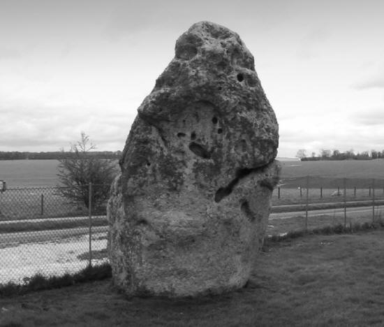
There have been many commentators over the years who have suggested that Stonehenge is actually a working astronomical observatory, and that it was used exclusively for tracking the Sun, Moon, planets and stars on their journeys around the sky. Certainly there seems to have been a very definite fascination for the winter and summer solstice, as well as the spring and autumn equinoxes. I, for one, think it certain that this was the case. I have shown, together with my colleague Christopher Knight, that the henges, long before any stones were erected on the sites, were naked-eye observatories of tremendous power and potential, as well as being recreations of certain parts of the observable sky translated onto the ground. If the bare henges allowed ‘experimentation’ (because moveable wooden stakes could be used instead of permanent stones, in order to learn about the heavens) then the finished stone circles were all ‘fixed’ observatories, where the foresights and backsights of specific stones and markers on the horizon allowed known and repeatable events in the heavens to be tracked on a regular basis in that geographical location. (The presence of outlying stones at Stonehenge, such as the Sentinel stone bears this out.)
The idea that science exists as a distinct and quite separate subject, totally divorced from religion and superstition, is very new indeed. Apart from a brief flirtation with logic during the ancient Greek period, in the main a consideration of the natural universe as distinct from the will of the gods was not really considered until the age of the European Renaissance. So, throughout most of human history, science and religion went hand in hand. In other words, to fully understand the pattern of the changing seasons or to comprehend the complex interplay of planets and stars were merely ways of getting into the minds of the gods.
Figure 30: The so-called Sentinel, an outlying stone close to Stonehenge standing stone circle
Christianity was no different, and did not willingly relinquish its hold on a large section of humanity until it was forced to do so by the arrival of the age of reason. It is therefore surely preposterous to see Stonehenge or indeed any of the other henges, circles or tombs as being places of religion or places of observable science – they were obviously both!
Controlling the Population
Just as an example, working out when a solar eclipse is likely to take place is a complicated business. It was attempted in ancient times, sometimes with great success and for a very sensible reason. People have always been fascinated by the sight of the Sun being swallowed by some unseen monster. In addition to this fascination, and in the absence of knowing what was really taking place, they were probably also terrified by such events for most of our history as a species. After all, nobody expects a cloudless world to suddenly go pitch black in the middle of a bright and sunny day. This can only be the work of the gods! Anyone who can predict when such a horrifying display is likely to take place is clearly very special, and probably in direct communication with the deity – or at least that’s how it would look to the ignorant majority. Knowledge is power. Put at its simplest, I say to a fairly primitive community with little mathematical or astronomical knowledge: ‘The Sun is going to be swallowed tomorrow. I will make it happen because I know God well. But don’t worry, because I will make sure that the Sun shines again.’ Everyone in the community turns out and, sure enough, the sky goes as dark as night and then, after a few minutes, light floods again into the world. What a powerful person I am and this little demonstration should make sure that everyone does more or less exactly what I tell them to do for the foreseeable future.
I might decide to create a machine that will make future predictions of eclipses more certain and accurate. So, whilst the fear is still upon them, I convince my fellow prehistoric farmers to build the machine I design. Of course they don’t know it’s a machine – to them it’s a sort of temple, a place where the gods and goddesses of nature are worshipped at certain parts of the year. The effort of creating the machine builds social cohesion, and it can take place in the winter, when there isn’t much to be done on the farm and when physical effort keeps people warm and more cheerful. Everyone wins – but of course I win most of all because I get my eclipse calculator, making my future predictions more certain and further increasing my power in the community.
This is just a single example. By putting stones in the right place I can ensure that the rising Sun at the time of the shortest day of the year (the winter solstice) emerges from the horizon and climbs up the northern side of a stone, strategically placed for the purpose. I tell everyone that the rising Sun will go no further south than this – that the days will get no shorter and that thanks to my intervention and my relationship with the gods, the Sun will now start to move north along the horizon at dawn, bringing warmer days and fruitfulness to the land. This is only one of a thousand tricks I can accomplish once I learn the natural patterns of the sky and the seasons, and I have plenty of time to do so because I am now a specialist. I don’t have to work long hours every day tilling land and planting crops. I am held in such reverence and awe that people for miles around are more than willing to cater for my every need, just so I can concentrate on being close to the gods. I have become a priest – the forerunner of every shaman and ultimately clergyman that has inhabited human societies.
So, how did I learn all of this in the first place? I inherited the knowledge from other priests who had spent generations at the henges, placing and replacing wooden poles around the bank tops, measuring angles and defining planetary cycles, until I was confident enough to make my observatory into something much more durable than wooden poles – I could build it in stone.
This is surely the story of Stonehenge. As knowledge grew, power also grew amongst the priestly class. Cultures came and went, influencing local populations and slowly changing belief patterns, but the priests remained. The more they understood, the greater the power they had over society and the more they could push for ever more grandiose monuments, for both observation and worship. It’s all a little simplistic, but I’m sure you get the picture. I don’t really see how the fantastic evolution of a site such as Stonehenge can be interpreted in any other way. The population of the British Isles at the time of the Megalithic era was incredibly small. Farmers might have some time on their hands in winter, but they could surely find better things to do with it than to risk injury or death dragging massive stones around the landscape.
Rites of Passage
On the other hand, what of rites of passage? Might not these almost superhuman feats of strength and endurance have been a very real part of the culture that created the henges and stone circles? Perhaps a boy could not truly become a man until he had taken part in the epic journey to Wales to collect a bluestone or until he had helped to haul a massive sarsen stone upright.
In other words there is not one but probably dozens of reasons why the Megalithic revolution took place, but we will find all of them within the realms of an acquisition of knowledge, a search for power, and the desire to be part of a cohesive culture – if only because in an uncertain world that is a much more comfortable objective.
Unfortunately, except on rare occasions, it is no longer possible to stand amidst the great stones of Stonehenge, as I was privileged to do as a child. The great numbers of people who come every year to see this masterpiece are now kept at a safe distance by a low, and it has to be said, generally not too intrusive fence. But it is a shame nevertheless because Stonehenge is part of our heritage and for some, possibly deluded souls, to be kept away from the stones is the same as being denied access to a great church or cathedral.
Such was not the case for visitors to Stonehenge until fairly recent times, though it seems to have attracted interest and awe in equal proportions for a long time. Early antiquarians thought it might be Roman, or even Greek, and it was often thought to be the remnants of a temple of Apollo, which, bearing in mind Apollo was a solar deity, may be quite an accurate description. The name of Stonehenge means ‘hanging stones’, an allusion to the way the trilithons sit atop the sarsen uprights. Some of these have been put back where they belong, having toppled over the centuries, though there are still examples on the ground that show the mortise-and-tenon joints used to make sure the hanging stones stayed in place. In fact woodworking techniques seem to have been used extensively by the Megalithic builders, demonstrating that they had already had plenty of experience in handling timber.
A Tremendous Achievement
It has been estimated that as much as 30 million man-hours of labour went into the various stages of Stonehenge. To me this somehow seems quite excessive but of course it was expended across an extremely long period of time and in many different stages.
Because various burials and cremations have been found within the confines of the structure, especially from the period around 3000 BC , it has been suggested that the site should be defined as an enclosed cremation cemetery, but to my way of thinking this is like declassifying the major cathedrals from being churches and redefining them as charnel houses. After all, many worthy people have been buried in churches and cathedrals, but this is not the primary function of the buildings. It might be done as a mark of respect, for example the lords of a manor, or in the case of the great cathedrals, a statesman or even a poet, and the same is probably true in the case of Stonehenge. Permanent priests, planners or even chieftains may have had their cremated remains interned within Stonehenge but that does not make the place some sort of ornate cemetery.
It has always been a great fascination to me to try and work out exactly how stones in general, but especially those as large as the examples to be found at Stonehenge, were quarried, shaped and brought to a particular site; though in the case of the sarsen stones at Stonehenge, a further complication arises when we consider how the stones were lifted into a vertical position. Even more remarkable is the way the capstones were lifted into place, high above the ground.
A possible explanation of how some stones were prised from a naturally occurring rock face is that a mixture of brute force and ingenuity was used. Natural faults were found in the rock and these were exploited by the alternate use of heat and cold. Fires were built along the faults and kept burning until the rock was hot. At this point the burning brands were swept aside and cold water was poured onto the fault. The sudden change in temperature, with attendant contraction, would eventually have caused the rock to fracture. Large pieces could then be prised out with poles. The process is tried and tested but not entirely reliable and certainly time-consuming.
Many rocks used in stone circles, and particularly for large standing stones, have clearly been shaped, since it is very unlikely a useable stone would be achieved by the hot-and-cold method of quarrying. It seems evident that stones were sculpted using ‘mauls’, which are simply other large stones, but ones light enough in weight for people to lift. These were repeatedly pounded against the would-be standing stone until, after very much effort, it began to assume the desired shape. Again this would have been a long and laborious process and in the case of a large project a great number of people would have been involved.
It has been suggested that the sarsen stones used at Stonehenge were probably found as individual boulders, strewn around the landscape. If this was the case they would have needed a great deal of pounding into shape because they have clearly been worked a great deal. This may have taken place wherever the boulders were found, and before they were moved to the site. It is known that the smaller bluestones were worked on site, because significant numbers of bluestone shards have been found buried within the circle, but presumably such large stones as the sarsens would have been easier to handle if they were already a regular shape.
A Winter’s Tale?
So, how were these huge stones carried across up to 25 miles (40km) of admittedly fairly flat but still undulating terrain? It is now generally accepted that they were placed on stout wooden sledges and hauled along using brute force. The land in front of the stones would have had to be cleared of major vegetation and the presence of streams, outcrops and wooded areas would have significantly added to the problem.
Many years ago, when I was still a teenager, I came across a remarkable, though sometimes contentious archaeologist by the name of Thomas Charles Lethbridge, who was also an explorer and a parapsychologist. About the slightly whacky side of T C Lethbridge I will remain silent, but despite the fact that he infuriated orthodox archaeologists, he did have some ideas that seem to me to be well worth exploring. Amongst these is Lethbridge’s theory that the moving and erection of many stone circles and standing stones took place in winter and that the main agent used to facilitate an easy passage for the stones was snow.
First of all we have to remember that the men and women who erected structures such as Stonehenge were farmers. Their first duty, to themselves and their communities, was to grow sufficient crops and to rear enough animals to keep everyone fed. Outside of this there would be plenty of jobs to do around the farmstead but during the coldest days of winter there would probably not have been a great deal to do. So, as I have indicated elsewhere in this book, it is in any case most likely that communal civil-engineering jobs such as the creation of stone circles would have taken place in winter.
As is the case today, some winters in the late Stone Age and Bronze Age would have been more severe than others but there is little reason to suggest that the climate then was much warmer than it is today – even though some people suggest this is the case. At times it would have snowed heavily, and this, according to Lethbridge, was the period chosen to move and erect stones. Snow could be packed down and used as a track upon which to move the sledges containing the stones. Small undulations in the landscape could have been evened out and streams might well have been frozen. In reality hard-packed snow would have made an excellent track upon which to haul the sarsen stones to Stonehenge. True, it would still have been extremely difficult but it was done somehow, and this seems to be a likely explanation.
Building the Trilithons
Another puzzle regarding the sarsen stones is trying to work out how they were hoisted upright, and an even greater problem is how the capstones were put in place. Many suggestions have been put forward. Undoubtedly the large stones, once prepared, would have been slid into place and a substantial hole would have been dug at one end (where the base of the stone was intended to be). The other end of the stone would then have been gradually prised up and packed with timber until it quite naturally fell into the hole. It could then be hauled into a fully upright position using ropes and wedges.
It has been suggested that the capstones could have been brought up to the level of the uprights by using an ever-increasing platform. Each end of the capstone would be levered up and timbers placed under it. The construction would gradually have got higher and higher until the capstone could be levered off the platform and onto the uprights. It is very unlikely that an earthen bank would have been employed for this purpose, because such large structures of earth would undoubtedly have left some trace of their original presence. But why bother going to the trouble of chopping down what must have amounted to many hundreds of trees when the same job could have been achieved using hard-packed snow? Little by little the capstone could have been levered up at each side and propped in position, whilst snow was used to fill the gap, before the procedure was repeated at the other side until the capstone stood level again. True, it would have taken a long time and it could only have been achieved during the depths of winter but snow is very cheap and is easy to move. It has the added advantage of conveniently disappearing again once summer comes.
I have absolutely no idea whether this is the way Stonehenge and maybe many other stone circles were built. One might ask the question ‘Would the snow last long enough for a capstone to be lifted into place?’ The only evidence I have to address this perfectly rational question is to think back to a particularly snowy winter during my childhood. Together with a number of friends I took part in the creation of the largest igloo I have ever seen. It was made not with blocks of snow, as is the case in the Arctic Circle, but with innumerable snowballs, packed tight together and with all the gaps filled in with more snow.
Long after the weather had improved and the spring flowers were painting the meadows, a large remnant of our igloo remained on the grass where we built it and the last trace did not disappear until well past the middle of May.
No doubt everyone involved not only worked extremely hard but also had fun. Everyone loves snowball fights and I see no reason why our ancient ancestors should have been any different. The exercise would have kept them warm and cheerful, and the cohesion of a society would be improved by such communal activity. Since there was nothing else that could be done towards subsistence at this time of year, one might as well take part in a grandiose scheme that would still be wowing people several thousand years later.
Reconstruction
Much smaller stone circles would not have been such a problem as the giants of Stonehenge, and in fact moving even relatively large stones is not as difficult as might at first seem to be the case. I well remember designing and helping to build a stone circle about one-tenth the size of Stonehenge, using a collection of stones that had once been either gateposts or marker stones of one sort or another. True, we did not have to quarry the stones and they were brought to the site on a flatbed truck, but we still had to move them into place – a job for which we left ourselves three days.
There were upwards of 12 stones to move and after having marked out their eventual positions we dug through the turf and then created holes for sockets. There were only four of us present, two men and two women. We moved the stones partly by brute force or in many cases standing them on end and ‘rocking’-‘walking’ them along slowly but surely to their intended positions.
The whole job was finished by just after lunch on the first day and the circle, now well over a decade old, looks as if it has been there forever. I mention this exercise not as a means of belittling our ancient ancestors, who were superb engineers and strong and vigorous people, but merely to demonstrate that moving large stones, if approached properly, is not quite as difficult as it might at first seem. Even a project such as Stonehenge probably did not require hundreds of people at any point in time. Doubtless there were occasions when a great deal of manpower was required but the employment of strategy and know-how can often be worth a great number of people who are all working against each other.
Nevertheless I am stunned when I look at the finished project. Doubtless any stage of Stonehenge took a long time to complete and in the case of the sarsens maybe only one or two stones were brought to the site during each winter. It could have taken several generations before the capstones were all in place and it is quite possible that relatively few family groups or villages, assisted by others on occasion, did most of the work. The fact is that we really don’t know, though with a population for the whole of the British Isles that was incredibly small compared with today, brain would have been just as important as brawn when it came to completing such a gargantuan task.
Myths and Legends
As befits a place of such antiquity there are many myths and legends associated with Stonehenge. One Arthurian tale claims that the bluestones came originally from Africa (which they patently did not) and that they were then brought to Ireland and only later to their present site. People also used to believe that if water was washed over the stones, and then used to bathe parts of the body, it could cure all manner of ills. Bits of the stones have been chiselled off for centuries and carted off heaven knows where (which is one of the reasons why people are generally kept outside the circle these days).
On a couple of occasions each year Druids and other New Age types are allowed to enter the circle. Midwinter and midsummer attract great crowds for ceremonies led by modern Druids. As I explained in the A–Z section, these new Druids have little to do with their ancient counterparts and nothing whatsoever to do with the builders of Stonehenge. For all their white cloaks and incantations they know no more about the true history or original functions of Stonehenge than you or I do. All the same, they add colour to the site, do no damage, and are genuinely concerned about its preservation.
If you take my advice you will choose to visit Stonehenge on a quiet weekday, maybe even in the middle of winter. That way, although having to wrap up warmly, you will be less troubled by the constant flow of tourists, all of whom have their own reasons for being there but few of whom are particularly interested to know the details of this fabulous human creation.
There are other works of prehistoric genius and strength that far surpass Stonehenge in terms of planning and building but none that are identical. The use of lintels was common in dolmens and is seen as ‘T’ stones in some of the Mediterranean islands but there is no other Megalithic standing stone circle in the British Isles that is half so impressive in a technical sense than Stonehenge (even though many are more beautiful). Salisbury Plain does have its own natural grandeur but Stonehenge cannot compare with the mountain circles, or those overlooking the sea and magnificent lochs, in Scotland, Ireland or Wales. All the same, you probably cannot call yourself a true Megalithic or prehistory buff until you have stood and marvelled at over 2,000 years of planning, effort and pure ingenuity.
For my money, Avebury, just 17 miles (27km) to the north is grander, so try to take both in during the same visit.
Avebury, near Marlborough, Wiltshire
| LATITUDE : 51° 25’ 43.04” N | LONGITUDE : 1° 51’ 14.66” W |
Avebury is my favourite stone circle in the south of England, partly because of its beauty but mostly because of its scale. John Aubrey (see Stonehenge) once said that if Stonehenge could be said to represent a parish church, Avebury was the greatest of cathedrals. Avebury isn’t simply large, it is massive in scale. True, it doesn’t have the trilithons and lintels of Stonehenge but some of its stones are incredibly large and heavy and in terms of its geometric planning it far surpasses its southern neighbour.
The henge within which the stones of Avebury were erected is not simply large, it is colossal. It is not strictly circular and Alexander Thom demonstrated the method used to create it using poles and ropes. He maintained that it was constructed around two foci and that it was never intended to be a perfect circle. At its widest the henge at Avebury is around 460 yards (420 metres) in diameter, making it many times bigger than all henges in the British Isles (except the super-henges in Yorkshire and Oxfordshire which, for all their massive dimensions, are still not as large as Avebury).
A Massive Ditch
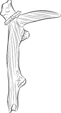
When it was first dug, the ditch at Avebury was 36ft (11 metres) deep and a probable 69ft (21 metres) wide, though, as with other henges, it was never meant to be a defensive structure since the ditch lies within the banks, which would make it hopeless for defensive purposes. It can only be described as ‘ritual’ in intention and it was a feat of engineering that beggars belief, especially since it was dug out of natural chalk using nothing more than deer antlers for picks.
The spoil was most probably removed from the site in baskets of the sort we know to have been used in the construction of the nearby Silbury Hill, and I suppose it isn’t out of the question that much of the material removed from the huge ditches of Avebury is presently to be found incorporated into Silbury Hill. It would have made great sense to use this material, rather than spreading it across the landscape. Even the contemplation of removing all this earth and chalk is so daunting it is hard to imagine how anyone in that remote period could have planned such a task, let alone carried it out. However, this presupposes that the builders of Avebury were somehow inferior to us in terms of brain power, which they most certainly were not. Their technological achievements may not have been so great as ours are but the evidence shows they could and did get things done.
Figure 31: A red deer antler of the type used to dig the extensive ditches around Avebury
Such a monumental amount of chalk and earth had to be shifted to make the henge at Avebury that it must have taken years, if not generations, to complete. It is staggering that such a plan was brought to fruition and that the place was then peopled by huge stones, one of which weighs an estimated 100 tonnes.
The stones at Avebury are all relatively local and few, if any of them, were substantially altered before they were dragged into place and erected. Rather, it seems that the planners chose the stones very carefully for grace and form, and probably to achieve objectives we can now only guess at.
Avebury stands on a slight chalk ridge, a little higher than the surrounding countryside and it is part of a significant ritual landscape that may tie it in with Stonehenge, and which certainly associates it with nearby Silbury Hill and West Kennet Long Barrow. Some disturbance of the land prior to the building of the monument (as early as 3300 BC ) shows post holes to have existed, indicating that either there was a timber ritual site already in place or that people had been surveying the site for its astronomical possibilities for some time. In the case of Avebury, both the henge and the stones were completed at more or less the same period and certainly within a few hundred years of each other.
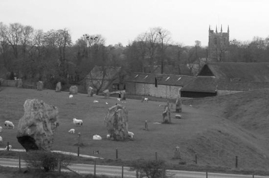
Figure 32: Avebury ring now encompasses part of the village of Avebury within its massive area
The Circles
Within the henge the remnants of the once 99 massive sentinels that stood around its periphery are a reminder of the physical effort that went into building Avebury. And as if it wasn’t enough to create such a massive henge and outer circle, the builders then went on to create two separate stone circles within it. These were both roughly the same size, the southernmost one having a diameter of 118 yards (108 metres) and its northernmost partner being 107 yards (98 metres) in diameter. (Actually, some experts think that the smaller circles came first.) Both of these inner circles have suffered from the ravages of time. This is partly because within the henge of Avebury lies the village that bears the same name. Not only was stone taken for use in building but after the 14th century the Church decided that such structures must be the work of the Devil and therefore the stones should be toppled, buried, or if possible destroyed altogether. As a result the inner circles contain few stones now and the village has ensured that the southern one is all but gone.
The West Kennet Avenue
Also associated with Avebury is an avenue of stones, the West Kennet Avenue, that begins at the southern entrance of Avebury. It was 27 yards (25 metres) wide, flanked by standing stones, and it was originally 1.6 miles (2.5km) in length. The West Kennet Avenue ran from Avebury to another structure known as the Sanctuary. Probably 100 pairs of standing stones flanked the Avenue, which, according to the most recent dating of finds associated with it, was completed around 2200 BC . The Sanctuary is a rather puzzling site. It once contained six rings of timbers and may have been a large building with a turf roof. Its association with Avebury via the Avenue shows it to have been part of the same ritual landscape, and no doubt processions of one sort or another took place between the two sites. There are signs of domestic habitation at the Sanctuary because animal bones and pottery have been found there, which is rarely the case inside henges. The Sanctuary was altered around 2100 BC , when two stone circles were created at the site. Alas for the visitor, the stones at the Sanctuary were destroyed or used elsewhere in 1723, though concrete markers show where many of the stones originally stood. In any case, the site was never of the same scale as that of Avebury.
Extending from the western entrance of Avebury is what remains of another avenue, this one known as the Beckhampton Avenue. This once led to the Longstones of Beckhampton and, before its stones were broken up and removed, it would have looked very much like the West Kennet Avenue. It has been conjectured that the two avenues together would have had the appearance of a giant snake, with its head at West Kennet, its tail at Longstones, and with Avebury in the centre of its sinuous body. I remain open-minded about this but since any winding path on the landscape could be said to resemble a snake, not many experts are all that enthusiastic about the possibility.
Avebury’s Revenge
Such destruction fell upon this magnificent site in the 18th century that it is almost poetic justice that the crushed body of a man was found under one of the fallen stones in the 1930s. This giant of a rock is now called the Barber Stone because the unfortunate individual found beneath it was carrying on his person a lancet and a pair of scissors, the tools of a barber surgeon of the 18th century. It seems that, no doubt together with other villagers, he was trying to topple the stone when it fell on him. Whether out of superstition or simply because the stone was too large to move, his body was left where it lay. This is not the only instance of a megalith that ‘fought back’ because similar discoveries have been made in Scotland.
In the A–Z section of the book, under Sexual Stones and elsewhere, I mentioned the theory that alternate tall stones and squat, diamond- or lozenge-shaped stones in circles, are often said to represent the male and female genders. Whether or not this is the case, such an arrangement is definitely to be seen at Avebury. With the exception of some of the giant standing stones, such as Rudston and the Devil’s Arrows, the sheer bulk of the stones lining the henge at Avebury makes them amongst the largest ever to be hauled about and erected during the Megalithic period.
Both Avebury and Stonehenge are linked together as a World Heritage Site and although this is gratifying, because it means they will be looked after well into the future, it is something of a pity that other, even more extensive, sites elsewhere in the British Isles do not get the same treatment. Avebury is supervised by the National Trust but since the henge lies within an established and living community it has been impossible for the authorities to rope off the site, in order to either charge people to visit or make sure nobody touches the stones. This means you can go there at any time. However, to compensate, there is a museum and gallery, together with a shop and the restaurant at which the National Trust will be more than happy to divest you of your hard-earned cash.
Early Visitors
I am willing to bet that if you have not been to Avebury before you will be singularly impressed by its scale and its timeless atmosphere. Through the eye of the imagination it is possible to see the site as it must have once looked, with its sinuous avenues leading off into the distance and with the bulk of Silbury Hill close by. In its own way this may once have been as important as Canterbury Cathedral would one day become and it is likely that people from all over our islands came to view it during its finest phase. People travelled about much more in prehistoric times than we have often given them credit for, and with DNA evidence now giving us so many answers, we are starting to realize that a good percentage of the population moved about the landscape readily. Avebury could have been a place of pilgrimage and it would certainly have been impressive – even before the National Trust came along to make sure it keeps astounding people well into the future.
No photograph or drawing can offer a true impression of just how large some of the stones at Avebury actually are. It is only when one stands close to some of them that the real effort involved in moving them into place becomes obvious. Even with a great deal of manpower the effort seems staggering. For example, countless ropes would have been needed and all of these would have had to be made by hand, probably across many months or years. The scale of the job is breathtaking.
We have no comprehension of the sort of ceremonies that may have taken place at Avebury, though it stands to reason that such a massive effort to create such a site means it must have been of the greatest importance to people in the vicinity, and probably from across Britain as a whole.
It used to be thought that our Stone Age ancestors were brutish, ignorant savages, with little intelligence. Anyone who spends even a short time within the stones of Avebury will quickly realize that it took real intelligence and perseverance to create such a massive structure. The level of organization necessary was quite definitely equal to that involved in major civic undertakings today.
Silbury Hill, near Marlborough, Wiltshire
| LATITUDE : 51° 24’ 56.79” N | LONGITUDE : 1° 51’ 27.33” W |
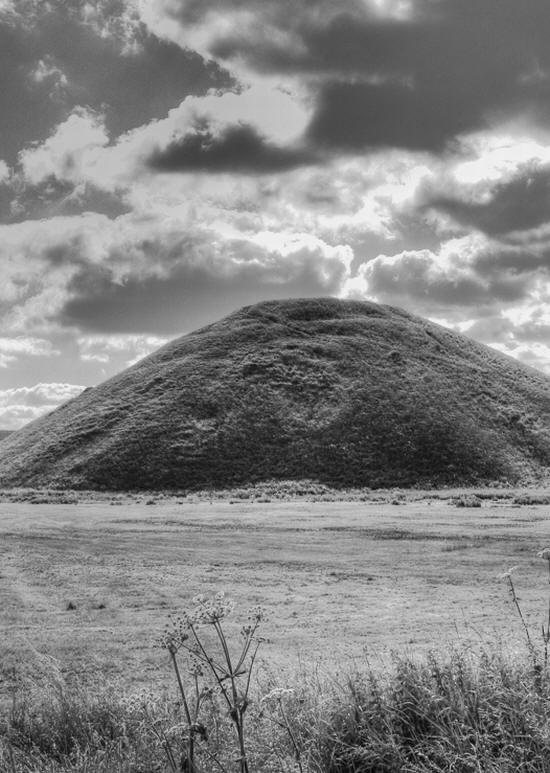
Close to Avebury and easily seen from the henge is the extraordinary bulk of Silbury Hill. In my estimation Silbury Hill doesn’t get the press it deserves. For starters it is the largest man-made hill in Europe and the only example on such a grandiose scale in the British Isles. It is deeply shrouded in mystery and probably represents one of the single most time-consuming projects ever to be completed in a relatively short place of time during prehistory anywhere in our islands.
As seen from the landscape today Silbury is a large, conical hill. It is 44 yards (40 metres) high and its base covers around 5 acres (2 hectares). These days the top of the mound is flat, though it is suggested by archaeologists that this was not always the case. It is estimated that the rounded top of the mound may have been flattened off comparatively recently, possibly for defensive purposes. Until quite recently the age of Silbury Hill lay within the realms of conjecture. However, in 2002 during remedial work, a red deer antler was found in situ. This had once been used as a pick to move the chalk necessary to create the hill. A reliable carbon dating showed that the second phase of the hill, during which the antler had been used, took place around 2500 BC .
More than a Pile of Earth
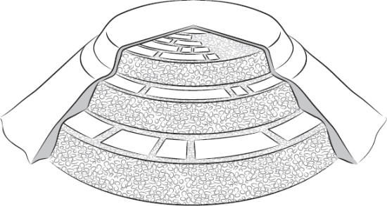
Silbury Hill is far from being a simple mound of earth. On the contrary, it was well planned, was built in two (or perhaps three) separate stages, and it may once have been surrounded by a very impressive water-filled ditch. When work started on the project, Silbury represented a small and fairly insignificant natural hill. For the first stage of the building a gravel core was created, within a kerb of stakes and large stones. Onto this were piled turfs, followed by basket after basket of loose chalk rubble and earth that had been dug from the surrounding area. Most of the early material came from a ditch that may have formed a water-filled moat, but this was later filled in again when it was decided to make the hill even higher.
Figure 33: Silbury Hill
At this time, not only all the material necessary to enlarge the hill was required, but also a significant amount to backfill the ditch. This leads us to an interesting point. It is estimated that, in total, the creation of Silbury Hill consumed 18 million man- (or woman-) hours of labour. Bearing in mind that the population of the British Isles at this period was extremely small, we have to find ways to justify the amount of effort necessary, for what were essentially subsistence farmers, to contemplate such an undertaking. Did the people concerned willingly give their spare time for months, years or more than a generation, or were they somehow coerced into the project? Of course there is no way of knowing, though ideas do change. It used to be thought that thousands of slaves had been used to build the pyramids of Egypt but we now know that this was not the case and that people from all over Egypt willingly co-operated in such projects at times of year when their farming allowed them to do so. To them it was a matter of religion and pride to participate in something so crucially important and it is probable that the same was true for the people of what is now southern England when Silbury Hill and the other local monuments were planned and constructed.
Modern Excavations
All sorts of tunnels have been driven into Silbury Hill across the last 200 years. Doubtless the earliest searchers were looking for what would surely be a magnificent tomb if the hill was merely a giant burial mound, though they didn’t understand that the burial practices at such a remote time were somewhat different. In any case, no such interment has ever been found. It seems that the hill is exactly what it appears to be – a very carefully constructed mound of stone and earth, the function of which was not funerary but rather ceremonial in some way. So cleverly did these prehistoric engineers plan the final hill that it is estimated that the centre of the top of the mound is less than 3ft (1 metre) away from the centre of the original foundation at the bottom. The mound was originally built in steps – it only weathered into its conical shape over a vast period of time. Even more significant is the fact that, because it was made primarily from chalk, it would have glistened in the Sun when it was first built and would have been seen from many miles away.
Evidence of purpose for structures from such a remote period often relies on frequency. There are, for example, very many long barrows and round barrows (albeit from a different period to the creation of Silbury Hill). Because so many have been excavated and so much material has come to light, it has been possible for us to reach some fairly definite conclusions about how the barrows were made, and even more importantly – why. In the case of Silbury Hill we have only this one example. Silbury is absolutely unique – a tour de force of prehistoric effort for which there is no apparent explanation that would make sense to us. In a worldwide sense it is far less unique. Building earth pyramids and artificial hills has been popular for our species across much of the planet’s surface and since time out of mind. If something such as Silbury Hill had been found in Central America, North America, in Asia or a host of other locations, it would hardly have raised an eyebrow. There are, after all, artificial mounds in various parts of the world that make Silbury Hill look like a pimple in comparison. But for us, here in the British Isles, it is a one-off and certainly not part of any evolutionary tendency that can be seen elsewhere.
Figure 34: Silbury Hill is thought to have been originally built as a spiral of flat banks
Making a Mountain
This makes Silbury Hill all the more compelling. Of course in islands such as ours we are used to seeing hills, and archaeologists are also used to finding that our ancient ancestors were drawn to natural mounds, unusual hills and mountains, for a host of different reasons. What we are not used to is when, in a place replete with natural mounds, people should take the decision to create one of their own from scratch. Silbury remains an enigma. It is a curiosity and a substantial work of art – as well as a gift to us from our remote ancestors. It might be best in future to stop trying to destroy it by tunnelling through its bulk but rather to enjoy it and to scratch our heads in wonder.
Just as it was possible for me to walk amongst the uprights and touch the stones at Stonehenge when I was a child, I also had the privilege of climbing Silbury Hill – a joy you will not be allowed to experience these days. Maybe that is as it should be but it seems a pity all the same. The view from the top is spectacular and may have been part of the reason Silbury Hill was built in the first place.
Castlerigg, near Keswick, Cumbria
| LATITUDE : 54° 36’ 11.78” N | LONGITUDE : 3° 5’ 46.08” W |
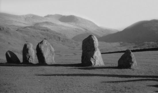
Set high within a landscape of towering hills and a location that is heart-achingly beautiful at any time of year, Castlerigg is probably my personal favourite amongst the English stone circles. It is located in Cumbria, within the area of England known as the Lake District and is not too far from Keswick (where you can get an excellent lunch or tea).
It is a mark of respect to the remoteness of this particular circle that it has remained so intact across such a vast period of time. Local superstition, together with a preponderance of building stone all around these rocky slopes, mean that Castlerigg has been left more or less totally unmolested – except by the weather, which can be ferocious in these parts.
A Flattened Circle
Presently there are 38 stones to be seen, all unworked and local, and of varying sizes; though originally there were probably nearer to 41 stones comprising the circle. Actually, the term ‘circle’ is not absolutely appropriate in this case because Castlerigg is one of those mystifying circles that has a flattened side. Some people think this reflects the inability of its planners to create a true circle, but for my money this is a preposterous suggestion. The people who say such things have clearly not created a large circle for themselves, which by way of a number of different techniques is really quite simple. People who, as Alexander Thom shows, were capable of dabbling in Euclidian geometry would have had no trouble at all creating the most perfect of circles, which they did quite regularly in other places.
A more likely explanation is that the planners of Castlerigg, and other flattened or egg-shaped rings, went to great trouble to make certain that the finished result was not a true circle. Why would they have done this? One possible answer is that they were trying to ‘square’ the circle. These early engineers and mathematicians must have been very aware that the perimeter of a circle is ‘three and a bit’ times the length of its diameter. Perhaps this annoyed them to such an extent that they decided to create some of their circles in such a way that the perimeter was a true ‘3’ times the diameter. This is certainly close to being the case at Castlerigg, though of course in the absence of a true circle, definite knowledge of the diameter is a complicated thing!
Figure 35: Castlerigg in Cumbria – undoubtedly one of the most beautiful of all Britain’s standing stone circles
Christopher Knight and I have shown just how interested prehistoric site planners were in the relationship between the diameter and circumference of circles. From the very early henge builders onwards they appear to have been aware that although a true circle cannot be squared, it can be made to apparently fall in line with logic. For example, any circle that has a diameter of 233 units must have a circumference of almost exactly 732 of the same units. (Actually it’s 731.99.) This might not appear to be all that obvious or significant but they used this rule of thumb time and again. For example, it is reflected in the henge that underpins Stonehenge and in all the super-henges of North Yorkshire.
However the engineers that planned and built Castlerigg decided to deal with the incongruity of pi, they definitely did choose one of the most spectacular sites possible on which to place their circle, which as far as anyone can tell was completed around 3200 BC , though dating has been difficult due to a lack of datable artefacts from the site.
Like many of its Scottish counterparts, Castlerigg is quite remote. Doubtless the early farmers lived in the locality and it would have been them, or perhaps a peripatetic priesthood, that decided to gather the stones for the ring and place them in this most picturesque of settings. It’s so wonderful at Castlerigg, especially on a fine day, that the casual visitor might assume the circle was placed here simply so that those utilizing it, in whatever way they did, could also appreciate the ever changing view. In fact this is almost certainly not the case and it is much more likely that the landscape played a part in the site chosen for Castlerigg for reasons that had nothing to do with natural charm.
When one stands at the centre of Castlerigg it can be seen that the landscape all around, and especially the horizon, is replete with natural markers that are bound to remain the same throughout hundreds or thousands of years. These can be clefts in hills, hill summits, natural crags or a host of other features that may have been ‘incorporated’ into the working matrix of the circle.
Using Foresight
Alexander Thom suggested, and it seems to be eminently reasonable to think he is correct, that if one wishes to track stars, planets, the Sun or Moon along the horizon, a whole series of foresights and backsights will be necessary (see Foresights and Backsights in A–Z section). The backsight can either be placed in the landscape artificially, or it might be possible to use what nature has already provided on the horizon as an ‘aide-memoir’ for continued observation. If, for example, when seen from the centre of the circle the Sun at the winter solstice always rises through a particular cleft in a hill, one can always know that when the Sun does rise through that cleft as seen from the same spot, it must be the time of the winter solstice. In other words it is a way to understand the true length of the year and to plan sowing times and other farm tasks accordingly.
This is a relatively simple example. We now know that our ancient ancestors were tracking the Sun and Moon, as well as gaining a knowledge of planetary movement, and that they could achieve a tremendous amount with naked-eye observation, just as long as the rules always remained the same. So, with stones for foresights and natural marks on the landscape for backsights, they could, after many generations of observation, gain a tremendously good knowledge of the workings of the sky and therefore establish much about the day and year. All of this may have been studied in a religious or ritual context but the result would have been the same – knowledge.
This, I am certain, was part of the reason for building circles such as Castlerigg where we find them today. We are also dealing with a period during which light pollution was as good as nonexistent, and even now the sky when seen from Castlerigg is stunning, with the stars seeming to be so close it appears to be perfectly possible to reach out and grab some.
The Cove
Like many stone circles in the British Isles, Castlerigg has not been extensively excavated. Even if it was there is little likelihood that we would learn a great deal more. Just inside the circle, at the eastern end, there is a group of 10 stones forming a rectangle known as the ‘cove’, the purpose of which is completely unknown. It is amazing just how little archaeology is found within stone circles, though this offers its own clues. People certainly did not live or apparently even eat inside the circles, which is a good indication that they were ‘special’ and ‘apart’ from everyday life. There is a slight exception in the case of Castlerigg in that quantities of charcoal were found buried within the circle.
As befits such a mysterious place, there are local legends associating Castlerigg with strange lights that are often seen in the locality. These have been fairly reliably reported for a hundred years or more and they may even be related to the local rock strata and general geology of such a rugged spot. Perhaps it isn’t entirely out of the question to suggest that these strange floating lights might have inspired the Megalithic people to put their calendar/observatory/temple/meeting place, in this lovely, remote spot.
Thornborough Henges, near Ripon, North Yorkshire
| LATITUDE : 54° 12’ 36.64” N | LONGITUDE : 1° 33’ 46.68” W |
Thornborough Henges is the only site mentioned in the Impressive Sites section of this book at which the visitor, rather than being encouraged to visit one of the most important places in the British Isles, will find that he or she is less than welcome and actually discouraged. Despite this, few people could argue that Thornborough Henges does not rank amongst the most important prehistoric structures in the world, let alone in our small islands.
The scale of the undertaking at Thornborough was immense, especially when we realize that these three massive henges were not alone on the landscape. There are at least three other super-henges in the immediate locality – all of which only exist now as parch marks in the fields and crops of North Yorkshire. Thornborough itself has fared better, but the whole site lies on private land with no recognized access for visitors and, what is worse, its environs are under constant threat from gravel extraction.
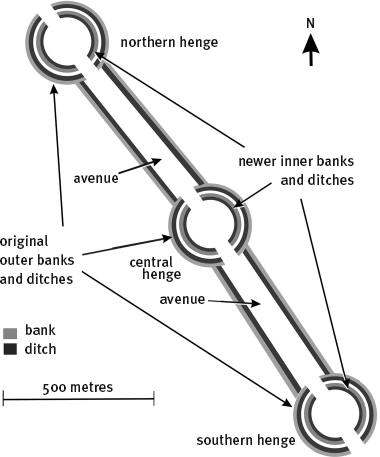
A Family of Henges
What remains are three super-henges, each around 263 yards (240 metres) in diameter and each in a slightly different state of preservation. The henges lie in a line, on a roughly northwest–southeast axis and the distance between the centre of the northernmost henge and that of the southernmost member of the group is just under 1 mile (1.49km). The area that includes these henges has been called ‘The Stonehenge of the North’ and English Heritage describes it as the most important ancient site between Stonehenge and the Orkney Islands of Scotland.
The best of the three henges in terms of access (though prospective visitors should be aware that the site is on private land) is the central henge. It still retains very impressive banks and some semblance of the massive ditch from which the banks were thrown up. These are known as Class IIA henges and so each has two entrances and exits, which follow the orientation of the group, being in the northwest and the southeast. In the case of the central henge it appears that there was originally an outer bank and ditch, which could have made the structure even larger. This was levelled early in the henge’s existence and the present structure created.
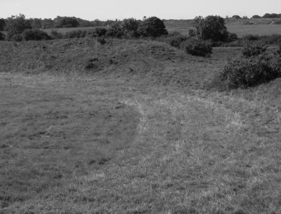
Figure 36: A bird’s-eye view of Thornborough Henges today
Figure 37: The probable original configuration of Thornborough Henges
Now comes the incredible part. Each of these henges, and all those that once accompanied them in and around the Vale of Mobray, were built around 3500 BC and just to get this into perspective, this date is a full 1,000 years before any of the pyramids in Egypt were constructed! Even more remarkable is the fact that the site of the central henge at Thornborough also contains a cursus (see Cursus) which was ‘overbuilt’ when the henge was constructed and which therefore has to be older than 3500 BC . This is a truly ancient site and was already around 500 years old before a deer antler was swung at Stonehenge. On these grounds alone the fact that it remains in obscurity and teeters on the brink of possible destruction is beyond belief.
Figure 38: Part of the remaining bank of Thornborough central henge
The Purpose of the Super-Henges
There are many theories as to why such huge henges were built and what they might represent. It has been the tendency of many experts to see them as important meeting places, where a generally small and dispersed population could get together or where trading could take place. Though a reasonable suggestion, it becomes slightly ludicrous in the context of the size of each of the Thornborough henges. At the time they were constructed it would have been possible to fit every man, woman and child in the entire British Isles into any one of these structures – so if they really served the purpose of a meeting place, why would three such large henges be needed? (As I pointed out, there are at least three such additional super-henges in the immediate vicinity apart from the Thornborough group.)
The other, and to my way of thinking far more likely explanation, is that the henges had a religious, ceremonial or practical purpose. But whatever the reason for their planning and construction, the amount of work necessary to create them must have been mind-blowing. Whilst Thornborough Henges has no stone circle, it should be remembered that the physical effort of digging a ditch and creating a bank on the scale we see at Avebury, and especially at Thornborough, is far more time-consuming than moving a few stones around the landscape, no matter how large they might be. I am not a sufficiently competent mathematician to work out just how long the Thornborough project would have taken but in total it must surely have been just as great a time span as the creation of Silbury Hill, which is estimated to have taken 18 million man-hours (though in reality the task at Thornborough could have been twice or three times as great).
Gypsum Banks
When the banks at Thornborough had been thrown up, they were then covered with a mineral called gypsum. This would have made them shine brightly in the Sun and it has been argued that they could have been seen from a great distance. This is something of a misnomer because a henge bank, no matter how impressive, would not present a good target from a distance when viewed at the same level, and the ground around Thornborough is actually fairly flat. It seems more likely that making the henges so bright was actually for the benefit of the gods, rather than for visitors to the locality.
Orion’s Belt
It was suggested (surprisingly enough by an archaeologist) that the arrangement of the three henges at Thornborough made them look strikingly like the three stars of the constellation of Orion known as Orion’s Belt. This comment, together with research that Christopher Knight and I had been undertaking regarding these early structures on the British landscape, led to an intensive phase of study into Thornborough on our part. The results of our efforts can be read in full in our book Before the Pyramids but in brief we came to the conclusion that Thornborough was not simply an approximation of Orion’s Belt, it was an absolutely faithful copy of it. What is more, the dimensions of the Thornborough henges, both individually and in terms of their relationship to one another, fully vindicates everything Professor Alexander Thom (see Thom, Alexander) observed regarding the standard units of measurement used in the late Stone Age and Bronze Age British Isles. Finally, we were led to a realization that henges such as those at Thornborough had been built as extremely efficient naked-eye astronomical observatories, though they undoubtedly also had a religious significance because, as I have stated elsewhere, science and religion at this early date were one and the same thing.
Of the three henges at Thornborough the real treasure is the northernmost henge. It is covered by trees, which seems to have been the case for a very long time. Because of this it has survived in quite remarkable condition – in fact it is the best-preserved henge to be found anywhere. Walking through it is something akin to taking an excursion in the Amazon rainforest, but if one really wishes to get an impression of how high the banks of these early henges were and how deep the ditches were dug, the northern henge at Thornborough is a perfect example (though of course, once again, anyone who goes there should know in advance that the henges are on private land, and are rarely open to the public).
Safeguarding the Site
A dedicated group of people, known as the Friends of Thornborough Henges, have worked tirelessly over many years in order for the site to get the recognition it deserves and to be fully protected by law and open to visitors. The wider area has barrows, burials of other kinds and all sorts of features on the landscape that are not understood. Working out what has already been destroyed by gravel extraction is impossible, and it is probably just as well because it would make any history buff weep in the knowledge of what we have already lost.
As Thornborough Henges are absolutely not open to the public (except on the odd day now and again) there is no museum, gift shop or café, and nothing to tell you where you are or what you are looking at. You will find plenty of fences and padlocked gates to keep you out, together with a lingering sense of indignation left behind by all those visitors who avidly believe that nobody should be able to divorce us from our common past and heritage.
The land around Thornborough is rich with gravel. It is partly the presence of the gravel that has allowed the banks of the henges to remain in place for so long. The site is also massive and that means that the thought of levelling it later for farming may always have been so daunting that nobody bothered to do so.
The northernmost henge at Thornborough is heavily wooded and seems to have been so for a very long time. Although the tree roots do some damage to the banks, in the main they tend to have protected the site. As a result it is probably the most intact henge in Britain. It has probably been left this way for so long as cover for game birds.
Old Oswestry, Oswestry, Shropshire
| LATITUDE : 52° 52’ 17.22” N | LONGITUDE : 3° 2’ 51.06” W |
On the borders of Wales, and very close to the modern town of Oswestry in Shropshire, is the remarkable hill fort known as Old Oswestry. Before you think about going there take a look at it on Google Earth, which gives a tremendous view of this Iron Age project and which shows the scale of the undertaking in a single glance. There are many higher hill forts in England than this one, but Old Oswestry is unique in a number of ways and has a charm and a grandeur that makes it second to none. ‘Charm’ might not be quite the right word to use when one considers that hill forts of this sort were designed to keep people out and to act as a deterrent to any would-be attacker, and indeed they were very efficient at doing so. Even the might of the Roman legions sometimes had difficulty dealing with British Iron Age forts which were impressive feats of engineering and which must have taken a great deal of time and effort to create.
An Early Settlement
Old Oswestry was once little more than a scattered group of huts on top of a natural hill. Then, around the 6th century BC , a double ditch and bank were created around the top of the hill. Later, more ditches and banks were added, probably because the hill upon which the fort is located is not especially high and its sides are not particularly precipitous. As a result, better defences were necessary.
Considering that Old Oswestry is so close to a thriving modern town, it has survived in a quite remarkable state. This is often the case for earthworks that are not ultimately subjected to agriculture because nobody has anything much to gain from disturbing them.
Apart from being a very healthy walk and a good insight into Iron Age life, especially in terms of the fighting that took place between various tribes at the time, Old Oswestry has a past filled with fabulous legends, all of which add significant colour to the experience. In Welsh (and after all you can see Wales from the top of it) Old Oswestry is called Caer Ogyrfan. In some of the earliest Arthurian legends Ogyrfan was a giant and also the father of Guinevere, famed wife of King Arthur. There may be a tiny grain of truth to be teased out of this legend. It is thought that Old Oswestry was abandoned after the Roman conquest of Britain but that it was reoccupied a few hundred years later, around the time the Roman legions withdrew from Britain and when the Saxon hoards began to pour into the islands.
Legends of King Arthur
This is precisely the time when King Arthur, or some Celtic warlord who ultimately ‘became’ King Arthur in the legends, was active in this part of the British Isles. As the rampaging, invading Saxons gradually extended their hold upon what is now England, the Celtic British were forced west into what we now know as Wales. (Interestingly enough the word ‘Welsh’ is Anglo-Saxon and means ‘foreigner’.) Arthur, a tribal chief, ex-Roman officer or mercenary general hired by the Celts, fought the Saxons up and down the Welsh border and also up into the Lake District and possibly as far south as Cornwall, trying to keep at least the west of the British Isles in Celtic hands.
Old Oswestry would have made a likely base for such a warrior, or one of his cohorts, and Ogyrfan could easily have been one of them. If he was a really good fighter and maybe of above average stature, Ogyrfan could easily have gone down in history as a giant. It is also possible (if you will allow me to stretch credibility) that Ogyrfan had a daughter that Arthur (or whatever he was really called) chose to marry – hence the legend. It is amazing how often there is a grain of truth supporting any legend, no matter how old or farfetched it might seem to be.
Impressive Vistas
The views from the top of Old Oswestry are impressive, looking in one direction into Wales and in the other out across the beautiful county of Shropshire. If you do decide on a day out to Old Oswestry, make certain to look at a very strange set of depressions in the ground, just to the north and east of the main entrance (they are easy to see on the Google Earth image). These depressions are a great mystery and they don’t seem to be part of the original defensive structure of the Iron Age fort. It has been suggested that they may have been of later construction and that they could have been the area where Dark Age chieftains (and for all we know King Arthur) stabled their horses, though they could equally well have been food storage pits of some sort.
If you are fit and healthy, take a run up the path that leads to the top of the fort. Now imagine that you have to cross each ditch and bank, which would also have sported sharpened stakes at their summits. At the same time, you would have been bombarded with both missiles and insults from above, whilst representing a sitting target when in the bottom of the ditches. On the western side of the fort there are an impressive seven ditches and banks. All things considered, it might have been better to stay at home. Fortunately you won’t have to take a spear with you these days but if the weather is fine this is an excellent place for a picnic.
Figure 39: A bird’s-eye view of Old Oswestry
It is very unlikely that manpower at the time would have allowed the Iron Age builders of hill forts such as Old Oswestry to guard the entire area of banks and ditches on the site. Rather it is likely that the finished structure was meant to be so impressive that it would make any would-be attacker think twice about the veracity and power of anyone who could have conceived of or created such a structure.
Old Oswestry seems to have always been a place of strategic importance. It is close to the site of a major battle between the petty kings in early Anglo-Saxon Britain and in later times it came to mark the boundary between England and Wales. The view from the top is quite magnificent and the hill has been used as a place from which to view the Welsh Marches for many hundreds of years.
Rudston Standing Stone, near Bridlington, Yorkshire
| LATITUDE : 54° 5’ 35.57” N | LONGITUDE : 0° 19’ 20.89” W |
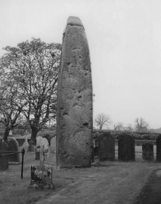
Rudston is a small village in the East Riding of Yorkshire, not far from the east coast seaside resort of Bridlington (where the fish and chips are amazing). The name Rudston is taken from Old English ‘rood stane’ which in this context means ‘stone of the cross’. That is because a little way out of the village, in the churchyard of the parish church to the east, is the tallest and most impressive standing stone (megalith) in the British Isles.
It is mighty to say the least. These days it is 25ft (7.6 metres) tall but it is thought that it was once a further 3ft (1 metre) taller. There is no stone of the sort from which the megalith is made to be found in the immediate vicinity and it probably came from around 10 miles (16km) away, at the coast near Cayton Bay. Since the stone is estimated to weigh in the region of 40 tonnes, getting it to its present site was no mean feat. There is another, much smaller stone of the same type in the churchyard, though this probably does not occupy its original site and could itself have been very much taller at one time.
Standing Stones and Churches
To find a standing stone in a churchyard or in close proximity to a church is not at all extraordinary. It was a deliberate policy of early Christians in Britain, and indeed everywhere else, to build their churches on sites where religious practice of one sort or another was already taking place. That way those visiting the sites were more likely to eventually become Christian. The church at Rudston today, All Saints, is Norman in foundation, though its dedication gives a clue that it may occupy the site of an earlier church. Many of the ‘All Saints’ churches of the north of England stand on Saxon, Celtic or sometimes even Roman foundations.
The site of Rudston is not famous in prehistoric circles simply for the standing stone. On the contrary, it seems to have been the centre of an important ceremonial landscape in prehistoric times. Not one but four cursus (see Cursus) pass through the locality and there are significant earthworks also close to the church. Some of the cursus are extremely long and were found to contain burials of beaker people. Since cursus tend to be amongst the very oldest of prehistoric structures they almost certainly predate the erection of the standing stone, which estimates put at around 1600 BC . I have no reason to argue against this except an instinct that it is probably considerably older, maybe in the range of 2500 to 2000 BC .
Figure 40: Rudston standing stone, the tallest standing stone in Britain
Dinosaur Footprints
Why this area should have been of such significance – and let’s face it, the place must have been important in order to convince locals to drag such a large stone so far – is not known but a possible clue is the discovery in the churchyard of dinosaur footprints. I have personally never seen these, though other commentators assure me that they are or were present. If they were very apparent in the Bronze Age it might have been assumed that some sort of dragon or an equally powerful creature had once occupied the place. It’s a tenuous clue but a possibility.
You can visit the standing stone at Rudston at more or less any time, though of course it is in a churchyard so a little decorum is appreciated. The stone appears to have cup and ring markings, though these are not especially distinct. Was there originally more than one stone here? The presence of the stump of a similar type of stone close by tends to indicate that this may well have been the case. I am unaware of any stone of a similar kind incorporated into the body of the church but I would not be in the least surprised if it was. However, for some reason this large specimen has survived. It now wears a slightly ridiculous metal ‘hat’, which seems somehow to emasculate it, but the sheer size of the stone makes a journey to Rudston a must (and of course there are those excellent fish and chips only a few miles away).
The Devil’s Arrows, near Boroughbridge, Yorkshire
| LATITUDE : 54° 5’ 33.49” N | LONGITUDE : 1° 24’ 7.62” W |
If you have ever travelled up the A1 in England, maybe going from the south up to Scotland, you would have passed close by the Devil’s Arrows, though without necessarily realizing that you did. The Devil’s Arrows are three massive standing stones, roughly aligned in a row and running nearly parallel with the line of the A1 as it passes close to Boroughbridge in North Yorkshire. It is thought that there could originally have been five or more stones forming the group and it is known for certain there were once at least four. The tallest of the stones is over 22ft (6 metres), making it second in height only to Rudston, though it is considerably broader in girth.
The companion stones are 22ft (6 metres) and 18ft (5 metres) respectively. Two of the Devil’s Arrows are in a farmer’s field and the other is by the pavement and adjacent to a house.
There is a rumour locally that the Devil’s Arrows once formed part of the periphery of a gigantic henge, which must have been over a mile in diameter. As far as I can tell there is no substantiation for this assertion. It is much more likely the stones date to around 2000 BC and formed the southern part of a ritual landscape that encompassed an area stretching well up beyond Thornborough (see Thornborough Henges). They could also have been erected to mark the southernmost passage of the Moon.
Millstone Grit
The stones are composed of Millstone Grit, a local common sandstone and it is not likely that they were worked much, if at all, before their erection on the site. They are now considerably weathered and fluted by the rain but this is a perfectly natural process for Millstone Grit that has been left unprotected for so many centuries. The stones probably came from around two miles away, at Plumpton Rocks, where such large rocks would have been readily available. All the same, it must have taken significant determination and effort to get the stones to the site and then erect them – especially if there were once many more than three. Further proof that this was indeed the case comes from the fact that pieces of exactly the same sort of stone have been found in the garden of a house adjacent to the site.
Figure 41: Two of the three Devil’s Arrows near Boroughbridge
The name Devil’s Arrows comes from a story that in remote times the Devil had taken offence at the old settlement of Aldborough, which is close by, and fired three enormous stone arrows at the settlement. Thanks to the general piety of the people thereabouts the Devil’s arrows fell short and landed where we see them today. Aside from colourful legends it certainly seems a pity that we cannot know for sure why so much effort was expended at a site that was probably extremely impressive in its day. The tallest of the stones extends 6ft (2 metres) into the ground. Its base was carefully sculpted and smoothed and packed around with stones to ensure it retained its position, which it has successfully done until today, at least 4,000 years later!
The Hurlers Stone Circles, Bodmin Moor, Cornwall
| LATITUDE : 50° 30’ 56.89” N | LONGITUDE : 4° 27’ 26.83” W |
Just a short walk from the village of Minions and close to Bodmin Moor in Cornwall is a very impressive site where not just one but three stone circles can be seen. These are arranged in a line, running roughly north-northeast to south-southwest. The central stone circle is slightly oval, indicating another attempt on the part of our ancient ancestors to square the circle. It is just over 44 yards (40 metres)‚ in diameter on average and retains 14 stones. These are by no means giants but the presence of three aligned circles of this sort is quite rare and must have made the site significant. The southern circle is smaller and now has only 9 stones remaining, whilst the northern circle has a diameter of about 38 yards (35 metres) and retains 15 of its original stones.
It looks as though significant effort went into getting the stones that were ultimately used to look right. They all reach to a similar height, even though they may extend to different depths, and significant finds of pieces of the same stone within the circle tends to offer evidence that they were hammered into shape with mauls prior to being erected. This seems to have been a common procedure because pieces of bluestone were found within the circle at Stonehenge. Perhaps the unused stone was considered of no value but it is equally likely that it was deliberately left within the circle as a mark of respect to its sacred nature.
The Hurlers probably date to that period around 2000 BC when so many of the standing stones of the British Isles were being erected. It is also likely that they had significant outlying stones to allow for astronomical sightings of one sort or another.
As far as the name is concerned, the term ‘hurlers’ meant something like dancers or musicians and it is said locally that there was once a group of such people taking part in revelries on the flanks of the moor, on, of all days, the Sabbath. The Good Lord took offence and turned the cavorting dancers to stone.
Arbor Low Henge and Stone Circle, Derbyshire
| LATITUDE : 53° 10’ 8.13” N | LONGITUDE : 1° 45’ 42.18” W |
Arbor Low, in the wonderful Peak District of Derbyshire, is a fine henge and stone circle but it has at its heart a mystery that has never been fully explained.
This is another spectacular site and it was probably chosen because it stands on a limestone plateau. I never cease to marvel at the capacity of our ancient henge-building ancestors for finding the most spectacular locations to erect their monuments but then, since they were no less intelligent than we are, perhaps their appreciation of natural beauty was just as great as ours can be.
Arbor Low is an oval rather than a circular henge, with two entrances, within which the stone circle was intended to stand. ‘Intended’ seems to be the appropriate word in this case because although at least 50 limestone sentinels wait patiently on the grass, and in a carefully arranged circle within the henge, all but one of them are recumbent. It is apparent that some of the stones have been broken, so there were probably originally less than 50 stones intended for the circle but there seems to be no doubt that when they were found or quarried, they were specifically chosen to stand upright.
For some time it was suggested that the same zealous Christians who tried to destroy other sites, and who in some cases succeeded, had toppled all the stones of Arbor Low, but this cannot be the case for one important reason. Search as they may, nobody has ever been able to find sockets that the stones once stood in, and no matter how much time elapsed since they were upright, these would not disappear altogether.
It is estimated that the stones were brought to the site around 2000 BC and the henge is almost certainly slightly older. Later in the Bronze Age some of the material from the bank was used to create a cairn burial close by. This was excavated in the 19th century and found to contain a cremation burial.
Recumbent Stones
There seems to be no satisfactory immediate answer to the puzzle of why a complete set of stones was manhandled to this site and then left, lying in the grass. Perhaps the builders were subjected to a natural calamity, such as plague or famine, and so decided that it was not the will of the gods that the stones should be erected. Is it possible that they were caught up in some sort of tribal struggle that left so many of them dead there were not enough able-bodied locals around to erect the stones? It seems likely that we will never know, but this site does seem to have a strange atmosphere – a sort of brooding stillness that I haven’t registered at other henges and circles. If you happen to be close by or fancy a little excursion into one of the most picturesque parts of England, Arbor Low is definitely worth a visit.
Derbyshire is part of the uplands of the North Midlands of England. Much of the land is moorland and some is extensively wooded. There are many pre- historic monuments of one sort or another to be found across the county and some which still await discovery. Scanning Google Earth is a good way to start looking, especially on rainy days or during winter.
South Cadbury Hill Fort, Sparkford, Somerset
| LATITUDE : 51° 1’ 27.79” N | LONGITUDE : 2° 31’ 49.71” W |
Down in the southwest of England is the county of Somerset, famed for its cider and the home of what must be one of the most charming English dialects to be found throughout our islands. There is no doubt that this area was well populated throughout prehistory though much of it, and especially the Somerset Levels, was flooded for large parts of the year. Glastonbury is in Somerset – a town steeped in history and a place well worth a visit, whilst nearby Glastonbury Tor, a natural hill that rises well above the low-lying ground around it, is also fascinating. It is said that the Tor, which until relatively modern times would have been an island amidst lakes and marshes, was the famed Avalon of Arthurian legend. In truth there are many ancient sites to see in Somerset but probably the best of them, and another with Arthurian connections, is the hill fort of South Cadbury.
South Cadbury must have risen out of the southern edge of the Somerset Levels in a very impressive way, back in the time when late Stone Age people chose to live there. It would have made a good base because it is quite high compared to the surrounding countryside (the summit is 500ft (152 metres) above sea level) and an ideal location to live for those engaged in wildfowling and hunting in the marshes.
Britain becomes Warlike
Archaeological finds indicate that the site was also occupied during the Bronze Age, though probably in a domestic rather than a defensive capacity. The date at which South Cadbury started to take on the look it has today seems to have been around 400 BC. This was a warring period in the British Isles and certainly seems to have been a time when almost everyone was rushing to build defensive structures of one sort or another. We know that the various tribes living throughout our islands did not always get along happily together. Proof of this comes from the way the invading Romans were able to use old enmities between certain of the Iron Age tribes of Britain for their own purposes. Had Britain been defended by a single people under an all-powerful king it is far less likely that the Romans could ever have successfully invaded or occupied the place.
Around 400 BC the locals in the district got together, presumably under their tribal king, and began to make the hill at South Cadbury into a fairly impregnable fortress. ‘Fairly’ is an appropriate word because there is archaeological evidence that great destruction took place here even before the Roman invasion and the legions managed to storm the place successfully soon after the conquest of AD 43.
The fort at South Cadbury involved the creation of four sets of banks and ditches, on a hill that was already fairly steep. These banks would have been defended by stockades and there may well have been sharpened stakes driven into the ditch bottoms and bank sides. The result was the best-known and probably one of the most impressive of the British hill forts of the Iron Age.
For Living or for Fighting?
There have been arguments about the extent to which hill forts were used as places of regular habitation. Back in the 1950s and 1960s I was taught at school that hill forts were usually empty and that only during times of threat was everyone, together with their livestock, herded into the hill forts and the gates firmly shut against an enemy. Archaeological digs at South Cadbury show that the picture is not quite so clear-cut. Evidence of constant occupation has been found within the banks and ditches, to the extent that a smithy existed there, together with a significant number of houses and even a structure that could well have been a temple. This seems reasonable enough because the amount of land within the hill fort is quite substantial.
What now seems much more likely is that some people did live within the hill forts on a more or less permanent basis. Perhaps they held the equivalent of markets, where people from the outlying communities could come to buy and sell their goods, and with a more cohesive tribal structure developing in the Iron Age, it is likely that chieftains or petty kings spent a considerable period of time in such strongholds. Iron Age culture in the British Isles was quite advanced, well before the Roman conquest. Some of the tribal areas were large and powerful – even minting their own coins and trading heavily with other tribes and also other countries.
South Cadbury has been a treasure house for archaeological discoveries. In the second half of the 1960s the site was extensively dug by Leslie Alcock and many of the finds that he and his team made can still be seen in the Somerset County Museum in Taunton.
The Arthurian Connection
King Arthur has little to do with a book about prehistoric sites but not to mention him in connection with South Cadbury would be a pity. If Arthur ever did exist, he is most likely to have been around in the 4th or 5th century AD , though stories associated with him are clearly much older and go back to the pre-conquest Iron Age. It is suggested, not just by folklorists, but also by some expert historians, that Arthur may have had one of his headquarters at South Cadbury. It is known that the site was reoccupied during the Dark Ages and so, in deference to a legend that is as good as an invitation to print money, the place is now often referred to as ‘Cadbury Camelot’.
For a really great day out it might be good to visit South Cadbury and then maybe to take in Glastonbury and the Tor, which are 12 miles (19.3km) to the northwest. Make sure you are wearing stout footwear, and especially so if the weather has been wet. It should also be borne in mind that whilst South Cadbury is lovingly maintained it isn’t always easy going and parts of the journey to the top are quite steep – though nowhere near as steep as Glastonbury Tor.
Belas Knap Chambered Long Barrow, near Cheltenham, Gloucestershire
| LATITUDE : 51° 55’ 35.83” N | LONGITUDE : 1° 58’ 4.81” W |
It is not all that common to find a good example of a chambered tomb in England. Though there are examples to be seen in this part of the British Isles, the best of the chambered tombs are in the Celtic heartland, in Wales but especially in Scotland and Ireland. It is for this reason that I have included Belas Knap in my list of interesting sites to visit. True, Belas Knap is a complete recreation – in other words it probably does not look exactly as it once did, but to my way of thinking it has been sympathetically restored and it does give a good impression of what the tomb must have looked like when it was first created.
Before you go racing off to the Cotswolds, which is where you will find Belas Knap, south of Winchcombe in Gloucestershire, do be aware that to get to the tomb you will have a very steep climb. The effort is definitely worthwhile though, because what greets you on arriving is a stunning example of a type of tomb known as a ‘Seven-Cotswold’ chambered long barrow, a type of structure confined to this region of England. There is a lay-by in the Humblebee Woods where you can park, and the steep path to the tomb is around the side of the woods.
Outside the entrance to the tomb is a typical courtyard, showing just how proud the builders of these tombs were of their handiwork. In the centre of this is a massive false entrance, which once again is typical of this form of tomb. The widest part of the barrow is this northern end and it then tapers off significantly towards the south. It is actually trapezoid in shape and is a good size, being around 77 yards (70 metres) in length. It was, and is, entirely covered in a carefully created mound – the long barrow.
The burial chambers, of which there are four, are located around the sides and the back of the mound. The false entrance was, as its name indicates, purely for show, or perhaps to discourage grave robbers (though this doesn’t seem all that likely because anyone who really wanted to get at the burials simply had to dig into the mound). We don’t know what the roofs of the chambers look like. It is entirely possible that they were corbelled, though they could have been covered with stone slabs. Some of them now have concrete roofs which, although not at all convincing, do at least offer an impression of what the chambers must have looked like when first created.
Elegant Walling
Extensive dry-stone walling was used at the site and it has been described as far from random in construction, since great care went into getting the courses right and creating a solid structure that would truly stand the test of time. To the west is one chamber, with another two on the eastern side of the mound. At the rear is a further cist-type chamber.
So much has been learned about the builders of these tombs and about the period during which they were active, that it is a wonder that Belas Knap is not much better known. The tomb was first excavated in the 1860s and it seems with greater care than usual. On hand were specialists in human anatomy, which led to some fairly startling conclusions about racial types living in and around the area when the barrow tomb was created.
A Cemetary
Upwards of 40 bodies were found in Belas Knap and one or two of them gave great pause for thought. This is because of a rule of thumb introduced by an interested professional who worked for Wiltshire county asylums in the 1860s. His name was John Thurnam. He had a good knowledge of anatomy and a fascination for ancient tombs. After extensive analysis of bodies found in all manner of burials from the Neolithic period and later, Thurnam came to the conclusion that long, narrow human skulls are usually found in long barrows, whilst those found in round barrows are generally less long and much rounder. In the main, Belas Knap lived up to his expectations in that most of the skulls found in the tomb were long. There was one exception because a round skull was present. It was an isolated example and it is now generally accepted that this belonged to a young man of a different race who was captured by those who built Belas Knap and probably sacrificed – or perhaps he was killed in battle. This is a puzzle that will probably never be solved but it is fascinating all the same. Curiously enough, the long, narrow skulls are usually associated with the Neolithic period, whilst the rounder skulls are commonly found to be of the Bronze Age – and may fall into the culture known as the beaker people. It seems self-evident that the two groups did coexist at some level, or the round skull could not have been associated with the other burials at Belas Knap.
Most of the bones found at Belas Knap were randomly placed, and had probably been de-fleshed at some other location, though one whole skeleton was found, which is apparently not unusual for tombs of this class – almost as if one really important individual was placed there in entirety for a very specific reason. Perhaps this was the person who supervised the creation of the tomb or maybe a local chief?
Although most of the bones were discovered long before carbon dating was possible, many were carefully retained and they have been dated since. They are all from roughly the same period, between 4000 and 3700 BC .
I can almost guarantee that nobody with an interest in things prehistoric will be disappointed with what they are able to view at Belas Knap. Incidentally, nobody really knows where the name came from. It could be ancient but it may equally be medieval in origin.
It should also be borne in mind that Belas Knap is situated in the Cotswolds, an area of great charm and many picturesque villages. And without wanting to make it sound as though I think of little else but my stomach, the various country cafés of the Cotswolds offer some of the best cream teas I’ve ever tasted.
Grimes Graves Flint Mine, near Thetford, Norfolk
| LATITUDE : 52° 28’ 31.43” N | LONGITUDE : 0° 40’ 32.44” E |
It cannot be doubted that the technical innovation that brought us from the rank of simple hominids to the place we hold in the world today was our use of tools of various sorts. High on the list of such aids to mastery of our environment were stone utensils and, in this part of the world for sure, flint. Everyone knows that prehistoric man used flint tools extensively and most people may also have learned that the quality and usefulness of flint tools changed and improved across a vast period of time.
What might not be so obvious is that flint cannot be found in every location across the British Isles. On the contrary, although an inferior type can be found in river beds or often on beaches, the best flint comes from the ground and then only in very specific areas. Since throughout the whole of the Neolithic period flint was an indispensable source of tools, for everything from hunting and chopping down trees to scraping animal skins, it stands to reason that all Neolithic people in the British Isles had to get hold of flint from somewhere. It is now generally accepted that flint was heavily traded across our islands, and from an extremely early date. This made its finding and transhipment one of the earliest professions, and way back in our history there seem to have been cultures that specialized in digging out flint, sometimes from significant depths and at great potential personal danger.
One such place is Grimes Graves, which is located on the border between Norfolk and Suffolk near the town of Brandon. At this site, between around 3000 BC and 1900 BC , many hundreds of tonnes of flint nodules were brought up from deep underground – so much in fact that it cannot simply have been intended for local consumption. The work at Grimes Graves was extensive, well organized, and obviously undertaken by men who were specialists – even if they were also local farmers.
There are a known 96 acres (39 hectares) of shafts at Grimes Graves and even allowing for the long period of time the site was in use, this is an incredible area. There are at least 433 known shafts, though many others could exist under more modern structures. This is partly because once they were fully exploited, each shaft was very carefully and comprehensively back-filled with the same earth that had originally been dug out of it – clearly to avoid the whole area collapsing because flint is found predominantly in chalk, which is not the hardest or most resilient of stones by a long way.
In order to get at the flint they wanted, the Neolithic miners dug through two other layers of less refined flint. They had to get down as deep as 40ft (14 metres) and it must have taken them a long time just to get to the required depth. Once they had done so they would come across the layer of superior flint they were looking for and then they would dig horizontal shafts, following the seam of flint as far as they realistically could, before backfilling the holes and starting again somewhere else.
Red Deer
The work must have been extremely cramped and was undertaken predominantly with red deer antler picks. It is possible that the farmers responsible for the mining kept herds of red deer because the antlers would not have lasted long and would have had to be replaced on a regular basis. The deer, when killed, could also have supplied leather for the bags they would have needed – and of course food at times when crops were scarce. The deer would not have had to be culled for the antlers because these are shed by the stags each year after rutting has taken place.
The reason the Neolithic and Bronze Age miners at Grimes Graves went to so much trouble and put themselves in undoubted danger to get at this particular layer of flint was that it was stronger, more resilient and, most importantly of all, easier to knap. Knapping of flint is striking pieces of it in very specific ways in order to achieve a good working edge. Visitors can actually climb down a ladder to experience a little of the conditions under which the miners toiled and for those who mix an interest in things prehistoric with a love of the natural world, Grimes Graves is also a site of special scientific interest and is the home of a great variety of plants and animal species.
Flag Fen Causeway and Reconstructed Bronze Age Village, near Peterborough, Cambridgeshire
| LATITUDE : 52° 34’ 25.23” N | LONGITUDE : 0° 11’ 31.74” W |
Flag Fen is near to Peterborough, England and it is the site where over 1,000,000 ancient timbers, which made up an ancient causeway, were found. These were arranged in five long rows and have been dated to a period between 1365 BC and 967 BC . Such a strange find is not common in the British Isles because climatically speaking it is rare for wood to survive the ravages of time. As a result, the discoveries at Flag Fen both surprised and delighted archaeologists. As its scale became more and more apparent, people began to wonder what the structures at Flag Fen had once been.
What made the whole situation even more mysterious was the great number of apparently ‘ritual’ finds that were associated with the site. The place had originally been a fen and experts already knew that watercourses and some bodies of standing water had, at certain times in our history, been considered ritually or religiously important. Broken swords or other votive offerings had been found in streams and rivers and it appeared that the same reverence had been shown to Flag Fen, but in this case on a much greater scale. Not only broken weapons were found but, for example, a number of polished white pebbles of a type of stone not readily available around Flag Fen or indeed anywhere near to it. Someone had brought the pebbles from a long way off and deliberately thrown or placed them in the fen, presumably as an offering to the gods.
A Flooded Landscape
As long ago as 1000 BC the level of the water in the fen was much lower than it is today, but over a long period of time it increased as the climate in the British Isles became wetter. This meant that year on year the many posts and other timbers at Flag Fen were gradually covered by water and by rotting vegetation, which preserved it and made many of the timbers found there as good as the day the water closed over them. The discovery of such well-preserved wood was a godsend to archaeologists because in such a situation it isn’t only carbon dating that offers a good knowledge of when a site was in use but the study of tree rings (dendrochronology). Tree rings are a reliable source of information about climatic conditions in the past, year on year. It is possible to match the ring sizes of a given tree to known and dated samples from elsewhere and in this way extremely accurate dating of any particular site can take place. In Flag Fen there were so many timbers that working out when any particular part of the site was built has been relatively easy.
Interestingly enough, not all the timbers used at Flag Fen were from trees one might have expected to grow in the area. Significant examples of oak have been found there, which must have been brought from a fair distance away. This has led experts to speculate that certain species of tree were considered especially sacred and that to bring them to the site and use them there may have added to the religious significance of the site or bring the favour of the gods.
The story of Flag Fen is told in the visitor centre there, together with an explanation of how the timbers are being preserved. After all, it was only their immersion in water that has saved them for so long. The moment they are exposed to air they begin to deteriorate rapidly. Techniques such as freeze drying have been tried, together with replacing the water in the sodden wood with silicone.
Also at Flag Fen there is part of a Bronze Age village on display, with roundhouses of the type our ancestors lived in. All in all, Flag Fen offers a great snapshot into our remote past, as well as raising more than a few questions about the religious preferences and general behaviour of the Bronze Age people of Britain.
Old Bewick Rock Carvings, near Alnwick, Northumberland
| LATITUDE : 55° 29’ 16.8” N | LONGITUDE : 1° 52’ 35.58” W |
In the wonderful county of Northumberland, in the very north of England, close to the village of Old Bewick, there is a wonderful collection of prehistoric rock carvings that give as good an example of cup and ring, and circular, markings as can be found anywhere in the British Isles. The carvings can be found in a field boundary 0.6 miles (1km) east of Old Bewick and many are carved into a large block of stone. It was at Old Bewick, in the 19th century, that people began to realize for the first time that the cup and ring markings commonly found across the British Isles were of genuine historical significance. Around Old Bewick there are a number of prehistoric structures, for example the Blawearie Cairn and Cist, as well as a double Iron Age fort, making this a landscape rich in prehistoric significance.
On the rocks at Old Bewick can be found extremely elaborate cup and ring markings, many joined together by deliberately carved grooves. In particular there are two cups with multiple rings, offering a figure-of-eight structure that is not commonly found, but of a sort that does exist elsewhere and which is very reminiscent of the carvings at Newgrange in Ireland.
Not far from the main rock there are others, which have also been heavily decorated, so do have a good wander around the locality. Maybe our ancestors chose these rocks because of their secluded position, or perhaps partly because they were already naturally weathered into cup marks that were easy to enhance. However, ‘easy’ is a relative word in association with these carvings. Many of the cup and ring markings were made before the advent of any sort of metal, so they could only be done in either relatively soft rock, or with a great deal of patience and over a protracted period of time. The crispness of some cup and ring markings is such that it is obvious that when first created they were well defined and deep, so clearly these were not idle graffiti but objects of reverence.
Professor Alexander Thom showed (see Thom, Alexander) that some of the cup and ring marks, and especially some spirals, were extremely carefully created, using geometry techniques that we normally associate with the ancient Greek period, which was considerably later.
Set in this wild and lonely place the many carvings near Old Bewick are a slightly unnerving sight. It is odd to think that we can connect in this spot with people who lived such an unbelievably long time ago and that they could have created something that would be almost as enduring as these old rocks themselves.
Despite decades of conjecture, it is fair to suggest that nobody has an answer for cup and ring markings. It used to be suggested that the ‘cups’ were designed to hold some sort of votive substance, such as milk, crude beer or maybe blood, but this explanation doesn’t make any sense because the cups are just as likely to be carved into vertical surfaces as horizontal ones. The truth is that we just don’t know. Perhaps the answer lies in astronomy, and our ancient ancestors were telling us something about the knowledge they had of the Sun and Moon. Most likely of all is the possibility that cup and ring markings had a peculiar religious significance and were considered as votive offerings to the deities in their own right. Or maybe you have a better explanation.
Lambourn Seven Barrows, Lambourn, Berkshire
| LATITUDE : 51° 32’ 33.41” N | LONGITUDE : 1° 31’ 37.12” W |
As I have intimated elsewhere in this book, many of our richest and most important prehistoric sites in the British Isles would not cause the average person to raise an eyebrow as they drove past in a car. Of course the impressive stones of Callanish or the vast bulk of Silbury Hill would cause a sharp intake of breath, but the vast majority of burial mounds of one sort or another, strewn across our landscapes, have become so weathered and now look so natural that one has to know specifically where they are in order to pay any real attention.
Such is not the case at Lambourn, in Berkshire, England. This site represents one of the most important and long-lasting landscapes of the dead to be found anywhere in Britain. It may not be as impressive as Newgrange, or as beautifully crafted as Meashowe, but in terms of scale it is still extremely impressive.
The area in question is known as Lambourn Seven Barrows, though why it should have gained this specific name is a mystery. There are at least 26 and maybe as many as 30 barrows in what must have represented a deeply revered ritual landscape, which endured for a very long period of time. The reason I mention it is not just because it is quite easy to see the barrows here, set out amidst the landscape, but that they represent a fair cross section of many of the types of barrows to be found within the British Isles. So, if you are the sort of person who wants to cross barrow types off on a list (a little like a trainspotter) at Lambourn you will be able to tick off bowl barrows, bell barrows, saucer barrows, disc barrows and even at least one long barrow.
A Wealth of Bodies
Just one of the barrows at Lambourn was found to contain parts of at least 100 different people, dating from a time long before individual burials were taking place in barrows. In these early days it seems likely that the dead were left in the open to decompose naturally before parts of their skeletons were interred on a communal platform that may eventually have been covered over to make the barrow. Different cultures over differing times built the barrows in their own peculiar ways – or maybe it was sometimes the same culture that was subject to its own form of ‘fashion’. There is great debate these days about how many invasions into Britain really did take place in prehistory. Of course there are clues, such as long skulls and round skulls, that could define different genetic types, but many of the invasions that used to be taught in school are now thought to have been immigrations and not to have represented violent interludes. Amongst unearthed finds in the barrows were a number of grave goods of high status, so perhaps places were reserved for the elite; these included a ceremonial battle axe and a mace head made of deer antler.
If you are driving through Berkshire, or if you really do want to see what a prehistoric barrow cemetery looks like, Lambourn Seven Barrows is as good a place as any. The nearby villages are very beautiful and you may see quite a few horses around because this is racing country, with many stables and studs.
Hambledon Hill Prehistoric Hill Fort, near Blandford Forum, Dorset
| LATITUDE : 50° 53’ 42.04” N | LONGITUDE : 2° 12’ 12.07” W |
Dorset is on the south coast of England, a lovely county and one that is especially wonderful in the spring and the autumn. There are many prehistoric sites in Dorset but the one that really stands out for me is Hambledon Hill. Although often designated as an Iron Age hill fort, which indeed it was, the site has an ancestry that goes back significantly longer. Hambledon Hill was dug first in the 1970s and was extensively examined. At this time it was discovered that the site had first been of significance as long ago as 2850 BC – a very long time before the Iron Age.
Actually this wasn’t really in doubt because within the confines of the later henge there are the remnants of two sizeable long barrows of a type that were not being created in the Iron Age. The area seems to have been some sort of causewayed camp because the top of the hill once had two separate causewayed enclosures. As to the use of the site in these early days it seems likely that this was originally a place of the dead. The bottoms of ditches are always useful places for archaeologists to find evidence because so much washes down into them across a long period of time. At Hambledon the ditches revealed a number of skulls, which may have been there as a warning to would-be invaders or which could have been associated with ancestor worship. Deer antlers were found – which is not remotely unusual since they represented the Stone Age and even Iron Age pick axe and would have been used to excavate the ditches.
The Remnants of Feasts
A significant haul of animal bones was also found by the archaeologists. These were of various types but it was established that most of the animals eaten on the site were slaughtered in late summer or early autumn. Some commentators have taken this as evidence that the site was occupied only at certain parts of the year, though this is far from clear-cut. On the contrary, even in relatively recent times the killing of animals in the autumn especially was quite common. With little in the way of available fodder it was not possible to keep any but the most important breed-stock animals healthy throughout the winter months, so the autumn was a good time for a feast.
If the site was only used at this time of the year there may be an indication that celebrations were taking place, which may have been associated with the long barrows and some form of ancestor worship that seems to have been endemic to the Neolithic and the Bronze Age.
Although the Bronze Age appears to have been relatively peaceful, at least in comparison with the later Iron Age when inter-tribe fighting seems to have been a regular event and fortified areas were common, there is an indication that the area might have been under attack at some stage. The skeleton of a young man was found and he had clearly been killed by an arrow wound. Associated with this find was a great deal of charcoal, which tended to indicate that the wooden ramparts had been burned as part of an attack on the enclosure.
Hambledon is clearly an Iron Age hill fort that gradually increased in size until it eventually reached the dimensions we see today. Parts of the hill are less protected because they are so steep but where the lie of the land dictated, there is a multiplicity of ditches and banks, making this one of the most impressive of the Iron Age hill forts to be seen in southern England.
Stanton Drew Stone Circle, Stanton Drew, Somerset
| LATITUDE : 51° 22’ 0.5” N | LONGITUDE : 2° 34’ 28.73” W |
The stones at Stanton Drew are not the largest to be found in the British Isles but the site is large and complex and certainly worth a second look. I have been there on numerous occasions and am always fascinated, trying to work out what the builders were attempting to achieve.
Set amidst what seems to have been a deeply revered landscape, there is more than one circle at Stanton Drew. The site is not far from Bath (one of the most beautiful cities in England) and it was of particular interest to those who created Bath in the 18th century. John Wood, chief architect of structures such as the King’s Circus, is said to have taken inspiration from both Stanton Drew and Stonehenge, and we have certainly found measurements in Bath that bear this theory out.
In addition to the three circles at Stanton Drew, one large and two much smaller, there are also two avenues lined with stones and a very strange arrangement of stones that is known as ‘the Cove’.
The smaller stone circles are not really circles at all because they are elliptical in shape. Once again we have to ask ourselves what our ancestors were trying to achieve with these elliptical, egg-shaped and flattened circles. These ellipses are around 102ft (31 metres) in diameter and 136ft (42 metres) in diameter respectively. The smaller one has eight stones, four of which are now recumbent, whilst the other small circle has 11 stones, though none of these are standing and may have been deliberately tipped over by devout Christians back in the 17th or 18th centuries.
A Significant Circle
As far as the larger circle is concerned (and this one really is a circle) it is a sizeable 370ft (113 metres) in diameter. This means it is the second-largest stone circle in Britain and is only dwarfed by Avebury. It has, in total, 27 stones, even if only two of them are presently standing as they once did. Sockets in the turf show that there were originally 30 stones in what is known as the ‘Great Circle’, which represents a splendid monument that must have taken some time to plan and erect.
The strange group of stones known as the Cove are to be found about 550ft (168 metres) west of the southeastern circle. They are close to a modern (well, relatively modern) public house which is intriguingly (but quite wrongly) named ‘The Druids Arms Inn’. The Cove comprises three stones. It has not been excavated in recent times and at present it offers no substantial clue as to what its purpose might have been. Together with the Great Circle the Cove creates a northeast–southwest alignment. To the north-northeast is a large standing stone, some 1,180ft (360 metres) away. It is likely that these outlying stones had some astronomical significance but the site would have to be accurately dated for this to become obvious and at the moment there is no absolutely reliable date for its construction.
It is likely that a timber structure once occupied this site, either at the time of the circles or perhaps before. A geophysical survey has shown concentric rings of post holes. The area is also surrounded by what must once have been a fairly impressive henge. The Great Circle and one of its smaller companions once had short avenues associated with them.
As is attested by the number of 18th-century ‘Druids’ that flocked to this site, and others around Britain when Druidism was very fancifully recreated, Stanton Drew has been a source of wonder for a very long period. In the main its stones, though knocked over, have not been smashed or buried.
As with other circles elsewhere, there is a local legend that the stones of Stanton Drew were once revellers. It is said that they sinned by dancing on a Sunday and for this most terrible of crimes they were summarily turned to stone.
Elegance and Complexity
This site is well worth a visit and it deserves more attention from those who study the prehistoric sky (astroarchaeologists) than it has enjoyed so far. It is very complex in design and without reliable dating it is difficult to know which sections of the site were developed first or what some of them might even have been for. Archaeologists are now less willing to excavate sites than they once were, believing that once a site has been disturbed, the secrets it contains will be lost for all time, whilst being willing to wait for technological innovation that might allow evidence to be collected without destroying what they would most wish to preserve.
Eighteenth-century antiquarians were as keen to look at Stanton Drew as they were at Stonehenge or Avebury. In particular, as I have mentioned, John Wood, one of the prime movers in the creation of the wonderful Georgian city of Bath, was virtually obsessed with Stanton Drew. Wood visited the site on many occasions where he took extensive measurements. His ideas regarding who built stone circles such as Stanton Drew, and the perceived truth today are far different but his meticulous approach to surveying both Stanton Drew and Stonehenge is a mark of respect from a man who was trying hard to get at the truth, even if he lacked the methods that are available to modern archaeologists.
It has been suggested, actually quite incorrectly, that the dimensions of Stanton Drew were used by John Wood in his wonderful circle of houses in Bath, which he named King’s Circus. In reality Wood used the dimensions of the henge at Stonehenge. But he did write a book on Stanton Drew and clearly considered it to have been of great historical significance.
Arthur’s Stone Chambered Cairn, Dorstone, near Hay-on-Wye, Herefordshire
| LATITUDE : 52° 4’ 53.66” N | LONGITUDE : 2° 59’ 43.28” W |
If any one of us had a five-pound note for each time the legendary King Arthur’s name was attached to prehistoric sites and structures up and down the British Isles, we would be quite wealthy. Yet another example is to be found at Dorstone in the county of Herefordshire, though it has nothing whatsoever to do with King Arthur. What you can see there today is the very impressive remnants of what was once a sizeable chambered cairn tomb. What makes this site so interesting is the sheer size and weight of the capstone, which stands on a number of surrounding stones and once formed the ceiling of the tomb. This capstone is shaped like a kite, is 19ft (6 metres) by 10ft (3 metres) and weighs an estimated 25 tonnes. True, it is not far up in the air as, for example, are the sarsen stones of Stonehenge, but it is still a colossal weight to be dragged to the site and then erected in its present position. How many willing or unwilling volunteers it took to place the capstone we will never know – nor can we do any more than guess at the technology they applied in order to get it into place.
False Entrance
It is thought that the cairn, which has now been dug away or weathered away, was probably oval and was in the region of 85ft (26 metres) in length; though not making this cairn a giant by any means, it was a fair size. One of the uprights in what was once the front of the tomb chamber carries cup and ring markings and it is thought that this stone probably formed part of the ‘false entrance’ which tombs of this sort in this area of England often possessed. Why these false entrances should have been present isn’t known but in front of them was usually a courtyard, presumably where ceremonies of one sort or another took place. In some ways this tomb is more like examples that are found in South Wales, so it may well be a member of the same group and therefore created by the same people.
Although the reader may not choose to spend too much time at this particular site, it is a great example of how people, who only a few years ago were referred to as ‘primitive’, set their minds on a particular course of action and saw a task through that would totally intimidate most of us today. They were, in their own way, skilled engineers and planners. Most of the techniques they used have been shown to be allied to woodworking, though on a much grander scale. This is not at all surprising. There is no evidence, except in extremely rare cases such as Skara Bray in Scotland, that the builders of the tombs and the stone circles lived in stone houses themselves. Rather they occupied roundhouses, created in the main from timber, wattle and daub. They were farmers, used to corralling domestic animals and skilled at erecting shelters for their livestock, as well as houses for themselves. We know from places like Flag Fen that they were experts at creating wooden causeways and they probably also built bridges. Stonework was not common, it was definitely the exception and in most cases it was clearly allied to something ‘above and beyond’ everyday life and experience.
If you do go to Arthur’s Stone, stand for a moment and take in the enormity of that capstone and ask yourself by what technique you could have brought it to this site and raised it onto its companion stones. Now imagine what the site must have looked like when it was covered in stones and earth. These are truly impressive structures and the realization of how sophisticated they were elevates our ancient grandmothers and grandfathers almost to the rank of giants, which is what our not-so-old ancestors thought they must have been.
Sutton Hoo, Melton, near Woodbridge, Norfolk
| LATITUDE : 52° 5’ 24” N | LONGITUDE : 1° 20’ 18” E |
I freely admit that I have cheated by placing Sutton Hoo amongst the locations included in the Impressive Sites section of this book. Since the title of the book includes the word ‘prehistoric’, I suppose no site should be included if it was created after recorded history began. This is certainly not the case with Sutton Hoo, which only dates to around the 6th or 7th century AD – which is well within recorded history. However, the site is still shrouded in mystery and in any case it was the place at which the most fabulous treasure ever to be uncovered on British soil was found. And it is for these reasons that I have decided to give Sutton Hoo a special, if slightly undeserved mention.
Post-Roman Britain
When the Roman legions finally left the shores of Britain, in AD 410, the locals were left to their own devices and their own defence. In an effort to keep out invaders they did not want, the petty kings of England often resorted to introducing mercenaries into their lands, to bolster their defences. In the south of England especially, many of the mercenaries came from Saxony, or from the region in the very north of what is now the Netherlands. These people became known as the Saxons and the Angles, and it is from the latter that the name of England is derived.
The plan might have been a good one, if only the mercenaries had done what they were paid to do and left it at that. Unfortunately for the petty kings of the British Isles, the Saxons and Angles loved it so much here they decided to stay, and what is more they invited a large number of their relatives and friends to join them. Eventually the incursions became so great that open warfare started to break out between what were now clearly invaders, and the indigenous population. Without the legions to protect them the Britons put up a sterling fight but it was a losing battle from the start. They were forced back into Wales, Cornwall and Scotland, whilst the bulk of what is now England eventually fell to the Saxons and Angles.
Right from the start that area of England known as East Anglia proved to be very popular with the Germanic immigrants. They established themselves in Norfolk and Suffolk, where Anglo-Saxon kingdoms developed.
Sailors and Warriors
The Anglo-Saxons were great sailors and great warriors. In addition, they stood at the point in history at which paganism, which had always existed here, began to meet Christianity, which arrived from the west and Ireland, and from the east and the Continent. It took a while, but eventually the Anglo-Saxon kings of England became Christian. In that period before full conversion took place, we find a definite ‘Dark Age’ during which very few records were kept. Later, monastic chroniclers would have a great deal to tell us about the Anglo-Saxon period, but prior to around AD 700, historians and archaeologists know little of what was taking place in England.
What we do now know is that at least some of the early Anglo-Saxon kings, especially in the east and south of England, grew extremely powerful and prosperous. We also know much about the sort of objects with which they liked to surround themselves, as well as understanding from just how far away some of these objects came. We have become aware of some of the Anglo- Saxon burial practices and of the local craftsmanship, especially in precious metals, which was clearly far in advance of anything that used to be considered possible for this era.
We know all of this because of what was discovered near Woodbridge in Norfolk in 1939. It was known that a number of burial mounds existed in the area – in fact some of them had already been dug and looted. A few finds remained but in the main there was little except scars in the landscape to show what had once been there. Sutton Hoo overlooks a tidal estuary and is about 7 miles (11km) from the coast. The land there is mostly sand and it seems to have been of special significance for burials for a very long time. Some 20 mounds were known to exist and the ones that had not been disturbed were of special interest to Edith May Pretty, who owned Sutton Hoo House and the land upon which the mounds were located. By 1937 Mrs Pretty, who had been listening to local legends that ‘untold gold’ was buried beneath the mounds, enlisted the support of Ipswich Museum, in the form of Basil Brown, a talented amateur archaeologist. Brown began working on one particular site, known as Mound 1. It had clearly been at least partly excavated but Mrs Pretty was adamant it should be looked at in more detail. Basil Brown set to, with very little help, and patiently began removing the earth.
An Undisturbed Treasure House
When the burial chamber in the mound was reached, it became clear that it lay undisturbed. At this point the British Museum became involved because what Basil Brown had begun to uncover was the greatest ship burial ever to be discovered from the Saxon period.
Unfortunately the discovery came at exactly the same time as Britain was facing war with Germany. All the objects were removed, in great secrecy, from the site, and were shipped off to London, but were brought back again for a treasure trove inquest, which decided the treasure rightfully belonged to Mrs Pretty. With true generosity Mrs Pretty gave the whole Sutton Hoo treasure to the nation and it now resides, in splendour, in the British Museum.
The Sutton Hoo treasure is simply stunning, and breathtaking in its scope and amount. In addition to a fabulous war helmet there is a fine collection of silver plate, some of which had come from Byzantium. Many of the items were clearly favourites of the buried king, such as parts of a harp and personal adornments of the finest enamel-worked gold. There were shield fittings, silver bowls, spoons, swords, horse harnesses and the most fabulous solid gold belt buckle imaginable. And all of this is just a part of the Sutton Hoo treasure, which showed itself to have belonged to someone of immense wealth and power.
A Powerful King
It is now generally accepted that the burial was that of the Anglo-Saxon King Raedwald, King of the East Angles, who reigned between AD 599 and 624 approximately. Raedwald himself seems to have been a pagan, but his daughter married Edwin, the first Christian Anglo-Saxon ruler of Northumbria and so the ship burial came at that all-important pivotal point in the Dark Ages, just before written records were kept.
Of Raedwald’s ship – a genuine ocean-going vessel, in which he had been laid to rest, little remained except the amazing pattern it had left in the earth. Nor were there any real remains of the king himself. But the treasure buried with him represents arguably the most important historical discovery ever made on English soil, not simply because of the artefacts themselves, but more because of the light they throw on such a dimly lit period of our history.
The site at Sutton Hoo is now administered by the National Trust. It is possible to walk around the entire site of the discovery and to learn a great deal about the burial itself and the story of its unearthing just prior to the Second World War. There is nearly always something significant taking place and Sutton Hoo is a great place to take the family. An award-winning exhibition is in place for interested visitors and there you can also see a full-sized replica of the burial chamber, together with facsimiles of many of the items that were discovered.
But if you want to see the real Sutton Hoo treasure, which I am pleased to say I have done on numerous occasions, you will need to visit the British Museum. There, you can stand in front of the glass cases and stare in open-mouthed wonder at some of the most beautiful works of art that our Anglo-Saxon ancestors were capable of producing. In the gleam of all that gold you, like me, might be left wondering whether the Dark Ages were really all that dark after all.