![]() New York
New York ![]() Ontario
Ontario
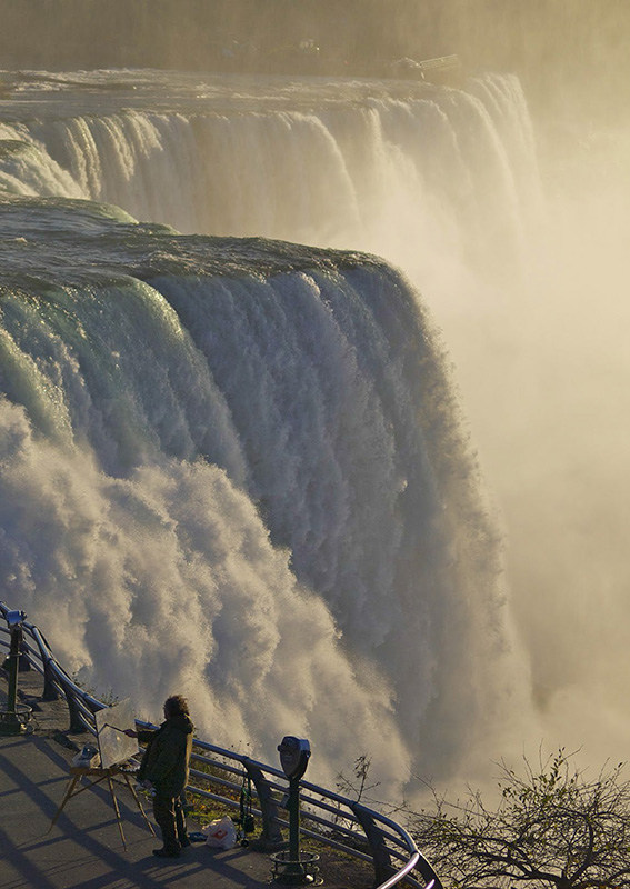
Plunging from a modest height of 167 feet, Niagara Falls is far from the highest waterfall in North America. But it is the most powerful—more than 4 million cubic feet of water a minute flow over the brink, enough to fill an Olympic-sized swimming pool every second. Niagara Falls is actually made up of three waterfalls: Horseshoe, American, and Bridal Veil, each separated by small islands. Horseshoe is the widest, at over 2500 feet, followed by American Falls (just over a thousand feet), and Bridal Veil (less than a hundred feet). The distance across all three falls is nearly three quarters of a mile.
From above, Niagara Falls is centered in the land bridge between Lakes Erie and Ontario, on the Niagara River just downstream from where the river reconverges after splitting around Grand Island. The United States–Canadian border actually runs through the west passage of the split river (the Chippawa Channel). At Niagara Falls, the international border is drawn somewhere under Horseshoe Falls; Horseshoe is on the Canadian side and American and Bridal Veil are on the U.S. side, although erosion blurs the exact line.
The Niagara River drains Lake Erie into Lake Ontario, and Niagara Falls, on the Niagara River, is a product of the last ice age. Around 14,000 years ago, at the end of the Wisconsin Glacial Episode (the last major glaciation in North America), the Great Lakes were just beginning to take shape as the ice sheets receded, leaving behind massive quantities of meltwater that filled up the basins we now know as the Great Lakes.
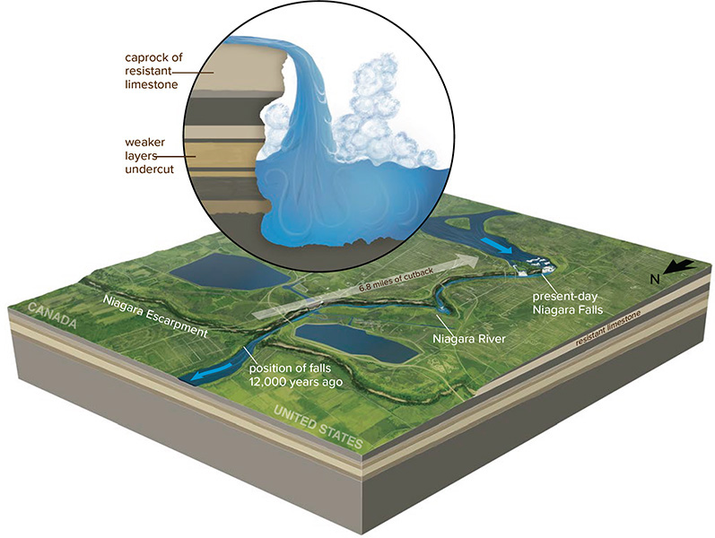
Turbulent waters plunging over Niagara Falls erode the rocks that make up the edge of the falls, causing the brink to move upstream at a rate of about a foot per year.
As freshwater from the lakes makes its way to the Atlantic Ocean, it plunges over the Niagara Escarpment, a caprock of dolomitic limestone running in an arc through the Great Lakes from Lake Michigan to Lake Ontario. This limestone was deposited in the Ordovician and Silurian Periods, starting around 480 million years ago, when much of the globe was dominated by tropical seas. Several waterfalls drop over the north-facing Niagara Escarpment along its 450-mile length, but Niagara Falls is the largest and most famous.
Niagara Falls used to be nearly seven miles closer to Lake Ontario. Over the past 12,000 years, it has retreated upstream to its current position as a result of water erosion.
From the air, it may be possible to see where Niagara Falls was originally located. It first formed nearly seven miles downstream from its current site, between present-day Queenstown, Ontario, and Lewiston, New York. Because of the falls’ tremendous erosive power, the brink has retreated upstream as the force of the cascading water erodes the rock of the escarpment. The shape of the falls has also changed dramatically, evolving from a small arch, to a horseshoe shape, to the large V seen today.
Erosion continues to define Niagara Falls, cutting the ledge back at a rate of a foot per year. The falls’ greenish hue is caused by very finely ground rock flour, produced at a rate of sixty tons per minute by the Niagara River. Over the next 50,000 years, the falls will continue to migrate upstream, eroding Grand Island, and whatever is left of a brink will eventually fall into Lake Erie.
Niagara Falls viewpoints take visitors right to the brink, offering a close-up view of this section of the Niagara Escarpment.

Niagara Falls may be visible en route to Rochester, New York, or Toronto, Ontario.