Once more the ruby-coloured portal open, Which to his speech did honey passage yield; Like a red morn, that ever yet betokened Wrack to the seaman, tempest to the field, Sorrow to shepherds, woe unto the birds, Gusts and foul flaws to herdmen and to herds.
And to mountaineers. When Shakespeare wrote the raunchy Venus and Adonis in 1592, he wove into it the common wisdom that a red sky in the morning portends bad weather, though in the evening it suggests the opposite. The disciple Matthew offered the same wisdom centuries earlier. Basic weather forecasting skills are handy for mountaineers as well as poets and prophets, even though meteorological terms and concepts may seem arcane at first. Weather profoundly affects the pleasure and safety of mountaineering in a number of ways throughout the year, and weather also strongly affects avalanche conditions in winter.
If you know anything at all about weather, it’s probably that weather systems track from west to east. You may also know that in the northern hemisphere winds circulate in a clockwise direction around high-pressure centers and counterclockwise around lows. And you may even know that local weather forecasts are more problematic near the West Coast, because much depends on exactly where storms originating in the Pacific or Gulf of Alaska actually make landfall; in the East, there are fewer mountains and more data history for accurate forecasts. You might already be in the habit of checking the weather forecast for the area where you expect to be climbing and change your objective or cancel plans altogether if things look bad. Hospitable weather is key to fast, bold climbing, and to comfort and success on every ascent. I have a partner who’s learned to read the National Weather Service forecast discussions, with their arcane terminology and computer models (discussions are where the NWS meat is found). He carefully picks days to climb and never gets stormed on the way the rest of us seem to.
Even with the official forecast (or official guess) under your belt, you may also know that high mountains and ranges are capable of making their own weather, because of the environment and the relief of the mountains themselves, and that conditions at various parts of a mountain system can be very different and change rapidly—whatever the forecast may say for lower elevations. To arrive at an accurate forecast, you need to factor in the effect of local conditions, based on your own observations. If you have an altimeter, you can note trends in atmospheric pressure, but your main data will come from observing clouds.
Gross weather forecasting is based on estimating the consequences of moving air masses, fronts, and pressure systems. Air masses are large volumes of air with horizontally uniform temperature and moisture; they assume the character of the ground below so they’re called polar, tropical, continental, marine, etc. Fronts are the margins where air masses meet and do battle. Pressure systems are regions of the atmosphere where the barometric pressure is definitively higher or lower than normal (normal is 29.93 inches or 760 mm of mercury; or 1,013.25 millibars, mb; or 1,013.25 hectopascals, hPa, or more correctly but less commonly, 101.325 kilopascals, kPa).
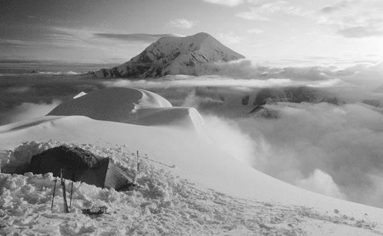
Clouds are the most evident indicator of weather. You probably already know that clouds on a summit, no matter how fluffy and innocent in appearance, usually indicate blustery conditions there. Lenticular clouds, so-called because of their lens-like shape, indicate high winds aloft. When near a summit they may not rule out pleasant conditions elsewhere, but when lenticulars, and especially multiple stacked lenticulars, form far down-wind of summits, windy conditions are likely to be widespread, and gusts on summits and ridges throughout the mountain range may be insufferably strong. Time to consider Plan B.
The fundamental concept behind an understanding of bad weather, or at least precipitation, is lifting. For significant precipitation to develop, air must be lifted (and there must be humidity and instability, too). Clouds form when warmer, moist air is lifted higher into the atmosphere; moist air is less dense than dry air, so it will rise even if it’s at the same temperature. Rising air expands, and expanding air cools; when the air cools to the temperature of the dew point (technically, to the lifting condensation level) invisible water vapor condenses on microscopic particles to form visible water droplets or ice crystals—clouds. If cloudy air continues to rise, it cools further, and water may fall out of the clouds as precipitation of many kinds. The reverse is true of descending air, which usually leads to pleasant conditions.
There are several ways that lifting significant enough to produce mountain storms can occur. Frontal lifting describes air forced upward by the displacement of one air mass by another. Convection or convective lifting occurs when solar heating at the earth’s surface causes warmed air to ascend into cooler air above, like hot-air balloons. The speed of the rising air may be 10 miles per hour. Convective lifting produces big cumulonimbus clouds that are associated with thunderstorms, such as those that seem to occur over the Rockies and Tetons almost every summer afternoon. In such clouds, convective lifting can exceed 50 miles per hour. Upslope lift is produced when air rises as it moves over gently rising land. The eastern sides of the Rockies are famous for big snowfalls during upslope conditions when a powerful winter low to the south brings Gulf moisture; upslope lifting is intensified by orographic lifting. The same effects may cause wet or snowy weather on the western slopes of any North American range. Orographic lifting describes air forced upward as it moves over a mountain range. It’s the most powerful lifting mechanism, ten times more powerful than frontal lifting, and accounts for the majority of precipitation in the western United States and Canada. Orographic lifting is the primary reason that mountain weather differs from flat-land or ocean weather and the forecasting thereof. Mountains and ranges affect local weather, and it’s the local weather that affects mountaineers.
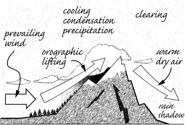
Orographic lifting.
Meteorologists use a plethora of Latin words to classify clouds according to their altitude and appearance. We can start more simply. High clouds are composed of ice crystals. These clouds, variously called cirrus, indicate moisture high aloft and warn of an approaching weather system in 24 to 36 hours. Middle clouds (6,500 to 20,000 feet), often forms of stratus clouds, may be composed of water droplets, resulting in well-defined edges, or ice crystals, resulting in wispy edges. Certain midlevel clouds indicate arriving weather systems that may be some hours away; other types, such as “fair weather cumulus” scattered in a blue sky, indicate high pressure and fair weather. Low clouds (having bases from ground to 6,500 feet) are the source of rain or snow because precipitation falling from higher clouds usually evaporates before it hits the ground. In mountains you may be well above 6,500 feet and in the thick of things as storms develop.
Some cloud types are of specific interest to mountaineers. Cumulus clouds look like clumps of white cotton, usually with grey, horizontal bases. They’re formed by convective lifting of moist air above solar heated ground; they almost never form when the ground is below freezing. Cumulus clouds may be formed or enhanced by orographic lifting in mountainous regions. Cumulonimbus clouds are heavy, dense cumulus clouds with massive vertical development produced by powerful convective lifting; their tops reach 20,000 feet or higher, where ice crystals and cirrus-like cloud components form. Their bases are usually dark and accompanied by virga (wisps of precipitation that don’t reach the ground), hail, or heavy showers that can dump a million pounds of water or more, showing just how powerful lifting effects can be and why, given the impermeable nature of mountainous terrain, climbers should avoid narrow drainages when even distant thunderstorms could produce flash flooding. Orographic clouds seldom form when the atmosphere is stable, but with a little instability orographic lifting leads to stratus clouds or to cumulus clouds if the air is even more unstable. Instability along with high moisture may lead to cumulonimbus clouds. Solar heating of mountain ridges causes nearby air to be warmer than air at the same elevation over valleys, increasing convective lifting that adds to orographic lifting and results in more cloud formation during the day that will abate in the evening when solar heating abates. Orographic lenticular and cap clouds indicate high winds (more than 40 miles per hour) even though they don’t appear to move; this is because they form as the wind moves up windward sides of mountains and dissipate as the air moves down lee sides—the air moves, but the cloud remains stationary. Banner clouds form off the lee side of sharp peaks when strong winds create a wake vortex there that pulls condensing air into it, making for great photos.
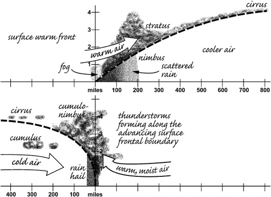
Warm front and cold front over flat land.

Basic weather map.
I might as well mention climate, the big picture of weather. There are four main factors that influence climate:
Latitude mainly influences the amount of solar radiation and relative proportions of day and night. This effect changes during the year because the earth’s rotational axis is tilted 23.5° degrees relative to the sun—the latitudes of the Tropics of Cancer and Capricorn.
Altitude affects air density, precipitation, wind, solar radiation, temperature (by about 3.6 F° per 1,000 feet), and atmospheric moisture. Every 1,000 feet (300 m) of rise in elevation is approximately equivalent, in terms of climate, to traveling 350 miles (560 km) farther north, at sea level.
Continentality means distance from the coast. The principal mountain ranges of the Americas run north-south, roughly perpendicular to the usual progress of weather systems. This isolates the climates of maritime, intermountain, and continental ranges and creates major differences in local weather and snowfall. Continentality has a significant effect on avalanche conditions. Usually, western slopes of North American mountain ranges are wetter because moisture is lost as eastward-moving air ascends as it passes over them.
Regional patterns of wind and ocean currents affect our weather. In summer the Bermuda-Azores High brings warm, moist air from the Gulf of Mexico into the United States and contributes to the development of thunderstorms in the Midwest. The Pacific High over the Gulf of Alaska causes weak northerly winds along the West Coast, bringing clear skies, low humidity, and warmer temperatures, save for local effects such as the spring marine layer fog along the California coast. The persistent California Low forms over Arizona, between these two highs, and the summer jet stream moves high over Canada. In winter, the Bermuda-Azores High continues to dominate weather in the eastern United States, but the Pacific High weakens and drifts south, exposing the West Coast to strong winds from the Aleutian Low that forms over the Bering Strait. These westerly winds bring extensive precipitation, as frontal systems drive maritime air into western mountain ranges. The storm track is typically north of California, through Washington and Oregon, and across Utah. The weak Great Basin High forms in the intermountain region, pouring colder winter air into the Great Basin as the mountains cool, especially at night. The jet stream in winter drops down from Canada to pass over the West Coast and California.
These descriptions are typical, but very general. Weather systems that are exceptions to these patterns are often given special names, like the “Pineapple Express” that comes out of the Pacific from the southwest to bring warm rain to northwest coastal mountains. Each mountain range has its own typical weather pattern. The Pacific High tends to block storms from the Gulf of Alaska during the California Sierra summer climbing season, but rare tropical storms from the west coast of Mexico can bring monsoon moisture into the Great Basin and Eastern Sierra. The precipitation that results is often widespread and copious, so Sierra climbers should watch for clouds moving in from the south, thickening clouds, and rising humidity. If rain occurs at night, a rarity in the summer Sierra, the arrival of a tropical storm system is confirmed; in combination with convective lifting, cumulous clouds can form that develop into powerful thunderstorms during the day. Learn from experienced mountaineers about the seasonal weather patterns typical for the areas where you intend to climb. You’ll find they are amazingly consistent (the weather patterns, that is, not the mountaineers).
Using local observations to forecast short-term weather changes means observing trends, and that means checking weather maps and forecasts, or discussions, for a few days before your climb and keeping an eye on local weather indications and your ear on your NOAA weather radio even as you hitchhike to the trailhead. A smattering of meteorological knowledge and your personal observations and experience make it possible to forecast short-term local weather with surprising accuracy. Just what a mountaineer needs. Mountain terrain affects wind, temperature, precipitation, and, to some degree, clouds, but not barometric pressure, so I’ll start there.
Barometric pressure is always corrected to sea level even though station pressure (actual pressure at the instrument) is measured, because altitude effects on air pressure would confound analysis. Falling barometric pressure (an altimeter indicating ascent even when you don’t move) indicates the arrival of a trough aloft or a cold front at the surface and therefore the possibility of an approaching storm. In far western mountains especially, the storm may be diverted elsewhere, or its frontal lifting may be increased by orographic lifting that would augment precipitation; in other words: things could go either way. If you’re referring to an altimeter, 40 to 60 feet of altitude gain over 3 hours means a mountaineer should keep an eye out for lowering clouds or a swing of the wind to the east or southeast; if 60 to 80 feet of gain is observed, consider bailing on your summit bid and selecting a more conservative alternative; if you see more than 80 feet of anomalous elevation gain in 3 hours, it’s time to head for the cars. Two hundred feet of change while you were sleeping in your tent indicates the possibility of a storm within several hours, and 1,000 feet of overnight gain—not uncommon in big mountain ranges—means you’re right in the middle of a serious storm. A few days of steady or rising pressure suggests that a period of fair weather has arrived.
Temperature is a poor prognosticator of weather, because so many things affect it locally. Air temperature decreases at about 3.6 F° per 1,000 feet of altitude gain (2 C° per 300 m), called the average environmental lapse rate. To be a little more precise, figure 3 F° if skies are very cloudy, and 5 F° for every 1,000 feet if skies are clear (1.6 and 2.7 C° per 300 m). If you use these relationships to estimate the freezing altitude, be aware that snow can accumulate a thousand feet lower. On clear, cold nights, air that has cooled as the result of radiative heat loss drains down into valleys from higher up (katabatic winds). The effect should influence the decision of where to set up camp, favoring locations several hundred feet above valley floors. Temperature inversion is an increase, rather than decrease, in air temperature with altitude. In mountain valleys in winter this common effect can be as much as 25 F° in 3,000 feet (14 C° in 1,000 m); the good news is that temperature inversion accompanies stable mountain weather. Nights with gentle breezes will be warmer because wind stirs things up and brings some of the warmer, inverted air down to ground level. Things will be warmer overall on cloudy nights, because the cloud cover reflects heat back to the earth. The second night of a mountain storm is likely to be the coldest because the coldest air lags behind the leading edge of a cold front, and also because the skies will have cleared, leading to more radiative heat loss from the earth. If the temperature is lower than 5 °F (−15 °C), snowfall is unlikely because air that cold cannot hold enough moisture for significant precipitation.
Surface wind gives few clues about mountain weather because it’s so profoundly affected by the mountains themselves, even to the extent of apparently reversing the direction of the prevailing wind. Wind in valleys tends to follow the sides of canyon walls rather than the direction of the wind aloft, and wind through gaps or passes can be twice the speed of surface winds elsewhere. Snow plumes trailing off peaks are another indication, like lenticular and cap clouds, of strong winds. In summer, mountain thermals originating on southerly slopes can create strong up-valley winds, 10 to 15 miles per hour or more, that are unrelated to prevailing winds; in the evening, these winds reverse, and colder air coming down results in down-valley breezes that may be even stronger below snowfields or cliffs (so don’t camp in such spots). As air moves up slopes (orographic lifting), it cools, it may lose moisture, and its speed increases dramatically, sometimes doubling or tripling. This effect is augmented by clear skies, lots of rock exposed to the sun to encourage convective lifting, and light prevailing winds. When orographic winds cross ridges and descend, their speed drops and the air warms, an effect greater than the cooling effect. These descending air currents are the warm, dry Chinook or “snow eater” winds, called Föhn or Foehn in Europe, Canterbury in New Zealand, and Zonda in the Andes. Such warm winds can cause unpleasant gusts for campers, and their rapid temperature rise of 20 to 40 F° (10 to 20 C°) can also lead to weakening of snow bridges, rising creeks, and an increase in avalanche hazard. Speaking of avalanche danger, wind is the main factor influencing localized snow deposition in winter, more important than snowfall itself. Lee slopes of some peaks may be areas of relatively calm winds, but on abrupt lee slopes strong descending winds can lead to turbulence, erratic wind patterns, and downdrafts of from 10 to over 30 miles per hour, which will impair helicopter rescue and give erratic altimeter readings. These wind effects can be very pronounced on glaciers, even in the absence of storms—be prepared, even if the wind is mild when you begin setting up camp.
Clouds of any type indicate that moist air has been lifted, a requirement for precipitation and a common indicator of a weather change to come. Clouds alone, however, do not mean that bad weather is inevitable. For example, it’s common in summer mountains for a clear morning to be followed by cirrus clouds growing during the day, for midlevel clouds to gather, and for scattered cumulous and lenticular clouds to develop later—day after day with no inclement weather appearing, or if there is any it may be confined to an increase in wind or to afternoon storminess on scattered high summits while fair weather continues everywhere else. If there is moisture in the air and the potential for convective lifting, thunderstorms may develop; forecast discussions report the amount of precipitable moisture (an inch is a lot) and indicate the potential for convective lifting,“pops.” To make accurate predictions it’s important to become familiar with the seasonal cloud patterns common to the ranges where you intend to climb and to check the most detailed local forecasts you can digest, even though you know that the range and your summit objective may have very different weather than that forecast for lower elevations. On the Net you can find all manner of static and animated forecast information, starting with national weather maps, visible satellite imagery showing clouds, radar imagery showing precipitation, infrared imagery showing intense weather systems, and new 3-D imagery to help your visualization. You can drill down and find maps of lightning strikes, surface winds, and forecast model predictions. When you’ve reviewed these, incorporate your own knowledge of clouds that you observe to create a forecast advising your personal climbing plan. It’s not as difficult as I make it sound.
Fronts and troughs cause lifting and cloud formation, so thickening and lowering clouds, especially in the western sky, likely indicate the approach of a weather system and potential storm. The clouds appear to lower because the arrival of colder or more humid air with a front lowers the altitude where clouds form. Cirrus clouds indicate high winds aloft that can carry moisture many hundreds of miles. This means that the appearance of cirrus clouds, especially a solid layer of cirrus clouds on the western horizon, may indicate a storm approaching in 24 to 36 hours. Cirrostratus clouds can result in a halo around the sun or moon; generally, the closer the halo is to the sun or moon, the denser the clouds and the closer the storm—maybe within 24 hours. As cirrus clouds thicken and lower, they may become altostratus, a sure sign of an arriving weather system. Cirrus clouds dim the stars at night, but altostratus clouds hide them completely, so if the stars disappear, beware.
Cumulus clouds form for many reasons; if they’re few and scattered, they may exist merely to enhance photos. If they rapidly grow larger, taller, and darker, stronger lifting is indicated, and a serious, if localized, storm may soon appear even though no frontal system is passing. Cumulous clouds may develop into widely scattered thunderstorms; take care that hail and lightning isn’t scattered on you. When multiple layers of clouds appear, and especially if scattered clouds that were hanging lower down in mountainous areas begin to rise, it’s a certain sign of bad weather approaching within 12 hours. If a solid layer of higher clouds is visible through breaks in lower clouds, storms are likely to persist.
Cap or lenticular clouds indicate strong winds over mountains. If lenticulars grow, descend, and are joined by additional clouds, it’s an indication that more moisture has arrived and is being lifted by high winds, indicating an imminent storm or at least weather change. Snow plumes also indicate high winds over summits and ridges, because the wind force is exceeding the shear strength of the snow. Freshly fallen snow can be lifted into the air by winds of only 5 miles per hour, but older, consolidated snow or wind slab being blown about reveals much higher wind speeds.
Clearing weather follows thinning and rising clouds, indicating a diminishing supply of moisture. Low-lying fog or layers of valley haze in the morning also suggest that lifting isn’t taking place, and air is stable. It’s a common experience for mountaineers to climb above clouds and to look down on cloud tops that obscure the landscape below; this indicates stable weather, but if those clouds begin rising, conditions will soon change for the worse. The appearance of small cumulus clouds that diminish or disappear during the day is another indication of stable weather, as will be just about any form of scattered mid- or lower-level clouds that don’t become taller or thicken during the day—ruling out processes that indicate lifting of additional moisture and a weather change for the worse. Even light cirrus clouds from the north or northwest don’t indicate an interruption of fair weather. Morning dew or frost also suggests improving weather. The end of a snowstorm and thinning cloud cover is indicated by smaller snowflakes falling, and the passing of a winter cold front is suggested by a change to rimed (granular) snowflakes (graupel) created by turbulence in the front that’s about to pass.
Thunderstorms cannot only drench you with cold rain and marble-sized hail; if you’re on an exposed ridge or summit they can subject you to lightning strikes—one of mountaineering’s most unwelcome experiences. Climbers must take the hail seriously, too, wherever they are. During the writing of this book, a thunderstorm dumped over a foot of hail on a bewildered Los Angeles. Thunderstorms are indicated by an increase in size and rapid thickening of scattered cumulus clouds, or by the approach of a line of large cumulus or cumulonimbus clouds accompanied by an advance guard of altocumulus clouds. At night, increasing lightning in the direction of the prevailing wind gives the same warning. If there is mid- and high-level moisture in the atmosphere above hot and dry air at lower levels, conditions are ripe for an approaching trough to join with convective lifting to trigger thunderstorms in the heat of the afternoon; weather forecasts may refer to these as “scattered” but they seem always to pick on mountaineers. The dry air lower down may evaporate much of the actual precipitation, but that will cool the air and accelerate it downward, possibly resulting in very strong surface winds as the down-rushing cold air hits the ground. Massive and growing cumulus clouds hanging over a ridge or summit, day or night, are another harbinger of thunderstorm activity and a reason to consider abandoning your summit bid.
Fog is mostly an inconvenience, or photo opportunity, for mountaineers because it occurs only when winds are relatively calm. There are three common causes for mountain fog. Radiative heat loss may cause fog to form over ground made very damp by recent rain, an effect seen most commonly in fall when nights are long and skies are clear, augmenting heat loss. Advective fog forms in spring or summer when moist air from bodies of water moves over land and cools—call it marine fog. Advancing warm fronts may produce fog when precipitation falls out of warmer upper air into colder air below, causing the cool air to become saturated with moisture. If the colder air cools more during the night, fog may form that doesn’t burn off but dissipates only as the warm front arrives. In fact, fog in general doesn’t “burn off” because it scatters more heat than it absorbs; fog dissipates when the sun warms the ground below and incoming drier air starts dispersing the inversion that caused the fog.
Will reading this section make you an expert meteorologist? Probably not, especially if it’s all new to you. Hopefully it’ll allow you to make better use of official weather forecasts and to begin to associate your personal observations with the weather that follows. Try it, it’s a fun way to add depth to your romance with Mother Nature. Having an expert point things out, especially cloud types, is very helpful to get you going. The important things to remember are that clouds indicate that air has been lifted high enough to cause condensation, so something is going on—clouds are necessary but not sufficient to produce precipitation. When clouds seem to lower, it’s because the altitude where the temperature becomes cold enough to cause condensation is descending, indicating that more cold air is arriving and that things are becoming increasingly unstable. The appearance of clouds often follows patterns that give clues as to what kinds of weather will follow. Having no visible clouds indicates no moisture and, except over deserts, no lifting or instability. Understand that even armed with an accurate, wide-area weather forecast, you should expect that peaks and ranges can affect localized wind and precipitation. That’s where your new skills and observations will help you make critical decisions affecting the comfort and safety of your outing.