FIVE
Reading the Past
THE EARTH’S HISTORY BOOKS
If you want to learn about nature, to appreciate nature, it is necessary to understand the language that she speaks in.
RICHARD FEYNMAN, The Character of Physical Law
ARCHAEOLOGISTS DIG UP CLUES LEFT by ancient societies—bits of broken pottery, bones, beads, chipped stones—by sifting through ancient garbage dumps and other remains of their daily lives. By methodically sifting through and analyzing the preserved remains, they can infer much about past civilizations, their daily lives, and rises and falls. Similarly, paleoclimatologists learn about the earth’s climatic history, including patterns of wet and dry, warm and cold, by looking for clues buried in glaciers, trees, fossils, corals, and sediments preserved in lakes, marshes, and the ocean.
To begin exploring what the natural climate archives have to tell us about the past, it is necessary to introduce a few of the ways that earth scientists decipher the clues of climate conditions in bygone eras. The story of the earth’s ancient climate is not written in paper and ink: it is written in sediment, stone, trees, ice, and other types of natural materials, waiting to be uncovered, deciphered, and interpreted. Although the language is not familiar to most humans, earth scientists have devised ways, using increasingly advanced technology, to read and understand at least the basic grammar.
Paleoclimatologists use whatever evidence they can find to piece together past climate conditions, much like investigators at a crime scene. They search for clues to the climate that may have existed in the past and to ways past climate fluctuations may have affected the environment, ecosystems, and past human societies. Paleoclimate researchers have no access to direct records; no one was measuring and recording the daily temperatures and rainfall during prehistoric times. Instead, they use proxy—or indirect—evidence to assess conditions of the distant past. Examples of proxy evidence are mud from the bottom of lakes and ponds, microscopic organisms living in the oceans, bubbles frozen in glaciers, pencil-thin wood cores drilled from trees, and salts precipitating in dried-up lake bottoms. Much can also be learned about early climates through such straightforward clues as landforms: the heights and shapes of mountains, the locations and sizes of lakes and rivers, the locations of trees and other types of vegetation, and the sediments that accumulate at the bottom of lakes and the mouths of rivers.
We begin our exploration of the earth’s natural history with one of the most ancient living natural archives: the bristlecone pine. These hardy trees, found throughout the western United States, are the oldest living creatures on the planet, and each season of their lives is recorded in their trunks. They retain a longer “memory” of the environment in which they grew than any other organism on Earth.
TESTIMONY OF THE BRISTLECONE PINE
On the harsh slopes of the White Mountains above Owens Valley in eastern California, a trail leads up to a forest of stunted pine trees. It is 1957, and a group of backpackers, loaded with an assortment of strange equipment, hikes up the trail. Douglas Powell (who told this story to his close friend, Frances Malamud-Roam, one of this book’s authors) is the youngest of the hikers, and he finds it challenging—with the thin air and steep climb making breathing difficult—but, for the older members of the group, the hike is grueling. Powell arrives first at the lower reaches of a grove of scraggly trees, out of breath but excited. He knows that here in this ragged forest, perched at almost 11,000 feet, grows the oldest living tree on Earth. He surveys the trees around him while he waits for his companions, wondering which of these gnarled trees is “The One.”
Standing at the forest’s edge, Powell reflects on the harsh environment. Almost 8,000 feet above the Owens Valley floor, the atmosphere is thin, water is scarce, and the soil is rocky. The forest is sparse, with only patches of stunted, half-dead trees. The younger, smaller trees look like ordinary pines, though not as tall. The tough living conditions, harsh climate, and dry soils prevent the trees from growing very large. The older trees are more contorted, and only parts of the trunks appear to be living. Some trees appear to be all but dead (see figure 13).

FIGURE 13. A bristlecone pine growing in the White Mountains, eastern California. (Photo by B. Lynn Ingram.)
On the way up the trail, Powell had listened to his fellow hikers as they talked about the odd but hardy bristlecone pines. This group of scientists is on a research mission led by Edmund Schulman, who first discovered the surprisingly great age of these remarkable trees. For many years after this summer field trip, Powell remembered how Schulman, not yet fifty years old, sounded at times almost obsessed with the longevity of the trees. There on the slopes he observed them: the most gnarled were still alive at over 4,000 years of age.
Bristlecone pines are found throughout the Great Basin, from Colorado to California, but the oldest live only in the White Mountains of California, a range that runs parallel to and east of the Sierra Nevada range, just north of Death Valley. The White Mountains are high—up to 14,000 feet above sea level—and cold, windy, and dry. The range receives less than twelve inches of precipitation each year, most of it as winter snow. But even with such adverse conditions, the bristlecone pine survives and reaches extremely old age. Subsequent research has shown that the harsh conditions and extreme age of the trees are related. The slow growth rate of the bristlecone pine—with 100 tree rings in one inch of trunk—means that its bark is extremely dense, making it resistant to rot, fungi, insects, and erosion. The dense bark is thought to be the primary reason these trees can live fifty times longer than most other living things.
Years after this memorable hike into the bristlecone forest, Powell would remember with fondness his summer working with Schulman, the first scientist to recognize the importance of bristlecone pines for climate research. Schulman was an expert in the then-new field called dendrochronology—using tree growth rings to re-create a timeline of climate information. He had spent much of his career searching for ancient trees that could provide a means to study climates deeper and deeper into the past. His search eventually brought him to the White Mountains, where local park rangers talked about the gnarled pine trees that looked very old. After years of work, Schulman finally found and dated the oldest tree in the grove, which he named Methuselah. This tree is more than 4,800 years old—and still alive today.
Powell recalled conversations he had with Schulman around the campfire that summer. One evening in particular, the discussion took an oddly unscientific turn. Schulman talked about the trees as if they possessed the secret to longevity, and he wondered aloud about the possibility of distilling from these ancient trees an elixir of life. Not long after this summer field season, Schulman died of heart disease at age forty-nine. Although he did not discover an elixir of eternal life for himself, the trees he studied have shared their memories with scientists—memories of long droughts and periods of abundant rainfall over the millennia. By carefully linking the tree-ring patterns in dead trees with those of live ones, subsequent researchers have been able to extend the bristlecone tree-ring records back almost 10,000 years.
Trees have proven to be a powerful tool for paleoclimatologists, largely because they respond every year to conditions of temperature and precipitation, and their responses are recorded in the growth rings of their trunks. Schulman learned this in the 1930s as a protégé of one of the great tree-ring pioneers, A. E. Douglass of the Tree-Ring Laboratory at the University of Arizona in Tucson. Douglass had recognized that long-lived trees, especially those in drought-prone areas like Arizona in the Southwest, could provide important information for water planners about the long-term history of stream flow.
In the early 1940s, Schulman conducted a landmark study: a 600-year reconstruction of Colorado River flow using tree-ring records from long-lived Douglas firs. The records revealed several sustained periods of low flow, which translate into drought, that recurred with some regularity. The reconstruction showed a particularly severe drought in the late 1500s, a drought that has shown up in multiple records from throughout the West. Schulman’s reconstruction also showed that the late nineteenth century and the early decades of the twentieth century were unusually wet. This was a critical period of expansion by American settlers, and climate conditions at that time gave the settlers a false impression that the region was wetter than it actually is and hence ripe for growth and the establishment of new farms.
Schulman was also interested in climate cycles—repeating patterns of relatively benign conditions with reliable moisture, followed by prolonged drought. He wanted more information about such cycles in the American West to better anticipate the region’s future. Schulman did indeed find recurring phenomena, including one cycle that corresponded in length (ca. 11.6 years) to already observed sunspot activity. In later chapters, we will come back to these climate cycles, which have an important place in our understanding of climate and how it changes with time.
NATURAL REPOSITORIES OF WESTERN CLIMATE CHANGE
Bristlecone pines are not the only—or even the most important—archives of past climates. In fact, paleoclimatologists depend on many tools and archives for their investigations. In recent decades, new technological advances have allowed Earth scientists to tease out more and more from these natural archives, ranging from the chemical and isotope compositions of fossils and sediments to molecular fossils contained within organic matter preserved in these sediments. Some are most useful for the recent past, others for events that happened thousands or even millions of years ago. All these tools have required extraordinary insights and hard work to develop, and their value continues to grow as scientists find new uses for them in their research.
Just where are these archives of past climate located, and how do we find them? Earth scientists are discovering that the modern American West contains a wealth of evidence for past climates in some of the most unexpected places. The remarkable physiographic diversity of this region is evident in a span of just a few hundred miles. We can illustrate much of this diversity in an imaginary flight from the Pacific coast near San Francisco to the east, across California and into Nevada and Utah. In this relatively short distance, the landforms, plants, and animals change markedly, reflecting large differences in temperature, precipitation, elevation, and topography.
We begin outside the Golden Gate on the rocky coastline of the Pacific Ocean, including its magnificent kelp forests and tide pools. Beneath these dark blue and seaweed-green waters, sediments are slowly sinking to the sea floor, forming aggregates in the water column called “marine snow” that eventually settles on the seabed. The sediments, building up over the millennia, are composed of silt washed in from the land, tiny shells of plankton, and the remains of other marine life that live in the coastal waters. The shells of these tiny organisms hold information about past ambient ocean conditions, like temperature and upwelling.
Our flight moves inland over the San Francisco Bay, an estuary that receives freshwater and sediment draining nearly half the state of California. The organisms living in the bay record information about the salinity and temperature of these waters, which in turn reflect the amount of river water that flows into the bay. The shores of the bay are lined with lush tidal marshes, criss-crossed by sloughs. Continuing east but still within the sprawling estuary, the water becomes fresher and the wetland vegetation grows taller, such that a careless boater could get lost in the winding sloughs that snake through the ten-foot-tall tule bulrushes. These marshlands have been growing for thousands of years, building up layers of organic peat as the level of the sea has slowly risen. The mix of marsh plants changes over time as rainfall and runoff into the bay alter salinity, and the marsh layers contain evidence of past droughts and floods.
From the wetlands of the Sacramento Delta and its hundreds of islands, we cross the great Central Valley, where rows of irrigated crops spread out for miles on the flat valley floor as giant rectangles of green that contrast strikingly with the brown rolling hills surrounding the valley. Beneath the ploughed fields lie ancient accumulations of sediment that were eroded from the Sierra Nevada range to the east. These sediments contain layers deposited during ancient flood events.
Chaparral-covered foothills of the Sierra Nevada come into view next and, continuing upslope, forests of pine, juniper, fir, Sequoia, and cedar. The largest of these trees have been growing for hundreds to thousands of years, the thickness of their growth rings reflecting the temperature and precipitation of these past periods. Small lakes dot the landscape, accumulating sediments eroded from the surrounding watershed and windblown pollen that provides snapshots of changing vegetation over time.
Soon the majestic granite peaks of the Sierra Nevada come into view, carved and polished by glaciers during the previous ice ages into stark peaks and valleys, glistening in the sunlight. Then we make an abrupt descent down the steep eastern slope of the Sierra Nevada, where moraines—elongated accumulations of sediment eroded and transported by glaciers—were left behind as the ice age glaciers melted. These moraines mark the entrance into the drier Great Basin, with its patchwork of brown shades of earth, sparsely dotted with drought-tolerant shrubs. Here, we can see lakes encircled by what appear to be bathtub rings but are in fact ancient shorelines left in the landscape that attest to earlier, wetter periods. Finally, our transect takes us across a series of block-like mountains separated by deserts, together forming the Basin and Range Province that stretches across Nevada and into Utah. Lakes, and the remnants of ancient lakes, dot the desert landscape. The lakes have grown and shrunk over the millennia in response to dramatic climate fluctuations.
This flight over the western landscape from the coast of California to Utah has shown us many clues about the history of the region’s climate. The environmental archives tell us that the prehistoric climate was not always as benign as what we have experienced in the past century and a half. They paint a picture of past droughts much larger and longer than any we have recorded in recent history, followed by enormous floods and extended wetter periods.
We will return to these archives of western climate—how they were discovered and interpreted, and what they tell us—in the next few chapters of this book. First, however, we need to sharpen our forensic skills in finding and understanding the evidence.
THE CLIMATE BACKDROP
For nearly two million years, the earth’s climate has swung like a pendulum between two primary climate states: glacial (ice age) and interglacial. This period is known as the Pleistocene, and it includes the previous thirty glacial cycles. The pendulum has not kept a steady rhythm, however. The glacial periods have lasted much longer than the interglacials over the past million years. The warm interglacials are more like brief but repeating aberrations that occur just after the peak of each glacial cycle.
At the peak of the last glacial cycle, or the “Glacial Maximum,” about 20,000 years ago, two-mile-thick ice sheets covered the northern United States, Canada, and northern Europe. The ice was composed of water that had evaporated off the oceans, lowering global sea level by some 360 feet. The glaciers that covered these continents are now gone, so the ice they held cannot be studied. However, detailed information about the Last Glacial Maximum, as well as the preceding cycles of ice and sea levels, are contained in the landscapes that were once buried under these ice sheets as well as in the permanent ice sheets of Greenland and Antarctica. Even sediments accumulating beneath the oceans hold critical information about past glacial and interglacial cycles.
Ice cores extracted by drilling through these high-latitude ice sheets contain records of past climates spanning hundreds of thousands of years, including information about the earth’s temperature, variations in atmospheric gases like carbon dioxide and methane, solar activity, and wind speeds. Likewise, sediments have been accumulating beneath the major ocean basins for many millions of years. These sediments contain a continuous record of past ocean temperatures, sea-level change, ocean productivity, ocean circulation, and more. When compared with the ice core records, they show that, during glacial periods, sea levels dropped, and the oceans were cooler and more productive. The ice core and ocean sediment archives provide vital background information about long-term climate change on a global scale.
The Holocene period, which spans the past 11,000 years, is the most recent warm or interglacial period. It is really just a continuation of the Pleistocene era but is demarcated by Earth scientists as a separate period in recognition of the abundant information that is available about it. In the rest of this chapter, we describe the types of evidence used to piece together the climate history of the North American West over millennia.
CLIMATE CLUES
Sediments are produced as the forces of climate and water erode the earth’s surface over time, yielding a treasure trove of information about past climate, including the remains of plants and animals, both the hard parts and softer organic parts. These sediments are deposited year after year, for centuries and millennia, in the low spots on Earth—such as at the bottom of lakes, bogs, marshes, estuaries, and the ocean—and these layers create what can be read as the earth’s history books. Fossilized remains of plants and animals can give us clues about the prevailing environmental conditions and climate during the time the organisms were living. The nature of the sediments themselves, including the size, shape, and mineral composition of the particles, how they are layered, their color, even their odor, provide important clues that help to determine past environmental and climatic conditions. Earth scientists have used these methods for at least two centuries. More recently, over the past few decades, new methods have been developed using the chemistry and isotopic composition of the sediments to extract increasingly detailed environmental and climatic information from them.
Sediment cores have been retrieved from up and down the Pacific Coast of North America—beneath the coastal ocean, from estuaries and tidal marshes, and inland from lakes, marshes, and other settings. One of the most closely examined coastal regions in the world is the Santa Barbara Basin, just off the coast of Santa Barbara in Southern California. Researchers flock to this place to study cores of sediments that have accumulated on the sea floor over many millennia.
Initially, relatively short sediment cores, only a few meters, were taken from the basin, spanning hundreds to a couple of thousand years. These early studies showed that the sediments were laid down season after season in distinct annual layers, or “varves.” This basin is ideal for preserving the bottom sediments, partly because the oxygen content of the ocean water in the bottom waters of the Santa Barbara Channel, unlike most marine settings, is extremely low. The living conditions there are inhospitable to marine life, so bottom-dwelling marine organisms cannot survive. Normally, these animals—worms, clams, and snails—churn and burrow through bottom sediments in search of food and shelter, stirring up the sediments and destroying detailed sedimentary layering.
In the Santa Barbara Basin, however, these animals are absent, and the sediment layers accumulate undisturbed, year after year, for many thousands of years. Each year, two layers of sediment are deposited: a light layer during the spring/summer, and a dark layer in the winter. Sediments that erode off the land are washed into the basin by the winter rains and form the dark layer. The light layer is composed of the remains of diatoms—microscopic ocean plants composed of silica—produced during periods of high primary productivity, or blooms, during the spring and early summer. Reminiscent of tree rings, these alternating sedimentary layers can be used to re-create a timeline by counting from the top of the core downward, with each pair of light and dark sediment layers representing one year (see figure 14).

FIGURE 14. Arndt Schimmelmann and colleagues examining varved sediments cored from beneath the Santa Barbara Basin along the Southern California coast. (Photo courtesy of Arndt Schimmelmann, University of Indiana.)
Fossils of phytoplankton and other microscopic marine organisms contain information about changing water temperatures, coastal upwelling, nutrient levels, and ocean circulation. Pollen blown into coastal waters and preserved in accumulating sediments provides information about past vegetation from nearby coastal regions, and the composition and amount of sediments carried by rivers contain clues about precipitation and runoff, including the relative size of floods.
On land, sediments deposited in freshwater environments can also be great preservers of paleoclimate information. Lakes, ponds, swamps, and marshes—all damp, mostly low-oxygen environments—are often characterized by slow decomposition processes that allow organic matter to be preserved for a long time. In these sediments, the pollen, charcoal fragments, fossils, organic material, and detrital material, including their chemical and isotopic compositions, are all used in paleoclimate research. As with the coastal ocean, lake sediments are obtained by coring the bottom sediments beneath the water (see figure 15).
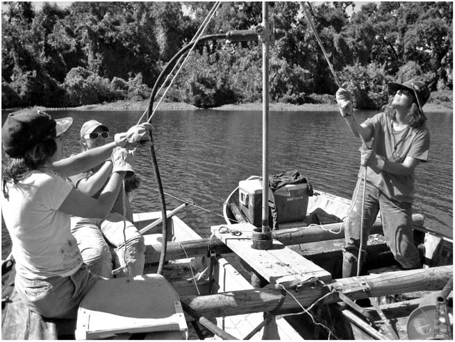
FIGURE 15. (Left to right) Frances Malamud-Roam, B. Lynn Ingram, and Christina Brady coring a small oxbow lake in the Sacramento Valley, California. (Photo taken by Anders Noren, University of Minnesota, LaCore curator.)
Lakes
Lakes are a common feature in the western landscape, and their sediments are important repositories of evidence about past climatic conditions gathered from the surrounding watershed. Particularly useful are lakes that grow and shrink with changing precipitation patterns, providing unique opportunities to assess the balance of rainfall and evaporation—a balance that changes markedly with differing climate regimes. These types of lakes, called closed basins, receive freshwater from inflowing streams and rivers and from direct rainfall, and they lose water only by evaporation from their surface.
An example of such a closed basin lake is Mono Lake to the east of the Sierra Nevada of California. Records of the size of Mono Lake over the past century and a half show that, during periods of more rainfall, the lake gradually expanded, whereas during periods of extended drought, the lake became smaller. This lake also contracted when the city of Los Angeles diverted water from its inflowing streams, starting in 1941. As the size of the lake changes, so does the elevation of its surface, measured as its lake level.
Earth scientists have devised a number of ingenious ways of assessing past lake levels in closed basins. For instance, the discovery of ancient submerged tree stumps rooted within some of these lakes has proved one of the most straightforward methods. We know that most species of trees are not able to germinate and grow with their trunks under water. Therefore, the existence of tree stumps submerged in a lake today indicates that, in the past, when the trees were living, the lake was much smaller than at present. A smaller lake implies lower precipitation and greater evaporation—thus, a dryer climate or a drought. By using the location of the tree stumps to estimate the size of the smaller ancient lake, researchers can estimate past inflow of streams relative to evaporation. In addition, by counting the annual growth rings of the submerged tree stumps, the duration of the past drought can be surmised. The death of the tree (when wetter conditions return, drowning the trees) can be determined using radiocarbon dating of the outer growth rings.
At the opposite extreme, during wetter periods, the locations of ancient lake shorelines can provide climate information. The shorelines of once-large lakes leave traces in the landscape in the form of wave-cut terraces, and these can be used to determine the size of prehistoric lakes and their surface levels. Furthermore, these terrace formations—and thus the time periods of the larger lakes—can be dated, again with radiocarbon or other radiometric techniques.
Recent technological advances have provided quantitative methods for deriving past lake levels. These include the methods used by geochemists on sediment cores taken from the bottom of lakes. Unlike tree stumps and ancient shorelines, sediment cores have the potential for providing a continuous record of changing lake size, not just the extreme highs and lows. Geochemists exploit the fact that, when a lake changes size during wetter and drier periods, its chemistry changes, and these changes are recorded in sediments or in the shells of organisms that precipitated from the lake water. During drier climates, rainfall is reduced and more water evaporates off a lake, thus concentrating the dissolved salts in the lake and causing certain minerals, such as carbonate and gypsum, to precipitate out of the lake water. These minerals then settle to the bottom, providing a layer indicative of a drought. Similarly, certain forms of elements in lake water become more concentrated during evaporation.
One such element that is commonly used by geochemists is oxygen. Geochemists measure two forms, or isotopes, of oxygen (oxygen-16 and oxygen-18) incorporated into calcium carbonate minerals that precipitate in the lake or constitute the shells of organisms that live in the lake. These minerals and shells record the relative amounts of the two oxygen isotopes (which have slightly different masses that can be measured in the laboratory on a mass spectrometer) as they form and settle to the bottom of the lake, where they accumulate and preserve this information. During dry periods, more water evaporates off the lake surface than is replenished by river inflow. Evaporation causes the lake water to become more enriched in oxygen’s heavier isotope (oxygen-18). During wetter periods, rain and runoff into the lake are greater than evaporation, so the lake grows larger, and the lake water becomes more enriched in the lighter oxygen isotope (oxygen-16).
Estuaries
Estuaries, where rivers draining the land meet the sea, also contain rich records of past climatic and environmental change. For instance, the San Francisco Bay estuary has formed where the rivers draining the Sierra Nevada merge and flow together, mixing with marine waters from the Pacific Ocean. The volume of this freshwater inflow, reflecting precipitation and runoff in the bay’s watershed, alter the bay’s salinity. The salinity changes in turn alter the types of organisms living in the estuary—from single-celled plankton and foraminifera to invertebrate organisms like clams and mussels. When these organisms die, they settle to the bottom, their hard parts becoming entombed in the sediments, later to be brought to the surface and examined by geologists and paleontologists.
Paleontologists analyze the assemblages of fossil remains and how these have changed over time to assess changes in the estuarine environment. The geochemistry of these fossil shells also reflects the environmental conditions of the bay water, particularly the salinity and temperature. As these organisms grow and secrete a calcium carbonate shell, they incorporate elements from the water surrounding them, including oxygen. Tiny variations in the mass of these oxygen atoms can be used to provide information about past environments. River water entering San Francisco Bay through the delta is lighter than Pacific Ocean water that enters the bay through the Golden Gate, meaning it has a higher proportion of oxygen-16 compared to oxygen-18. By analyzing fossil shells separated from cores taken beneath the bay from a range of ages, a time series of past salinity can be determined, providing a long history of climate over the entire watershed draining into the estuary.
Vegetation and Plant Assemblages
Anyone who suffers from hay fever dreads the spring, when the air is full of pollen—the dust-sized gametes made by the male part of the flower. All vascular plants produce pollen in differing quantities, but not all plants disperse it in the same manner. Some plants, using showy flowers, attract insects that disperse the pollen as they fly from plant to plant, collecting food. Others produce massive quantities of pollen and release it into the wind, some of which eventually comes to rest where it can fertilize another flower. Successful as this strategy is for the plant species, the majority of the pollen never makes it to other plants.
The “leftover” pollen has proven to be a tremendous resource for scientists who are looking for clues to the past. A portion of the pollen carried by the wind eventually ends up in lakes, marshes, and even the coastal ocean, where it is incorporated into the accumulating sediments. Pollen has a naturally resistant exine, an outer wall that protects the genetic information on the inside needed for the job of fertilization. When pollen accumulates in the right depositional environments, the exine remains well preserved and recognizable for long periods of time.
For scientists, pollen grains are like fingerprints: they are unique to each plant species or genus and, ideally, identifiable by their shapes and surface markings. Equally important, the types and proportions of pollen in the sediments provide information about ancient plant assemblages and therefore about past climate conditions. As forests, grasslands, and deserts and their various combinations of plants respond to changes in climate such as temperature and precipitation, the changing mix of pollens produced paints a picture of that climate. For instance, a pollen specialist would draw very different conclusions about a past climate from sediments containing pine and spruce pollen as compared to those containing oak and sage pollen.
Wildfires
Charcoal is also found in sediments from lakes and the coastal ocean, providing information about the size and frequency of past forest fires. These fires—though sometimes catastrophic—are a natural consequence of climate, particularly in the higher elevations of the American West.
Periods of prolonged drought typically create conditions that result in larger and more frequent fires, which produce large amounts of charcoal that are carried by the wind and surface runoff into lakes, ponds, and the coastal ocean. The abundance, size, and nature of charcoal in sediment are used to assess the history of wildfires in regions throughout the West. This area of study has received much attention, with interest fueled by the growth in population and economic importance of these mountain areas. As we will see in later chapters, some of these records show a disturbing pattern of recurring large fires throughout the region.
Trees
Earlier in this chapter, we discussed how trees contain evidence of climate histories within their trunks. In addition to bristlecone pines, many other trees contain valuable information about past climate. Trees have unique attributes as paleoclimate archives: they stay in one place for centuries or even millennia, adding new growth layers, or rings, to their trunks every year. Scientists who understand the specific biological needs of particular tree species and the ecological setting of the study area use trees to “measure” ancient rainfall and temperature patterns.
Of course, no single tree contains a complete climate history. Typical tree-ring climate chronologies require dozens of individual trees in each study site, and typically several study sites are needed to produce an accurate regional climate history. To avoid cutting down large numbers of trees, researchers have devised a nondestructive method of extracting small-diameter wood cores that causes no harm. These cores are obtained by drilling through the bark from the outer edge of the trunk to the center. The extracted cores, as narrow as long pencils, are scanned into a computer, and the yearly growth rings are counted and measured. The width of the rings provides a measure of annual weather conditions. Good years (for the West, this usually means wet with a long growing season) produce wider rings, and poor years (drier and cooler) produce narrower rings. During years of extreme drought, rings may even be absent.
TELLING TIME: DATING AND AGE CONTROL
Age control is an important aspect of reconstructing past climate change. Age determinations of sediment samples from cores or other recorders of past environmental change are critical for placing the records into a larger paleoenvironmental picture and for comparing different types of records from different locations. Researchers can also use age information to calculate how quickly climate changed in the past. These past rates of change provide a context for climate changes occurring today.
Establishing a chronology for climate records is challenging, but paleoclimatologists have devised a number of techniques. The ideal method provides annual time resolution, like the annual growth rings that trees produce, which can be counted to provide highly accurate ages. Similarly, corals, mollusks, and other organisms typically secrete annual growth bands when forming their hard parts. The deposition of sediments in lakes or coastal ocean settings during certain seasons can also yield annual time resolution in the form of annual layers. As discussed above, the varves of the Santa Barbara Basin provide a good example because these layers are deposited annually, so can be counted.
More typically, though, climate records contained in sediments from the sea floor, lakes, estuaries, and marshes do not contain annual varves. Most of these sedimentary sequences require the use of radiometric dating, which is based on known rates at which certain naturally occurring radioactive isotopes decay. The familiar radiocarbon (carbon-14, also known as C-14) method is the most common approach used for samples younger than 50,000 years old. Radioactive carbon is produced in the upper atmosphere when cosmic rays directed at the earth interact with nitrogen, transforming nitrogen-14 into carbon-14. Radiocarbon, just like the more abundant (and stable) forms of carbon (carbon-12 and carbon-13), combines with oxygen to form carbon dioxide and is eventually taken up by plants during photosynthesis. Carbon-14 also dissolves into the surface waters of the ocean, where organisms use it to build their calcium carbonate shells. Once these organisms die and become incorporated into the sediment, the radiocarbon begins to decay back to nitrogen. We know the rate of decay, so we can use the initial concentration, rate of decay, and amount of radiocarbon measured in our sample to give us the age of the sample.
For sediments older than about 50,000 years, scientists can use other radiometric methods to date other components of the sediment, such as mineral grains from volcanic ash that were produced during ancient volcanic eruptions. The ash is commonly deposited in distinct, thin layers within the sediment. Another approach uses the chemical “fingerprint” of an ash layer, allowing it to be traced to a specific volcanic eruption that has been independently dated. Volcanic activity has been a common occurrence in the American West over past millennia, so ash layers are widely used in dating lake sediments.
AGE RESOLUTION
The precision with which a researcher can resolve time within a paleoclimate record, or “age resolution,” determines the level of detail that can be reconstructed. Tree-ring records with annual resolution allow researchers to derive long histories of events that have a recurrence rate of less than a decade, such as El Niño events. At the other end of the spectrum, slowly accumulating sediments in the deep ocean may provide information only about climate shifts that occur over centuries or millennia. One of the primary factors in age resolution is the rate of growth (of a shell, for example) or accumulation (of sediment).
Sediments deposited in anoxic, partially enclosed coastal basins, such as the Santa Barbara Basin, and certain lakes accumulate at a relatively high rate of several centimeters per century. In these sediments, researchers can sample the varves and achieve annual time resolution. In the deeper parts of the oceans, far from land, sediments accumulate at a much slower rate—on average one centimeter per thousand years. These deeper ocean environments are usually higher in oxygen, and therefore some burrowing and churning by bottom-dwelling organisms searching for food means that the sediments will have been stirred, or “bioturbated,” blurring the record and averaging conditions over centuries or longer. In deep ocean sediment, time resolution can be limited to thousands, or even tens of thousands, of years.
The pollen record contained in lake cores provides a sequential history of vegetation. However, because pollen accumulates very slowly, less than a quarter of a teaspoon of pollen collected for analysis may represent several decades of accumulation. Hence, the age resolution for pollen studies is normally no better than decades to centuries.
Time resolution also depends on the accuracy of dating methods. Sediments dated using radiocarbon or other radiometric techniques have age uncertainties of thirty years to upward of hundreds of years, depending on the age and environment of deposition. In some cases, age measurements can be done only at irregular intervals, in which case ages for most of the sediment core must be interpolated from just a few layers that are suitable for dating. Examples of such sporadic or opportunistic age measurements would be an ash layer that can be matched to a volcanic eruption of known age, or the first appearance of the pollen of an introduced species, such as eucalyptus.
In the next five chapters, the methods reviewed in this chapter will be essential in understanding how scientists have pieced together the history of climate over the past 20,000 years. We then turn to the more challenging questions of what causes climate to change over shorter and longer timescales and why these changes are often periodic in nature. Looking ahead to the concluding chapters, we shall also see that both accurate methods and a good understanding of past climate change will be needed to address the most difficult question of all: What will the nature of the climate of the American West be in the future, and what will it mean for the region’s water resources?