NINE
The Great “Medieval Drought”
When we move beyond Europe and the North Atlantic into drier environments and lands with unpredictable rainfall, we enter a Medieval world where drought cycles and even a few inches of rain could make all the difference between life and death. While Europe basked in summer warmth and the Norse sailed far west, much of humanity suffered through heat and prolonged droughts. Archaeology and climatology tell us that drought was the silent killer of the Medieval Warm Period, a harsh reality that challenged human ingenuity to the limit.
BRIAN FAGAN, The Great Warming
THE COOL, MOIST CONDITIONS of the Neoglacial period ended in the late Holocene, with the climate becoming drier and warmer beginning about 1,850 years ago and continuing for more than 1,000 years. Although the general trend in climate in the modern-day western United States was toward dryness, conditions also became more variable: prolonged droughts were interspersed with sudden excursions of extreme wetness. The paleoclimate record of the past 1,800 years contains many examples of such climate swings, and, though both ends of the climate spectrum are of concern, it is the prospect of extended drought that most worries water planners in the West today.
A period that included episodes of extended and severe dryness began in about AD 900 and lasted until about AD 1400. Sometimes referred to as the “Medieval drought” in the western United States, this period was marked (in some regions of the West) by two prolonged “megadroughts” separated by a wet interval around AD 1100–1200. These droughts are considered by many paleoclimate investigators as possible analogs of the protracted droughts the West could face in the future and, as such, they provide an important impetus for water sustainability planning.
We begin this chapter by looking at the demise of the Ancestral Pueblo civilization in the Southwest, which occurred near the end of the Medieval drought period. This example shows how the megadroughts affected early human societies of the region. Our attention then turns to the physical evidence for the megadroughts and the impacts they had on the ecosystems and coastal populations of the West.
THE ANCESTRAL PUEBLO COLLAPSE
An advanced agricultural society once flourished in the American Southwest, over a thousand years before air conditioning and massive public water works made this region hospitable to our modern society. How could such a hot, dry region have become a vibrant center for ancient societies without the technological advantages we enjoy today? More curiously, why did this society apparently collapse at its peak of sophistication and population? Since first discovering the ruins of the Ancestral Pueblo—the collective name given to the early people of this region formerly known as the Anasazi—scientists have struggled to answer both questions.
Much of what archaeologists know about the Ancestral Pueblo comes from pueblo and cliff dwelling sites from the Four Corners region, including Chaco Canyon in northwestern New Mexico, Mesa Verde in southwestern Colorado, and Canyon de Chelly in northeastern Arizona. Archaeologists have used the deteriorating remains of adobe pueblo walls, artifacts, pottery shards, preserved food, soils, clothing, animals, and the skeletal remains of the people themselves to reconstruct this culture and better understand its collapse.
Chaco Canyon in New Mexico was the site of one of the most extensive Ancestral Pueblo settlements. By the ninth century, a warmer and wetter climate allowed populations in this region of the Colorado plateau to expand. At its peak, during the eleventh and early twelfth centuries, Chaco Canyon was elegant, with great pueblos the size of modern apartment buildings housing hundreds of residents in large, high-ceilinged rooms. Enclosed within these great houses were plazas and special circular sunken rooms, called kivas, where people slept and worked. The Ancestral Pueblo settlements were cities in many respects, supported by agriculture, which had begun as early as the second century and allowed people to settle in one place year-round. These early farmers planted corn and a variety of vegetables, and, over the decades and centuries, agriculture expanded onto the higher mesas to feed the growing population. Most of this farming depended on annual rains, supplemented by water from nearby streams and springs. Over time, however, the climate became increasingly arid and unpredictable; the Ancestral Pueblo farmers were forced to develop ways to divert water from rivers and even devise ways of storing it for future use. The residents of Chaco Canyon built an extensive system of diversion dams and canals, directing rainwater from the mesa tops to fields on the canyon floor, allowing them to expand the area of arable land.
With the help of this early water development, Chaco Canyon grew into a complex center of Ancestral Pueblo culture during the tenth and eleventh centuries. Water diversion features found in Chaco Canyon include terraced cliffs, ditches, overflow ponds, and masonry irrigation canals and dams. The Ancestral Pueblo were primarily agricultural, depending on their primary crops of corn, beans, and squash, which were supplemented with occasional hunting and the gathering of wild plants.
For centuries, the Ancestral Pueblo society thrived, closely connected to the natural climatic rhythms of the region. The summer monsoons provided sufficient water during the growing season, and, in the occasional years when the monsoons failed, residents relied on food reserves kept in large storage rooms in the great houses. The population in the Four Corners region swelled throughout the eleventh and twelfth centuries—until things began to go wrong.
Farther to the west in southern central Arizona, the Hohokam people settled near the confluence of Arizona’s only three rivers—Gila, Verde, and Salt. This culture initially practiced floodwater farming on the Gila and Salt rivers. Each year, they planted crops in the wet floodplain soils after the spring floods overtopped the riverbanks and spread water and nutrient-rich silts and clays in a manner analogous to ancient farmers thousands of miles away along the River Nile.
Within fifty years or so, the Hohokam had developed a new technology, canal irrigation, which began with the construction of small canals close to the rivers for transporting water to the fields. The Hohokam civilization thrived in central Arizona for a thousand years, building an extensive network of integrated canal systems that were capable of transporting large volumes of water long distances. The largest canals were twenty-four feet wide, nineteen feet deep, and twenty miles long—capable of irrigating over 10,000 acres of land. The engineering of these complex canal networks is considered to be the Hohokam’s greatest achievement, and the irrigation systems of the Hohokam are considered the best in prehistoric North America. Their success allowed them to expand across a large region of Arizona, from modern-day Tucson to Flagstaff, a distance of 260 miles. At the peak, an estimated 40,000 Hohokam lived in Arizona, but they suddenly vanished in the mid-fifteenth century.
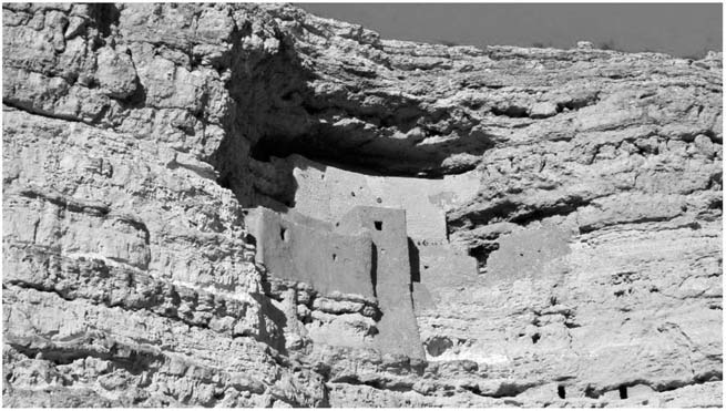
FIGURE 22. Montezuma’s Castle, a cliff dwelling located just north of Camp Verde in central Arizona. (Photo by B. Lynn Ingram.)
Another culture, the ancient Sinagua (which translates to “without water”), flourished farther to the north in Arizona, in the region between Phoenix and Flagstaff today. The Sinagua initially controlled water for their crops using check dams—small walls built of stone across ephemeral streams—and irrigation ditches. Over time, sediment and water accumulated behind these dams, providing fertile soil for planting crops. The Sinagua built storage reservoirs for domestic uses of water, such as washing, cooking, pottery making, and drinking. They also took advantage of natural water reservoirs, thriving in an arid environment for a thousand years. They built cliff dwellings near Camp Verde, Arizona (such as Montezuma’s Castle), which suggests that, as resources became scarce, they were forced to build fortified dwellings with hidden food storage areas to protect their meager supplies (see figure 22). The Sinagua also disappeared very suddenly, at about the same time as the Hohokam.
Looking closely at the demise of these ancient civilizations, we find many similarities. In particular, all of these societies were flourishing prior to a rather abrupt collapse. The archaeological record of the last decades of the Ancestral Pueblo in Chaco Canyon abounds with evidence of suffering: skeletal remains show signs of malnutrition, starvation, and disease; life spans declined; and infant mortality rates soared. Chilling stories of violence, possibly warfare, were told by mass graves containing bones penetrated with arrowheads and teeth marks and skulls bearing the scars of scalping.
Piles of belongings were found, apparently left behind as the people abandoned their settlements and fled, some to live in fortified hideouts carved in the cliff faces, protecting their hoarded food from enemies. The population of the region is known to have plummeted by 85 percent in a short span of time, but the causes of the collapse are still debated. Many make the case that climate was clearly a factor. In this chapter, we explore some of the climate evidence for drought, beginning with marshes along the California coast.
DROUGHT EVIDENCE
San Francisco Bay
Vast tidal marshlands have grown up around the edges of San Francisco Bay for roughly 6,000 years, after sea levels began to stabilize. The slower rate of sea-level rise allowed marshes to establish themselves and keep pace with the encroaching water. As the marshes continued to grow, their annual remains accumulated, decomposing slowly in the anaerobic conditions below the surface and forming peat. These marsh peats are important climate archives for scientists, safeguarding information about climatic and environmental conditions over the millennia.
The San Francisco Bay is like a “funnel” for water draining Northern and Central California out to the Pacific Ocean. The bay and its watershed can be seen in dramatic clarity in satellite images, which show a web of river tributaries from the Coast Ranges and the Sierra Nevada to the Central Valley toward the bay. Fifty miles inland from the Golden Gate, these rivers converge to form the Sacramento–San Joaquin Delta, where the waters mingle and flow through the bay and out Golden Gate to the Pacific. Within San Francisco Bay, fresh river water meets and mixes with the incoming ocean water, producing a range of salinity: fresh in the delta, saline in the central part of the bay near the Golden Gate, and brackish (intermediate) in between.
Brackish waters provide unique habitats for plants growing in adjacent tidal marshlands, creating more diverse plant communities than either the salt marshes near the Pacific Ocean or the freshwater marshes of the delta. The plants and organisms living in these tidal marshes must be adaptable: the daily tides bring in not only more water but more salty water. Furthermore, the annual march of the seasons brings changes in overall salinity as well, particularly in this region marked by wet winters and dry summers.
These annual cycles are superimposed on the year-to-year variability in salinity, reflecting variations in climate patterns. A drought in the watershed, if prolonged and severe, can cause higher salinity downstream in the estuary as the inflow of freshwater drops. In response, salt-tolerant species in the marshes expand further inland toward the delta, and the freshwater species retreat. Conversely, unusually wet winters generate fresher conditions in the estuary, leading to an expansion of freshwater-adapted species.
On the basis of this relationship between rainfall and wetland species in the estuary marshes, Roger Byrne, a Geography professor at the University of California, Berkeley, reasoned that a history of marsh plant assemblages could be used as a proxy record of past climate conditions, particularly for droughts and wetter periods experienced over the whole watershed. Such a history of vegetation could be produced from the evidence buried in the marsh sediments, which have accumulated abundant organic plant remains over thousands of years. Byrne invited the research group of this book’s authors to collaborate on this ambitious project, and together we cored marshes along the edges of San Francisco Bay across a range of salinities between the delta and the Golden Gate, with the goal of assessing past climate regimes over California as recorded by the marsh ecosystems (see figure 21 in the preceding chapter).
A number of proxy climate indicators were used in the project. For instance, pollen from the marsh sediment cores was used to assess past vegetation change. This pollen was extracted from the sediments, in addition to seeds and other vascular plant remains that had been deposited on the marsh surface over the millennia. Snapshots of the ancient plant assemblages were created from each layer, providing clues about the climate.
Suisun Marsh, located midway between the delta and the Golden Gate, provides a particularly sensitive record of climate change. By AD 1850, the wetlands surrounding Suisun Bay represented the most extensive area of brackish marsh on the west coast of North America. These marshes have experienced rapid losses since that time, as over 90 percent of Suisun Marsh has been filled for urban development and agriculture. Our study site in the northern part of Suisun Bay, called Rush Ranch, was a small, relatively pristine relict of the Suisun tidal marsh. By assessing the pollen remains in the sediment cores, we could determine the percentage of marsh plants adapted to higher salinity—such as saltgrass (Distichlis spicata) and cordgrass (Spartina foliosa), the so-called Chenopodiaceae—relative to those adapted to fresher conditions, like tules, cattails, and rushes, to assess the salinity conditions in past periods when the plants were growing. We knew that the marsh vegetation responds quickly to the changing salinity of freshwater inflow.
Our research project also involved the measurement of carbon isotopes from partially decomposed plant remains in the marsh cores as another way of deciphering changes in marsh vegetation. Nearly all carbon atoms have an atomic mass of 12 (carbon-12), but a small number of them have a mass of 13 (carbon-13). During times of drought, Suisun Bay would have been a saltier place, because less freshwater would have entered from the river. With higher salinity, the two salt-hardy marsh species, saltgrass and cordgrass, increased in dominance. Both of these species have higher proportions of carbon-13 relative to carbon-12, so their remains in the sediments could be detected using a mass spectrometer to measure the relative proportions of carbon isotopes.
Another important element of the research project included a third proxy tool: diatoms. Diatoms are microscopic phytoplankton that live in all aquatic environments, including marshes, and secrete a minuscule silica frustrule. Each diatom species produces a uniquely shaped frustrule, and these accumulate in the marsh sediments over time. Some species of diatoms prefer a more freshwater environment, whereas others prefer a more saline environment. By looking at the relative proportions of these diatoms in the sediment cores, our collaborator, paleontologist Scott Starratt at the U.S. Geological Survey, was able to provide an independent measure of water salinity in the marsh over time.
We dated the Suisun marsh core sediments using radiocarbon (carbon-14) measurements on the seeds of marsh plants separated from various levels of the core. This allowed us to establish a chronology delineating the vegetation changes detected through the pollen, diatom, and isotope analyses.
The results were compelling. They revealed that the salinity of the marsh increased (meaning the average freshwater inflow to San Francisco Bay was reduced) by close to 40 percent above today’s levels for a thousand years, between 1,750 and 750 years ago. The peak of this salty, low-inflow interval occurred approximately 1,200 to 900 years ago, during the early part of the Medieval drought. Only very low precipitation and runoff over San Francisco Bay’s vast watershed, covering almost half the area of California, could explain these results (see figure 23).

FIGURE 23. Stratigraphy of the sediment core from Rush Ranch, Suisun Marsh, in the northern San Francisco Bay. From left to right are the calibrated radiocarbon ages, the sediment types in the core, the diatom index, the percentage of Chenopodiaceae pollen, and carbon isotope values. The diatom index refers to the percentage of diatoms that live in higher salinity waters versus fresher waters. Values ranging between 0.00 and 0.30 are dominated by marine taxa, 0.31 to 0.70 are dominated by a mixture of taxa, and 0.71 to 1.00 are dominated by freshwater taxa. The Chenopodiaceae pollen (from marsh plants that grow in higher salinity waters, such as Salicornia and Atriplex) represents the percentage of that pollen relative to the total marsh pollen. The d13C value δ13 (plotted on the right) of fresher marsh plants is closer to -25 per mil, with those growing in higher salinity waters being closer to -15 per mil. The data show a higher salinity interval from 1750 to 750 years ago, encompassing the Medieval Climate Anomaly. (Graph modified using data from Byrne et al. 2001.)
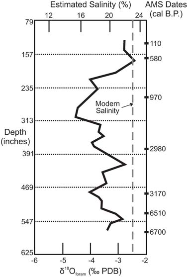
FIGURE 24. Oxygen isotope record from foraminifers from San Francisco Bay sediments, showing a shift to higher bay salinity (in parts per thousand) starting about 1,800 years ago and peaking 600 years ago. (Data from Schweikhardt, Sloan, and Ingram, 2008.)
Further evidence from San Francisco Bay sediment cores has been found for the major shift to a drier climate in California. The oxygen isotopic ratios (oxygen-18/oxygen-16) of calcium carbonate shells of microscopic, single-celled organisms (foraminifera) vary with salinity in the bay, as described in chapters 5 and 8. A research group that included Peter Schweikhardt and one of this book’s authors, B. Lynn Ingram, retrieved sediment cores from the central part of San Francisco Bay near Point Richmond. Along with micropaleontologist Doris Sloan, we chose one specific species of foraminifera that faithfully recorded salinity of the bay waters and was abundant over the past several thousand years, Elphidium excavatum. We carefully separated twenty to thirty of the tiny fossilized shells from successive layers in the core for oxygen isotope analysis on the mass spectrometer in our laboratory. When plotted against the shells’ depths and ages in the core, our measurements revealed that salinity in the bay began to shift from less saline waters to more saline conditions about 1,800 years ago, peaking in salinity about 600 years ago. These results corroborate those from Suisun Marsh—that dry conditions in California persisted for at least a thousand years (see figure 24).
Tales from Shrinking Lakes
Paleoclimate research throughout California has produced evidence that, taken together, adds up to some sobering results. In one study, sediments accumulating in an ancient lake located west of the Sierra Nevada revealed major periodic swings in precipitation. In the late 1980s, Scott Stine, then a graduate student in the Geography Department at the University of California, Berkeley, studied the geomorphic and sedimentary history of Mono Lake, a lake that has no natural outlet.
Stine was able to study the exposed delta sediments along the mouths of the streams that feed into the lake because these deposits were exposed between 1941 and 1990 when the inflowing tributaries were diverted to southern cities, causing the lake level to drop. More deposits were exposed during the drought of the late 1980s. Stine analyzed and radiocarbon dated the sedimentary sequences, delineating patterns of alternately higher and lower lake levels over the past 4,000 years. His results showed that, in the past 2,000 years, Mono Lake experienced an extended low stand that began about 1,600 years ago and remained relatively low, dropping to an even lower level between 1,050 and 550 years ago (see figure 20 in the preceding chapter).
Stine also discovered large tree stumps submerged in Mono Lake that were exposed when the lake’s surface dropped during the drought of the 1980s. These submerged tree stumps indicate that, at one time, the lake was so small that its shoreline was several tens of feet lower than the present level, allowing the trees now underwater to grow on dry ground. Just like the submerged tree stumps in Lake Tahoe (discussed in chapter 7), these stumps provide strong evidence for extended drought in the past.
A decade later, in the early 1990s, Stine discovered similar tree stumps in lakes, marshes, and rivers throughout the central and eastern Sierra Nevada, including Tenaya Lake in Yosemite National Park, Osgood Swamp, and the Walker River (see figure 25). These trees, mostly Jeffrey pines, are not adapted to soggy soil conditions, but the size of these stumps indicated that they had lived well over 100 years. Thus, they provided clear evidence that, at the time the trees were living, the level of Tenaya Lake must have been much lower than in recent times. Based on the amount the lake level must have dropped for these submerged trees to have grown on dry ground, away from the banks of lakes or rivers, Stine calculated that average annual river flows in the region were only 40 to 60 percent of what they were in the late twentieth century.

FIGURE 25. An ancient tree stump submerged in the West Walker River, eastern Sierra Nevada. (Photo courtesy of D. J. DePaolo, University of California, Berkeley.)
By counting the annual growth rings of these submerged trees, Stine showed that the trees had lived upward of 160 years. The droughts must have lasted at least that long to allow the trees to survive in that location. The trees were finally killed when the droughts ended abruptly, followed by dramatically high rainfall that rapidly raised the lake levels to drown them. Stine dated the outer growth layers of the tree stumps in Mono Lake and in other lakes and rivers in the central and eastern Sierra with radiocarbon methods. He found that the ages of all these trees clustered around two distinct periods: AD 900–1100 and AD 1200–1350.
Tree-ring studies from a broad region of North America indicate that climate conditions over the past 2,000 years became steadily more variable, with especially devastating droughts during this period as compared with earlier times. These records also suggest that the driest period in the West occurred between AD 900 and 1400. For instance, researcher Edward Cook and his colleagues at the Lamont Doherty Earth Observatory Tree Ring Laboratory in Palisades, New York, have studied tree-ring records that reflect the summer values of the Palmer Drought Severity Index—a measure of the moisture content of soil in the root zone. They compared tree-ring records from throughout North America and found that over half of the American West suffered severe drought between AD 1021 and 1051 as well as from AD 1130 to 1170, AD 1240 to 1265, and AD 1360 to 1382.
Medieval Climate Extremes
The Medieval drought included not only severe drought, as detected in the San Francisco Bay marsh records, tree rings, and tree stumps from Mono Lake and elsewhere in the Sierra, but also severe floods. In fact, several studies suggest that conditions were exceptionally wet in the interval between the two Medieval megadroughts (850 to 750 years ago). For instance, Carson Sink lakes in the Carson Desert of the Great Basin of Nevada reached their highest levels between 915 and 650 years ago. Using water balance models, researchers at the Desert Research Institute calculated that these lakes would have required four times the modern stream inflow for 70–80 years in order to reach such high stands. More evidence comes from the White Mountains of eastern California, where bristlecone pine growth rings indicate this to be the wettest period in the past 1,000 years. Tree rings from the southern Sierra Nevada also suggest exceptionally wet conditions during this period between the droughts.
Extremes in wet and dry during the Medieval period were not the only anomalies. The trees of the Sierra Nevada tell us that, for at least the latter part of the period, conditions were also warmer than average. Connie Millar, a research scientist for the U.S. Department of Agriculture, discovered the remains of trees that had been buried by the ash of a nearby volcanic eruption in the high peaks of the eastern Sierra Nevada 650 years ago. Several species of these trees were growing much higher in the mountains than they do today, suggesting that temperatures in eastern California were more than 3°C (5.4°F) warmer toward the end of the Medieval drought than today.
Millar’s results were supported by those of dendrochronologist and paleoecologist Lisa Graumlich when she was the director of the Laboratory for Tree-Ring Research at the University of Arizona. Analyzing tree rings from foxtail pines and western junipers in the southern Sierra Nevada, she found that the period between 900 and 625 years ago exceeded twentieth-century warmth.
Other scientists from the University of Arizona, including Connie Woodhouse and David Meko, studied trees in the Colorado River Basin. Their tree-ring data indicated a particularly warm and dry period during the mid-twelfth century, when average temperatures were 1.8°F above the long-term average and Colorado River flows were 15 percent below normal.

FIGURE 26. (A) Fire scars at the base of a mature Giant Sequoia trunk from the Sierra Nevada (http://commons.wikimedia.org/wiki/File:Fire_scars_in_sequoia_trunk). (B) A cut section of a Giant Sequoia trunk from Tuolumne Grove, Yosemite National Park, California, showing AD dates of fires (photo courtesy of Thomas Swetnam, Laboratory of Tree-Ring Research, University of Arizona).
Increased Wildfires
As conditions grew warmer and drier during the Medieval drought, wildfires would be expected to be larger and more frequent. Very large and old trees can provide a long history of past forest fires. Giant Sequoias (Sequoiandendron giganteum), the massive redwoods growing in about seventy-five distinct groves along the mid-elevations of the western Sierra Nevada, are among the most useful of such living archives. These spectacular trees can live up to 3,200 years or more and can exceed 250 feet in height and 35 feet in diameter. They can withstand numerous forest fires throughout their lives, and these fires leave behind scars (see figure 26). Thomas Swetnam, the current co-director of the Laboratory of Tree-Ring Research at the University of Arizona, discovered that these fire scars are visible on their annual growth rings and can therefore be used to assess the frequency of past fires.
Swetnam and his team sampled Giant Sequoias from five groves between Yosemite National Park and Sequoia National Park, far enough apart that individual fires could not have spread from one grove to the next. Using a chainsaw, they sampled cross sections inside the fire-scar cavities at the base of dead trees. The team dated the trees using ring-width patterns and recorded the fire scars contained within annual rings. Their analysis reveals that fires were more frequent from AD 900 to 1400—coeval with the Medieval Climate Anomaly, when an average of thirty-six fires burned every century. During the centuries preceding the Medieval period and immediately following it, the fire frequency was substantially lower, with an average of twenty-one fires per century (see figure 27A). These results are consistent with sedimentary charcoal analyses from Sierra Nevada meadow cores, which also show a marked increase in fire frequency during the Medieval drought (see figure 27B).

FIGURE 27. (A) Fire frequency in the Sierra Nevada based on charcoal abundances from sediment cores from five meadow or bog locations, compared with fire histories based on fire scars from Giant Sequoias. Note that fire frequency was lower prior to 2,300 years ago (300 BC) and particularly high during the Medieval period (AD 900–1600). Multidecadal-to centennial-scale fluctuations in fire frequency are also exhibited in the record. (B) Fire frequencies (solid line) and means of the Palmer Drought Severity Index (PDSI, dashed line) showing the close correlation between the two. Fire frequencies, mean summer temperatures, and PDSI all peaked at the end of the Medieval period and declined throughout the Little Ice Age. (Figure redrawn from Swetnam et al. 2009.)
IMPACTS ON THE SOUTHWEST
Archaeologists and climate researchers are increasingly often teaming up to understand the environmental conditions during key periods of past climate or environmental change. The environmental conditions can provide context and breadth for their understanding of the lives and fates of the ancient inhabitants of the West.
One such collaboration has been in the Four Corners region of the Southwest, where archaeologists have long observed the so-called “Anasazi collapse.” Tree-ring studies from this region show unusually narrow rings during the periods AD 1020–1050, AD 1130–1180, and AD 1276–1299. Each of these series of narrow rings reflects periods of slow growth, indicating drought, which corresponds to dramatic population declines in the Southwest as interpreted from archaeological evidence. For example, researchers studying the Medieval drought in New Mexico have produced tree-ring records that focus on summer rainfall for the region spanning the past 1,200 years. Their results reveal that the droughts from AD 1130 to 1180 and AD 1276 to 1299 were tied to failures of the summer monsoon rains.
A similar result was found in a pollen study from southwestern Colorado that focused on the prevalence of piñon pines, a common species in the area that depends on summer monsoon rains for seedling germination. The pollen record reveals a sharp reduction in seedling success in the region lasting over 400 years, from AD 1250 to 1650, indicating more failure of summer monsoon rains and less seedling establishment.
Larry Benson and his colleagues at the U.S. Geological Survey have recently examined the possible impact of this failure of the summer monsoons on the Ancestral Pueblo by comparing many proxy records of climate from throughout the region—including the tree-ring records in New Mexico and the pollen study from Colorado—to the archaeological records of Ancestral Pueblo migrations. Benson found that major human migrations occurred during prolonged periods of drought, particularly when the summer monsoons failed. To better understand how the droughts would have affected these populations, the team applied a model of maize production based on Zuni and Hopi agriculture as the closest approximation of the early Ancestral Pueblo agricultural practices. In this region, the crops were planted in the spring and depended on summer rains for water. The models show that, during multiple years of summer drought, annual harvests of maize would not have been sufficient to sustain human populations. Most likely, a good harvest would have yielded enough food for the current year, plus one year’s reserve, but no more. Multiyear failed harvests would have been devastating to the growing population.
There is evidence that human populations were feeling the impacts of these droughts throughout the Southwest. The archaeological record shows that populations at Mesa Verde in southwestern Colorado began building dams and canals, presumably to store and then transfer water onto terraced fields as a response to the decreased reliability of rainfall. The region was occupied between about AD 550 and 1275 before it was suddenly abandoned.
In Utah and western Colorado, the Fremont people vanished abruptly at the same time as the Ancestral Pueblo. In many cases, the populations fled to high cliff dwellings. Some of the evidence shows that as crops, particularly maize, began to fail, the people hid their limited food in storage chambers carved into the cliffs. These may have been last-ditch efforts to stave off collapse. The Sinagua culture in central Arizona also abandoned sites throughout the region following an occupation from AD 1125 to 1300.
THE IMPACT ON NATIVE CALIFORNIANS
The unusually dry climate during the Medieval drought appeared to have tested the endurance and coping strategies of even well-adapted native populations in California. Skeletal remains—bones and teeth—are used as indicators of the health and condition of these populations. They show that life in the interior of California was particularly difficult because the drought severely reduced sources of food (nuts, acorns, plants, deer, and other game). Settlements along rivers were abandoned, and trade between inland and coastal groups broke down.
As water supplies dried up, conflicts—even battles—between groups arose over territory and resources. Populations had grown in better times prior to the drought, leading to more territorial disputes and competition over oak groves. Along the Southern California coast and on the Santa Barbara Channel Islands, the Chumash Indians were then too populous to move during the drought as they had during earlier periods of dry climate. Skeletal evidence shows dramatic increases in malnutrition and diseases as well as projectile injuries and head wounds, interpreted as having been inflicted during warfare. This evidence, uncovered by anthropologists Patricia Lambert and Phillip Walker, indicates that deteriorating environmental conditions and dwindling food and water resources led to conflicts between the growing population.
On the whole, coastal groups appear to have fared better than inland groups because most of their food came from the ocean. Increased upwelling of nutrient-rich waters along the coast during this time increased marine productivity and expanded resources such as fisher and shellfish.
Freshwater was scarce, however, and all along California’s coast, including San Francisco Bay, sites were abandoned as the desperate populations wandered in search of new water sources. Kent Lightfoot and Ed Luby have speculated that coastal groups began moving over larger territories as resources became scarcer, perhaps alternating between inland and coastal sites on a seasonal basis. The mobility of these populations allowed them to endure this difficult period.
THE MEDIEVAL CLIMATE ANOMALY: A GLOBAL PHENOMENON?
Across the globe, the archaeological record contains examples of societies rising or falling during the Medieval period. The Ancestral Pueblo culture did not survive these changes, as we have discussed above, whereas others thrived. The fate of each culture seems to have been tied to its unique local situation. But the fact that so many regions experienced upheavals in the same period raises questions about larger-scale external influences during this period of history.
Paleoclimate studies throughout the Northern Hemisphere continue to fill in the details of regional climate from the ninth to the fourteenth centuries. While societies in the American Southwest were suffering catastrophic decline caused by drought, societies in northern Europe, where average temperatures were about 1.8°F warmer than today, were flourishing. This seemingly small increase in temperature was sufficient to unleash major historic events. Eric the Red was leading Norse settlers to Iceland and Greenland to establish colonies, and European farmers were expanding into new lands previously too cold to support agriculture—even planting vineyards in England. This era featured the growth of towns and city-states; science and art blossomed; trade expanded; and communication improved among countries. In Europe, the changes in climate fed the blossoming of societies. But in the American West, the changes in climate brought devastation.
We now see that the Medieval period, initially believed to be a worldwide period of unusual warmth, was not a uniform experience across the globe. In a seminal 1994 review of the topic, appropriately entitled “Was there a ‘Medieval Warm Period’ and if so, where and when?,” Malcolm Hughes and Henry Diaz came to the conclusion that the 500-year period of the Middle Ages was a time when various regions across the world experienced episodes of warmer temperatures, but not all at the same time. Furthermore, in some regions, including the southeastern United States, the Mediterranean, and parts of South America, there appeared to be very little change in average temperatures. The authors proposed that the misnomer “Medieval Warm Period” be replaced by the term “Medieval Climate Anomaly.” In this book, too, we will use the latter term in the remainder of our chapters.
The article was particularly timely for California and the West, since the 1980s and 1990s were marked by prolonged droughts alternating with extremely wet years with damaging floods. Many people, including water managers, were becoming increasingly interested in understanding the region’s climate. In this context, information about the lake-level and tree-stump history of Mono Lake and the increased salinities in San Francisco Bay provided stark warnings of how climate could affect our lives in the future.
BACK TO THE MARSHES
We return to the Suisun Marsh record because it shows that a long period, including the Medieval Climate Anomaly, was clearly drier in San Francisco Bay’s vast watershed than it was before or after. However, the marsh record lacks any evidence of the two “megadroughts” detected in the central to southern Sierra. To further understand the changes in the bay estuary’s watershed during these droughts, our research group took a second look at the San Francisco Bay marsh sediments, this time focusing on the clays and silts that wash into the bay from its watershed. These sediments carry mineral and chemical fingerprints of their origins, such as the volcanic rocks (mainly andesites) of the northern Sierra Nevada range and southern Cascades, or the granites and granodiorites of the central and southern Sierra. As these sediments are carried into San Francisco Bay, the largest particles settle to the bottom of the estuary while the finer, lighter ones are washed onto the surrounding marshes, forming steadily accumulating layers.
The Sacramento River drains the northern part of the watershed, carrying sediments from the northern Sierra Nevada and southern Cascades, and the San Joaquin River drains the southern part of the watershed. The mineral composition of the sediments is as valuable to paleoclimatologists as fingerprints are to police detectives, providing evidence of origin. The changing proportions of sediments from the northern and southern parts of the watershed provide details of how climate in Northern and Southern California has varied over time, and these changes have shown that the Medieval droughts were indeed felt throughout the watershed of the estuary, in both northern and southern portions—but not at the same time.
During the first of the megadroughts, which began around AD 900, the southern Sierra Nevada experienced the initial severe conditions. Run-off flows were so low that almost no sediments from that region reached the bay. In the northern portion of the watershed, conditions remained normal at first, and the Sacramento River flows continued to transport sediments. However, as the drought persisted, it spread northward, causing reduced flows of the Sacramento River and therefore bringing less sediment from that region to the bay. At the same time, flows from the San Joaquin River, draining the southern watershed, increased somewhat (around AD 1080). The second major drought (between AD 1200 and 1400) shows a similar pattern.
When we compare these results with tree-ring studies from the northern Sacramento River watershed and the southern San Joaquin River watershed, we see agreement: the droughts across California did not always occur at the same time, but alternated between the northern half and the southern half of the state. The Medieval Climate Anomaly was a period of unusual climate, but the impacts on precipitation over the American West were not uniform in magnitude, duration, or geographic location. What could have caused these unusually dry periods in the West?
CLUES FROM THE PACIFIC OCEAN
The search for the cause of this period of variability and climate extremes led researchers to turn their attention to the primary source of the American West’s climate: the Pacific Ocean. Some of the first clues emerged from the ocean just off coastal Southern California.
Sediments on the coastal ocean floor contain the remains of single-celled organisms that form calcite shells, called foraminifera (or “forams”), which contain information about oceanic conditions like sea surface temperature. Off the coast of Santa Barbara, these forams have been used to assess sea surface temperatures over the past ten thousand years using the oxygen isotopic composition of a particular species of foram, Globigerina bulloides. This species lives exclusively in surface waters, so its shell incorporates oxygen directly from the surface waters and faithfully records changes in ambient sea surface temperature. Analysis of these shells from cores broadly coincident with the Medieval period has shown that the surface water temperatures were 2–3°F colder from AD 700 to 1300 than they are today. Cooler than average waters in the eastern Pacific are often associated with La Niña conditions, which bring drought to the American Southwest, but more evidence from the tropical Pacific Ocean would be needed to confirm the connection during Medieval times. We will discuss this and other evidence for the ocean-atmosphere changes that occurred during this time in chapter 11.
In light of the evidence for a warm, dry period in the West between about 1,800 and 550 years ago, with particularly deep droughts toward the end of that period (from 1,050 to 550 years ago), current inhabitants of the western United States face sobering questions: How common are such severe and prolonged droughts? Do they represent the most extreme events we can expect? When will the next one strike? Will they be more frequent and severe as the region warms in the coming decades? How would they affect society today?
And what of the opposite climate extreme—the deluges and floods that ended the droughts? How often do these floods, with magnitudes similar to the 1861–62 event or even greater, recur? To further explore these questions, we turn next to the Little Ice Age. This cool period, which followed the Medieval Climate Anomaly and lasted until the nineteenth century, brought several megafloods of a magnitude that no one alive today has yet experienced.