FOURTEEN
What the Past Tells Us about Tomorrow
If future generations are to remember us with gratitude rather than contempt, we must leave them more than the miracles of technology. We must leave them a glimpse of the world as it was in the beginning, not just after we got through with it.
PRESIDENT LYNDON B. JOHNSON (said while signing the Wilderness Act, 1964)
AS SHOWN THROUGHOUT THIS BOOK, the American West faces a climatic future that is predicted to become generally warmer and drier, with deeper droughts interspersed with larger and more frequent floods. Scientists believe these shifts may have already begun, since the region is experiencing more extreme weather. Only time will tell, but greenhouse gas–induced warming may be at the root.
Reducing the uncertainty of future climate predictions requires an in-depth understanding of the natural patterns and range of climate, including the fluctuations of conditions experienced over the millennia prior to human-caused greenhouse warming. As discussed in the preceding chapters, a substantial body of research shows that the so-called “normal” range of past climate is enormously broad. Records of long-term climate underscore that, over the past 150 years, nature has dealt the western United States a relatively benign hand. If the decade- to century-long climate extremes written about in this book should revisit the region, modern society will be forced to make dramatic changes in the way we live.
Over the past century, society in the West has followed an unsustainable pattern of water use, leaving us more vulnerable each year as we head into a climatic future we cannot control. The exploding population in the region has been made possible through extensive water development, with dams and aqueducts controlling the distribution of water and buffering the dry years. Nevertheless, we cannot stop droughts from happening. The West is drying, even though water continues to be delivered to our faucets. Key questions probably keep regional water managers awake at night, among them: How bad can it get? How prolonged and severe the droughts? How massive the floods?
LESSONS FROM THE PAST
The truism that history repeats itself applies not just to the affairs of humankind but to climate as well. The climate history of the past 20,000 years reveals that the American West has been plagued by deep and prolonged droughts, as well as by enormous floods, on a fairly regular basis. Paleoclimate records from across the region, extracted from many sources discussed in this book—tree rings, sediment cores, lake levels, and sediment geochemistry, among others—have been compiled over the years to produce this history. Although some questions remain unanswered, the records have informed scientists of the range of climate conditions the region has experienced, including the frequency and magnitude of extreme climate events. These extreme events far exceed those experienced over the past century and a half. How likely are such events to recur, and are we prepared for these events today?
Droughts
During past periods of climatic warming, such as occurred during the mid-Holocene and again in the late Holocene, conditions throughout the West tended toward increasing dryness, with droughts that could stretch out for centuries. Research from California and the Great Basin, for example, shows that the mid-Holocene was dry for nearly 1,400 years. Humans occupied the American West during this time, and the archaeological record shows that the mid-Holocene warming coincided with mass migrations of native populations from the desert interiors of the West to the coastal regions. This long episode of warmer and drier climate was followed by the Neoglacial—a period of cooler and wetter climate.
In the late Holocene, beginning approximately 1,800 years ago, drying conditions returned, peaking during a particularly dry period from AD 900 to 1400 (the so-called Medieval Climate Anomaly). Prolonged droughts were a fixture during this drier millennium, as were intermittent floods. Combined, these extremes brought down flourishing civilizations that, the archaeological records show, all but disappeared as their agricultural bases withered. The scattered native peoples that were able to persist during these prolonged dry spells in the American West were also hard-hit by extreme floods, so they had to develop coping strategies. One key to their success was an intimate knowledge of their environment and its resources. Another was the size of their population: they survived by living in small, flexible groups, able to mobilize rapidly and relocate as conditions dictated.
The hardships suffered by these early human inhabitants of the West provide important lessons. For instance, during extended periods of abundant moisture, societies that grew rapidly were left vulnerable to collapse when the climate inevitably turned dry again. Modern society in the West has followed a similar path: after a century of fairly abundant moisture, the population in this region has exploded. Modern engineering has allowed the exploitation of all available water sources for human use, and water policy has favored water development for power, cities, and farms over sustainability of the environment and ecosystems. These policies have allowed populations to grow right up to, and perhaps beyond, the limits that this region can support, leaving it vulnerable should drier conditions return. In this respect, today’s society in the West resembles the Ancestral Pueblo of the twelfth century—both living beyond their means.
Paleoclimate records also reveal that the lack of prolonged droughts during the past 150 years is an aberration. In the past two millennia, such droughts, some of which lasted several decades, occurred at intervals of every fifty to ninety years. The longest droughts experienced by the West over the past century—lasting about six years—are meager by comparison. Certainly, however, as discussed in chapters 1 and 3, these relatively short droughts brought extreme hardship to the region.
Climate scientists have discovered a new complication in the West. In addition to that region’s variable climate, scientists agree that a warming trend has been superimposed on it—a trend that began a few decades ago and is likely caused by a rapid increase in carbon dioxide (and other greenhouse gases) in the atmosphere. The American West appears to be facing a potential climatic double-whammy: a cyclical return of the drier conditions and a new greenhouse gas–induced warming. Although we do not know exactly what kind of weather this combination will produce, climate models indicate that global warming will compound natural climate cycles and that a warming world will likely make the extreme events, particularly floods and droughts, even larger and more frequent.
Floods
The paleoclimate records suggest that the West has experienced far worse floods, at regular intervals, than the region has seen over the past 150 years. The 1861–62 flood, for instance, was the result of a series of large storms that flowed one after another across the Pacific in what climatologists describe as an atmospheric river. These storms slammed the West Coast—from the Mexican border to Canada—for 43 days, bringing triple the average amount of rainfall to the region and leading to unprecedented flooding. Based on the relatively short historic record, water planners have estimated that a flood of this magnitude may recur perhaps every thousand years. However, paleoclimate records spanning the past two thousand years indicate that floods of this magnitude, or perhaps larger, have recurred every one to two centuries.
The largest of these floods occurred during the Little Ice Age, four hundred years ago. This event predated the history of modern California, yet it is interesting to note that Native American residents in 1861–62 appeared to recognize the early warning signs of these storms and the subsequent floods, and they quickly moved out of the floodplains and up to higher ground. Their long history in the region had given them a deeper understanding that, though the floodplains could provide abundant rich soils and resources, they could only be safely occupied seasonally. The Native Americans knew better than to build permanent settlements in California’s Central Valley or delta.
FUTURE FLOOD RISKS
California’s Central Valley
Many regions in the western states are vulnerable to flooding today, despite decades of construction of flood control infrastructure. Modern society has promoted growth, with cities sprawling out onto the floodplains, deltas, and other low-lying areas. Many of these regions are protected by aging levees that have been shown to fail under larger flood events.
Other human activities have added to the flood risk. Take, for example, California’s Central Valley: viewed from above, it looks like a giant bathtub—up to 400 miles long and 70 miles wide—with the San Francisco Bay estuary and delta as the drain. Most of California’s agriculture, and much of its future population growth, will occur there. Early accounts from California history describe winter floods, like the 1861–62 event, that turned the Central Valley into an inland sea. Floods have been a natural feature of the Central Valley for millennia, which is why the soils are so rich and fertile. However, flooding on this scale does not mix well with the interests of a modern agricultural system that depends on regularity and controlled water supplies, or with the inland cities that are now replacing them.
Over the past century or so, Californians have prevented these catastrophic floods through massive hydro-engineering projects. Water managers have essentially taken nearly full control of the timing and amount of water that reaches the fertile lands within the Central Valley. The consequence of this transformation of the natural hydrology, combined with groundwater pumping, soil compaction, and the draining of wetlands, has been that much of this vast region has sunk by several feet and, in some areas, by as much as 28 feet.
Today, this sunken region may be more susceptible to flooding than it was in 1861–62. Moreover, the population of California has grown from 300,000 in 1861 to over 37 million in 2012, a number that is expected to double by the year 2050. Room has to be made for this swelling population in the future, and people have been finding that space in the Central Valley. Increasingly, the region has been providing more affordable housing, with former agricultural lands in the Central Valley floodplains being converted to housing developments. Should floodwaters fill the Central Valley, they will submerge not just small towns, marshes, and farmlands but also major population centers in ten to thirty feet of water. In 2009, over six million people lived in the Central Valley, many in densely populated cities like Modesto, Fresno, Stockton, and Sacramento, all of which face potential catastrophe should storms and floods like the ones in 1861–62 strike again. The recent trend in urban sprawl seems to dance on the edge of disaster: flooded fields are one thing, but flooded homes are quite another.
The long history of megafloods in the Central Valley is virtually unknown to most residents today. Many new cities and housing developments are protected by a relatively primitive network of levees—some 6,000 miles of levees in all—that line the rivers. These levees are fragile and they are the last—and in some cases only—line of defense against the potential floods spilling out from the Sacramento and San Joaquin rivers. The fragility of California’s levees has repeatedly been exposed in recent years. During the winter of 1986, floodwaters overwhelmed Folsom Dam on the American River and almost flooded Sacramento; in 1997, levees broke throughout the Central Valley, causing the largest evacuation in California’s history; and in 2006, multiple levee breaks and massive flooding in the Central Valley made national news.
The Delta
The Sacramento–San Joaquin Delta is located inland of San Francisco Bay on the western edge of the Central Valley, at the confluence of the Sacramento and San Joaquin rivers. These rivers drain a watershed covering almost half the area of California, including the southern Cascade range to the north, the western flank of the Sierra Nevada, and the eastern flank of the Coast Ranges. Wet winters bring huge volumes of water to the delta—a region now considered a disaster waiting to happen.
The delta was once a 700,000-acre network of wetlands and channels, with seasonally shifting river inflows, and host to millions of migrating birds and fish as well as animals such as elk and grizzlies. During the Gold Rush, however, the delta’s natural wetlands were drained and converted to farmland to feed the growing population in San Francisco. Islands in the delta were formed, protected by levees built by farmers, Chinese laborers, and miners, using wheelbarrows, picks, and shovels. These earthen levees confined river flows to the channels, so that the wetlands on the newly isolated islands no longer received sediments or nutrients.
Over time, the sediment debris on the wetlands that had accumulated over centuries dried, oxidized, and decomposed. Winds blew the dried peats away, causing the islands to subside by up to twenty-five feet below sea level. The levees separate the channeled waterways through the delta from these now-sunken “islands.” In recent years, over half a million homes have been built on these islands in the delta, yet many of the new occupants are unaware of the substantial flood risks. As the levees continue to age, they are becoming more prone to failure during floods and even earthquakes. In 2004, a 350-foot section of a levee ten miles west of Stockton collapsed, flooding a 12,000-acre island called the Upper and Lower Jones Tracts (see figure 35). As discussed in chapter 12, a breach in a levee in the delta also has the potential of allowing seawater to intrude into the freshwater supply that is pumped to residents in Southern California as well as to farmers in the San Joaquin Valley.
California’s capital city of Sacramento, located just north of the delta along the Sacramento River and just downstream of the Folsom Reservoir, is also at the mercy of levees that are over a century old. This city, which was under ten to twenty feet of water in the 1861–62 flood written about in chapter 2, has the lowest level of flood protection for an urban area anywhere in the United States, despite its dramatic flood history. With flood protection well below that of New Orleans, a large flood in the Sacramento region could result in tens of billions of dollars in damage and put thousands of lives at risk.
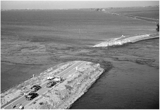
FIGURE 35. Sacramento-San Joaquin Delta levee break in June 2004, which flooded a 12,000-acre island in the delta. (Photo courtesy of the California Department of Water Resources.)
AN ATMOSPHERIC RIVER “SUPERSTORM”
Recent research shows that atmospheric river storms have produced the largest historical floods along the Pacific Coast states of California, Oregon, and Washington. As the global climate warms over the next century, larger and warmer atmospheric river storms (and extended storm seasons) are predicted. From a flood-risk perspective, this is bad news.
The U.S. Geological Survey has published a new emergency-preparedness scenario called “ARkStorm” (standing for Atmospheric River 1000 Storm). This scenario assesses the extent of damage that would result if a hypothetical series of atmospheric river storms, analogous to those that struck in 1861–62, slammed the West Coast today. The ARkStorm scenario shows that flood control systems would be overwhelmed, and Sacramento, as well as the expanding cities and populations in California’s Central Valley, delta, and other low-lying regions, would be almost entirely underwater in a “Hurricane Katrina–like” disaster. The ARkStorm scenario also indicates that hurricane-force winds would strike the coast, in some places reaching 125 miles per hour. As slopes and hillsides become quickly saturated, the ensuing landslides and mudflows would cause widespread damage to roads and property. This scenario suggests that one-quarter of all homes in California would be destroyed and an estimated 1.5 million residents would be forced to evacuate the Central Valley and the San Francisco Bay delta.
The total cost to California in this scenario, including business interruption and property repair costs, could reach $725 billion, which is three times the estimated cost of a large Southern California earthquake. The U.S. Geological Survey considers this extreme storm scenario to be the next disaster waiting to happen—even more catastrophic than the next big earthquake predicted to strike the region. The ARkStorm team has raised public policy questions, including whether to fund emergency preparedness and atmospheric river–prediction studies, and it recommends that steps to mitigate the impacts of this scenario should begin immediately to prevent catastrophic loss of life and property.
We now have the ability, as a society, to understand climate and forecast weather. We also have deeper insights into the impacts of extreme climate events on our world. It is time for individuals and society to change our behavior in order to mitigate the effects of these events. One important step would be to allow our floodplains, marshes, and deltas to resume their natural functions. Each year, the oceans rise higher, and some scientists suggest that the best protection from the dangerous combination of rising sea levels and extreme storms is what nature has already provided but we have nearly eliminated: tidal wetlands.
In California before the Gold Rush, for example, the San Francisco Bay delta was surrounded by 849 square miles of tidal wetlands. Not only did these wetlands provide unique habitats for millions of migrating and resident birds, mammals, and fish, but the lush vegetation also slowed storm-driven waves, dissipating their energy. Today, only about 48 square miles of the wetlands remain, and these remnants are among the most threatened ecosystems in the state. An urgent question is whether these marshes can keep pace with the rising sea. The sediments delivered to the marshes may prove inadequate to keep the surface above water, and the marshes may no longer have the option to retreat landward, as they are now completely surrounded by urban sprawl.
TAKING A “NO REGRETS” APPROACH
Most water experts urge policymakers in the West to begin taking action immediately to prepare for both ends of the climate spectrum facing the region: drier conditions and decreased water availability interspersed with longer storm seasons leading to larger and more frequent floods. Although it is not yet clear to what degree the drought conditions in the West over the past decade have been the result of natural or of human causes, climate experts are recommending that society begin to prepare early for the coming changes.
Jonathan Overpeck and Bradley Udall at the University of Arizona advise scientists and policymakers who are currently discussing strategies for adapting to climate change that they need to include the possibility that the West could enter into another megadrought like the ones discussed in earlier chapters of this book. Their “no regrets” approach includes adapting to overall reductions in water and preparing to live in a landscape that may be transformed by the other impacts of climate change, including sea-level rise, greater flooding, more frequent wildfires, and ecosystem shifts.
This “no regrets” approach is wise and conservative. However, it is difficult to convince a society about the need to prepare for risks when the most recent large floods have become a distant memory. Flood memory half-life, suppressing individual and public memories of recent flooding, has been demonstrated by flood insurance coverage behavior. For instance, the rates for flood coverage increased immediately after the 1997 floods but have been declining since then.
Similarly, it can be a tough sell to convince people to adopt a “no regrets” approach to water conservation when water still flows abundantly and cheaply through our taps. Water is uniquely vulnerable to overuse. It falls freely from the sky, giving a false sense of abundance. Water policy in the West has made it a resource that is easy to seize and exploit by those with the power and will to do so. As yet there is little incentive to conserve water for the common good, despite scores of ingenious water conservation proposals. Society in the West lacks any sense of urgency concerning the growing scarcity of this life-sustaining resource. People in this region are oddly estranged from their natural surroundings—living in human-created oases of concrete, manicured lawns, and air-conditioned homes. Few are aware of the origins of the water flowing out of their taps, which is perhaps due, in part, to the complexity of the region’s modern, highly engineered hydrology.
LESSONS FROM THE AUSTRALIAN DROUGHT
Peter Gleick and Matthew Heberger at the Pacific Institute in Oakland, California, view the decade-long drought in Australia that ended in 2010 as a “wake-up call” for the American West. The Australian drought, the worst in that country’s recorded history, had exceptionally low river flows, agricultural collapse, catastrophic fires, and blinding dust storms. The drought-prone West has many lessons to learn from Australia, a similarly semiarid to arid region.
Gleick and Heberger point to some of the strategies adopted by Australians during their drought, including steps that individuals can take to conserve, such as converting to water-efficient washing machines, toilets, showerheads, and faucets, all of which can save an enormous amount of water per year. Recycling and reusing treated wastewater (or gray water) has also been successfully adopted by Australians, including treatment of this water to a level safe enough for drinking. These strategies led to a 37 percent decline in water used per person between 2002 and 2008 in Australia.
Other strategies for water conservation include rainwater harvesting systems that allow individual homes or office buildings to capture rain that falls on roofs and transfer the water to above- or below-ground cisterns or storage tanks for use at a later time. The construction of desalination plants may also be a partial solution along the coast. Australia spent $13.2 billion to build desalination plants in its five largest cities in 2011 in preparation for future droughts.
REDUCING OUR WATER FOOTPRINT
Another important step in water conservation is to improve societal awareness of the “embedded,” or virtual, water in foods and products. Dubbed our “water footprint,” ecologists and economists have recently defined this concept so that people living in the western United States can learn how much water they actually consume in their daily life. The water footprint is analogous to the more familiar carbon footprint in providing an accounting of the total amount of water used to produce a crop or product. Keeping track of our water footprint will ultimately help individuals, companies, regions, and even countries practice more intelligent water usage.
The water footprint of beef is a telling example for the American West. This region celebrates wide-open spaces and the iconic cowboys on horseback, driving cattle. One of its signature products—beef—is the most water-intensive food produced anywhere. The water footprint of beef includes water used to grow feed grain, water used to produce the antibiotics administered to cattle during their three-year average lifespan until slaughter, and water used in processing the meat. The water required to grow the feed grain alone is about 4,042 gallons per animal. In addition, a cow drinks on average 6,340 gallons of water in three years. Added together, the amount of water used to produce a single, six-ounce serving of steak is 2,600 gallons. Dairy products are equally water-intensive for the same reasons. Forty-nine gallons of water are used to produce a single eight-ounce glass of milk.
These numbers can radically alter how we compute actual water usage. On average, the direct water usage per day—water used for drinking, cooking, bathing, washing clothes, sanitation, and landscaping—is currently about 1,430 gallons per person in the American West. If the indirect, or embedded, costs are included, the average water footprint per person per day jumps to 4,110 gallons per day, or 1.5 million gallons per year—enough water to submerge a football field to a depth of four feet.
The water footprint of an average resident of the American West is significantly greater than that of a resident of the eastern United States. Higher overall rainfall in the East, including summer rains, reduces the need for irrigation in landscaping and agriculture. In contrast, virtually all crops grown in the arid West, and most landscaping, require irrigation, which increasingly comes from ancient aquifers located beneath the ground. These concepts were written about some twenty years ago by Marc Reisner in Cadillac Desert:
The West’s real crisis is one of inertia, of will, and of myth. As Wallace Stegner wrote, somehow the cow and the cowboy and the irrigated field came to symbolize the region, instead of the bison and the salmon and the antelope that once abounded here. But they might be driving bison, in reasonable numbers, instead of cows, and raising them, for the most part, on unirrigated land—which bison tolerate far better than cows. In a West that once and for all made sense, you might import a lot more meat and dairy products from states where they are raised on rain, rather than dream of importing those states’ rain. (pp. 514–15)
The western water footprint expands far beyond its geographic boundaries, since half of the nation’s produce is grown in the West. Water policy experts are now asking whether it makes sense for California and the West to be growing water-intensive crops—such as cattle feed, rice, and cotton—for the rest of the country.
REVERSING ENVIRONMENTAL DAMAGE FROM WATER DEVELOPMENT
Important successes over the past several decades illustrate the difference that ordinary citizens can make in reversing the environmental and ecological damage resulting from modern water development. The restoration of Mono Lake in the 1980s and 1990s after four decades of water diversion by the city of Los Angeles is a powerful example. Between 1941 and 1981, diversions of inflowing streams lowered Mono’s lake level by forty-four feet, reducing the lake’s volume by half and threatening a fate similar to that of Tulare Lake, another ancient and biologically important lake in the southern San Joaquin Valley, now gone due to diversions (see figure 36). The fascinating tufa towers that make Mono Lake famous were originally formed underwater. As the lake level dropped, these formations were exposed (see figure 37). Mono, a saltwater lake, became twice as salty after the diversion of its inflowing streams reduced the lake’s volume by half. These diversions also affected ecosystems and vegetation along Mono’s inflowing streams, leading to a steep decline in trout and other aquatic organisms. The exposed lakebed around the edges of the lake dried and was entrained by winds, causing unhealthy levels of dust in Mono Basin—severe enough to violate federal air quality standards.
The Mono Lake Committee was formed in response to this emergency. This organization of 20,000 concerned citizens worked with the National Audubon Society to research the impacts of water diversions on the lake’s unique ecosystem, including trillions of brine shrimp and alkali flies, algae, and millions of migratory birds that rely on the lake’s resources each winter for feeding.
The coalition finally sued the Los Angeles Department of Water and Power, charging that it was in violation of state fish and game codes. In a historic decision in 1983, the California Superior Court ruled that the public trust doctrine applies to Mono Lake. The essence of this doctrine is that public waterways (including streams, wetlands, tidelands, and lakes) should be protected for all citizens for navigation, commerce, fishing, recreation, and aesthetic values, including wildlife. The court ruled that the state is not bound by past decisions on water usage, particularly those that do not accord with current knowledge or needs to protect public trust uses of Mono Lake.
Because the lake’s ecosystem was threatened, Los Angeles was ordered to restore 60,000 acre-feet of water per year—enough to allow the lake to stabilize and begin to regain its former size. Although today the lake is still twenty-five feet lower than pre-diversion levels in 1941, its ecosystem is rebounding and its salinity levels have gone down. Water has also been returned to the Owens River, allowing it to flow again for the first time in fifty years.

FIGURE 36. Level of Mono Lake (feet above sea level) for the period 1850 to 2011. Diversion of inflowing streams began in 1941. Diversions were reduced in 1981, allowing the lake level to rise and the ecosystem to begin to recover. (Data from Mono Lake Commission website, plotted by B. Lynn Ingram.)
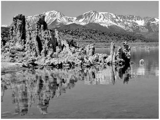
FIGURE 37. Mono Lake, showing calcium carbonate “tufa tower” formations that originally formed beneath the lake but are now exposed after the water level dropped. The eastern flank of the Sierra Nevada range is shown in the background. (Photo by D. J. DePaolo.)
This case profoundly affected California’s water policy, making it impossible for water administrators to neglect the needs of ecosystems in water policy decisions. The story of Mono Lake is considered a shining example of what is possible in environmental restoration of aquatic habitats, including rivers, lakes, deltas, estuaries, and marshes, that have suffered under water development.
The success at Mono Lake provides hope that perhaps other regions of the West decimated by water development will be revived in the future. For instance, biologists studying the Colorado River delta have noted that, after unusually wet winters such as the El Niño years of 1983, 1988, 1993, and 1997, winter rains and spring snowmelt filled the reservoirs on the Colorado River to the brim, forcing dam operators to release excess water. This relatively small amount of excess river water reached the delta and was sufficient enough to revive the habitat of a small region, perhaps 150,000 acres. Biologist Ed Glenn and his colleagues at the University of Arizona have speculated that these small releases mimic the spring floods that used to reach the delta before the dams were built. He proposes that 1 percent of Colorado River water be allocated for the delta every year in order to restore and maintain many of its key habitats.
Tulare Lake in California’s southern San Joaquin Basin is another candidate for restoration. Its inflowing rivers were diverted and the lakebed was converted to cotton fields, but, during very wet years, a small part of the lake basin floods. The nonprofit Tulare Basin Wildlife Partners has been preserving the one remaining creek that flows to the lake from the Sierra Nevada, and the group has begun small-scale restoration of wetlands around the lake.
DAM REMOVAL
Policymakers are analyzing other ways to reverse the collateral damage to our ecosystems from water development, including dam removal. In the arid West, colossal dams were once thought to be critical to prosperity. Today, there are alternatives that can achieve the functions provided by these dams, without the damage. Wetland restoration and riparian buffers can provide flood control. Limiting development in the floodplains can decrease risks from floods. Dam removal becomes a more reasonable proposal when we consider that dams have finite life spans, determined in part by the rate at which they fill with sediment. This has been known at least since the mid-1900s, when ecologist and environmentalist Aldo Leopold noted: “We build these dams to store water, and mortgage our irrigated valleys and our industries to pay for them, but every year they store a little less water and a little more mud. Reclamation, which should be for all time, thus becomes in part the source of a merely temporary prosperity” (p. 179).
This temporary prosperity comes at an enormous price. When the costs of a dam (environmental, cultural, or safety) outweigh the benefits (flood control, hydropower, water storage, and irrigation), we should consider removing it. Dam removal can be done successfully: in the United States, at least 600 dams have been removed since 1912; the majority of them were removed after 1980.
Along the Pacific Coast, dams are being proposed for removal in California, Oregon, and Washington in order to restore salmon spawning habitat. For instance, four dams on the Klamath River at the California-Oregon border are slated for removal to restore salmon habitat after Northern California Indian tribes filed lawsuits to restore their fishing rights. These tribes had relied on salmon from the Klamath for food as well as cultural and spiritual sustenance for millennia. After dam construction, salmon populations plummeted on a river that once supported the third largest salmon run in the West.
TOWARD A NEW POLICY OF BALANCE AND COOPERATION
The past century has pitted ecosystems in the West against an economic imperative of growth by an ambitious western society. Yet with each drought or flood, the costs mount—both to the ecosystems that are collapsing and to the economy that reels with each disaster. An alternative paradigm for the future would consider the relationship between sustainable water use and the delicate balance of life within an environment that has evolved over many millennia. Human society must find its place as part of the delicate balance, not apart from it. Achieving this balance will be both increasingly important and increasingly difficult in the future should the region’s climate, as predicted, become drier and punctuated by more floods. Now is the time for policymakers and residents to move toward a new, overarching policy of collaboration, to act together for the collective good and the survival of the region.
One example of collaboration can be found in Northern California’s San Francisco Bay delta, which is currently a focal point of battles between water users and a collapsing ecosystem. The delta, which provides water for 27 million Californians (mostly in the southern part of the state) and millions of acres of farmland in the arid San Joaquin Valley, is the hub of the state’s water system. Many of the lessons that are being learned the hard way in the delta should help other similar water conflicts throughout the West.
As discussed in chapter 12, water development over the past century—resulting in changes in total river inflows and timing, salinity, water temperature, suspended sediment loads, contaminants, and nutrient levels—has greatly affected aquatic ecosystems and native fish habitats in the San Francisco Bay and delta. These impacts include population losses resulting in several native fish species (such as chinook salmon and delta smelt) being listed as threatened and endangered. In recent years, efforts to protect endangered fish have restricted the timing and amount of water diverted from the delta for the San Joaquin Valley and Southern California cities, leading California’s legislature to enact the Delta Reform Act in 2009. This act mandates that water planning and policy going forward in California now include two “co-equal goals”: protecting and rehabilitating the delta ecosystem, and supplying reliable water to the state.
Two major reports on sustainable water and environmental management in the delta were published in 2012 and 2011 by the National Research Council (NRC) and the nonprofit Public Policy Institute of California (PPIC), respectively. According to the former, an important first step toward a more sustainable water future is acknowledging that water scarcity is now a way of life. This recognition would allow water policies addressing this scarcity to be drafted and implemented. In California, as in much of the West, most of the surface waters have been allocated or even over-allocated; there is not enough water to reliably meet all desired uses and needs. Water scarcity has increased over the past century with the growth of population and irrigated agriculture. As discussed in earlier chapters of this book, the natural climate in the West is highly variable, and the past century of relatively wet climate may shift back to a drier phase. In addition, predictions are that the West will be even drier in the future as the climate warms. Coupled with continued population growth, the region will most certainly experience more severe and long-term water scarcity.
The NRC report notes that water scarcity has only been addressed in the past during periods of drought, using water rationing as the main coping strategy. Going forward, it recommends a long-term sustainable policy that incorporates water scarcity into water planning and management, such as pricing water to reflect its long-term scarcity and improving water conservation, efficiency, and productivity. The California legislature set new water conservation standards in 2009, mandating a 20 percent decrease in water usage per person by the end of 2020 in the urban sector. There are numerous ways of achieving this goal, including more water-efficient appliances, drought-tolerant landscaping, water recycling, and rainwater harvesting. However, agricultural water usage accounts for 77 percent of water usage in the state, yet it has not been held to a similar standard of water reduction. Many water-efficiency approaches that are now available to agriculture were discussed in the NRC report, such as using a tiered pricing structure, adjusting the timing and amount of irrigation to maintain specific soil moisture requirements of crops, replacing irrigation systems with closed-conduit systems (particularly drip or trickle systems), and recycling excess irrigation water.
The PPIC has further insights in its report, which notes that water is both a public good, providing critical environmental services, and a commodity, with a market value, and ultimately must be managed in a way that fulfills both of these roles. A balance must be struck between environmental and human needs in the West, and both water scarcity and environmental costs should be reflected in its price. Increasing water rates, for instance, by using tiered rates that increase with greater water usage would lead to greater conservation and increased water efficiency by urban and agricultural consumers. Higher-priced water would also encourage a shift from wasteful, lower-value, water-intensive uses (including the growing of crops such as cotton, rice, and alfalfa) to higher-value agricultural, urban, and environmental uses. Another strategy suggested by the report is the enactment of a “public goods” charge for major water users to generate funding for water management, infrastructure improvement, and environmental protection and restoration.
In addition to conservation of water through pricing, the PPIC report considers water supply sources and proposes using many different sources of water as a key strategy. This “portfolio approach” includes nontraditional sources like recycled wastewater for urban use and recycled irrigation water for agricultural use. Another key strategy discussed in the report is massive water storage in underground aquifers, which could serve as a water bank for drought years, particularly during multiyear droughts when surface reservoirs shrink. Groundwater storage would also buffer future shifts in the water supply when winter floods, caused by the shift from snow to rain, become larger and more frequent: an increase in the amount of water stored underground would free up surface reservoirs for flood control. Underground storage might also be less costly and more environmentally friendly than building more surface reservoirs.
Peter Gleick and his colleagues at the Pacific Institute point out that the twentieth-century approach to water policy was in creating “new” water for human use by building water infrastructure—such as dams and aqueducts—for water storage and distribution. (For further discussion, see chapter 12 in this book.) They argue that it is time to create new water through conservation and improved water-efficiency measures. Moreover, improving the efficiency of water use can have additional benefits, including better water quality, healthier aquatic ecosystems, greater reliability of the water supply during droughts, decreased energy demands, reduced water infrastructure costs, and higher crop productivity. Gleick’s team also points out that reducing unproductive uses of water is another important strategy in coping with water scarcity. For instance, improved technology and water management can reduce the amount of water evaporated from impermeable urban surfaces and irrigated fields or blown off large sprinklers used by farms. The team predicts that improvements in water stewardship practices in the agricultural sector, including reducing unproductive water loss, will go a long way toward helping the state cope with extended droughts and long-term water scarcity in the future.
Water policy experts and climatologists have also begun working together to integrate water management, flood protection, and restoration of aquatic ecosystems. For instance, Michael Dettinger and his colleagues at the U.S. Geological Survey have shown that a small number of very large storms provide 30–50 percent of California’s annual water supply. (Atmospheric river storms and the devastating floods they produce are described in chapters 2, 4, and 10 above.) They point out that much of the water from these storms is lost to human and ecosystem use during flooding because managers are forced to release water from over-full reservoirs. The team advises that state resource planners coordinate water management with flood control efforts, allowing the restoration of some floodplains to their natural function. This approach would increase the capacity of reservoirs without hampering flood control.
Today, scientists have a much greater understanding of the causes and consequences of the West’s climate than at any time in the past. We have also gained a broader perspective on the natural climate fluctuations in the region over the past millennia. The long-term history of natural climate patterns described in the pages of this book reveals that extreme flood and drought events struck the West at regular intervals. In addition to the recurrence of these extreme events, a future warmer climate brought on by human activities will bring drier conditions, interspersed with floods, to the region. The time for the West to prepare for this drier and more extreme future climate is now, rather than waiting until we are in the midst of a crisis and attempting to respond.
Fortunately, many strategies and options are available to the region. A more sustainable water future in the West would include linking urban growth with water supply and availability. Reconciling human and environmental uses of water, integrating management of water supplies, water quality, and flood protection, and managing water more flexibly and responsibly lie at the core of a more sustainable future. Continued research efforts toward forecasting major flood-producing storms as well as wet and dry periods associated with El Niño and La Niña events and other ocean-atmosphere oscillations (such as the PDO) will help with prediction of these extreme events and implementation of warning systems in flood-prone regions such as California’s Central Valley and Sacramento delta.
Society as a whole needs to be educated about water’s vital importance, its scarcity, and what we can do to help. An important first step would include increasing awareness about both the direct and the indirect water usage in our daily lives—our water footprint. All current residents in the American West would also benefit from reflecting on the native cultures that came before us, that lived more in tune with their environment and understood by necessity the delicate balance between consumption and conservation. Today, our society would do well to learn about this balance if we want to survive and thrive in the future. We should be neither at the mercy of the natural world nor at odds with it. Today, we can choose to reimagine our place in the delicate web of life in the West—by using sophisticated engineering and technology to devise ingenious solutions and by seeing beyond our desire to consume to a future where the needs of a healthy environment are also met. We may find that we have all we need to preserve our quality of life as well as to protect and preserve the natural environment around us for generations to come.