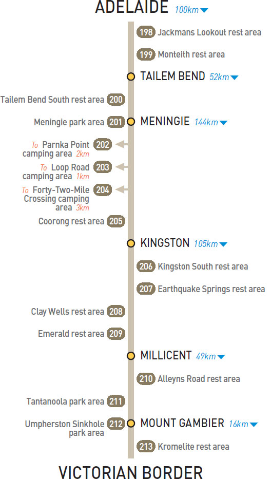
0.5km E of Swanport Bridge (L) or 19km W of Tailem Bend (R)
At the lookout overlooking the river.
| GPS: S35 08.667 E139 18.967 | MAP: D3, L10 |
4km E of Swanport Bridge (L) or 15km NW of Tailem Bend (R)
Just off the highway among a few trees.
| GPS: S35 09.460 E139 20.370 | MAP: D4, L10 |
6km S of Tailem Bend (R) or 46km N of Meningie (L)
Just off the highway among trees.
| GPS: S35 18.250 E139 25.833 | MAP: D4, L10 |
At Meningie
Adjacent to the highway and on the shores of a lake.
| GPS: S35 41.167 E139 20.333 | MAP: D5, L11 |
T/O 23km S of Meningie (R) or 121km NW of Kingston (L)
Two camping areas located 2km (unsealed) south of the highway on the foreshore in Coorong National Park. Toilets at nearby ‘day use only’ area.
| GPS: S35 53.833 E139 25.083 | MAP: D6, L12 |
T/O 61km SE of Meningie (R) or 83km NW of Kingston (L)
Opposite a lake 1km (unsealed) off the highway in Coorong National Park.
| GPS: S36 08.267 E139 38.483 | MAP: E6 |
T/O 78km S of Meningie (R) or 66km N of Kingston (L)
At a clearing behind dunes 3km (unsealed) west of the highway in Coorong National Park.
| GPS: S36 17.250 E139 42.700 | MAP: E7 |
120km S of Meningie (R) or 24km N of Kingston (L)
Just off the highway among shady trees.
| GPS: S36 37.250 E139 52.600 | MAP: E8 |
11km E of Kingston (L) or 94km N of Millicent (R)
Just off the highway among trees.
| GPS: S36 51.017 E139 58.350 | MAP: E9 |
51km S of Kingston (L) or 54km N of Millicent (R)
Just off the highway among shady trees.
| GPS: S37 10.418 E140 06.751 | MAP: E10 |
77km S of Kingston (R) or 28km N of Millicent (L)
Adjacent to the highway among a few trees.
| GPS: S37 23.600 E140 14.250 | MAP: F10 |
103km SE of Kingston (R) or 2km N of Millicent (L)
Adjacent to the highway among a few trees.
| GPS: S37 33.872 E140 21.304 | MAP: F11 |
5km SE of Millicent (L) or 44km NW of Mt Gambier (R)
Just off the highway among a few trees.
| GPS: S37 38.145 E140 23.535 | MAP: F11 |
At Tantanoola
Opposite the hotel.
| GPS: S37 41.800 E140 27.350 | MAP: F11 |
At Mt Gambier
Adjacent to the highway. On the east side of town.
| GPS: S37 50.274 E140 48.571 | MAP: G12 |
14km E of Mt Gambier (L) or 2km W of Victoria border (R)
Just off the highway among a few trees.
| GPS: S37 50.774 E140 55.273 | MAP: G12 |