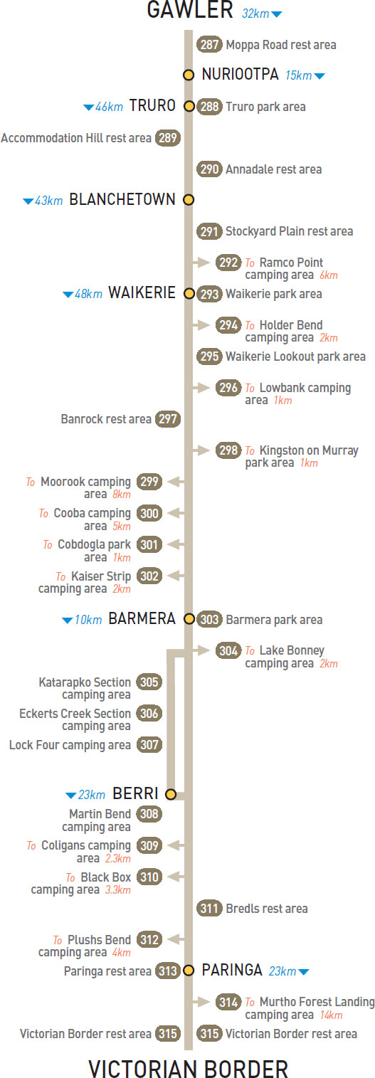
29km NE of Gawler (L) or 3km W of Nuriootpa (R)
Just off the highway behind a few trees.
| GPS: S34 27.550 E138 58.433 | MAP: C1, K8 |
At Truro
Adjacent to the highway. In the middle of town.
| GPS: S34 24.524 E139 07.710 | MAP: C1, K7 |
38km W of Blanchetown (L)
Just off the highway. For westbound only.
| GPS: S34 24.100 E139 12.827 | MAP: D1, K7 |
29km E of Truro (L) or 17km W of Blanchetown (R)
Just off the highway among trees.
| GPS: S34 23.367 E139 25.917 | MAP: D1, L7 |
23km NE of Blanchetown (L)
Just off the highway among a few trees. For eastbound only.
| GPS: S34 15.850 E139 48.533 | MAP: E1, M7 |
T/O at Waikerie
On a riverbank 6km west of Waikerie via Ramco and Ramco Point rds.
| GPS: S34 09.896 E139 55.836 | MAP: E1, M7 |
At Waikerie
On a riverbank via Peake Tce.
| GPS: S34 10.590 E139 59.032 | MAP: F1, M7 |
T/O 3km E of Waikerie (L) or 45km W of Barmera (R)
On the banks of a river 2km north of the highway via Holder Top and Holder Bottom rds.
| GPS: S34 11.141 E140 00.748 | MAP: F1, M7 |
2km E of Waikerie (L) or 46km W of Barmera (R)
Just off the highway with good views over a river.
| GPS: S34 11.233 E140 00.717 | MAP: F1, M7 |
T/O 7km E of Waikerie (L) or 41km W of Barmera (R)
On a riverbank 1km (unsealed) north of the highway via Lowbank Rd.
| GPS: S34 11.050 E140 04.331 | MAP: F1, M7 |
28km E of Waikerie (R) or 20km W of Barmera (L)
Just off the highway among a few trees.
| GPS: S34 11.600 E140 17.150 | MAP: F1, N7 |
At Kingston on Murray
Overlooking the river in the middle of town.
| GPS: S34 13.273 E140 20.815 | MAP: F1, N7 |
At Moorook
Overlooking a river in the middle of town.
| GPS: S34 17.300 E140 22.083 | MAP: F1, N7 |
T/O to Moorook
Large campground located 5km (partly unsealed) south-east of the highway on a riverbank in Moorook Game Reserve.
| GPS: S34 16.017 E140 22.183 | MAP: F1, N7 |
At Cobdogla
At Bruno Bay boat ramp on the west side of town.
| GPS: S34 14.491 E140 23.838 | MAP: F1, N7 |
T/O at Cobdogla
Several small camping sites just off the highway among trees on riverbanks in Loch Luna Game Reserve.
| GPS: S34 14.033 E140 23.300 | MAP: F1, N7 |
At Barmera
Overlooking Lake Bonney.
| GPS: S34 14.967 E140 27.583 | MAP: G1, N7 |
T/O at Barmera
Among trees on the shores of the lake in Lake Bonney Reserve. Just north of Barmera township via Queen Elizabeth Dr.
| GPS: S34 13.633 E140 28.200 | MAP: G1, N7 |
T/O to Berri
Numerous sites on the riverbanks in Murray River National Park. Located 5km west of Berri via Old Sturt Hwy then 10km south via Winkie Rd.
| GPS: S34 21.483 E140 31.433 | MAP: G1, N7 |
T/O to Berri
Numerous sites along the river in Murray River National Park. Located 3km west of Berri via Old Sturt Hwy then 9km south via Lower Winkie Rd (partly unsealed) and Migga Rd (unsealed).
| GPS: S34 18.959 E140 32.540 | MAP: G1, N7 |
T/O to Berri
Numerous sites along the river in Murray River National Park. Located 5km south-west of Berri via Draper Rd (partly unsealed).
| GPS: S34 19.056 E140 34.256 | MAP: G1, N7 |
T/O to Berri
Located 3km east of Berri via Riverview Dr among numerous large trees on the banks of the Murray River.
| GPS: S34 17.429 E140 37.813 | MAP: G1, N7 |
T/O 10km NE of Monash (R) or 12km SW of Renmark (L)
Large area among trees on a riverbank in Murray River National Park. Located 2.3km (partly unsealed) south-east of the highway.
| GPS: S34 14.959 E140 39.158 | MAP: G1, N7 |
T/O 10km NE of Monash (R) or 12km SW of Renmark (L)
Large area among trees on a riverbank in Murray River National Park. Located 3.3km (partly unsealed) south-east of the highway.
| GPS: S34 14.640 E140 39.720 | MAP: G1, N7 |
14km NE of Berri (L) or 6km SW of Renmark (R)
Small area adjacent to the highway.
| GPS: S34 12.391 E140 42.136 | MAP: G1, O7 |
T/O 19km NE of Monash (R) or 3km SW of Renmark (L)
Among trees on a riverbank 4km (partly unsealed) southeast of the highway via 23rd St.
| GPS: S34 12.995 E140 45.264 | MAP: G1, O7 |
At Paringa
On the banks of a river near the bridge at Bert Dix Park. Overnight parking for self-contained vehicles only.
| GPS: S34 10.989 E140 46.600 | MAP: G1, O7 |
T/O at Paringa
Shady site on a riverbank 14km north-east of Paringa via Murtho Rd and Heading Rd (unsealed).
| GPS: S34 03.936 E140 46.855 | MAP: O7 |
18km E of Paringa (L) or 1km W of Victorian border (L)
Well off the highway among a few trees. On both sides of the highway.
| GPS: S34 16.137 E140 54.278 | MAP: H1, O7 |
Traveller’s Tip
BE AWARE OF agricultural checkpoint locations so that you don’t stock up with fruit and vegetables that you have to surrender. Roadside fruit and vegetable stalls in agricultural areas offer good produce at economical prices.