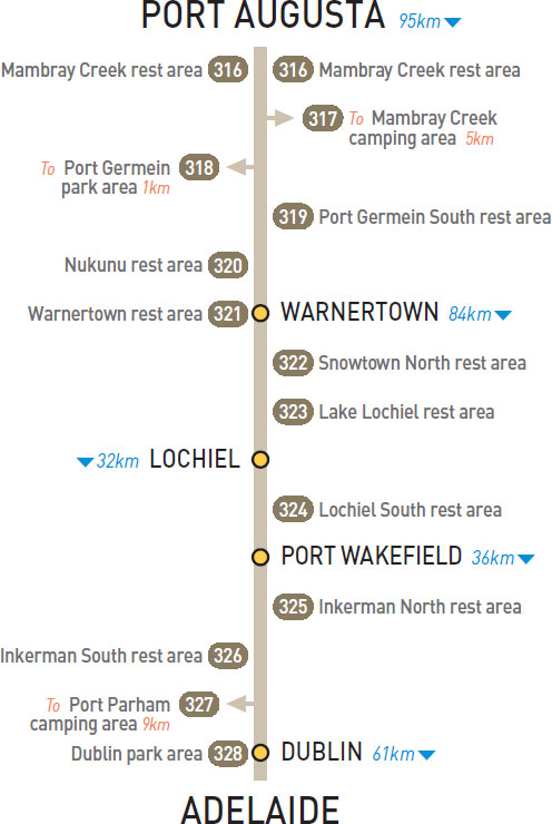
T/O 48km S of Port Augusta (L) or 47km N of Warnertown (L)
Under trees on both sides of the highway.
| GPS: S32 50.765 E137 58.937 | MAP: I3, G10 |
T/O 48km S of Port Augusta (L) or 47km N of Warnertown (R)
At the base of some ranges 5km east of the highway in Mt Remarkable National Park.
| GPS: S32 50.433 E138 02.233 | MAP: I3, H10 |
At Port Germein
On the foreshore 1km south-west of the highway via The Esplanade.
| GPS: S33 01.345 E137 59.918 | MAP: I3, G11 |
72km S of Port Augusta (L)
Secluded behind trees. For southbound only.
| GPS: S33 02.738 E138 01.822 | MAP: I3, H11 |
23km N of Warnertown (L)
Well off the highway with good views of the coast. For northbound only.
| GPS: S33 02.738 E138 01.822 | MAP: I3, H11 |
At Warnertown
Just off the highway. On the south side of town. For northbound only.
| GPS: S33 14.276 E138 07.247 | MAP: I4, H11 |
62km S of Warnertown (L)
Under trees just off the highway. For southbound only.
| GPS: S33 44.870 E138 12.577 | MAP: I5 |
82km S of Warnertown (L) or 33km N of Port Wakefield (R)
Just off the highway and overlooking the lake.
| GPS: S33 54.807 E138 09.791 | MAP: I6 |
3km S of Lochiel (L)
Adjacent to the highway under a few trrees. For southbound only.
| GPS: S33 57.485 E138 10.578 | MAP: I6 |
12km S of Port Wakefield (L)
Just off the highway. For southbound only.
| GPS: S34 15.327 E138 13.381 | MAP: A1, I7 |
22km N of Dublin (L)
Just off the highway. For northbound only .
| GPS: S34 17.396 E138 14.543 | MAP: A1, I7 |
At Port Parham
On the esplanade 9km west of the highway.
| GPS: S34 25.589 E138 15.382 | MAP: A1, I7 |
At Dublin
On the service road.
| GPS: S34 27.119 E138 21.109 | MAP: B1, J8 |
Traveller’s Tip
GARLIC IS GOOD to take for the prevention of sandfly bites. Always have some Stop Itch and antiseptic cream in your first-aid kit, which should be checked and replenished regularly.