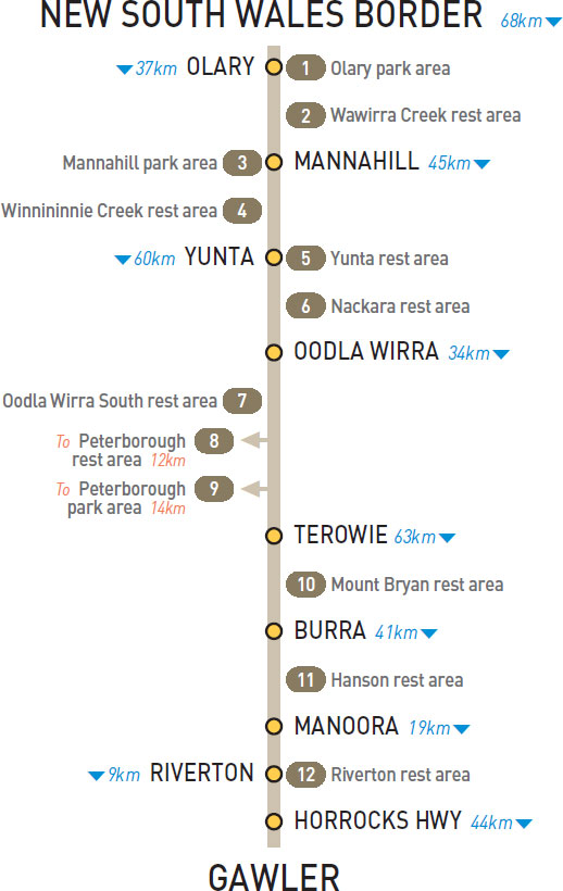
At Olary
Adjacent to the highway and opposite the hotel.
| GPS: S32 16.904 E140 19.577 | MAP: N1, M9 |
26km W of Olary (L) or 11km E of Mannahill (R)
Just off the highway among some trees on the east side of the creek.
| GPS: S32 23.892 E140 05.614 | MAP: M2, L9 |
At Mannahill
Adjacent to the highway and next to the hotel.
| GPS: S32 25.860 E139 59.210 | MAP: M2, L9 |
36km SW of Mannahill (R) or 9km NE of Yunta (L)
Just off the highway among a few trees.
| GPS: S32 32.644 E139 39.349 | MAP: M2, K10 |
At Yunta
Adjacent to the highway and opposite the hotel.
| GPS: S32 34.908 E139 33.749 | MAP: L2, K10 |
27km NE of Oodla Wirra (L)
Well off the highway among a few trees. For eastbound only.
| GPS: S32 46.000 E139 17.227 | MAP: L3, J10 |
3km S of Oodla Wirra (R) or 31km N of Terowie (L)
Just off the highway among trees.
| GPS: S32 53.957 E139 02.663 | MAP: K3, J10 |
T/O to Peterborough
Under a few large trees 2km east of Peterborough.
| GPS: S32 58.168 E138 51.779 | MAP: K3, I11 |
At Peterborough
On the west side of town via Main St.
| GPS: S32 58.436 E138 49.848 | MAP: K3, I11 |
At Mt Bryan
Adjacent to the highway and opposite the hotel.
| GPS: S33 33.007 E138 53.532 | MAP: K5, I12 |
13km S of Burra (L) or 28km N of Manoora (R)
Just off the highway among a stand of pine trees.
| GPS: S33 45.158 E138 50.405 | MAP: K6 |
At Riverton
Just off the highway among trees. On the south side of town.
| GPS: S34 10.287 E138 44.769 | MAP: C1, J7 |