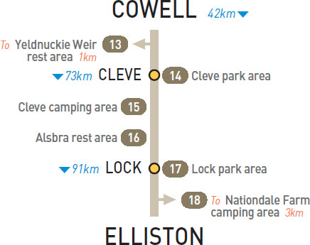
T/O 37km W of Cowell (R) or 5km E of Cleve (L)
Below the dam wall, 1km (unsealed) north of the highway.
| GPS: S33 41.569 E136 32.635 | MAP: F5 |
At Cleve
Opposite the showgrounds in the main street. On the west side of town.
| GPS: S33 42.109 E136 29.410 | MAP: F5 |
At Cleve
Basic caravan park facilities at the showgrounds in the main street. On the west side of town.
| GPS: S33 42.087 E136 29.437 | MAP: F5 |
73km E of Cleve (L) or 40km W of Lock (R)
Just off the highway among a few trees.
| GPS: S33 40.061 E136 09.103 | MAP: E5 |
At Lock
At the junction of the Birdseye and Tod hwys.
| GPS: S33 34.184 E135 45.428 | MAP: D5, C12 |
T/O 7km E of Elliston (R) or 84km W of Lock (L)
In scrub 3km (unsealed) south of the highway. Follow the yellow paint markers past the farmhouse to the camping area. Donations accepted. Phone Darren (0408 916 216) for assistance or enquiries.
| GPS: S33 38.396 E134 57.630 | MAP: B5 |
Traveller’s Tip
SUN PROTECTION IS essential. Have a small bottle of sunblock in a handy place in the car or cut the sleeve off a large shirt and carry it in the pocket of the door. When the sun hits your arm, slide it on.