
Plan your walk |
|
 |
DISTANCE: 3 miles (4.8km) TIME: 1½ hours START/END: SD170977 Roadside parking on the minor road opposite the track for Devoke Water TERRAIN: Moderate; wet MAPS: |
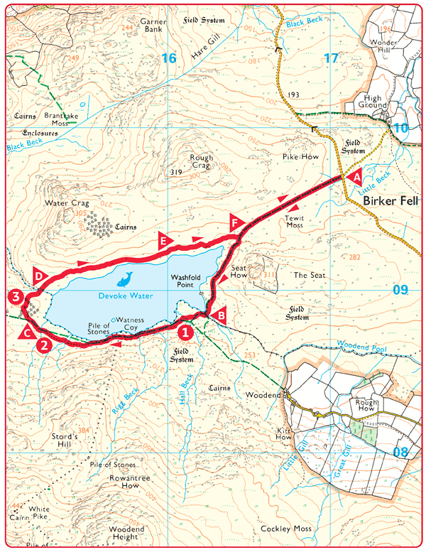
 Park your car by the roadside by the minor road opposite the track for Devoke Water. The walk starts here and you follow the track across to the edge of Devoke Water.
 Continue on the track which bears left around the tarn. Continue straight on, following a smaller path around the tarn, when the track goes right to a boat house at Washfold Point.
 Viewpoint across the tarn to Water Crag and Rough Crag on the north side.
 Viewpoint with the Scafell range, Bowfell, and Langdale fells in background.
 As the path passes the western end of the tarn, cut off to the right, continuing around the tarn.
 At a cairn on slightly higher ground, there is a viewpoint west towards the sea and east over the lake and the fells above Eskdale and Dunnerdale.
 Cross the tarn outlet with care. The route beyond is fairly pathless. Head for higher ground on the lower slopes of Water Crag as you continue around the tarn.
 The boggy areas here are not usually too soft.
 Complete the circuit of the tarn by rejoining the outward track, and retrace your steps back to the starting point.

Archaeological evidence, and examination of pollen types found deep in the mud and peat, has shown that in prehistoric times the landscape around Devoke Water was forest, and that there was very extensive human settlement by Neolithic farmers or hunters. There are also many burial mounds and hut circles in the district. Since then, climatic change, and the hand of man has reduced the area to wild open moorland.
