
Plan your walk |
|
 |
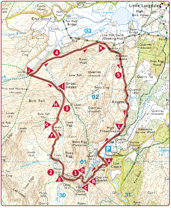
DISTANCE: 4 miles (6.4km) TIME: 2½ hours START/END: NY305010 Old quarry parking area at the foot of Tilberthwaite Gill, which is reached by a minor road off the Coniston to Ambleside road TERRAIN: Moderate; some very steep, rough, wet sections MAPS: |
 Park in the old quarry parking area at the foot of Tilberthwaite Gill, which is reached by a minor road off the Coniston to Ambleside road. From Coniston it is the first turning to the north. From Ambleside it is the second turning on the right after passing the little roadside tarn (Yew Tree Tarn). Climb the steps from the car park and follow the path on the left hand side of Tilberthwaite Gill, following the Gill’s course at a higher level.
 At path junction by small ruin, bear right, initially on the level, and then continue on path as it drops down to the footbridge across the Gill.
 Viewpoint. The fall here is not great but the volume of water is often very considerable. The upper falls cannot be reached. Earlier last century more bridges and catwalks were in position above this viewpoint bridge but they have been swept away by major floods which have torn down the unstable walls of the ravine.
 Cross the footbridge and follow the steps and footpath steeply upwards.
 The path crosses a fence at a kissing gate and joins the old miners’ track. Go left up the path, which runs very close to the ravine with the water cascading down below. Take care as there is a very steep drop on the left.

 At the top of the Gill ravine, bear right, continuing on the old miners’ track.
 Everywhere there are signs of copper mine workings. There is some evidence that copper was mined here in Roman times, though inevitably many of the signs of old workings have been destroyed by more recent activity. The last major efforts in this area, including the driving of a 3000ft level (914m), and the sinking of a 390ft shaft (120m), occurred in 1850, but extraction proved too costly and the main production became concentrated in the Coniston Copper Mines to the south-west, and at Greenburn to the north.
 At this point, which is near more old mine workings and marked with a cairn, and where the main track bears left to ascend towards Wetherlam, go right and upwards on a faint path. Shortly afterwards the path takes you round a fence which is guarding a collapsed and dangerous mineshaft.
 At the top of this saddle, follow a fairly indistinct path which descends to another saddle where you join a fence. At this point you have the option of ascending the small hill to the right (marked with the 428m spot height) which is a great viewpoint.
 Just after the fence junction and before the bend, cross the fence by a stile and take the faint path which angles down to the wall. Turn left and follow the wall down to a step stile. Cross the stile on to the north side of the wall.
 There are many fine views of Langdale Pikes but surely none to cap this! In the foreground there is a tumble of crags and between Blake Rigg and Lingmoor, Blea Tarn can be seen.
It is surely one of the best mountain prospects in Britain.
 Follow the indistinct path on the north side of the wall.
 Join the miners’ track and go right.
 Enjoy further marvellous views over to Langdale Pikes. Here the foreground is a rocky chaos, a turmoil of craggy shapes, adding more drama. Forward is Little Langdale Tarn. The road over Wrynose begins below in Little Langdale. The modern road follows the old Roman road (the ‘Xth iter’) over the pass, linking the forts at Ambleside and Hardknott and on to Ravenglass. Its route is not traceable until it reaches the farm of Fell Foot below, but from there onwards it is to the north, the far side, of the present road.
 At the track junction, turn right onto the larger track. After 100m, bear right at a fork, signposted Tilberthwaite. Continue on this larger track, ignoring any detours which lead into old quarries.
 Extensive quarrying to the right. The quarrying boom followed the copper mining. A detour to look at the slate might be of interest. The colour varies in each locality. The material was formed from volcanic dust laid down under water and the ripple marks can sometimes be seen. The slate is hard and takes a good polish. In the boom in the 19th century records show that a quarryman was paid a guinea (£1.05) for working a six day week.
 At the end of the track, go through a farm, closing the gates behind you, and continue on the surfaced lane to the starting point.