
Plan your walk |
|
 |
DISTANCE: 4½ miles (7.2km) TIME: 2¼ hours START/END:NY317195 Legburthwaite car park ¼ mile north of Stanah, Thirlmere on the St John’s (Threlkeld) road TERRAIN: Strenuous MAPS: |
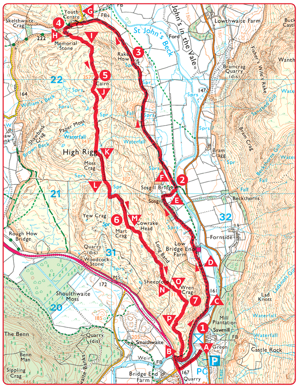
 Start at the Legburthwaite car park and picnic area 550yds (500m) north of Stanah, Thirlmere on the B5322 St John’s in the Vale (Threlkeld) road. Walk out of the car park towards the picnic area, but turn left onto the old road which takes you up to the main Keswick road. Turn right along the verge and, immediately after crossing the bridge, turn right over the stile onto the footpath.
 Shortly afterwards ignore a faint path to the right and a little further keep straight on at a junction on a narrow but good path parallel with the river.
 This is a delightful path on a wooded terrace with a good view of the river.
 The path nears the river by some large boulders, then bears away from it to follow a wall to the left.
 After a stile and a gate, climb left to follow the path above the farm buildings and tearoom.
 Continue on this path, with the wall on your right, until you reach the ruined building at Sosgill. Divert right at this point and walk across to the bridge.
 Sosgill Bridge, a stone arched bridge with a fine view of Blencathra (Saddleback).
 From the bridge, follow the faint path across the field to the gate, and turn right and rejoin the main path.

 Rake How, a ruined farm.
 Join the tarmac road and turn left.
 St John’s Church. The isolated situation may seem odd, but the road here was once well used. The first written reference to the church was in 1554, but the site predates that as it was built on the site of an earlier church. The existing building dates from 1845. The atmosphere inside is homely and friendly. Nearby is buried St John’s best known personality, John Richardson (1817–1866) the talented dialect poet who helped to build the church.
 Go on past the church and then immediately after the youth centre turn left onto a path. Follow it uphill and through a kissing gate.
 Continue upwards on a grassy path to the ridge.
 Summit cairn. Spectacular views over to Blencathra (Saddleback) (2847ft/867.7m) to the right; Skiddaw (3054ft/930.8m) to the left and to the far left Grisedale Pike, Causey Pike and Bassenthwaite Lake.
 From the cairn follow the path which goes downhill and across to a wall corner. This is open fell and you can make detours to take in the views.
 The path continues to the right of the wall and reaches a boggy area. The worst of this can be avoided by taking a sweep to the right and returning leftwards under the face of a small crag.
 Follow the wall down and over a stile, then bear left up a small path to regain the ridge.
 Pass a small tarn and follow a fence for a further 220yds (200m), then turn left over a stile and follow this path along the ridge.
 Views. Helvellyn is ahead. The 3113ft (948.8m) summit is almost obscured by Whiteside and Low Man. Thirlmere is seen between the impressive wooded jaws of Great How and Raven Crag.
 To get off the ridge with as little difficulty as possible, aim for a gap in the wall ahead, bearing left off the ridge to follow the path down and through the gap.
 Follow the path ahead onto the summit of Wren Crag, just above the pine trees.
 Exciting views here framed in some beautifully sculpted Scots Pines.
 Descend steeply on the path through the woods, and rejoin the outward route at
  . Turn right at the path junction, go over the stile and retrace your steps back to the car park.