THE HIGHLAND INTERIOR
Inland from the relatively fertile coastline, Iceland’s Highland Interior is a beautiful wilderness of black gravel, lava plains and glaciated peaks, blasted by summer storms and winter frosts. Not surprisingly, the Interior is un-inhabited, but the ghosts of numerous pack-horse trails have now been graded for 4WDs only. Open for a few weeks in summer, the most accessible of these routes are the Kjölur (from Gullfoss to near Akureyri) and Fjallabak (from Hella to Kirkjubæjarklaustur). Long-distance buses follow these routes from June to September. At the moment, there are also tourist flights over the ongoing eruption of Bárðabunga at Holuhraun.

1. Veiðivötn and Langisjór
Veiðivötn and Langisjór are part of a complex of inland waterways inside volcanic “stretch marks” southwest of Vatnajökull, reached off the F208 Fjallabak Route. There are good fishing areas amidst the stark countryside. Veiðivötn is an area of tarns and streams, while Langisjór is a narrow stretch of water. Both are accessible only along rough tracks and there is no public transport.

2. Hveravellir
Halfway along the Kjölur Route, Hveravellir is a desolate hot springs area with an outdoor hot tub, calcified mounds bubbling boiling water, a strong smell of sulphur and a basic hut with bunk beds run by the Icelandic Touring Association (www.fi.is). The 17th-century outlaw Eyvindur spent many winters here until local farmers chased him out.
3. Mount Hekla
East of Þjórsá river is Mount Hekla, which means “hooded”, after the clouds that obscure its summit. It was once believed to be the entrance to hell, due to its eruptions followed by months of noisy “grumbling” (taken to be the sound of tormented souls). On a good day, you can see the mountain from Hella on Route 1, and you will pass close to it en route to Landmannalaugar. Many companies run 4WD circuits and trips to the mountain in summer.

4. The Kjölur Route
 Bus schedule: www.bsi.is • Road open mid-Jun–late Aug
The Kjölur Route (Kjalvegur) is the least difficult of the Highland roads to traverse, running for 170 km (106 miles) from Gullfoss to Route 1 near Blönduós. All the major rivers have been bridged and the gravel track is safe for cars. Sights along the way include Hveravellir’s hot springs and the Langjökull icecap.
5. Landmannalaugar
Relatively accessible and just 3 or 4 hours’ drive from Reykjavík, Landmannalaugar delivers a full-on Highland experience. The road takes in volcanic wastelands, exciting river crossings, mountains and hot springs. There are enough hills, lava fields and lakes to spend a day exploring. You could even stay at the bunkhouse or the campsite and spend 4 days hiking to Þórsmörk along the Laugavegur trail (see Laugavegur).

6. Þórsmörk Reserve
Iceland’s most popular hiking area (see Þórsmörk), accessible only by 4WD from the highway near Hvolsvöllur via the 30-km- (19-mile-) long F249 – watch out for the potentially dangerous river crossing at the end – or by trekking in along Laugavegur or from Skógar via Fimmvörðuháls. Set in an exceptionally pretty glacial valley, the pick of the views at Þórsmörk are from Valahnúkur (an easy and short ascent) and Utigönguhöfði (an arduous and long ascent). There are plenty of self-catering cabins and campsites, and daily buses in summer.
7. Lakagígar
 Buses: Jun–Aug daily • Bus schedule: www.bsi.is
This 25-km- (16-mile-) long row of craters erupted with a vengeance in 1783, disrupting weather patterns all across Europe and nearly depopulating Iceland (see Lakagígar). Walking trails ranging in length between 20 minutes and 2 hours allow you to explore the line of cones and expansive lava fields, which are now partly buried under a thick matting of moss and heather. There is no accommodation on site, but mountain huts and campsites can be found along the road. Seasonal buses from Skaftafell run here via Kirkjubæjarklaustur and the 60-km- (37-mile-) long F206.
8. Langjökull
 Year-round Jeep tours from Reykjavík • www.adventures.is
Iceland’s second largest icecap, the “Long Glacier” west of the Kjölur Route, feeds Hvítárvatn and Sandvatn lakes, which in turn drain into the Hvítá river, on which the spectacular Gullfoss waterfalls are located (see Gullfoss). There is talk of damming another of Langjökull’s lakes, Hagavatn, for hydropower. Apart from seeing the glacier from the Kjölur or Kaldidalur routes, tours run up here for snowmobiling trips – you only get an hour but it is an exhilarating experience, like riding a Jet Ski on snow.

9. Aldeyjarfoss
 Bus schedule: www.re.is
Although this impressive waterfall on the Skjálfandafljót river sits at the northern end of the otherwise difficult Sprengisandur Route, it is actually located on a good gravel road 30 km (19 miles) south of the Goðafoss waterfall (see Goðafoss). Most vehicles can make it with care during the summer, but check conditions first. The surrounding rock formations are what make Aldeyjarfoss so striking. A layer of outlandishly fashioned basalt columns is capped by a thick blanket of solidified lava. Buses negotiating the Sprengisandur crossing between Reykjavík and Akureyri make it a point to stop here.

10. Herðubreið
Widely known as the “Queen of the Icelandic Mountains”, Herðubreið’s spiky palagonite heights rise to an impressive 1,682 m (5,518 ft) northeast of Askja, above the dismal Ódáðahraun (“Desert of Evil Deeds”). The slopes are laced with short freshwater springs and covered with the pink blooms of the Arctic river beauty flower in July. You get good views of the mountain on a clear day from the road to Kárahnjúkar in Eyjabakkar, but if you fancy hiking, stop on the F88 between Mývatn and Askja (see Lake Mývatn Area).
HIGHLAND DRIVING
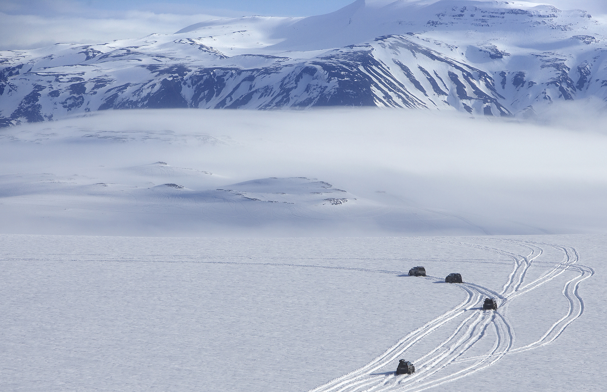
Rough conditions, no settlements and nobody to help if something goes wrong all make it imperative that Highland roads are tackled only in high-clearance 4WD vehicles. Travel in convoy, check road conditions before setting out (www.vegagerdin.is) and give your route and estimated arrival time to someone reliable so rescue can be organized if needed.
A DAY IN THE HIGHLANDS

Morning
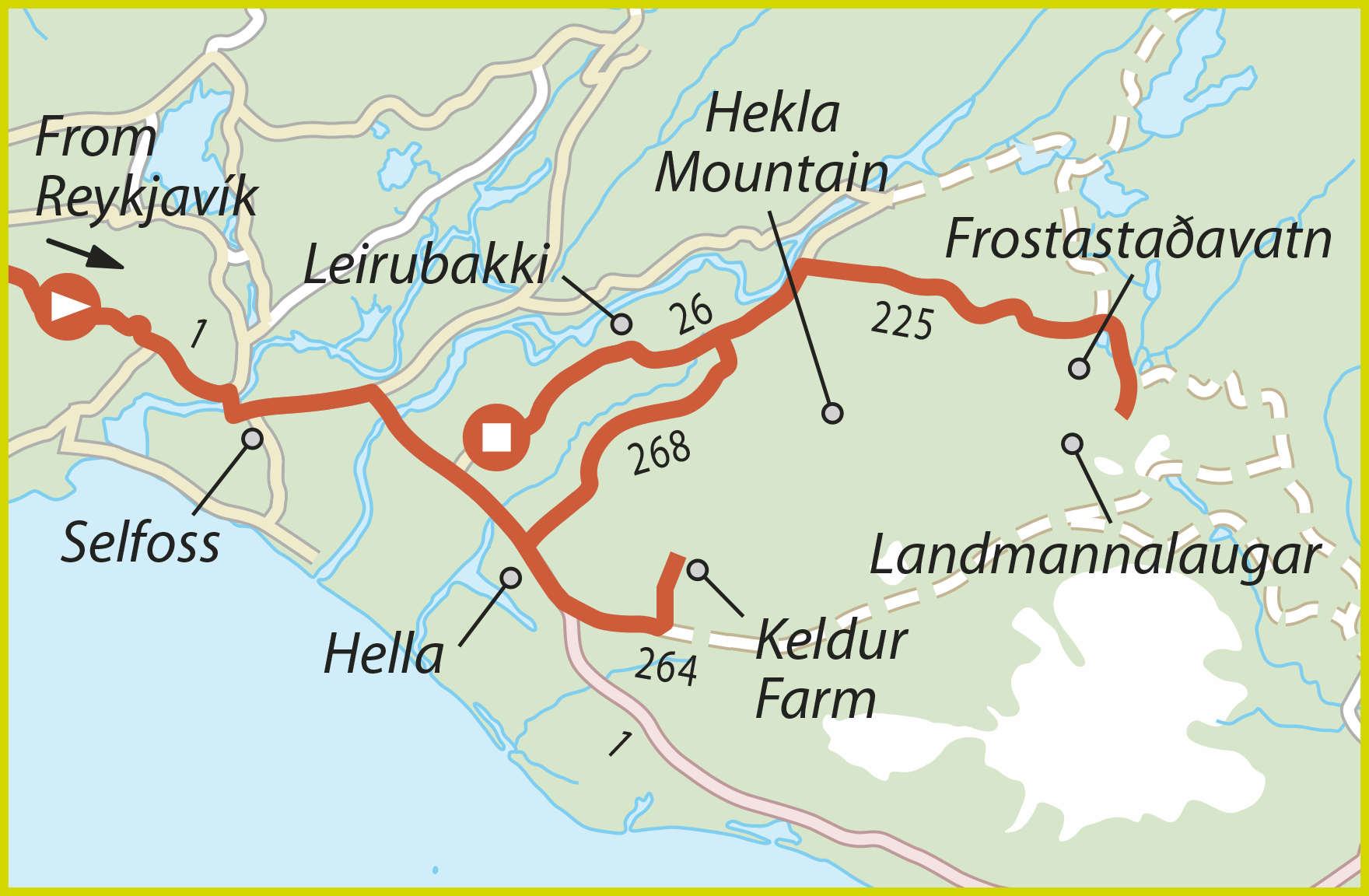
Start early for this day trip to Landmannalaugar and bring a packed lunch. The journey will take upwards of 8 hours, depending on how many times you stop along the way. Head east along Route 1 from Reykjavík via Selfoss and Hella, then turn north up Route 264 to see the Viking buildings at Keldur Farm. With Hekla looming behind, take a moment to appreciate Keldur’s location – so close to an active volcano. Retrace the route towards Hella, then turn north along Route 268 for a half-hour run through lava fields to Hekla and the intersection with Route 26. You could turn left here to Leirubakki, but for Landmannalaugar turn right, driving across the yellow pumice plain between Hekla and the Þjórsá river, before reaching the junction with F225, which heads east to Landmannalaugar. Pull up and enjoy your picnic lunch.
Afternoon
The F225 road traverses the black-sand wasteland of Hekla’s northern foothills, with several river crossings before it reaches an intersection after 47 km (29 miles). Turn right (south) at this junction, which leads down to Frostastaðavatn’s lakeshore and then right again onto the 5-km- (3-mile-) long F224, which crosses a double fjord before reaching Landmannalaugar. Soak in the spring and then prepare to head back. Once you are on Route 26, simply follow it south to back to Route 1 between the towns of Hella and Selfoss.


