Chapter 20: San Marcos River

Huge volume of spring water on the upper reaches keeps this river fishing well year-round; look for Rios in wintertime, massive sunfish, and a melting pot of bass. Access points: 6.
The San Marcos River was first described by early Spanish explorers in the 1690s, and at various times it went by the name San Agustin and Los Inocentes (possibly for the friendly Tonkawa Indians early visitors found living there). By 1716, the stream’s current name was firmly established.
The river rises in the heart of San Marcos, from the San Marcos Springs. The cluster of three major artesian fissures and more than two hundred smaller springs together pump an average of 200 million gallons of 72-degree water each day to form Spring Lake and headwaters of the river. The Tonkawa, who farmed in the area from as early as 1300 A.D., called the springs Canocanayesatetlo, or “warm water.” Ongoing archeological investigations suggest that the springs may be the oldest, continuously inhabited location in the present United States, with evidence of Clovis culture inhabitants dating back 12,000 years.
Early visitors reported abundant wildlife, including bears, mountain lions, and alligators. Glass-bottom boats were introduced to the springs in 1921, and you can still take a ride in one today by visiting the Meadows Center for Water and the Environment (29.89413, -97.92966), a research center at Texas State University that occupies the former Aquarena Springs resort complex.
The San Marcos River flows 75 miles in a southeasterly direction to its confluence with the Guadalupe River 2 miles west of Gonzales.
There is ample access to the river in San Marcos proper, where it is a popular recreational stream (think inner tubes and kayaks). You can try City Park (29.88603, -97.93512) or Rio Vista Park (29.87845, -97.93393), just to name two possibilities.

An anchor system is helpful when fishing the San Marcos. Paddlers also can beach their boats on gravel bars and wade fish in some locations.
For anglers, kayaks, canoes, and rafts are the primary means of accessing the river, as much of the stream is not suitable for wading. The Texas Water Safari, “the world’s toughest canoe race,” begins at the headwaters of the San Marcos River, and competitors have one hundred hours to paddle 260 miles to Seadrift on the Gulf Coast. The race is held the second Saturday of June every year.
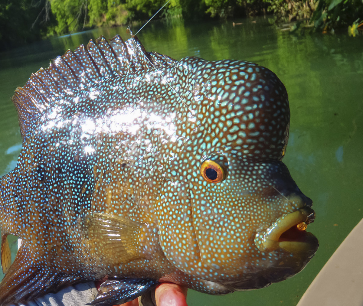
The San Marcos River is one Central Texas Stream where anglers can catch Rios year round.
Mostly due to that race, the San Marcos is well-mapped, and an enterprising angler with rudimentary internet sleuthing skills can find detailed accounts of pretty much the entire river, including the location of the numerous snags and strainers, portages, and access points.
To give you a taste, we’ll look at one potential wade and a paddle.
|
FM 1979, Martindale |
|
|
29.83240, -97.84235 |
|
|
203 FM 1979, Martindale, TX 78655 |
|
|
36.2 road miles, 0:43 drive time |
|
|
Difficulty: Moderate |
|

Most people who know the San Marcos think of the tubing and kayaking opportunities near Texas State University, in the town of San Marcos. Or maybe, like me, they were lucky enough to make their Open Water certification dives in Spring Lake. Most fly fishers dream of downstream reaches, centered on the Martindale area. The Farm Road 1979 bridge offers a rare opportunity to wade the river.
What You Will Find
Walk down to the water along the guardrail on the north side of the road. As with the entire mineral-rich San Marcos, water here is not murky, exactly, but neither is it gin clear like the headwaters springs or some of the more northerly streams in these pages; rather, when it is healthy and flowing well, it will be a deep, emerald green
 The Martindale Dam Wade (Fishing Upstream from the Bridge)
You’ll begin this wade in thigh- to waist-deep water river left (your right—the bank from which you entered). The bottom is mostly tightly packed gravel, but you will encounter areas of silt deposition in some places.
At a little more than 400 feet above the bridge, you’ll come to the first bend in the river. The gravel bars here are rearranged with every flood. There are boulders in the water river right, just across from the bend, and they provide excellent ambush points for bass. In this reach of the San Marcos, you may encounter largemouth bass, smallmouth bass, Guadalupe bass, or spotted bass; more than likely, any fish you catch will be a largemouth or some mix of the latter three species (see the Know Your Central Texas Bass chapter).
Around the bend, and for the next 500 feet or so, the stream is shallower and rocky, more good habitat for the riverine basses, which you will find in the seams of the current. This is also outstanding Rio and sunfish territory, and the sunnies in this reach of the river attain record sizes.
Continue upstream river left to a silty backwater and laydown on the same side at three-tenths of a mile above the bridge. This is a good place to look for carp or the more prevalent smallmouth buffalo. Just above this backwater, you will find a large gravel bar river left. The river bank here is part of the City of Martindale’s Allen Bates River Park (29.83717, -97.84265), free and open to the public during daylight hours. This also would be a fine place to start or end a wade on this section of the river.
Above the park, when you run out of gravel river left, cross the river in waist- to chest-deep water to the south (here it is west) bank to continue upstream. Standard practice on the San Marcos River, especially during the warmer months, is to “bang the banks” with poppers or deer hair bugs. It is particularly effective on segments like this one, with steep banks and heavy tree cover.

At about 0.5 miles above the bridge, you’ll see a gravel island in the center of the river—look for Rios here in the summer and bass chasing sunfish in the shallows, especially on the downstream side. A Rio Getter or Hatchling Craw will work on the Rios, and a Lunch Money or Brunch Money streamer (see A Central Texas Fly Box, page 45). will trick the bass. Above the small island, laydowns and a riffle provide more good habitat. Take your time wading through this section.
The next pool is wide and deep; keep river right (your left) and portage the one-lane, wooden bridge at just under 0.6 miles above the put-in, on the west side. Above the wooden bridge, another large pool is wadeable, in waist- to chest-deep water, river right. This pool ends at the Martindale Dam (portaged river right if paddling downstream). The highly oxygenated water pouring over the dam is terrific for huge sunfish; try drifting a lightly weighted damsel nymph in the current.

Sycamore and cypress trees put on some fall color to delight San Marcos River paddlers.
Getting There
From downtown, Take I-35 south to Exit 205 in San Marcos. Go left, under the interstate highway, on Texas Highway 80. Follow TX 80 5.9 miles to FM 1979 where you will go right and continue for 0.9 miles. As you approach the bridge over the San Marcos River, you’ll want to park off the road on the north side.

Spencer Canoe’s is a venerable center of Texas Water Safari activity only lightly used by recreational paddlers and anglers year-round. Pay the $5 per vehicle fee (plus $5 per paddler) at the office or (more usually) at the honor box. Spencer no longer offers shuttles, but you can arrange your own or go with a buddy and take out at the “house on stilts” (owned by the same folks) at the Staples Dam. The 5.2-mile reach of water down to Staples offers easy paddling and perhaps the best, easily accessible fishing anywhere on the San Marcos River.

The San Marcos is not a particularly large river, but a huge volume of spring water means it iusually runs fast and deep. It is best paddled or floated.
What You Will Find
Once you pay, follow the drive down to the usual launch site (29.83180, -97.84190) to drop off your boat. You’ll need to return your vehicle to the parking area. There are showers and restrooms available at the put-in as well. The San Marcos River at normal flows (250–350 cfs at the Martindale gauge) is a fast river, but experienced recreational paddlers won’t encounter anything technically challenging. Inexperienced paddlers should keep a sharp eye out for snags and strainers, and make sure any gear you are not using is secured to the boat.
 The Green Mile (Paddling Downstream)
As you head downstream from the launch, your first stop should be spatterdock-choked backwater river left. The native “lily pad” usually is a sign of a softer bottom and is excellent habitat for insects, amphibians, and small fish that bass love. You’ll see several of these off to the side of the main channel on this paddle and should take some time with each of them. Don’t neglect the south bank, river right—just past the launch you’ll find some laydowns under the heavily treed bank, another bass hideout.

Just 500 feet below the put-in, a gravel bar creates a long riffle; river left is the best option here. At a little more than 1,000 feet below the put-in, as you come around the tip of another big gravel bar (this one exposed), you’ll see a large cypress tree and eddy river right. Stop to fish this for Rios and big sunfish. From the cypress tree down to the 0.3 mile mark, where another large gravel bar—actually part of an old concrete retaining wall—emerges river right, you’ll find boulders and laydowns along the south bank; this is prime habitat for big bass. Bang the banks with deer hair bugs or sliders, or throw big streamers.
At just over 0.5 miles, negotiate a short, steep riffle to more placid water below. The deeper channel is river left along this section. Over the next mile, the river narrows and sweeps through a series of S bends—the water is faster here, and you will see flood debris (mostly from the Blanco River, the major tributary upstream) caught in the bends.
From about 1.3 miles to a little over 2.0 miles, the river slows and flows due south and then south-southwest. There are broad gravel bars on this reach that are suitable for taking a lunch break, or beaching your boat to stretch your legs with a bit of wade fishing. From 2.1 miles below Shady Grove to about 2.9 miles, the river again narrows and snakes back toward the east. At 3.2 miles, you’ll see the last good lunch-break gravel bar on this reach, on your left.
At about 4.2 miles, Morrison Creek enters on the north bank. This mud-bottomed tributary holds good numbers of bass in the spring and summer. Just beyond Morrison Creek, the river bends sharply to the south again, marking the start of the “Green Mile” above the Staples Dam (29.78272, -97.83104). The house on stilts, and your take-out, is river left just below the Farm Road 1977 bridge.
 Follow the directions to the FM 1979 Crossing, and continue across the bridge. Spencer’s Canoes & Shady Grove Campground will be on your left.
 Down to the River, Darrell Scott
 Railyard Bar & Grill
railyardbarandgrill.getbento.com/
11–11 daily, 11–12 Friday and Saturday
To grab a hot meal or a cold beer after a trip on the San Marcos, head back into town to the Railyard. This casual, family- (and dog-) friendly bar offers a full menu, pool tables, darts, and horseshoes, and live music on weekends. If you’re too gross for the indoor area (doubtful), try the picnic tables outside.