One
The Early South End

The laying out of Worcester Square in 1852 was a dramatic approach to Victorian planning, with bow-fronted townhouses creating a dramatic frame to the Boston City Hospital, designed by Gridley J. Fox Bryant and built between 1861 and 1864 on Harrison Avenue. Notice how the streetscape is enhanced by the repetition of bowfronts, stairs, and frontal dormers—all enhancing the whole design rather than the singular townhouse. The center park, encircled by a cast-iron fence, continued the tradition established by Charles Bulfinch in the 1790s of green space in the planning of new residential districts. (Courtesy of the BPL.)

“Boston Neck” was a detail of J.G. Hales’s Map of Boston, in the State of Massachusetts, printed in 1814. Washington Street, which connected Boston to the mainland at Roxbury, was the original road that had new streets radiating from it. Notice Columbia Square, the present Blackstone and Franklin Squares. (Courtesy of the Boston Athenaeum.)

Boston Neck is shown here in a painting of Washington Street at the corner of Concord Street in the early nineteenth century. A horse-drawn carriage approaches Boston from Roxbury, and the neo-classical houses on either side of Washington Street stand in stark solitude. Notice the Massachusetts State House on the far left. (Courtesy of The Boston Athenaeum.)

The Blake, Weld, and Williams Houses were built on Washington Street on the Neck at the turn of the nineteenth century. Thomas Blake (1718–1804) was a tallow chandler, and he built his house in 1794 at the corner of Blake’s Court (later Union Park Street); Daniel Weld (1772–1852) built his house about 1810; and John D. Williams (1770–1848) was a merchant, his store being on the opposite side of Washington Street. (Courtesy of the Sammarco family.)
The Weld House was a three-story brick Federal house and was built about 1810 by Daniel Weld (1772–1852) on Washington Street. Weld was a partner in the firm of Weld and Baldwin, dealers in West Indies goods. The Weld family sold the house and land to Bishop John J. Williams in 1865. The building remained standing until the turn of the century. (Courtesy of the Sammarco family.)


Sleigh racers pass the Deacon House in a print from Gleason’s Pictoral Drawing Room Companion on January 28, 1854. The house was built by Peter Parker of Beacon Hill as a gift for his daughter and her husband and was the first example of a French-style house with a mansard roof in Boston. Notice the porter’s lodge in front of the house that was on Concord Street.

The Deacon House was the home of Edward Preble and Sarah Annabella Parker Deacon. Built in 1848, the house was designed by Jean Lemoulnier and Gridley J. Fox Bryant. Upon the death of Edward Preble Deacon (1813–1851), his widow and children lived abroad. Two of their grandchildren became prominent in court circles: Marie Gladys Deacon became the Duchess of Marlborough and Dorothy Evelyn Deacon became the Princess Radziwill. The Deacon House was sold in 1871, and its contents were sold at an auction.

Nathaniel J. Bradlee (1829–1888) designed the prototype for the South End townhouse in this architectural drawing from 1858. With arched entrances and a uniform roofline, these bow-fronted brick townhouses show Bradlee’s concept of a streetscape. (Courtesy of The Boston Athenaeum.)
Children pose in Worcester Square in the early 1870s. Notice the uniformity of the facades with the high flight of steps leading to the entrance. The square, on the left, is encircled by a cast-iron fence. One O. Lapham, who lived at 11 Worcester Square, might have been who William Dean Howells had in mind when he wrote The Rise of Silas Lapham, in which he writes “He had not built, but bought very cheap of a terrified gentleman of good extraction, who discovered too late that the South End was not the thing.” (Courtesy of SPNEA.)


The Francis Dane House was designed by Luther Briggs Jr. and built in 1858 on Chester Square. Briggs, a nephew of the noted architect Alexander Parris, was also a surveyor and engineer and laid out Harrison Square and Port Norfolk in Dorchester. As an architect, he incorporated Italianate details such as the oriel above the entrance, lintels, and fanciful dormers. Today the Francis Dane House is the headquarters of the South End Historical Society, which was founded in 1966. (Courtesy of the SPNEA.)

These Italianate brownstones were built on West Newton Street, facing Blackstone Square. (Courtesy of SPNEA.)
This row of townhouses was built on Tremont Street (676 through 692 Tremont Street) in the early 1860s. The townhouses share a similar design, except for the Jesse Holbrook House on the far right, which had elaborate corner quoining. (Courtesy of the South End Historical Society.)


Union Park was designed by engineer Ellis S. Chesbrough and laid out in 1851 with a central square, and the impressive townhouses create a uniform row of red brick structures. Notice the elaborate cast-iron fences in the foreground that bound the small front lots. This photograph, c. 1865, looks toward Tremont Street from near Shawmut Avenue. (Courtesy of the Bostonian Society.)

Once completed, the bow-fronted brick townhouses on Union Park created an elegant enclave with a circular park in the center. With a lush green lawn, mature trees, and a fountain, this oasis was but a short distance from downtown Boston.
Samuel Stillman Pierce (1807–1881) was the founder in 1831 of S.S. Pierce & Company, a leading purveyor of specialty and gourmet foods a century ago. Pierce (whose name rhymed with “purse”) built 5 Union Park, after having moved from the old West End.


Alexander Hamilton Rice (1818–1895), a resident of 34 Union Park, served as mayor of Boston from 1856 to 1857, a congressman during the Civil War, and as governor of Massachusetts from 1875 to 1879. The Rice School (later the Rice-Bancroft School) on Appleton Street was named in his honor.

The buildings of 42, 44, and 46 Union Park were photographed in 1885 by A.H. Folsom, a noted Roxbury photographer. The home of Dr. Franz Krebs, a homeopathic physician, was 42 Union Park; 44 Union Park was the home of Abraham Avery, a principal with Rand, Avery & Company; and 46 Union Park was the home of Dennis Flagg, a wine merchant. (Courtesy of the South End Historical Society.)

The front parlor of the Abraham Avery House (44 Union Park) had a plethora of rococo furniture, paintings, and objects d’art. The massive gold-leaf mirror surmounting the marble mantlepiece was a typical decoration of South End townhouses. (Courtesy of the South End Historical Society.)

The back parlor of the Avery’s townhouse was no less elaborate than the front parlor, with just as many objects d’art. The large number of paintings that were massed on the walls was a typical Victorian aspect of wall treatment. (Courtesy of the South End Historical Society.)

Union Park, by the turn of the century, was still an elegant enclave with a central park that was embellished with a fountain. The mature trees not only arched gracefully over the street, but provided summer shade. (Courtesy of the South End Historical Society.)

Warren Avenue was laid out in 1867, connecting Berkeley Street and Columbus Avenue at Columbus Square. The spire on the right is that of the Warren Avenue Baptist Church at the corner of West Canton Street. In front of it is the Church of the Disciples (now the Concord Baptist Church) at the corner of West Brookline Street. On the left in the distance is the spire of the Berkeley Temple Congregational Church. On the right is Pembroke Street, and the townhouses on the far right now face Columbus Square at Columbus Avenue. (Courtesy of the Massachusetts Historical Society.)
Berkeley Street connected Tremont and Beacon Streets. On the left is the Odd Fellows Hall; next to it is the spire of the Berkeley Temple Congregational Church. Farther on the left is the First United Presbyterian Church (now the Ellis Memorial), and the spire in the distance is that of the Central Congregational Church (now the Church of the Covenant) in the Back Bay. (Courtesy of the Massachusetts Historical Society.)


Montgomery Park was a small park adjacent to Montgomery Street. The townhouses in the rear face Montgomery Street, which was laid out in 1868 between Dartmouth and West Canton Streets. (Courtesy of the South End Historical Society.)

An early view of Union Park, with trees that were protected by wood sheaths, shows how elegant the nineteenth-century South End streetscapes really were. More urbane than any other part of the city, they successfully blended the brick of old Boston with the uniformity of height and design of new Boston—1860 new that is! (Courtesy of the BPL.)

Justin Winsor (1831–1897) built his townhouse at 61 West Brookline Street. A librarian of the Boston Public Library and later of Harvard, Winsor was the editor of the fourvolume Memorial History of Boston. The house was used as St. Elizabeth’s Hospital in the early twentieth century. (Courtesy of the late Rosamond Gifford.)
Louise Chandler Moulton was a noted author who lived at 28 Rutland Square, in a townhouse that seemed as if “London was in the air at this house,” according to Margaret Allston’s Her Boston Experiences.


The front parlor of Louise Chandler Moulton’s home at 28 Rutland Square was an elegant oasis that attracted a number of Boston’s literary community.

The Allen House was designed by John McNutt and was built in 1859 for Aaron Hall Allen (1818–1889) at the corner of Washington Street and Worcester Square. An elaborate brownstone, freestanding house, it was Allen’s home until 1871, when he moved to the Back Bay and leased the house to the Central Club. In 1894, the house was sold to the Catholic Union of Boston, and an auditorium was built on the rear. Sold to the Lebanese-American Club in 1941, it today stands vacant but will shortly be converted to condominiums. (Courtesy of the Bostonian Society.)
Worcester Street, between Shawmut Avenue and Washington Street, was developed with impressive townhouses. Looking toward Worcester Square about 1865, one could see that the townhouses on the left are 29 to 17 Worcester Street; the dense trees on their right is the garden of the Deacon House. (Courtesy of the South End Historical Society.)


This view of Tremont Street, looking east, captured a horse-drawn streetcar traveling between West Concord and West Brookline Streets. On the far right is the cupola of Girl’s High School on West Newton Street and the spire of the Tremont Street Methodist Episcopal Church; the Shawmut Congregational Church is in the middle; and on the left can be seen the spires of the Clarendon Street Baptist Church, then the Berkeley Temple. (Courtesy of the Massachusetts Historical Society.)

These impressive townhouses were built at 1747 and 1745 Washington Street, at Chester Square. With corner quoining, oriel windows, and a fashionable mansard roof, this design was the epitome of elegant style. Notice the paving stones in the foreground with cobblestones just beyond. On the far right is the Smith Block on Washington Street, now undergoing restoration for retail space. (Courtesy of the South End Historical Society.)

Chester Square was laid out by engineer Ezra Lincoln in 1850 with substantial townhouses facing the largest of the South End parks. Looking across Chester Square from Shawmut Avenue about 1860, one could see that the streetscape was not yet completed, as vacant lots still remained on the left. A tall flagpole was erected in 1861 on Chester Square by Captain Howes (inventor of the “Howes’ Rig”) from a spar taken from the last slave ship to enter Boston Harbor. (Courtesy of SPNEA.)
The homes at 53 and 51 Chester Square (now 544 and 546 Massachusetts Avenue) were built in 1859 by the Crowell and Howes families facing Chester Square. Three stories in height, these duplex townhouses not only had cupolas that afforded superb views and a prominent position, but were directly opposite the fountain. (Courtesy of the late Rosamond Gifford.)


The family of Rev. Robert C. Waterston poses in the front parlor of their townhouse at 71 Chester Square (now 526 Massachusetts Avenue). Mrs. Waterston was the daughter of Josiah Quincy, mayor of Boston between 1823 and 1828. (Courtesy of SPNEA).

Chester Square was laid out in 1850, connecting Shawmut Avenue and Tremont Street. The park was the largest in the South End and had a magnificent center fountain and a fish pond; it was a place “much frequented by the pretty children and trim nursery-maids of the neighborhood.” Today, Massachusetts Avenue bisects Chester Square, destroying the aspect of not just the park, but its relationship to the townhouses. (Courtesy of the BPL.)

A group of children pose for their photograph about 1865 in front of the center fountain of Chester Square. (Courtesy of the BPL.)

Columbus Avenue at Dartmouth Street was photographed in 1895. The small square was located at the junction of Columbus Avenue and Dartmouth and Chandler Streets. “In 1869 . . . when the South End was at the height of its fame as the ‘court end’ of the city, Columbus Avenue was completed, and it was thought that it would become the finest residential avenue in the city.”

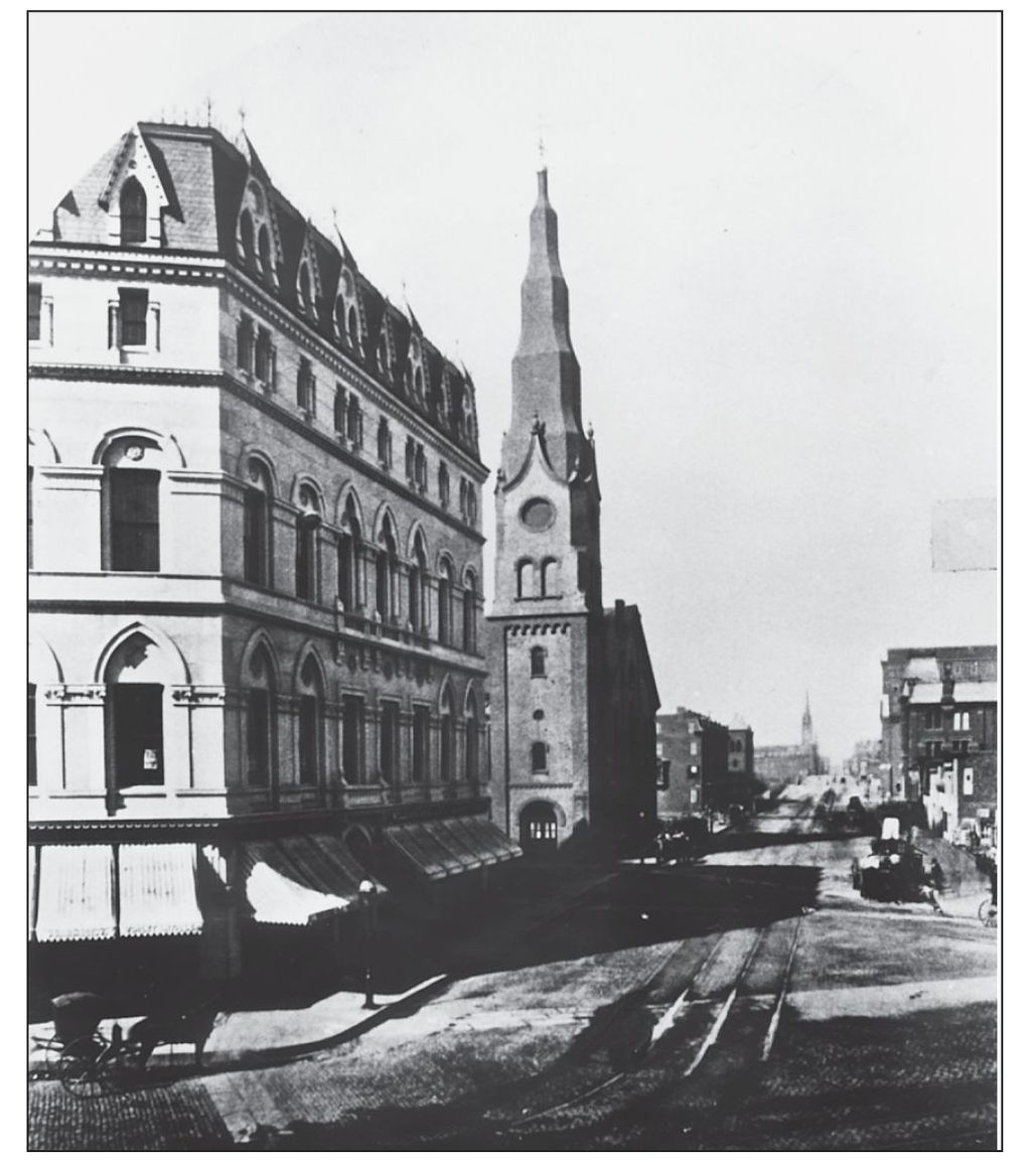
Odd Fellows Hall was built in 1872 of Concord and Hallowell white granite at the corner of Tremont and Berkeley Streets. Four stories in height with a mansard roof, the Odd Fellows’ Hall Association built the Ruskinian Gothic building for their own use. Odd Fellows had originated during the Industrial Revolution to secure a system of benefits to assist members during hard times, and it became a popular organization in nineteenth-century America.

Looking west on Tremont Street about 1875, one can see that the streetcar tracks stretch well into Roxbury. On the right is the Hotel Clarendon, which was burned in 1969; on the left are the spires of the Shawmut Congregational Church and the Tremont Street Methodist Episcopal Church. In the distance, just behind the trees on the right, can be seen the Saint Cloud, an elegant French flat apartment house. (Courtesy of the BPL.)
The building at 74 Montgomery Street was the home of George H. Tinkham, a merchant. His son was Congressman George Holden Tinkham. (Courtesy of the South End Historical Society.)


Dwight Street was laid out in 1859, connecting Shawmut Avenue and Tremont Street. Residents had to dig out from the blizzard of January 1867, which created a winter wonderland. (Courtesy of SPNEA.)

The Hotel Plaza and the famous Heidelberger Rathskellar were at 419 Columbus Avenue. Known originally as the Berwick Hotel, it was popular with tourists visiting the city. (Courtesy of the South End Historical Society.)

The Commonwealth Hotel, also once known as the Langham Hotel and the Hotel Washington, was built in 1869 as an impressive residential hotel on Washington Street at the corner of Worcester Street. The facade was fronted with marble and was “of a most handsome and ornate style of architecture.”

Williams Market was designed by Gridley J. Fox Bryant and opened in 1855 at the corner of Washington and Dover (now East Berkeley) Streets. An impressive Italianate market, it was within a residential area with townhouses on Dover Street on the left and two townhouses on Washington Street on the right. The building later became the New Grand Theatre, a vaudeville house, and is today the site of the South End landmark Harry the Greek’s. (Courtesy of the Boston Athenaeum.)

The Washington Market was opened in 1870 at the corner of Washington and Lenox Streets. Containing nearly one hundred foodstalls, the market was described as “clean and bright as well as roomy.” (Courtesy of SPNEA.)

This detail of the Map of the City of Boston in 1872 shows the South End, bound by Lenox, Albany, and Dover Streets and the tracks of the Boston and Providence Railroad (the dark band just above Columbus Avenue). The South End was created in the 1830s through infill; in just two decades it became a new and desirable neighborhood.