Diablo Lake in North Cascades National Park

East Coast loggers pushed west in the late 19th and early 20th centuries, downing mile after mile of the continent’s primeval forests. Today, almost all of the large ancient forests left in the Lower 48 states grow in the Pacific Northwest, most of them in national forests and the region’s six rugged national parks.
Visitors can hike the cathedral-like glades of Douglas fir, western red cedar, and other conifers of Mount Rainier, Olympic, and North Cascades in Washington. The redwoods in the California park named for them—Redwood National Park—include trees in their second millennium, some of the tallest on Earth. In Olympic, temperate rain forests soar near some of the nation’s wildest coastline; only there and at Mount Rainier do such forests still exist in the United States.
Washington State’s youngest park, North Cascades, is also its youngest mountain range, with the razor-sharp alpine peaks and deep valleys of geological youth to prove it. All of these ancient forests and mountain peaks knit together the lives of hundreds of species of plants, animals, and microbes in a web still being studied. Yet that web is increasingly threatened as trees in private, state, and national forests are cut down.
The Northwest is also known for its volcanoes, many of which, including Mount Rainier and Mount St. Helens, lie in the Pacific Ring of Fire, the great belt of crustal instability responsible for three-quarters of the world’s active volcanoes. Visitors to California’s Lassen Volcanic National Park can see evidence of the planet’s violence in broken mountains and boiling mud pots. To the north at Oregon’s Crater Lake, you can imagine the titanic forces that collapsed a mountaintop, turning it into a lake 6 miles wide and the nation’s deepest. And it’s easy to marvel at the majesty of cloud-swathed Mount Rainier, which grew on a foundation of lava flows from extinct volcanoes, and now shoulders breathtaking wildflowers and more glaciers than any other U.S. peak south of Alaska.

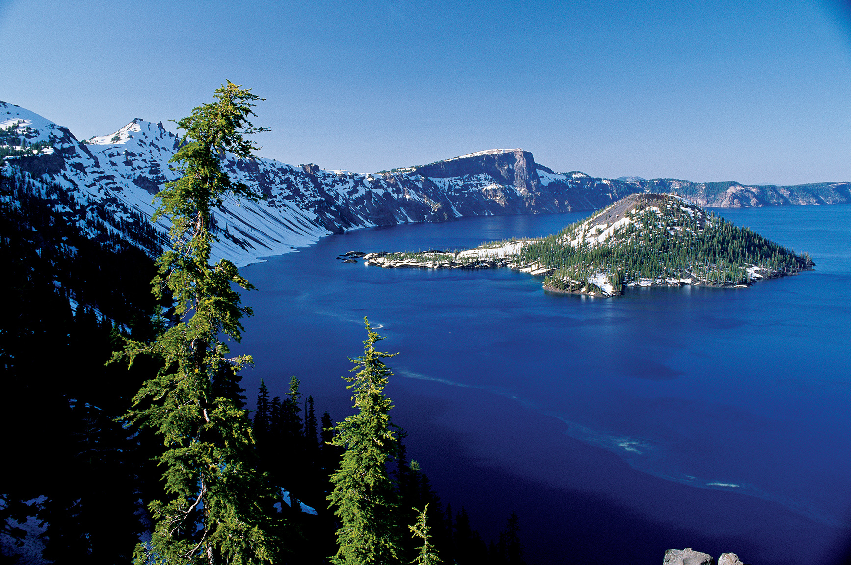
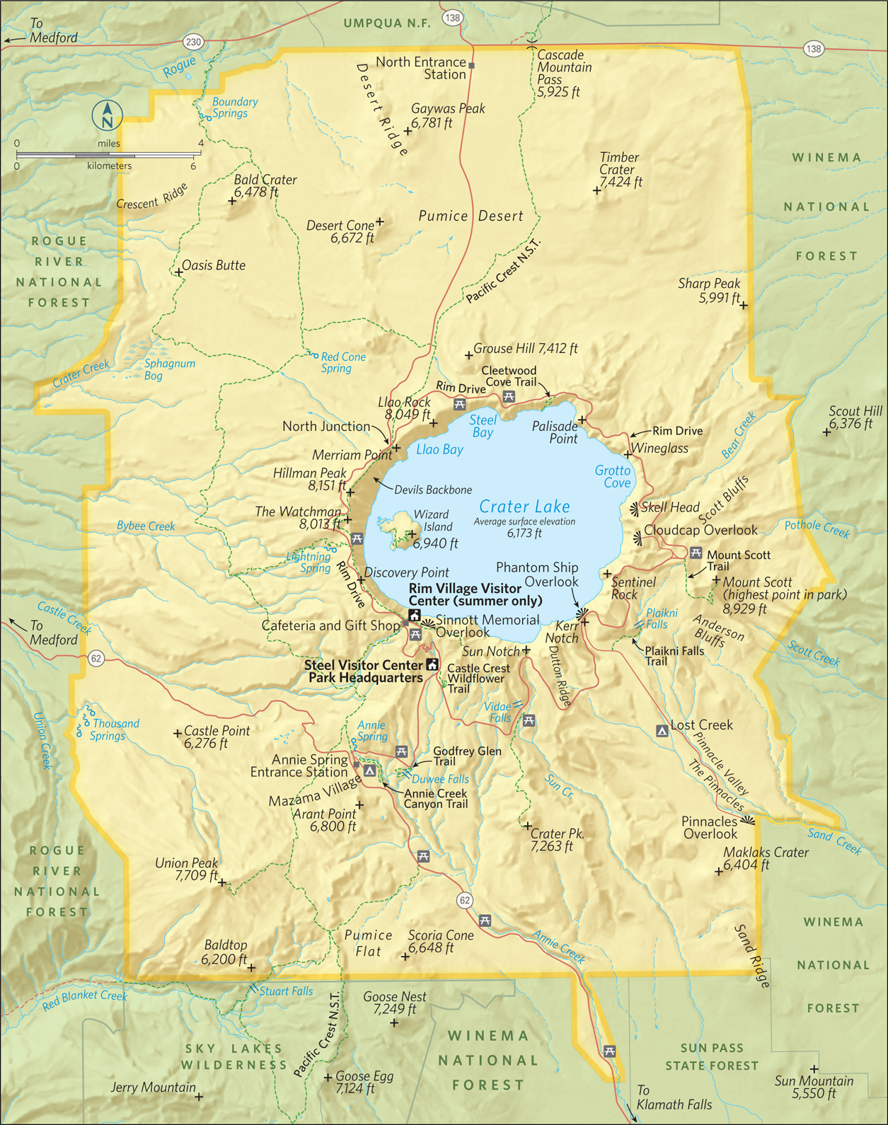
Snowmelt feeds Crater Lake.
Oregon
Established May 22, 1902
183,224 acres
More than 5 trillion gallons of water fill the crater—what remains of Mount Mazama. With a surface area of 21 square miles and depth of 1,943 feet, Crater Lake is the deepest lake in the United States. In addition the size of Crater Lake National Park, it is the stunning sapphire water that etches itself in memory.
Nearly 8,000 years ago, Mount Mazama in southern Oregon exploded in an eruption 100 times more powerful than the one that decimated Mount St. Helens in 1980. During the ancient cataclysmic eruption, the mountain basically collapsed in on itself to form a vast cliff-lined basin. Over the centuries, precipitation, mostly in the form of snow (524 inches a year on average), flowed in the caldera and, with no outlet to drain the water, Crater Lake was born. Nestled near the western shoreline, Wizard Island represents Mazama’s attempt to rebuild itself. It was pushed up by volcanic activity some 2,500 years after the eruption.
While the core of the park is Crater Lake itself, the surrounding mountains and high plateaus offer visitors unique lessons on volcanic terrain.
Park highlights can be experienced in a day, but a long weekend is best. For single-day visits, plan an early start from Rim Village to get the dramatic early-morning light across the lake. Start north on Rim Drive to complete the 33-mile loop clockwise for best viewing and lighting throughout the morning. Stop to take the short hike up the Watchman Trail for a look east across the blue lake before continuing to the north rim.
The Cleetwood Trail leads down to the lakeshore. The hike is easy, but be prepared for the steep 1-mile return (there is no other way to get back to the rim). The final leg of the loop runs through the forests and valleys south of the lake.
Rim Drive
Rim Drive circles the lake, but not always along the rim of the caldera. Rim Village, on the southwestern corner of the crater, offers grand views of the lake from the Sinnott Memorial Overlook. From here, the broad expanse of the deep blue lake seems to mock the sky by offering itself as a truer, richer blue.
The lake’s mesmerizing color results from its absolute clarity. As light penetrates the lake there are no impurities to reflect it. And since water molecules absorb all light in the spectrum other than blue, only the blue light is reflected back.
Leaving Rim Village, head north along the Rim Drive. Plan to take your time as the road is curvy and narrow—and can be crowded in peak season. (Note that trailers and oversize vehicles are not recommended on the eastern half of the drive.) Just over a mile from Rim Village, pause at Discovery Point.
It was near here in 1853 that a group of gold seekers found themselves standing on the rim, looking down on what they casually named Deep Blue Lake. This was the first recorded non-native visit to the lake, but with no way to reach the lake itself, the prospectors had no choice but to continue north on their quest for gold.
At Mile 4, stop and stretch your legs. The 0.8-mile Watchman Trail affords one of the best hikes in the park, with views directly down onto Wizard Island. Just north stands Hillman Peak. The 8,151-foot summit marks the highest point on the actual crater rim. Named after the gold hunter who funded the prospecting expedition that recorded the existence of the lake in 1853, the rocky crag of Hillman Peak is all that remains of what was once a secondary volcano on the flank of Mount Mazama. When Mazama erupted and the summit collapsed, it took most of Hillman with it.
Continuing north, the road forks at 6.1 miles. Stay right to continue on the Rim Drive; it is here that the road becomes too narrow and winding for oversize vehicles. The road angles well away from the crater rim for the next 2 miles before reaching a picnic area high above Steel Bay.
The bay’s namesake, William Gladstone Steel, first read about the lake in an 1870 Kansas newspaper. His family moved to Portland, Oregon, in 1872; Steel visited the lake in 1885. From that moment on, he worked tirelessly to preserve Crater Lake. His efforts came to fruition after he made a personal pitch to President Theodore Roosevelt. Roosevelt signed the legislation designating Crater Lake National Park early on in the 20th century, making it our sixth national park (just four years after another northwest park, Mount Rainier, became the fifth national park in the United States).
Just beyond Steel Bay is the trailhead of the Cleetwood Cove Trail, which usually opens mid- to late June. The path descends 1.1 miles from the rim to the lakeshore along a modest grade carved into the wooded slopes of the northern edge of the caldera. The trail ends at a boat dock from which a park concessioner operates a motor launch for trips along the lake. In addition, this is the only place where it is safe and legal to be on the lakeshore. Visitors here are welcome to swim in the cold, cold lake.
Near the 15-mile mark of Rim Drive Skell Head observation point provides open views west across the lake to Wizard Island and Hillman Peak above it. The 8,929-foot mountain just to the east of Rim Drive boasts an old fire lookout tower, and provides stunning views west across the breadth of the lake.
A mile farther on is the start of the Mount Scott Trail. The 2.5-mile trail climbs steeply at times, through piercing fragrant pine forests and brilliant wildflower meadows, before reaching the summit.
At Mile 24, stop at Phantom Ship Overlook to peer down at Phantom Ship—the only other island on the lake besides Wizard. The outline of Phantom Ship resembles a pirate’s ship and gains its name from the fact that it disappears completely against the crater’s walls when viewed from much of the rim. Make your way to Kerr Notch, where the phantom ship is easily viewed.
Past Kerr, Rim Drive veers away from the crater and weaves through the rich forest ecosystem of the mountain’s southern flank. The gentle Castle Crest WIldflower Trail, near park headquarters, provides fascinating information about the local flora and fauna. The trail meanders through meadows awash with delicate wildflowers during most of the summer.
The Lake
To experience the lake itself, hike down the mile-long Cleetwood Trail to the dock on the shore of the lake. From here, concessioner Xanterra (888-774-2728) offers boat tours of the lake.
The standard interpretive boat tour circumnavigates the broad lake in two hours, providing fine lessons on the geology and history of Crater Lake as you take in the vast beauty of the lake and its surroundings. Indeed, the tour comes with great views of Phantom Ship and the cinder-cone peak of Wizard Island. The standard tour runs hourly during peak season, typically July through September.
A thorough exploration of Wizard Island is also possible, with optional half-day or all-day drop-offs that allow time to get a sense of this volcanic cinder cone. From the island dock, a mile-long trail weaves upward through a series of switchbacks to the crater at the cinder cone’s summit (6,940 feet). The rim of this crater within a crater provides views of the lake that only a tiny fraction of visitors ever get to see.
Information 
|
How to Get There Ore. 62 cuts through the southern portion of the park complex, providing access from Medford. US 97 runs just east of the park, offering access to the north end by way of Ore. 138. Nearby airports: Klamath Falls Regional Airport and Roge Valley International Airport, in Medford. When to Go Because of the park’s position high in the Cascade Mountains, winter comes early and lingers long. Most of the park’s roads aren’t clear until late June or early July (they start gathering snow in late Oct.). The Rim Drive typically closes for the winter season by Nov. 1. Rim Village remains open year-round for winter recreational activities. Visitor Centers The Rim Village Visitor Center, located along the rim 7 miles north on Ore. 62, is open late May through late Sept. Steel Visitor Center 4 miles north of Ore. 62 operates year-round. |
Headquarters P.O. Box 7 Camping The park complex offers two campgrounds, Mazama Campground has 200 sites, three-quarters of which may be reserved (craterlakelodges.com). The 16 tent sites at Lost Creek Campground are first come, first served. A free permit, available from park headquarters, is needed for backcountry camping. Lodging Crater Lake Lodge at Rim Village (mid-May through Oct.) and the Cabins at Mazama Village (mid-May through mid-Oct.) are both operated by Crater Lake Lodge (craterlakelodges.com). For lodging outside the park check with the Klamath County Chamber of Commerce (klamath.org/visitors/) or the Medford/Jackson County Chamber of Commerce (medfordchamber.org). |
Chiloquin, Oregon
▷ An important nesting, feeding, and staging habitat for waterfowl and the sandhill crane, the Klamath Marsh Refuge, located along the Williamson River, is a sanctuary designed for the bird-lover. With 40,000 acres of wet meadows and open-water wetlands, the refuge is home to the Oregon spotted frog, a candidate for the endangered species list. Canoeing, kayaking, fishing (after July 1). Located 71 miles east of Crater Lake National Park, off US 97. fws.gov/refuge/klamath_marsh; 541-783-3380.
Newberry National Volcanic Monument
Bend, Oregon

▷ At more than 54,000 acres, Newberry National Volcanic Monument offers plenty of opportunities to view the “Lava Lands” of central Oregon from atop an active volcano. The monument includes lava tubes, cinder cones, obsidian flows, and an eerie forest of lava casts. Camping, fishing, biking, and hiking. Some facilities and trails open only seasonally. Located 100 miles north of Crater Lake National Park, via US 97N. fs.usda.gov/recarea/deschutes/recarea/?recid=6615966159; 541-593-2421.
Oregon Dunes National Recreation Area
Reedsport, Oregon

▷Towering dunes—some as high as 400 feet—stretch along the Pacific coast, inviting exploration. Fully 32,000 acres are open to off-road vehicles. The area shelters 426 wildlife species, including black bear, black-tailed deer, and tundra swan. Hiking, camping, boating, fishing, horseback riding, and swimming. Located 200 miles west of Crater Lake National Park, off US 101. fs.usda.gov/recarea/siuslaw/recarea/?recid=42465; 541-271-6000.
Oregon Caves National Monument
Cave Junction, Oregon

▷ Found deep in the Siskiyou Mountains are the caves commonly known as the “Marble Halls of Oregon.” The caves formed as acidic groundwater from the ancient forest above dissolved the surrounding marble creating the formations. Indeed, this is one of the world’s few marble caves. Guided tours offered late March through the end of October. Located 130 miles southwest of Crater Lake National Park, off US 199. nps.gov/orca; 541-592-2100.
Prospect State Scenic Viewpoint
Prospect, Oregon
▷ The small, idyllic Prospect State Scenic Viewpoint is tucked away in a secluded forest area with picnic tables and hiking trails that lead to Pearsony Falls, the Rogue River, and Mill Creek Falls. Hiking, picnicking, and wildlife viewing. (No potable water.) Located 22 miles southwest of Crater Lake National Park via Oreg. 62W. oregonstateparks.org; 541-560-3334.
Grants Pass, Oregon

▷ The 84 miles of the scenic Rogue River, stretching from Grants Pass to Gold Beach, vary from the rush of white water to water smooth as glass. Wildlife to spot: salmon, bald eagles, osprey, and mink. Whitewater rafting, canoeing, swimming, fishing, bird-watching. Also on tap are jet boat tours (fee). Located 80 miles from Crater Lake National Park via I-5. blm.gov/or/resources/recreation/rogue; 541-471-6500.
Volcanic peaks and thick forest
California
Established August 9, 1916
106,000 acres
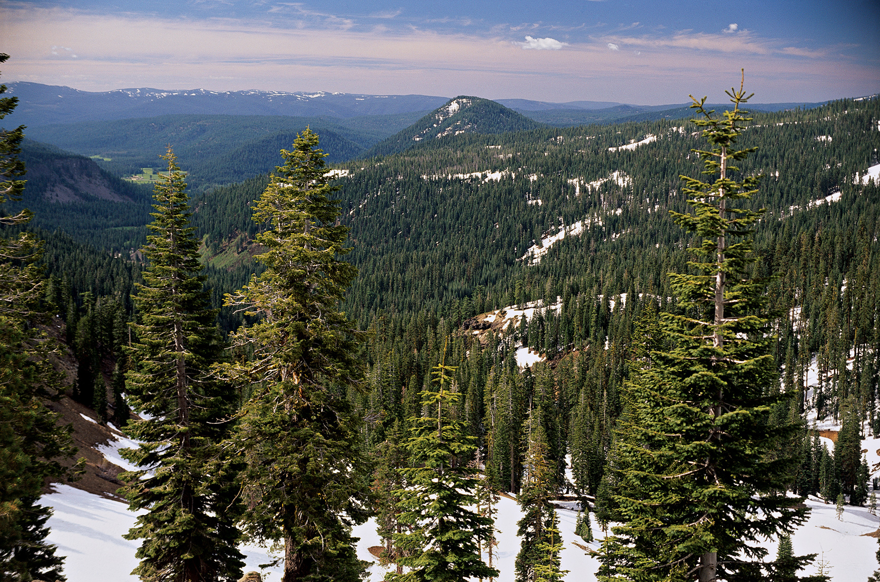
One of the least discovered parks in the western United States, Lassen Volcanic National Park is a real-world laboratory that shows how landscapes evolve over time following a major volcanic eruption. Boiling springs, mudflows, lava fields, and cinder cones reflect the park’s violent geologic legacy. But Lassen is much more than basalt and ash. The park also harbors numerous lakes and meadows, thickly forested areas, and a rich catalog of wildlife.
The origins of this volcanic landscape stretch back more than three million years, when powerful mudflows, or lahars, rushed down the flanks of Mount Yana, covering a 2,000-square-mile area—including what is now Lassen Volcanic National Park. There has been volcanic and hydrothermal activity ever since, culminating in a massive stratovolcano called Brokeoff Mountain (Mount Tehama), which dominated the landscape between 600,000 and 400,000 years ago. When American explorers and pioneers first reached the area in the early 19th century, they most likely assumed the volcanoes were dormant. So it would have come as a huge surprise when Lassen Peak rumbled to life in 1914, a three-year episode that included a massive eruption in May 1915 that spewed ash, rock, and lava over much of the park’s northwest quadrant.
Even before that last eruption, Lassen was deemed a geological wonder. In 1907, President Theodore Roosevelt designated both Cinder Cone and Lassen Peak as national monuments. A year after the 1915 eruption, they were combined into Lassen Volcanic National Park, one of several units of the nascent national park system.
The park is unique on several levels. It’s one of the few places on Earth where visitors can view all four volcano types—plug dome, cinder cone, shield, and composite—within a relatively small area. Lassen Peak is the southernmost active volcano in the Cascade Range. Lassen and Mount St. Helens were the only volcanoes to erupt in the Lower 48 states during the 20th century.
All told, more than 75 percent of the park is designated Wilderness—easily accessed, even via day hikes.
► HOW TO VISIT
Nearly everyone who visits the park drives the the 30-mile stretch of Lassen Volcanic National Park Highway that meanders past volcanic peaks and through hydrothermal areas between the Kohm Yah-mah-nee Visitor Center and Manzanita Lake.
While the scenic drive reaches many of the tectonic highlights, it offers only a hint of Lassen’s pristine backcountry. Less-traveled unpaved roads take visitors to secluded spots like Cinder Cone and Butte Lake in the park’s northeast corner and the hydrothermal splendor of Warner Valley in the south, as well as quiet Juniper Lake in the southeast.

Lassen Volcanic National Park Highway
The 30-mile drive, part of the Volcanic Legacy Scenic Byway, offers spectacular vistas, trailheads to hydrothermal landmarks, and picnic areas where you can kick back and enjoy the view. Located just beyond the southwest entrance, Kohm Yah-mah-nee Visitor Center provides a broad introduction to the park’s wonders, with exhibits and a short video on local history and nature. From the terrace behind the visitor center, you can gaze upward at Mount Diller, Diamond Peak, Pilot Pinnacle, and the other ragged mounts that once formed the base of Brokeoff Volcano.
Stock up on food, drinks, and reading material at the visitor center stores—no provisions are available between here and Manzanita Lake.
Making your way north on the highway, your first stop should be Sulphur Works (Mile 0.8), a mosaic of fumaroles (steam vents) and mudpots that tumbles down the mountain slopes on both sides of the road. The smoldering hillside, easily the most accessible of the park’s hydrothermal features, derives its name from the odorous hydrogen sulfide escaping from the vents.
After twisting around Diamond Peak, the highway continues its climb to petite Emerald Lake and the Bumpass Hell parking area (Mile 5.8).
Looking northward, the view takes in mirror-like Lake Helen and towering Lassen Peak (10,457 feet), named after Peter Lassen, an early-19th-century Danish blacksmith, rancher, and prospector who pioneered the region. To the south are Little Hot Springs Valley and a seemingly endless spread of mountain ridges. One of the park’s most popular hikes leads 3 miles downhill to Bumpass Hell, a large and very active hydrothermal basin best viewed from the boardwalk that hovers very close to the bubbling pools.
Those planning to scale Lassen Peak should pull into the parking area at Mile 7.1, which marks the start of a steep 2.5-mile trail to the summit.
After breaching the highest point along the highway (8,512 feet), the road plunges downward into Kings Creek Meadow. At Mile 13.1 you’ll see a turnout for the trail to Kings Creek Falls, which tumbles 50 feet over a lava ledge.
Linger along the shore of tranquil Summit Lake (Mile 16.5), warm enough in summer for a swim. The highway continues northward to an area ravaged by the 1915 eruptions. Having largely recovered from the volcanic havoc, the Devastated Area (Mile 19.8) now seems misnamed. But a short interpretive trail describes the violent pyroclastic flow that decimated this area just a century ago.
Nobles Emigrant Trail—a popular covered-wagon route during the mid-19th century—crosses the highway at several places, including Mile 26.3, where the pioneer path is still visible through the woods, just beyond the historical marker.
The pines soon give way to Chaos Jumbles (Mile 27.5), the remains of a rock avalanche that raced across the landscape some 350 years ago at an estimated 110 miles per hour. Unlike the Devastated Area, the Jumbles remains a no-man’s-land of volcanic demolition, strewn with giant boulders and dwarf trees. Civilization reappears at Manzanita Lake (Mile 29.3), with its cabins, campground, and store.
Loomis Museum, housed in a historic stone building erected in 1927, displays dramatic black-and-white photos of Benjamin Loomis, who risked life and limb to capture the 1915 eruption on film. From Memorial Day through Columbus Day (weather permitting), the Manzanita Lake camp store rents kayaks for forays onto the lake.
Elsewhere in the Park
The pristine Butte Lake area is accessed via Calif. 44, along the northern edge of the park. With thick woods on one shore and the Fantastic Lava Beds on the other, the lake offers a stark contrast in Lassen landscapes. Starting from the lake parking area, you can follow a section of the old Nobles Emigrant Trail along the jagged edge of the lava beds to Cinder Cone. Amazing and menacing, the 6,907-foot mount is composed of volcanic scoria rock discharged from the earth around A.D. 1666. A spur trail leads to the cone’s summit and its shallow crater. The view from the top is perhaps the best in the park, a dramatic panorama of the nearby lava beds and Painted Dunes with Lassen Peak (and others) on the western horizon.
Tranquil Juniper Lake lies at the end of a 13-mile road from Chester, on the park’s southern flank. A ranger station and primitive campground are the only facilities, but you can bring in your own canoe or kayak and paddle the lake. Hiking trails lead to nearby sights like Snag Lake (at the southern end of the Fantastic Lava Beds) and the vintage 1930 fire lookout tower atop Mount Harkness, an 8,048-foot-high shield volcano.
Chester is also the starting point for the 17-mile drive to Warner Valley and its hydrothermal wonders. In addition to swimming in the naturally heated pool at Drakesbad Guest Ranch, you can hike or ride horses to local “hot spots” like Terminal Geyser and Devils Kitchen. Warner Valley is also the best place in the park to access the Pacific Crest Trail, which cuts a zigzag path right across the middle of Lassen.
Information 
|
How to Get There From Sacramento, CA (about 180 miles south), take I-5 north to Exit 649 in Red Bluff, then Calif. 36 east to Calif. 89 north. The park’s southwest entrance and visitor center are about 5 miles from the 36/89 junction. Other routes include Calif. 44 from Redding, CA, to the Manzanita Lake Entrance Station, and a combination of US 99, Calif. 70, and Calif. 89 from Sacramento to the southwest entrance. When to Go The park is open year-round, but many park facilities are closed generally between mid-Oct. and late May. The main park highway is closed during the winter season, and the Kohm Yah-mah-nee Visitor Center may close at any time due to weather. Visitor Center Kohm Yah-mah-nee, about 5 miles north of the turnoff from Calif. 36, is closed Mon. and Tues. early Dec. through March. |
Headquarters P.O. Box 100 Camping Eight developed campgrounds (430 sites) take reservations (recreation.org; 877-444-6777). Backcountry camping requires a free permit (530-595-4480 for information, or visit the Kohm Yah-mah-nee Visitor Center). Lodging Lodging is limited to two park locations open June to mid-Oct. The historic Drakesbad Guest Ranch (drakesbad.com; 866-999-0914) is 17 miles north of Chester, CA, in Warner Valley, and the Manzanita Lake Camping Cabins is in the park’s northwest corner (lassenrecreation.com; 877-444-6777). For other choices check nps.gov/lavo/planyourvisit/lodging.htm. |
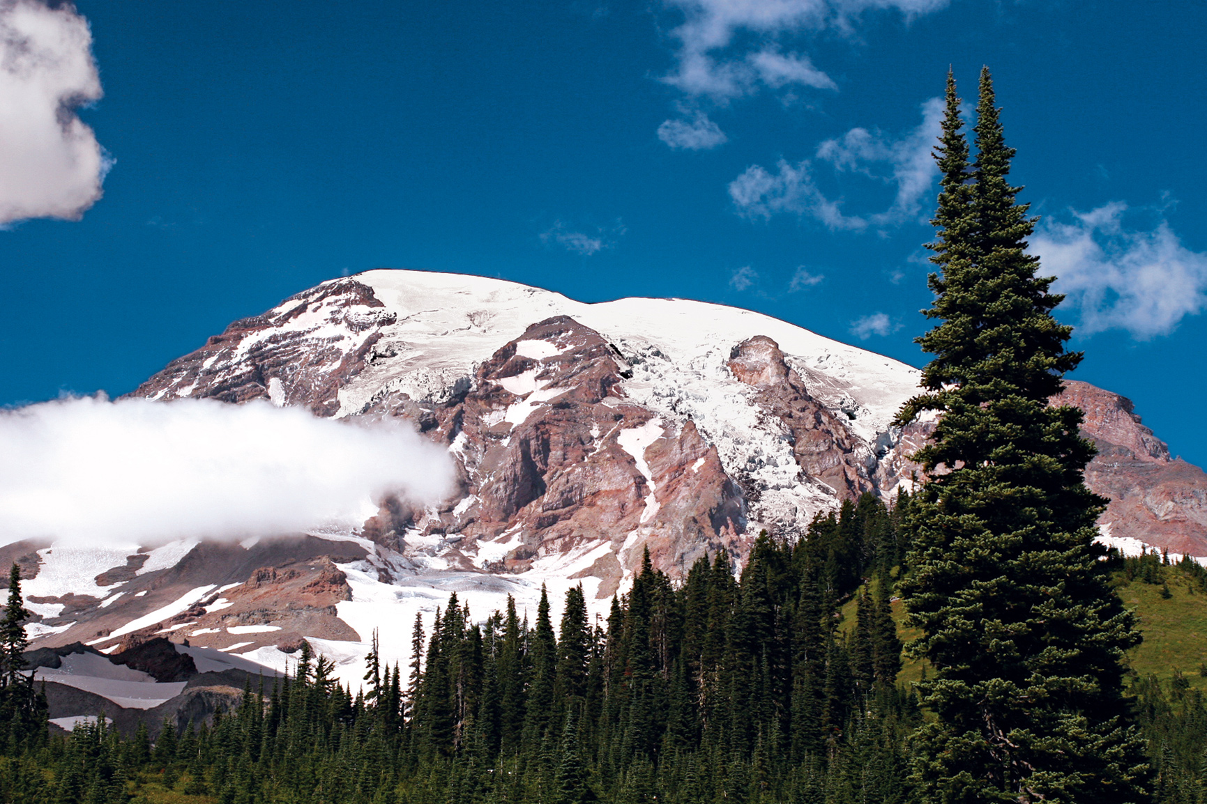
Mount Rainier
Washington
Established March 2, 1899
236,381 acres
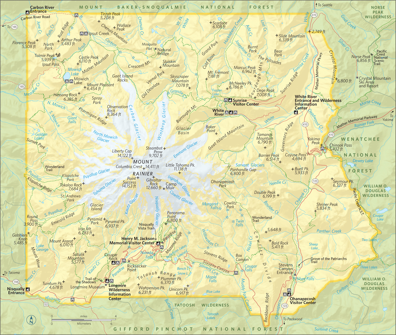
Towering nearly 8,000 feet above the neighboring Cascade peaks, Mount Rainier forms the roof of Washington State, reaching 14,411 feet into the sky. Mount Rainier National Park, in all its diversity, represents a unifying icon for Washington’s grand landscapes. The great mountain can be viewed from hundreds of miles away, from every compass point. It is the most identifiable landmark around.
For centuries, Tahoma—the name given to the mountain by native tribes—represented a mighty source of power. Centuries on, many believe that Mount Rainier National Park owes its status in large part to the citizens of Seattle and Tacoma, who recognized the majesty of the area. Rainier and its surrounding forests were designated Mount Rainier Forest Reserve in 1893; six years later it was designated a national park.
The park boasts an array of terrain, including vast fields of flower parklands. Beyond the meadows are more than 300 lakes, dozens of waterfalls, 25 glaciers, and 50 permanent snowfields.
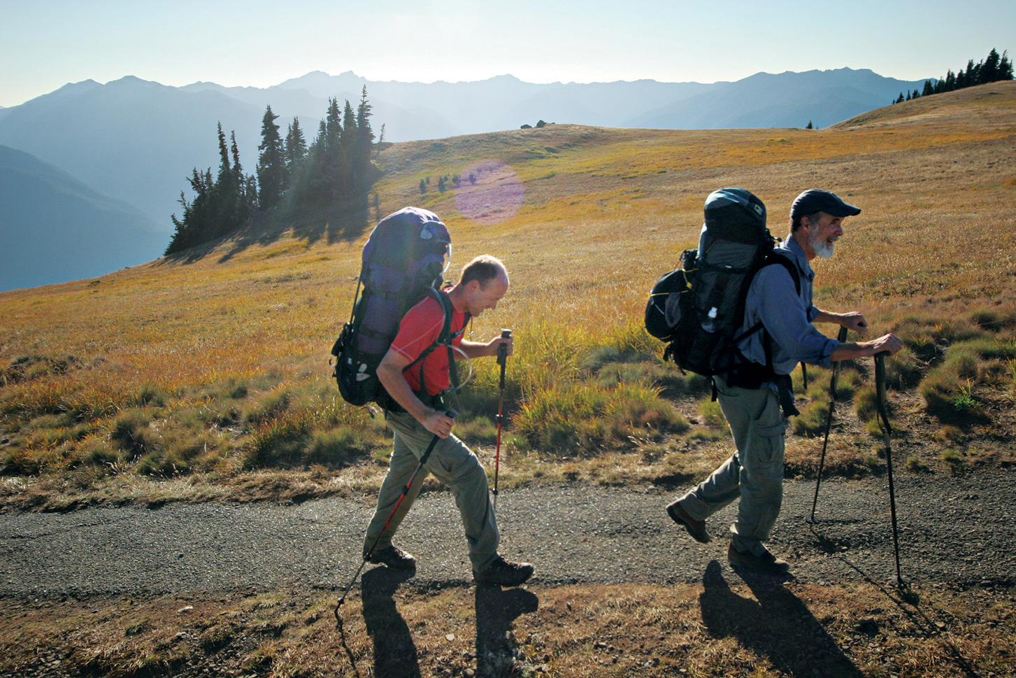
For a summer visit, travelers can see the best of the park in a day provided they get an early start. Begin at the White River Entrance and follow the road to its end, Sunrise Visitor Center. From here, on a clear day, the northeastern face of Mount Rainier sparkles in the first light of the day. From Sunrise, continue on to the Stevens Canyon Entrance to explore some more. In late afternoon, head to the heavenly meadows of Paradise. Linger here into the evening for the chance to catch the peak bathed in the amber light known as alpenglow. With more time, head to the park’s northwest corner far off the beaten path.
If planning a winter visit, Paradise Basin, on Mount Rainier’s southern flank, offers some of the best and most accessible snow recreation in the Pacific Northwest. The National Park Service keeps the road from Longmire to Paradise plowed and open year-round, conditions permitting; the road is closed at night. Most other roads open late June or early July and close by early December.
Because the snowpack typically tops 20 feet or more, snowshoers and cross-country skiers are free to ramble anywhere they’d like in Paradise Valley. Check the weather and avalanche conditions prior to heading out.
When snow levels drop mid-winter, snowshoers also find great options in the Longmire area. The Trail of the Shadows and the section of the Wonderland Trail from Longmire east along the Nisqually River are two easy snowshoe routes.
East Side: Sunrise & Stevens Canyon
From the White River Entrance, the road leads to White River Campground and great hiking opportunities up the Glacier Basin Trail. The road climbs away from the river and switchbacks up to a long ridge ending at Sunrise. Look for climbers on the glaciers directly above Steamboat Prow—a V-shaped rock a third of the way up the mountain’s face.
Several trails leave Sunrise, all with grand views of the towering northeastern face of Mount Rainier. For a short exploration of the ridgetop meadows, venture up the 1.5-mile Sourdough Ridge Nature Trail, with fine views and good examples of the local flora and fauna.
For a longer hike with a bit more history, push on west along Sourdough Ridge to Frozen Lake (1.2 miles from Sunrise) and on up to a stony promontory at the end of Fremont Ridge, just 2.8 miles from Sunrise. Here stands a rustic wooden fire tower. Fremont Lookout was in use throughout the first six decades of the 20th century.
A less strenuous hike can be found by angling south along the Burroughs Mountain Trail from Frozen Lake. The trail rolls over the nearly flat summit of First Burroughs at 2.5 miles, and then climbs a half mile to Second Burroughs. Both ridge-top summits provide panoramic views of Rainier and its flanking peaks. Other destinations to explore out of Sunrise include Berkeley Park, Grand Park, Skyscraper Peak, and Shadow Lake.
After exploring the Sunrise area you can head south on Wash. 410 and Wash. 123 to the Stevens Canyon Entrance. Head up Stevens Canyon Road and stop near the Stevens Canyon Entry Station to walk the 1.5-mile trail into the Grove of the Patriarchs. To get into the grove, located on a large island in the Ohanapecosh River, you’ll have to cross a scenic, and swaying, suspension bridge. The stand of massive old trees shows the grandeur of Washington’s old-growth forests. Some of the grove’s 1,000-year-old hemlocks, Douglas firs, and western red cedars tower nearly 300 feet tall and rival California’s redwoods in girth.
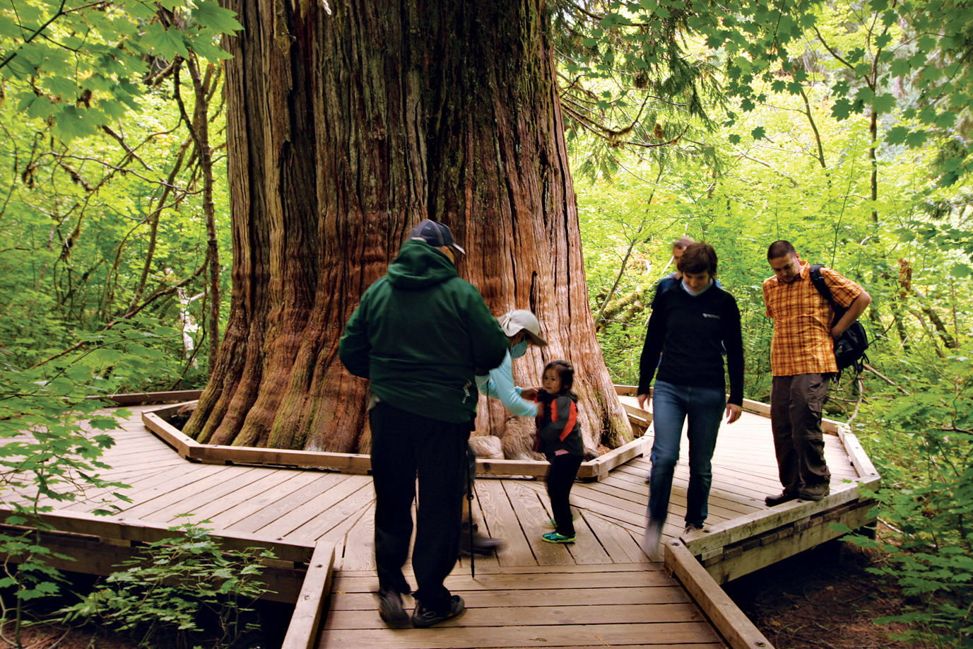
A western red cedar
South Side: Stevens Canyon & Paradise
A drive west from the Stevens Canyon Entrance leads up the long, deep cut of the canyon. Nearly 10 miles west of Wash. 123, stop at Box Canyon. A half-mile trail wanders along the Cowlitz River—or rather, along the top of the 100-foot-deep slot canyon carved by the Muddy Fork of that river. Head 1 mile north along the gorge to reach the Nickel Creek backcountry camp.
As the road climbs west, it reaches Reflection Lakes, about 16 miles from Wash. 123. Park here for a grand roadside photo op: the looming summit and its reflection in the shallow lake.
Hiking opportunities in this part of the park include a gentle stroll around the small lake; the 1.3-mile trail to Pinnacle Peak; and, above the Stevens Canyon Road, a trail (under a mile) through tree-studded meadows that leads to Bench Lake. The far side of the lake is bordered by a rim of rock that drops away in a dramatic cliff, making Bench something of a naturally occurring infinity pool. The trail climbs south a half-mile away from Bench to Snow Lake in the deep cleft of rock below Unicorn Peak.
Beyond Reflection Lake, the road leads upward to Paradise. This heavenly alpine landscape earned its name in 1885. The daughter-in-law of the original settler in the area, James Longmire, ventured into the meadows for the first time and declared, “Oh, what a Paradise.”
In the early part of the 20th century, sprawling campgrounds and a small golf course marred the spectacular meadows; those blemishes have since been removed and revegetation initiated
The meadows today are almost just as they were when Martha Longmire first saw them more than a century ago. Of course, the best way to experience the grandeur of the area is by foot. A strenuous 1.7-mile loop up to Alta Vista offers meadow views and summit scenery. A 1.2-mile trail leads out along the edge of the Nisqually Glacier valley with views south to the Tatoosh Range.
The best route for those up for a strenuous hike is the 4-mile loop up along Skyline Trail. Panorama Point, along the way, is the start of the climber’s route to Camp Muir at the 10,188-foot level and on to the summit.
Leaving Paradise, you’ll descend the Paradise River Valley to its junction with the Nisqually River. Just a couple miles from Paradise, stop at Narada Falls. A 0.25-mile trail leads to grand views of the 168-foot fantail cascade.
Just over 11 miles from Paradise awaits Longmire. Natural springs in these forested meadows prompted James Longmire to construct a hotel and spa in the 1880s. Though not the Longmire original, a hotel—the National Park Inn—is an overnight option for today’s travelers.
Learn about the park’s history at the Longmire Museum, and explore the trails that meander through the area. The Trail of the Shadows, an interpretive route, loops through the meadows, while day hikers can venture up Eagle Peak, Rampart Ridge, or along the local stretch of the 93-mile Wonderland Trail that encircles Mount Rainier.
Northwest Corner: Mowich Lake & Carbon River
While nature lovers and adventurers such as John Muir and James Longmire climbed the mountain and explored the southern portion of what became Mount Rainier National Park, another sort of explorer ventured into the northwest corner.
Throughout the early 20th century, miners dug under the hills of the upper Carbon River basin, searching for everything from coal to gold. The good news is that the rich forest ecosystems quickly healed the scars left by those seeking to take the region’s riches, reinstating riches of a more respectful type.
From Wash. 410 in the town of Buckley, turn south on Wash. 165 and follow it into the Carbon River Valley, where the road forks. Wash. 165 climbs away from the river to Mowich Lake, while the Carbon River Road leads to the northwestern corner of the park. There the road is closed to automobile traffic.
Mountain bikes are allowed on the 5 miles of closed road from the park boundary to Ipsut Creek, but riders must get off their bikes and hike if they want to discover part of the 8.5-mile Carbon Glacier Trail.
Beyond the Carbon River, Wash. 165 becomes a gravel road, making the final 10 miles to Mowich Lake a bit dusty and rough. But from the shores of Mowich, visitors can explore a number of trails with spectacular views and scenic wonder. The Tolmie Peak Lookout Trail (2.8 miles) wanders around the perimeter of Mowich Lake before climbing to the old fire lookout tower atop the peak.
The 3-mile Spray Park Trail weaves in and out of the park, straight up the flank of Mount Rainier itself, climbing above timberline to a sprawling alpine parkland on the edge of the mountain’s glacier fields.
Information 
|
How to Get There From Seattle (95 miles northwest), travel via I–5, Wash. 512, and Wash. 7 to the Road of Paradise. From Packwood (10 miles south), take Wash. 123 and Stevens Canyon Rd. to the Ohanapecosh Entrance. Check the park website for driving details. When to Go The Nisqually Entrance to Paradise is open year-round. Most other roads open late June or July and close by early Dec. Wildflowers in the Paradise and Sunrise areas peak in early Aug., as do the crowds. Backcountry trails are snow-clogged until mid-July. Mid-Sept. typically offers good weather and fewer crowds. Visitor Centers & Museum Longmire Information Center, open year-round; Longmire Museum and Ohanapecosh Visitor Center, open May–Oct.; Henry M. Jackson Memorial Visitor Center, open May–late Oct. and weekends the rest of the year; and Sunrise Visitor Center, open July–Sept. |
Headquarters 55210 238 Ave. E. Camping Two of the park’s three campgrounds, Cougar Rock and Ohanapecosh, allow reservations during peak season and generally fill up. White River Campground is first come, first served. The Forest Service maintains campgrounds near Mount Rainier at La Wis Wis, The Dalles, and American River. NPS and USFS sites may be reserved at recreation.gov (626 sites). Backpackers need backcountry camping permits. For information, 360-569-4453. Lodging The facilities in the park, National Park Inn (25 rooms) and Paradise Inn (open May through Oct., 121 rooms), are operated by Mount Rainier Guest Services (mtrainierguestservices.com). For lodging in neighboring communities: visitrainier.com. |
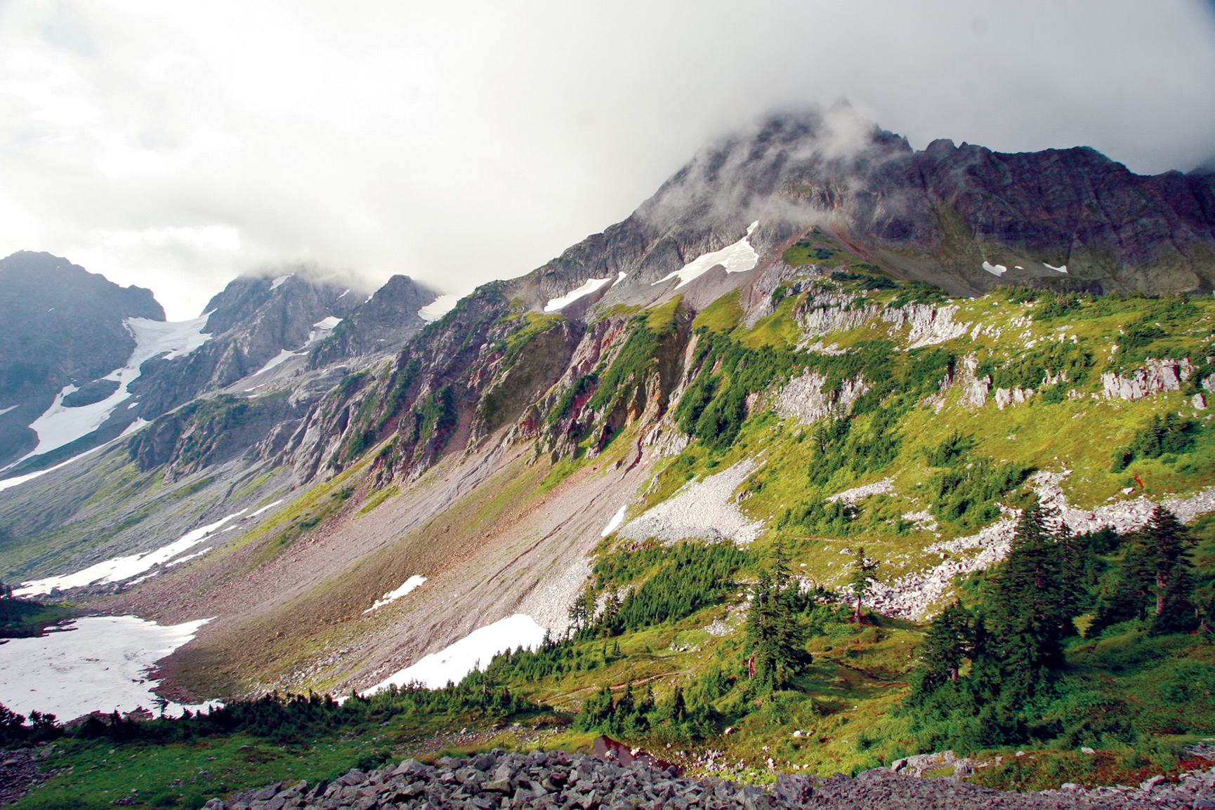
Jagged peaks crown more than 300 glaciers.
Washington
Established October 2, 1968
504,000 acres
At some 2 million years old, Washington’s Cascades are among the youngest mountains on the continent. The peaks are jagged and tall, not yet worn down by the ravages of time. The valleys are deep and sharp-edged because the rivers are still at work on the tough stone. And the flora and fauna are resilient, surviving and thriving in the challenging vertical world of North Cascades National Park.
This is not simply a park—it’s a sprawling wilderness complex that encompasses the national park as well as the Ross Lake National Recreation Area and the Lake Chelan National Recreation Area. These three units add up to some of the most rugged and remote wilderness in the United States. The high peaks and deep valleys cradle more than 300 glaciers.
The early explorers who traveled these mountains quivered at the thought of having to return the same way they came. The peaks bear names that inspire dread: Mount Terror, Mount Despair, Mount Fury, Desolation Peak, Mount Challenger, and Damnation Peak, to name a few.
North Cascades is more than rocks and ice, however. The park complex holds one of the last intact ecosystems in the country. Nearly all the species that lived here when Europeans first reached North America, from grizzly bears to tiny butterflies, can still be found here.
Wild runs of chinook (king) and sockeye salmon fill the rivers during spawning season, which brings out bald eagles and ospreys, as well as otters. Mountain lions and wolves hunt the complex’s black-tailed deer and mountain goats, while wolverines stalk anything that comes their way.
Towering Douglas fir and western hemlock dominate the forests of the northern and western portions of the park complex, which receives more than 100 inches of precipitation a year. Across the Cascade Crest, in the Lake Chelan National Recreation Area and the southern part of the park, forests tend more toward drought-hardy ponderosa pine, larch, and red fir. East of the crest, rainfall is 35 inches a year.
The sheer ruggedness of the park complex makes it challenging to experience. Few roads penetrate the region. Wash. 20, the North Cascades Highway, is the only paved road leading into the park complex. It follows an east-west corridor of the Ross Lake National Recreation Area, alongside the Skagit River.
This corridor separates the two district units of the park, the North and South Units. The Lake Chelan National Recreation Area sits at the southern tip of the South Unit. The dusty Cascade River Road provides access to hikers and climbers, while a boat service carries visitors to the north shore of 50-mile-long Lake Chelan.
But while roads are scarce, trails abound. More than 350 miles of hiking and horse trails ramble through the park complex, including the northern end of the 2,600-mile Pacific Crest Trail that runs from Mexico to Canada along the spine of the Sierra Nevada and Cascade Range.
► HOW TO VISIT
Visitors with limited time should focus on the North Cascades Highway. This route offers the most scenic cross-Cascades drive in Washington. The road enters the Ross Lake National Recreation Area just past the small town of Marblemount. As the road climbs higher, the Skagit River becomes more robust, tumbling through the rocky gorge below Diablo Dam, which generates power for the City of Seattle.
Should you have more time, head to Chelan Lake, just beyond the park boundary. In the town of Chelan you can access the small, historic community of Stehekin via boat or floatplane. (Car isn’t an option.)
North Cascades Highway
The valley narrows considerably as you approach the mountains and the park complex. The North Cascades National Park Wilderness Information Center sits just outside the tiny community of Marblemount (the last gas stop for 74 miles), and just east of Marblemount the highway enters the Ross Lake National Recreation Area and closely follows the Skagit River upstream.
As you near the small town of Newhalem, the ragged crests of the Pickets Range stand in relief against the northern skyline. (Newhalem is home to the crews that work on the two dams upriver.)
Near mile marker 120, outside Newhalem, stop at the North Cascades National Park Visitor Center. This is the place to pick up brochures and get questions answered; there are no park-entry facilities on the North Cascades Highway.
Just 5 miles east, the highway passes another small company town, Diablo, home to park complex employees. Diablo was founded as a rest stop for weary miners seeking relief from the rigors of the North Cascades during the early days of the 20th century.
The town’s founding family, the Davises, generated the valley’s first electricity, with a small waterwheel-driven turbine. Today, the Skagit River’s power generation relies on the giant Diablo and Ross Dams (plus Gorge Dam, the first dam completed for the Skagit River Hydroelectric project, upriver from Newhalem). Diablo Dam is a few miles east of the town of Diablo.
The waters of Diablo Lake sparkle milky green thanks to the large amount of minerals carried into the lake by glacier-fed rivers. The slowly moving glaciers churn up a fine powdery silt that fills the rivers, creating what’s known as “glacier milk.” When dumped into deep lakes, this mineral-rich water reflects blues and greens, giving lake water a rich emerald hue.
Diablo Lake is a popular boating venue. Visitors without watercraft of their own can enjoy an hour-long excursion with the Seattle City Light’s Excursion Tours (seattle.gov/light/tours/skagit/boat.asp), which runs from Diablo Dam up to Ross Dam and back.
East of Diablo Dam, the highway curves south to follow the lake’s shoreline up Thunder Creek Bay. Stop at the Colonial Creek Campground and day-use area to stretch your legs and explore the 1-mile Thunder Woods Nature Trail. This easy loop provides a great interpretive lesson in the local flora and fauna as it rolls through grand old stands of western red cedar and Douglas fir.
Sword ferns and salmonberries line the route, and birds such as the ever-present gray jays (a.k.a. camp robber jays) and towhees flit through the trees and share their songs. For something a little more strenuous, push on up the Thunder Creek Trail as far as you’d like—up to 19 miles—before turning back.
Another stop is warranted at Mile 132 and the Diablo Lake Overlook. From here, the lake’s sparkling emerald waters can be clearly seen in contrast to the stark, dark green of the surrounding forests. The Happy Creek Forest Walk provides a nice forest stroll just a bit farther up the highway, near Mile 134. This 0.25-mile loop trail winds through lush forest.
The North Cascades Highway leaves the park complex and enters the Okanogan National Forest 5 miles east of Happy Creek. It follows southeastward along the eastern boundary of the North Cascades National Park South Unit. The road crests Rainy Pass and, just beyond, Washington Pass. The views here are gloriously panoramic, with the surrounding rocky spires and the jagged peaks of the park’s South Unit on full display.
On clear, sunny days, look for climbers scaling the sheer rock of Liberty Bell and Early Winter Spires. Dropping from Washington Pass, the highway rolls into the Methow Valley, where the town of Winthrop—with an Old West feel—offers shops, cafés, and lodges.
During winter, a portion of the North Cascades Highway is closed to vehicles but can be used by skiers and snowshoers.
Traveling east from the park complex on Wash. 20 you’ll reach the junction with US 97, alongside the Columbia River. A few miles south is the city of Chelan, at the south end of Lake Chelan, which is just outside the park complex. The long, snaking lake fills a deep glacier-carved valley for more than 50 miles. With a depth of 1,486 feet, Chelan is the country’s third deepest lake (behind Crater Lake and Lake Tahoe).
Lake Chelan’s impressive length and depth have generated a number of myths, including one that has the lake occupied by a Loch Ness Monster–type creature. Dubbed “Shelly” by locals, the great “monster” (seen in blurry old black-and-white photographs) was most likely one of the many massive trees that fall into the water from the steep, timbered slopes of the upper lake.
From the head of the lake, getting back into the park complex requires a long hike up the shoreline trail. There’s a quicker option. The Lady of the Lake boat service (ladyofthelake.com) runs from Chelan to Stehekin daily year-round (with two runs daily in the summer). Commercial floatplane service is also available from Chelan through Lake Chelan Sea Planes (chelanseaplanes.com).
The small community of Stehekin, nestles on Lake Chelan’s north shore, in the shadow of Purple Mountain, offered welcome respite to gold prospectors and miners who came this way at the end of the 19th century. By the early 20th century, Stehekin had become a favored remote getaway among adventure seekers.
Today, in addition to foot, boat, and plane, the community of 75 permanent year-round residents can be reached by horseback. The Stehekin Valley itself sports 22 miles of roads—and community shuttle bus service May through October.
Stehekin offers a rich historical experience, with the Buckner Homestead Historical District at its heart. This farm was settled in 1889 by Bill Buzzard, who grew crops, from potatoes to apples, that were shipped downlake to Chelan.
In 1910, Buzzard sold the homestead for $5,000 to William Buckner, a Californian in search of a new life. The Buckner family moved in the following year. William’s son, Harry, ran the farm after his parents moved back south to escape the frigid Northwest winters. The property was sold to the National Park Service in 1970 to become part of the Lake Chelan National Recreation Area, but the sale terms allowed Harry Buckner to live out his days there. He died in 1976.
Today, the Buckner home provides lodging for National Park Service employees, and the entire farmstead is maintained as a historic interpretive center open to visitors.
After touring Stehekin’s historic district, head out to explore the majestic natural history of this portion of the park complex. Indeed, the easy 2.5-mile Agnes Gorge Trail provides some of the area’s most scenic hiking. Be prepared for dramatic gorge views, and, in summer, wildflowers dotting the way. Take the community shuttle up the Stehekin River Valley to the High Bridge Guard Station, cross the bridge, and make your way to the trail, which heads south.
Agnes Gorge Trail winds up the Agnes Creek Valley through fragrant pine forests before coming out onto the rim of Agnes Gorge—a 210-foot chasm carved into the mountainside. (The trail once crossed the river at the head of the gorge, but the suspension bridge that provided passage came down long ago.)
Dozens of additional trails radiate from the Stehekin Valley, some climbing for just a few miles, while others lead out for multiday adventures
The Pacific Crest Trail, which crosses the Stehekin Valley at High Bridge, is a good choice. One of two National Scenic Trails that pass through the park complex (the Pacific Northwest Trail is the other), the Pacific Crest Trail covers about 18 miles in the park complex. Overnight camping here requires a backcountry permit.
The Cascade River Road runs from Wash. 20 in Marblemount southeast along the Cascade River into the South Unit of the park. The 23-mile road is mostly gravel, and the upper end receives only periodic maintenance, so it can be rough and sometimes impassible. Also, portions of the road are wide enough for only one car. Check with the rangers at the Wilderness Information Center in Marblemount for up-to-the-minute road conditions as well as travel restrictions.
The road ends at a trailhead parking area that provides access to Cascade Pass (about 4 miles) and points beyond. Backpackers cross Cascade Pass to descend into Stehekin. Climbers also use the trail as the jumping-off point for summit attempts on nearby peaks, including Forbidden Peak (8,815 feet), Boston Peak (8,894 feet), and Sahale Mountain (8,680 feet).
Information 
|
How to Get There From Seattle (116 miles southwest), travel via I–5, and US 20—the North Cascades Highway. To access the park’s South Unit from Marblemount, drive east on the Cascade River Road; get to the North Unit via Wash. 542—the Mount Baker Highway—out of Bellingham. Ferries and chartered floatplanes leave the town of Chelan for Stehekin, in the park. Visitor Centers North Cascades information centers are generally open May through Oct.: North Cascades Visitor Center, Newhalem; Wilderness Information Center, Marblemount; Golden West Visitor Center, Stehekin, and the Visitor Information Center, Sedro Woolley. Headquarters 810 State Route 20 |
When to Go Park roads close sometime in October. The Lady of the Lake ferry runs year-round to Stehekin, which offers snowshoe and cross-country skiing opportunities. Backcountry trails start to clear in May around the lower valley and lakes, but snow lingers into July along the higher elevations. Camping Ross Lake NRA has three campgrounds, open May–Sept. (recreation.gov; 877-444-6777). Lake Chelan NRA’s primitive campgrounds are hike-in (permit needed; 509-699-2080, ext. 14) or boat-in (federal dock permit required). 353 sites total. Lodging Ross Lake Resorts (accessible by boat or foot; rosslakeresort.com); North Cascades Lodge (stehekinlanding.com); Silver Bay Resort (silverbayinn.com); and Stehekin Valley Ranch (stehekinvalleyranch.com). For lodging outside the park, check nps.gov/noca/planyourvisit/local-chambers-of-commerce.htm. |
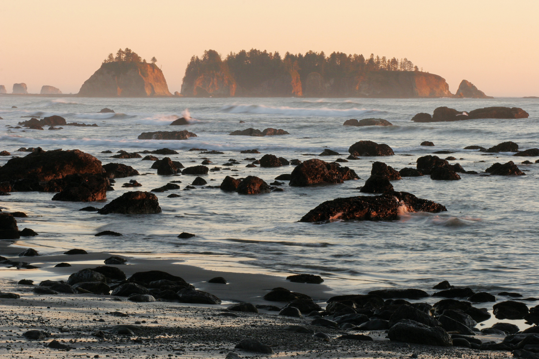
Olympic wilderness coast
Washington
Established June 29, 1938
922,651 acres
Olympic National Park earned widespread recognition (and international biosphere reserve status) because of its grand temperate rain forests—vast valleys of moss-laden forests filled with giant ancient trees and tumbling, crystal-clear rivers. Above the majestic emerald valleys stand glacier-covered peaks and jagged rocky ridges. West of the forested valleys runs a seemingly endless undeveloped stretch of wilderness beach.
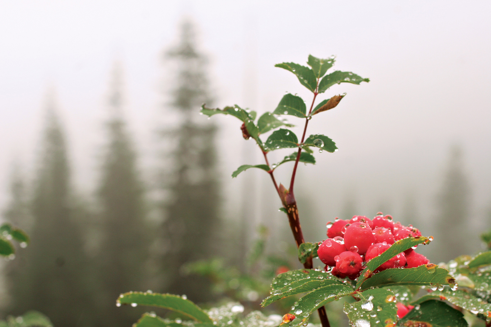
To experience the richest variety of life, you need to visit a rain forest. And when it comes to rain forest, North America trumps every other continent in the world. The planet’s greatest density of biomass (the total mass of organisms in a given area) is found in the temperate rain forests of Olympic National Park. The trees of the forest represent a large percentage of the equation. Indeed, the park’s huge conifers are some of the biggest living things on the planet. The cathedral forests of Sitka spruce, western hemlock, bigleaf maples, and western red cedar fill the river valleys on the west side of the main body of Olympic National Park, providing habitat for Roosevelt elk and black-tailed deer. The richness of these valleys boggles the imagination.
Moss coats just about every surface, and lichen drapes from nearly every limb. Trees grow to more than 250 feet tall and upward of 200 feet in circumference. These are trees that rival their famous California cousins, the redwoods and sequoias, in size and grandeur.
President Theodore Roosevelt protected the area as a national monument in 1909, and his distant cousin Franklin D. Roosevelt designated it as a national park 29 years later. The park gained an added level of protection and distinction late in the 20th century, when the United Nations recognized the unique nature of the park and designated it a World Heritage site in 1981.
For all its natural beauty, majestic forests, and rugged terrain, the park area was initially protected because of its elk. Theodore Roosevelt awarded the region its national monument status most of all because he wanted to ensure the protection of a species of elk found primarily in the rain forest valleys on the west side of the park.
By 1912, the elk population on the Olympic Peninsula had dwindled to fewer than 150 animals. The protections covered by the national monument and, later, national park designations, kept hunters from taking those last few animals.
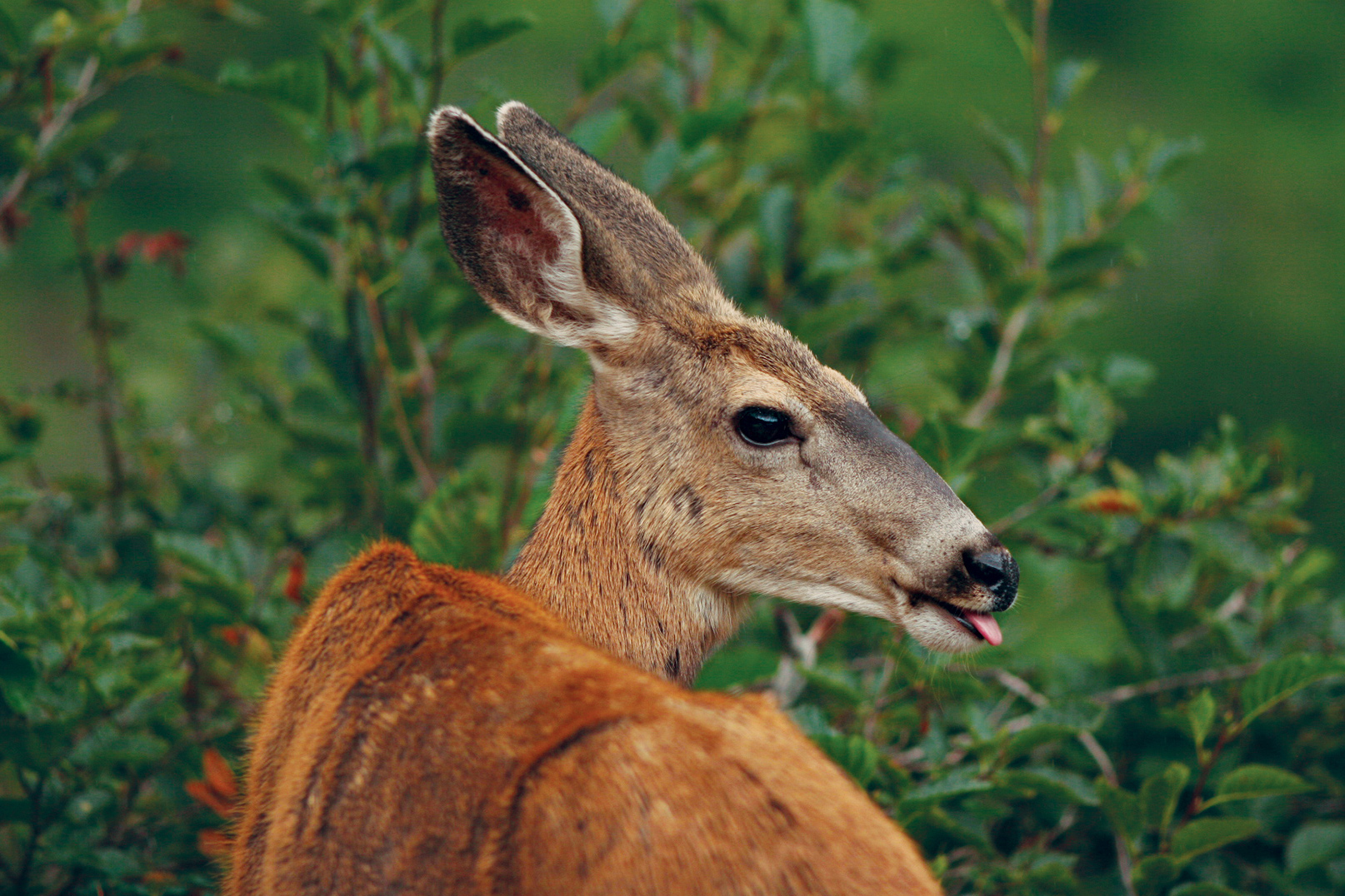
Today, the elk thrive and rightfully bear the name of their protector. Roosevelt elk are the largest species of elk in North America. In Olympic National Park, they have ready access to rich and plentiful food sources.
► HOW TO VISIT
This is a big park, and all the access roads are winding two-lane highways that can slow down travel times. Plan two days for a basic visit and at least a week for a more thorough exploration of Olympic.
For a basic park experience, head to Port Angeles and drive up to Hurricane Ridge. The 17-mile park road climbs steeply as it heads from near sea level to more than 5,000 feet in elevation.
Explore the verdant meadows and enjoy the stunning views—grand panoramas to the north encompass Canada’s Vancouver Island across the Strait of Juan de Fuca east to Mount Baker and the peaks of the North Cascades. To the south, the Olympic Mountains stretch across the horizon, highlighted by Mount Olympus and its gleaming glaciers. After a morning spent exploring the mountains, drive west on US 101 to Lake Crescent. Spend the afternoon hiking one of the many trails of the area.
On day two continue south on US 101 through Forks to the Hoh River Valley. Drive up the river road to explore the world-famous Hoh Rain Forest before continuing south to the coastal strand of beach. The park’s Kalaloch Lodge (a good option for an overnight) is close to the highway, with grand views of the wild Pacific Northwest coast. From Quinault, US 101 leads to Aberdeen. Turn east on US 12 to Elma, then northeast on Wash. 8 back to US 101 near Olympia. Take I-5 back to Seattle.

Hiking along Hurricane Ridge
Hurricane Ridge & the North Side
Towering over Port Angeles, Hurricane Ridge runs parallel to the Strait of Juan de Fuca. Thanks to the wonderfully scenic Hurricane Ridge Road, visitors can easily experience the panoramic views afforded by the open ridge. Looking south from the Hurricane Ridge summit, visitors see the park’s central wilderness and the glacier-covered summit of Mount Olympus. A short trail to the north provides views across the strait to Victoria, British Columbia, and the interior peaks of Canada’s Vancouver Island. To the northeast lie Mount Baker and the craggy peaks of North Cascades National Park, and to the southeast stands the sentinels of the eastern Olympics—Mount Deception, Mount Mystery, Mount Constance, and The Brothers, among others.
A mile and a half past the Hurricane Ridge Visitor Center, the road comes to an end at the base of Hurricane Hill. A gentle trail leads up the small grade, climbing through brilliant subalpine flower meadows. Going higher, the scenery becomes increasingly dramatic, with magnificent views of the interior Olympics and the valley carved by the mighty Elwha River coming into clearer view with each footstep.
The views from the summit, site of an old lookout, are grand, with wildflowers at your feet and the Olympic Range, dominated by Mount Olympus, just beyond reach, or so it would seem.
Explore the sprawling majesty of the ridge-top meadows before returning to Port Angeles and continuing west. Six miles from the park visitor center in Port Angeles, turn west onto Wash. 112 to access the Elwha River and the former site of the Elwha Dam. This is one of two dams removed by Olympic National Park in 2011 to restore the ecosystem of the Elwha River. By 2013, native salmon had already returned to the river, and for the first time in nearly a century, salmon spawned in the park’s section of the Elwha.
Back on US 101, drive west to Lake Crescent. The Marymere Falls Trail provides a leisurely 1.8-mile hike through forest to a slender ribbon of liquid beauty—the 90-foot Marymere Falls. About 10 miles past the Lake Crescent Lodge, leave US 101 by turning south on to Sol Duc River Road. The Sol Duc Falls Trail pierces a magnificent old-growth forest alongside the Sol Duc River.
The trail leads to one of the most scenic waterfalls—Sol Duc Falls—in the Olympic Mountains. This low, thundering cascade drops into a narrow gorge alongside the trail. The falls serve as a fine reward for the 2-mile hike.
East Side
US 101 runs north between Hood Canal and the park, providing access to the valleys that radiate out from the center of the park. The eastern half of the park receives less than a quarter of the rain totals on the west side of the park, or around 25 to 30 inches annually. As a result, you’ll find fewer ferns, less moss, and far more rhododendrons growing here.
Indeed, it’s not unusual to see enormous rhododendron bushes in this section of the park. These are bushes that can tower some 30 feet above the forest floor. Come spring, the forests turn vibrant pink as the rhododendrons explode into bloom.
Starting in Hoodsport, turn west off US 101 onto Wash. 119 to reach Lake Cushman and the Staircase Ranger Station at the end of the road. This scenic valley offers one of the best short hikes on the east side of the park, so take the time to amble along the 2.5-mile Staircase Rapids Loop for a gentle immersion into the rhododendron and fir forests of the area.
The route follows the south bank of stunningly clear North Fork Skokomish River before crossing a sturdy bridge at the head of the tumbling white-water rapids. Often spotted overhead here are kingfishers, bald eagles, and ospreys watching the river for prey.
The return portion of Staircase Rapids Loop goes through lush forest adjacent to the river and even delves into an old burn to provide a lesson in forest-fire renewal.
Back at Hoodsport, make your way north on US 101, past rivers that run through and out of the park. In this area are two of the primary valleys with park access, the Dosewallips and the Quilcene.
As US 101 approaches the northern edge of the Olympic Peninsula, it curves westward to Sequim and on to Port Angeles, where you’ll find the Olympic National Park Visitor Center, which is the headquarters for the park.
The Wet Side—Rain Forest & Beaches
The temperate rain forests of North America produce the largest accumulation of organic matter on Earth. In the park, the magnificent old-growth hemlocks, Sitka spruces, and red cedars contribute to that distinction. But the endless layers of moss, lichen, ferns, and other evergreen materials that blanket every surface, usually several feet deep, also make up a portion of the biomass total. All that greenery sprouts from rich soils fed by up to 150 inches of rainfall annually.
The most iconic temperate rain forest in the world is found south of the town of Forks, off US 101. The Hoh River Road leads up through the Hoh Rain Forest. For more than a drive can provide, hike the 17-mile Hoh River Trail at road’s end. The trail can be enjoyed whether you walk just a few hundred yards or hike up to the very shoulders of Mount Olympus. Regardless of the length of the adventure, the Hoh River Trail provides an unforgettable experience in a valley that plays host to massive old-growth western red cedar, Douglas fir, bigleaf maple, and Sitka spruce, all of which are draped with long, flowing beards of green.
Traveling south from the Hoh River, US 101 angles westward to brush against the edge of North America. At this corner of the park, the coastal strand stretches over 70 miles. It’s a wilderness landscape that starts at the mouth of the Queets River and runs north to the Makah Indian Reservation. US 101 follows 10 miles of this coastal access from Ruby Beach south to Kalaloch.
The word “beach” can be misleading. The beaches of the park’s coastal strand have nothing to do with white sand and turquoise water. Here, the Pacific Ocean pounds into the rocky edge of the continent, leaving cobblestone beaches and jagged headlands in its wake.
Just offshore rise an array of sea stacks—rocky remnants of the former coastline before the tides carved it. The rocky knobs rising from the surf tend to be popular hangouts for seabirds such as tufted puffins, as well as for marine mammals; seals and sea lions are commonly seen. Occasionally black bears venture down out of the coastal forests.
Though some of the park’s more remote sections provide the best wilderness experiences, they naturally can be hard to reach. To get a great taste of the park’s wild beaches and the powerful Pacific that grinds them down, make your way to Kalaloch beach, next to Kalaloch Lodge. The waterfront lodge provides overnight accommodations in the main building as well as a number of small cabins that dot the bluffs above the beach.
Northern Coast
Explorers with plenty of time may consider venturing west to Ozette. This remote park outpost offers grand adventures on the wild and scenic coast. The experiential highlight of this area is the 9-mile triangular Ozette Loop, which starts at the drive-in campground (one of 16 in the park).
The northern leg of the Ozette Loop angles west-northwest from the lakeshore, and for most of its 3-mile length, it is rustic boardwalk. (Be aware that these boardwalk planks can be slippery when wet—trekking poles and hiking shoes are highly recommended.)
At 3 miles, the trail gives way to the Pacific beach at Cape Alava, just south of the Ozette River. From the cobblestone strand it is 3 miles to Sand Point. Boardwalks cover much of the trail heading northeast, back to Lake Ozette.
Information 
|
How to Get There Few roads penetrate far into the massive park, but scenic highways encircle the park, providing good access for most of it. US 101 wraps around three sides of the park, with US 12 passing the park’s southern boundary. Visitors approach via the Bainbridge Island Ferry from downtown Seattle, or across the Tacoma Narrows Bridge from Tacoma. When to Go The park offers great activities year-round. Hurricane Ridge sports multiple hiking trails and during the winter, scenic snowshoe routes and even a small rope-tow ski area. In the west-side rain forests, it can rain at any time. Headquarters 600 E. Park Ave. |
Camping Olympic National Park operates 16 drive-in campgrounds, first come, first served, except Kalaloch Campground and the group site at Sol Duc. To reserve, 360-962-2271. Backcountry permits are available from visitor and information centers, ranger stations, and online. Lodging Within the Park lodging is available at: Kalaloch Lodge (thekalalochlodge.com; 360-962-2271), Lake Crescent Lodge (olympicnationalparks.com; 360-928-3211), Sol Duc Hot Springs Resort (olympicnationalparks.com; 360-327-3583), Log Cabin Resort (olympicnationalparks.com; 360-928-3325), and Lake Quinault Lodge (olympicnationalparks.com; 360-288-2900). For a list of neighboring communites with accomodations check: nps.gov/olym/planyourvisit/lodging.htm. Visitor Centers The main Olympic National Park Visitor Center is in Port Angeles. |
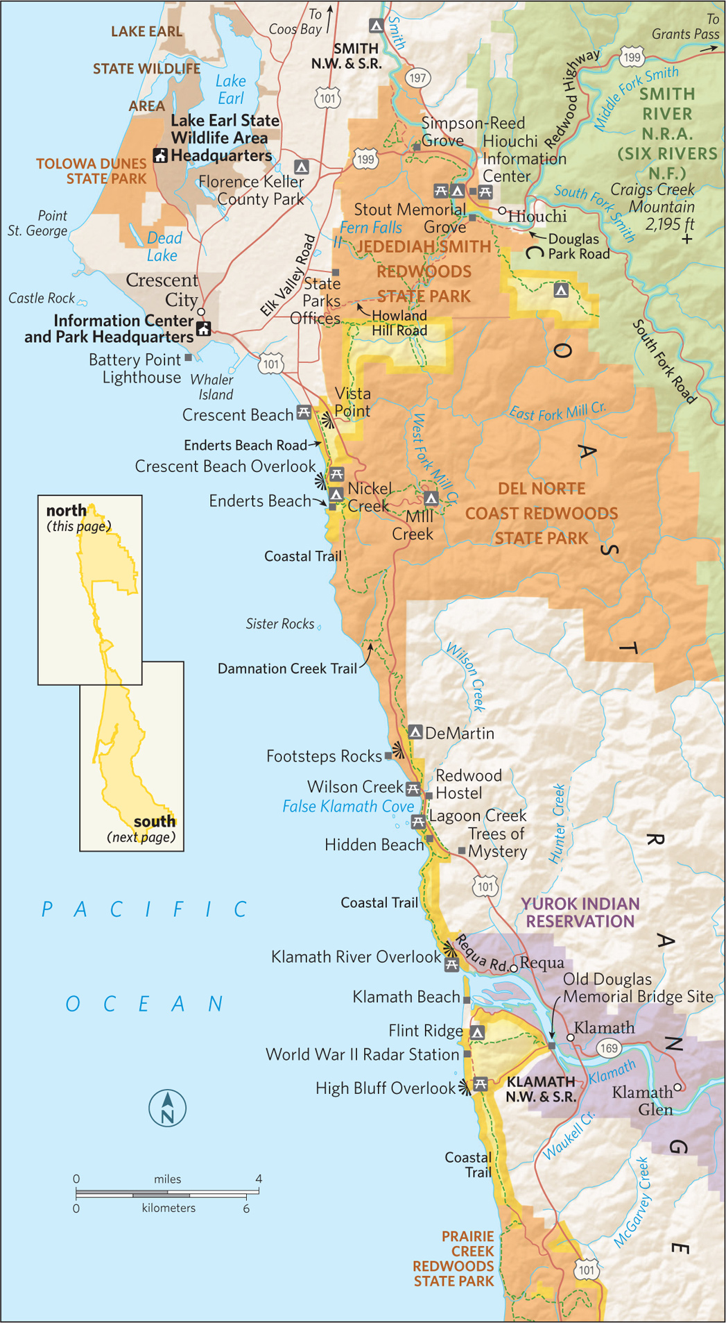
Foothill Trail, Prairie Creek in the Redwood National Park
California
Established October 2, 1968
131,983 acres; includes state parks
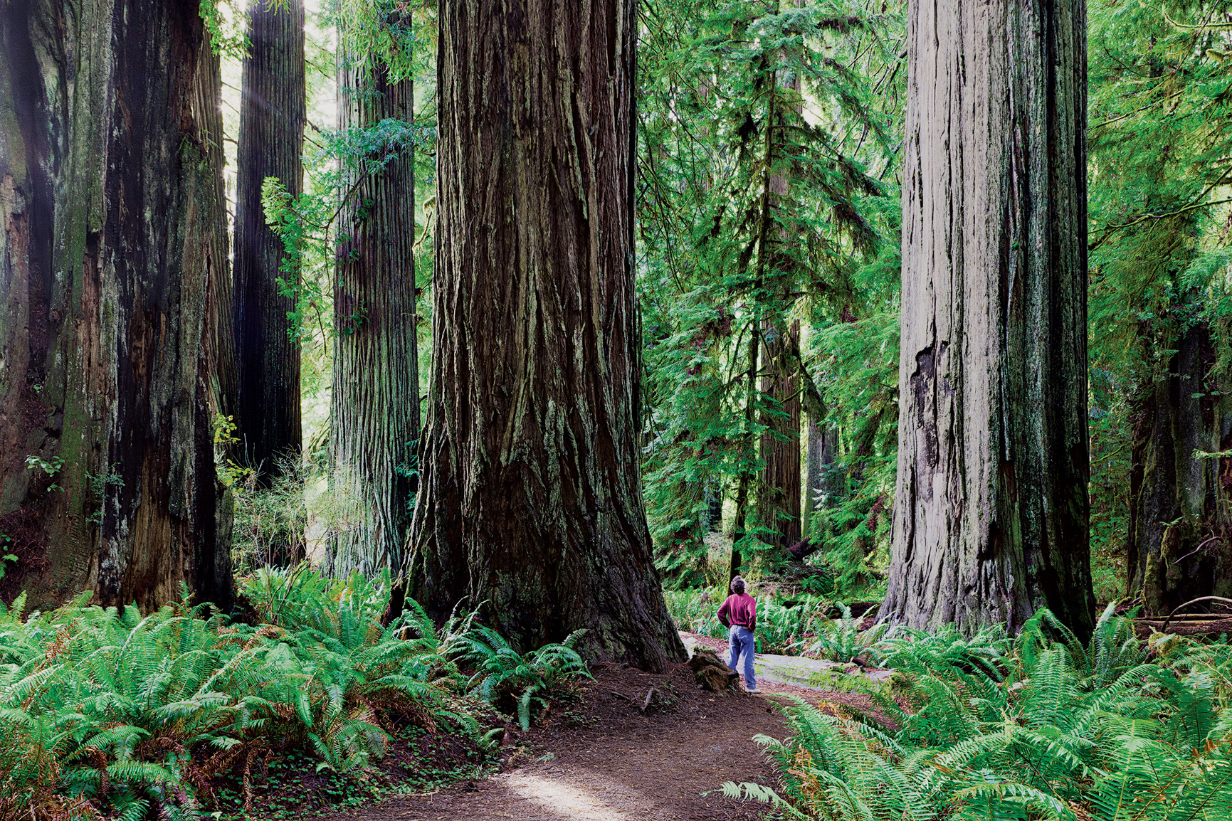
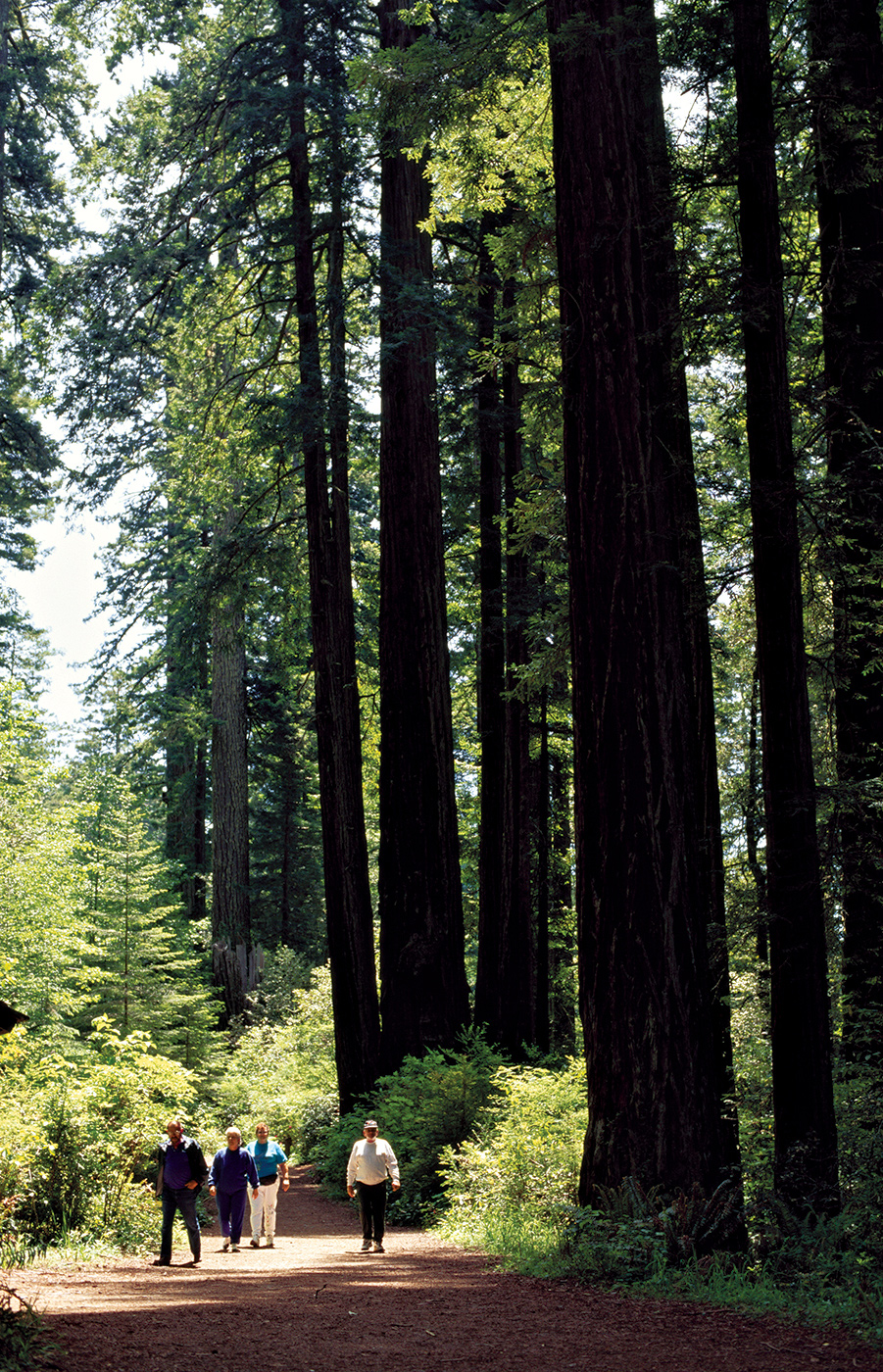
The world’s tallest known trees stand in the redwood forests of the northern California coast. Redwoods National Park blends federal and state lands into a harmonious ode to grandeur. While giant trees get top billing, Redwood is much more than supersize flora. The park also protects 37 miles of pristine Pacific coast, wild rivers and streams, rich wildlife populations, and relics of pioneer days.
Few national park areas have stirred such controversy as Redwood. The park was born of a long and sometimes violent struggle to save big trees from industrial logging—and the region as a whole from environmental devastation. The battle began shortly after World War I, when members of such organizations as the Save-the-Redwoods League realized that some of the world’s tallest living things were quickly disappearing. Combining private donations and state funds, the league purchased tracts of redwood forest that during the 1920s became Prairie Creek State Park, Del Norte Coast State Park, and Jedediah Smith State Park.
Conflict started up again in the 1960s when clear-cut logging in the region reached fever pitch. Discovery of the world’s tallest known tree in the threatened Tall Trees Grove by a National Geographic Society team expedited the call for federal protection. With powerful allies such as the Sierra Club and Lady Bird Johnson, the campaign finally resulted in the creation of Redwood National Park.
Land was added a decade later—including the groves with the tallest trees. In 1994, the National Park Service and the California Department of Parks and Recreation signed an agreement to manage the three redwood state parks and the national park cooperatively.
The number of people visiting the cathedral-like groves has expanded from fewer than 40,000 a year when Redwoods was first created to more than 800,000 today. They come to gawk at trees that, at more than 350 feet in height, would tower over the Statue of Liberty.
► HOW TO VISIT
Although US 101 runs through the heart of the park, the highway provides nothing more than a fleeting glimpse of the forest giants. Closer inspection requires leisurely drives down side roads or discovering forest trails on foot. Just outside the town of Orick, the park’s Redwood Creek section is accessible via Bald Hills Road. Although their exact location is a well-guarded secret, some of the world’s tallest known trees thrive in this drainage area. Prairie Creek lies at the heart of the park, a large meadow surrounded by trails through redwood forest or down Fern Canyon to gorgeous Gold Bluffs Beach. The park continues on the north side of the Klamath River in the form of Del Norte Coast Redwoods and Jedediah Smith Redwoods State Parks.
Nearly flat roads lend themselves to casual biking, and there are eight backcountry cycling routes. One can also explore the groves on horseback, or paddle Smith River and the lagoons via kayak or canoe.
Redwood Creek
Sixteen miles north of Trinidad, past Patrick’s Point, the coast highway meanders around the Humboldt Lagoons and into the national and state parks just before the turnoff to Thomas H. Kuchel Visitor Center. Kuchel is a great place to get maps, brochures, and the scoop on daily ranger-led activities.
Many of the guides and outfitters for the park’s southern region are based in Orick (2 miles away), an old logging town with a frontier feel. A jumping-off point for horseback trips into the park, Orick hosts a rodeo in July.
The wooded valleys and ridges east of Orick, along Redwood Creek, harbor the world’s tallest known living things, including a record-holding 380-foot-tall (and growing) beauty whose exact location is known only to a handful of people (see “Big Tree Hunters,” right). Scattered along Redwood Creek is the old-growth forest included in the original national park boundaries. Around this core are areas that were clear-cut prior to their addition to the park in 1978. An ambitious restoration program has revitalized this once devastated landscape.
Bald Hills Road, which starts 1 mile north of Orick, meanders through both the old-growth and restored parts of the Redwood Creek watershed. The road climbs to Lady Bird Johnson Grove, where the First Lady dedicated the national park in 1968. Continuing on, you’ll reach the Redwood Creek Overlook, with views to the Pacific.
Just beyond the overlook is the turnoff for Tall Trees Access Road, which leads to a fabled redwood grove of the same name. Access to this road is by permit only (you need a combination for the locked gate), available for free at the Kuchel Visitor Center and the Crescent City and Hiouchi information centers. Only 50 permits are issued each day, on a first-come, first-served basis. If you can secure a pass, drive the twisting dirt road all the way down to the parking area for the Tall Trees Trail and set off on foot. You’ll see plants that sprouted around the time that Rome’s Colosseum was under construction. It was in this grove in 1963 that National Geographic Society naturalist Dr. Paul Zahl discovered a Sequoia sempervirens measuring 367.8 feet in height—a world record at the time and one of the sparks for national park status.
Continuing up Bald Hills Road you’ll see the landscape go from redwood forest to a mosaic of Oregon white oak woodlands and broad meadows (prairies) spangled with wildflowers in the spring. At the southernmost reach of the park, you can hike a 2-mile trail to the historic Lyons Ranch, with pioneer-era barns, a bunkhouse, and a cemetery—remains of a 19th-century sheep farm. Old roads wind to the top of nearby Schoolhouse Peak, highest point in the park (3,097 feet) and an excellent perch from which to gaze down the valley to the Pacific Ocean.
Walking a redwoods trail
Six miles north of Orick is the turnoff from US 101 to the Newton B. Drury Scenic Parkway, which leads into Prairie Creek Redwoods State Park.The “prairie” is the vast meadow amid the redwoods where Roosevelt elk often graze. A small state park visitor center is located on the north side of the grassland. Nearby, the 0.3-mile Revelation Trail provides a powerful example of a redwood forest. Some of Prairie Creek’s largest and most majestic trees are found along the 2.2-mile Foothill Trail, between the visitor center and Cal–Barrel Road.
A 4.5-mile trail winds down to lush Fern Canyon, a deeply eroded gorge flanked by a “hanging wall” of ferns and slender waterfalls. The canyon’s antediluvian feel made it a movie star. Steven Spielberg filmed parts of The Lost World: Jurassic Park in the gorge, which also appeared in the BBC series Walking with Dinosaurs. You can follow the canyon’s meandering stream down to Gold Bluffs Beach. Heavy surf and cold temperatures make swimming iffy, but the beach is a great place to picnic and listen to seabirds.
Heading north from the prairie, Newton B. Drury Scenic Parkway runs 8 miles past old-growth redwoods before intersecting with US 101. Along the way are legendary giants like Big Tree (23.7 feet in diameter). Numerous trailheads start from the parkway, including the 1.8-mile Ossagon Trail, which leads to a secluded beach, where the huge rocks can be used for bouldering. Past its confluence with the parkway, US 101 descends into the Klamath River Valley, homeland of the Yurok people, California’s largest Native American tribe. Their reservation, 1 mile on either side of the river, stretches 43 miles inland. Just before the bridge is a turnoff for the Coastal Drive Loop, a largely unpaved route to Klamath Beach and its World War II radar station, disguised as a farmhouse and barn.
North of the Klamath
After crossing the river and skirting around Klamath town, turn left onto Requa Road and follow the signs 2 miles to the Klamath River Overlook. Perched at more than 600 feet, the bluff affords a dramatic view of the estuary and ocean, with the possibility of spotting migrating whales and sea lions far below. Three miles up US 101 from Requa junction is Trees of Mystery, a historic roadside attraction founded in 1931. The privately owned park is renowned for its Sky Trail cable-car ride through the redwood canopy and giant chainsaw sculptures, relics of redwood tourism of yore. Continuing to the coast, the highway passes a series of scenic stops including Lagoon Creek, where the short Yurok Loop Trail affords vistas of sea stacks and coastal bird colonies.
Beyond False Klamath Cove, the highway enters Del Norte Coast Redwoods. Look for a pullout at Mile 16, start of the spectacular Damnation Creek Trail, which descends 1,100 feet to a secluded rocky beach. Eight miles farther north is a turnoff to the lovely beaches and tidepools along Enderts Beach Road.
Most visitors take US 101 through Crescent City to reach Jedediah Smith Redwoods State Park, named for explorer and trapper Jedediah Smith, who in 1828 became the first non-native to walk amid the giants. Those who prefer the road less traveled can cruise Howland Hill Road, a rugged route that runs through an old-growth forest called the National Tribute Grove, dedicated to Americans who fought in World War II. Several trails start here. One trail loops through Stout Memorial Grove. In 1929, soaring Stout Grove became one of the first stands of coastal redwoods set aside for protection when a 44-acre parcel was donated to the California state park system by the widow of lumber baron Frank D. Stout. Its riverside location and the way late-afternoon sun filters through make the grove a favorite.
The Smith River flows through the state park, warm enough between June and August to entice rafters, paddlers, and swimmers. There are plenty of spots for fishing, too—cutthroat trout in the summer and salmon or steelhead during the fall and winter. A footbridge over the river links Stout Grove with the Jed Smith campground. Tucked among the campsites, the Jedediah Smith Visitor Center offers information, exhibits, and interpretive programs. US 199 leads back to the coast through another redwood-rich area that includes the Simpson Reed Grove and other big tree stands.
Information 
|
How to Get There From San Francisco, CA (about 310 miles south), take US 101 north via Santa Rosa and Eureka. Or take Calif. 299 from Redding, CA; US 199 from Grants Pass, OR; and US 101 from Coos Bay, OR. When to Go Redwood is open year-round, but has crowded trails and bumper-to-bumper roadways during summer season. Spring is great for wildflowers, autumn for chromatic leaves, while winter is cool and rainy but redwood groves are less crowded. Visitor Centers Thomas H. Kuchel Visitor Center, off US 101, south of Orick, CA; open year-round. Both Prairie Creek Visitor Center, off US 101 north of Orick, and Jedediah Smith Visitor Center, off US 199, northeast of Crescent City, CA, open summer only. |
Headquarters 1111 Second St. Camping Three national park campgrounds—Jedediah Smith (86 sites), Mill Creek (145 sites), and Elk Prairie (75 sites)—accept reservations (reserveamerica.com; 800-444-7275). Gold Bluffs Beach (26 sites) is first come, first served. Backcountry camping requires a free permit, available from the Thomas H. Kuchel Visitor Center. Lodging No overnight lodging inside the park, but there are plenty of choices in nearby communities. Check out nps.gov/redw/planyourvisit/lodging.htm. |