 From US 60 West in Buckingham County, turn right onto VA 605 (River Road). Travel 7 miles, then turn left onto VA 606 (Park Road) and immediately enter the park. GPS: N37 37.410’ / W78 48.512’. DeLorme: Virginia Atlas & Gazetteer: Page 55, C5.
WHY GO?
Set in bucolic Buckingham County, the 1,500-acre James River State Park perches on 3 miles of riverside property that has cultural roots reaching back to pre-Revolution times and one of Virginia’s most influential families. Trails range from flat paths along the James to pitchy routes through the young pine and hardwood forests on the valley hillsides. Equestrians are some of the park’s heaviest users, but 15 miles of trails that span both river and forest habitats offer hikers a lesson in how a small park can still deliver big rewards.
THE RUNDOWN
Start: Grass parking area on the park road between the ranger contact station and nature center
Distance: 7.5-mile loop
Hiking time: About 3.5 hours.
Difficulty: Moderate due to length and pitchy terrain along woodland paths
Trail surface: Grass and dirt paths
Land status: State park
Nearest town: Bent Creek, VA
Other trail users: Equestrians and hunters (in season)
Accessibility: The 0.25-mile Green Hill Pond Loop is a paved trail with boardwalks over a scenic fishing pond featuring a universally accessible fishing pier.
Canine compatibility: Leashed dogs permitted
Trail contact: James River State Park, 104 Green Hill Dr., Gladstone; (434) 933-4355; www.dcr.virginia.gov/state_parks/jam.shtml
Schedule: Open daily, dawn to dusk. The park is closed for hunts for a few weeks in Nov and Dec.
Fees/permits: Day-use fee
Facilities/features: Canoe rentals, visitor center, and camping
NatGeo TOPO! map: Shipman, Gladstone
Other maps: Hand-drawn map of trail system available at park
FINDING THE TRAILHEAD
From US 60 West in Buckingham County, turn right onto VA 605 (River Road). Travel 7 miles, then turn left onto VA 606 (Park Road) and immediately enter the park. GPS: N37 37.410’ / W78 48.512’. DeLorme: Virginia Atlas & Gazetteer: Page 55, C5.
THE HIKE
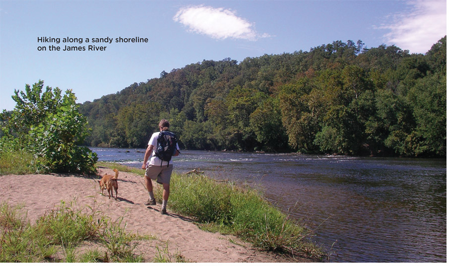
A beautiful confluence of summertime sounds rises up from and around the James River as it sweeps around a lazy river bend. Water rushes over river rocks with a constant shooshing. Cicadas buzz and clatter in the tall riverside grass. Birdsong floats down from the broad sycamore and willow trees. It is a natural orchestra.
The mighty James River lends the park its name, but it is only one feature among many that make this a special place. Fields in the bottomland and forests on riverside slopes show a vigorous rebound from centuries of farming and logging. Skinny trunks amid the oaks and hickory and pine trees mark this as a young, growing forest. But they still provide welcome shade and the occasional wildlife sighting—a fox sighting along the Branch Trail wouldn’t be surprising. Fields along the river’s floodplain show telltale signs of old field succession, where pine saplings indicate a natural process that, if left untouched, would result in a mature hardwood forest. Other fields are kept mowed, while the high grass that lines trails through the river bottomland explodes with the bright yellows of golden ragwort and the purple of paintbrush.
Equal to the natural beauty is the impact of humans on the landscape. Ownership dates back to colonial Virginia and the Cabell family, who owned land throughout the Piedmont region. Land that is now state park was part of a larger estate called Green Hill, given in 1726 to Colonel John Cabell as a wedding present from his father.
Farming was the subsidence of the Cabell family, but they also cast an eye out onto the James River and farther west. A farmer prospers when his goods can make it to market. For that purpose, the James served farmers well, but only seasonally. It could be too shallow to navigate in the hot summer and autumn months, and too volatile, subject to raging floods in winter and spring. Many believed the answer was a system of canals that would skirt the troublesome sections of the river and control its flow. Generations of Cabells threw themselves into developing the James River and Kanawha Canal system with the hope of linking eastern seaports with farms in the Ohio Valley and beyond. Started in 1785, it was only half completed to the Kanawha River by 1851. It ultimately stalled near Clifton Forge, Virginia, on the eve of the Civil War. That conflict and the rise of the “Iron Horse” locomotive doomed the concept of river-and-canal systems along the James.
The war also marked the end of the Cabell family’s relationship to the land. In the 1870s this property was bought by the Dickens family, who owned it until purchase by the Commonwealth of Virginia in 1992—in total, nearly 300 years of ownership by only two families. The park opened in 1999.
The deep history is only one reason to appreciate a day spent hiking trails that span the river bottomland and wooded hills of James River State Park. Like old fields that grow to forest and rivers that flow to the sea, time marches on.
MILES AND DIRECTIONS
0.0Start at a grass parking lot and trail board on Park Road between Canoe Landing Road and the cabin loop road. Turn south, cross Park Road, and enter woods opposite on a yellow-blazed trail. Within 20 feet, veer right at a fork, staying on the wide mowed path.
0.1Stay straight and avoid the trail that splits left into the woods. You are now on Running Creek Trail, a rocky footpath.
0.2At a fork veer left as Running Creek climbs through a young hardwood forest of oak, hickory, maple, and beech via switchbacks. Note: The right fork at this junction is part of the Cabin Loop Trail.
0.3Cross paved Canoe Landing Road.
0.5Reach a T junction and turn right on River Trail. Note: The trail on the left is the return portion of this loop hike.
1.0As you descend off a hill toward a clearing, stay alert and veer right, cross two wooden footbridges, and emerge into the clearing at a trail board. Cross a dirt and gravel road and follow a grass trail downhill. The Canoe Livery is downhill on your left.
2.0River Trail takes a hard right (east) to follow a jog around a small tributary before returning to the river’s edge.
2.1Take a moment to enjoy the James River: A footpath leads left to water’s edge and a small sandbar perfect for a snack break.
2.6The River Trail makes a sharp right and turns away from the river.
2.8Veer left, cross a footbridge, and pass through a gate. Reach a gravel road and turn right, uphill, to access Cabell Trail. Within 0.1 mile, bear left onto Cabell Trail, which here is a mowed grass path.
3.1Cross over the gravel Green Hill Pond access road and continue uphill on the orange-blazed Cabell Trail. At the crest of the hill, turn left and cross the park road. Cabell Trail climbs uphill as a wide dirt and gravel service road. Note: At this junction, there is a trail board with a map and several large sycamore trees that provide good shade for a midday break, as well as a park picnic area, restrooms, and a visitor center.
3.4Continue straight past the Dixon Landing Overlook Trail on the left.
3.8Turn left to access the Tye River Overlook. It is 0.1 mile to the wood platform with a view of the confluence of the Tye River into the James. Retrace your steps to the Cabell Trail and turn left to continue this route uphill.
4.2Turn right and uphill as Cabell Trail leaves the service road and enters a pine forest as a woodland footpath.
4.4Merge onto Branch Pond Connector Trail by staying straight at a trail junction where Cabell Trail turns right (east). Within 30 feet of this junction, swing left on an unmarked dirt path, avoiding a gravel road leading right, downhill, to a primitive camping area. Note: On state park trail maps, this left turn is labeled as Branch Pond Loop Connector.
4.6Wrap around the headwaters of Branch Pond, and at a junction soon after, turn right to follow the Branch Pond Loop Trail.
5.0Enter the Branch Pond Picnic Area. Stay alert and turn left on Branch Trail before you reach the gravel parking lot, restrooms, and picnic area.
6.2Turn left and descend to the park road. The ranger contact station is visible uphill on the left. Cross and follow a short connector to Running Creek Trail.
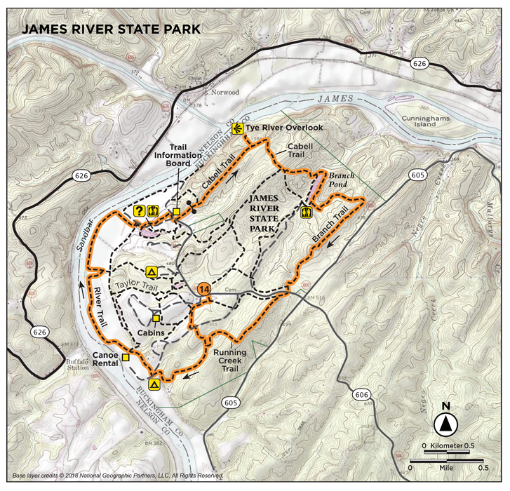
6.4At a four-way junction. Here Running Creek Trail is a wide mowed path blazed yellow.
7.1Turn right and continue on Running Creek Trail. Note: The trail straight from this junction is the River Trail that leads to the James River and Canoe Livery.
7.2Cross Canoe Landing Road.
7.3Veer right onto Running Creek Trail.
7.5Arrive back at the parking lot.
HIKE INFORMATION
LOCAL INFORMATION
Appomattox Visitor Information Center, 214 Main St., Appomattox; (434) 352-8999; www.historicappomattox.com. Located in a historic train depot.
LOCAL EVENTS/ATTRACTIONS
The James River Raft Race and Summer Festival takes place in the park each July.
Appomattox Court Hovuse National Historical Park, Appomattox, (434) 352-8987, www.nps.gov/apco. Park preserves the site where General Robert E. Lee surrendered to General Ulysses S. Grant, an act that formally ended the Civil War. Walking tours, interpreters, and special events commemorate this small village’s big role in the war.

LODGING
The park features family lodges, cabins, a large full-service campground, horse camping, and primitive camping along the river. For reservations, call (800) 933-PARK or go to www.reserveamerica.com.
RESTAURANTS
There are grocery stores in Gladstone, but the nearest restaurants are in Appomattox (19 miles) and Amherst (22 miles).
ORGANIZATIONS
Friends of James River State Park, (434) 933-4355, www.virginiaparks.org/friends-jr