18. ROCKY MOUNT/GAP RUN
WHY GO?
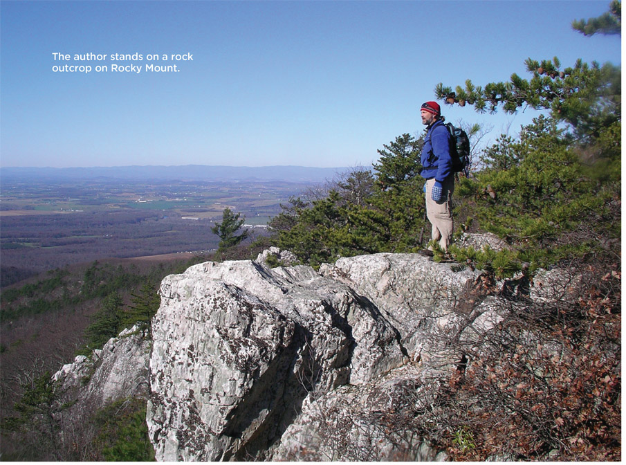
Rocky Mount’s western flank is a demanding climb of 850 feet in just over 1 mile. If you’re not breathless at the top, the view will steal what breath is left. A series of ridges and peaks intersect and rise in succession to the limitless horizon. A return hike on Gap Run Trail takes you from soaring heights into shaded forest. It’s said trails in the south district of Shenandoah National Park get less use than other areas of the park. The Rocky Mount/Gap Run loop is proof of this. As a day hike, it is a strenuous full-day trip. Overnighters will find that a quiet tent site along Gap Run allows time to tarry and enjoy the deep-woods scenery.
THE RUNDOWN
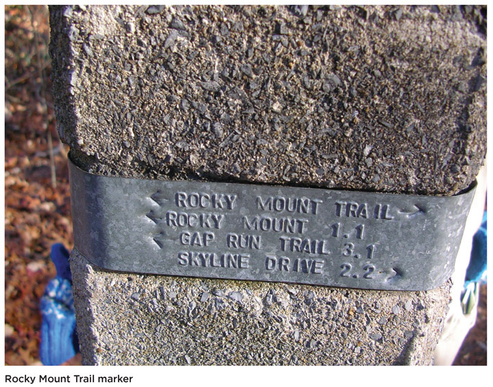
Start: Concrete post on the west, or southbound, side of Skyline Drive, 0.1 mile north of Twomile Run Overlook
Distance: 10.1-mile lollipop
Hiking time: About 7 hours
Difficulty: Moderate due to a steep climb up Rocky Mount
Trail surface: Make your way along dirt and grass footpaths, rock slides, high-water washes, old streambeds, and rock outcrops on Rocky Mount to the old-growth chestnut oak forests and the dark, sheltered stream valley.
Land status: National park
Nearest town: Elkton, VA
Other trail users: Hikers only
Accessibility: This trail is not accessible to people with disabilities; however, most of the facilities within the park are. Check out the accessible 1.3-mile Limberlost Trail (Mile 43).
Canine compatibility: Leashed dogs permitted (leash no longer than 6 feet)
Trail contact: Shenandoah National Park, 3655 US 211 East, Luray; (540) 999-3500; www.nps.gov/shen
Schedule: Open year-round. Skyline Drive may close without advance warning due to inclement weather. Even when Skyline Drive is closed, hikers may still enter the park on foot. Most facilities begin opening in Mar and close by late Nov.
Fees/permits: Entrance fee required, valid for 7 days, or annual pass. Backcountry camping permits, available at ranger stations and visitor centers between sunrise and 1 hour before sunset, are required. Campfires prohibited except in established fireplaces. Before visiting, review backcountry regulations, which cover such issues as group size, where to camp, and waste disposal. Call (540) 999-3500 for regulations. To fish in Shenandoah National Park (SNP), Virginia residents age 16 or older must have a Virginia state fishing license.
Facilities/features: The park offers visitor centers, wayside pull-offs, dining, and lodging.
NatGeo TOPO! map: McGaheysville
NatGeo Trails Illustrated map: Shenandoah National Park; Appalachian Trail, Calf Mountain to Raven Rock
Other maps: PATC #11: Shenandoah National Park South District
FINDING THE TRAILHEAD
 From the south, take exit 99 off 1-64 and proceed north on Skyline Drive for 28 miles. Twomile Overlook is at Mile 76.2, on the west side of Skyline Drive. From the north, access Skyline Drive from US 33 in Swift Gap. Drive south on Skyline Drive for 11 miles to reach Twomile Overlook on the west side of the highway. From the overlook, walk 0.1 mile north along the west shoulder of Skyline Drive to reach the Rocky Gap Trailhead, marked by a concrete post. GPS: N38 17.944’ / W78 38.826’. DeLorme: Virginia Atlas & Gazetteer: Page 67, B6.
THE HIKE
Gap Run can be a monster. That much was clear from tree limbs and other forest debris scattered across its floodplain. Rocks larger than a human head lay piled around the base of larger trees, some 20 feet removed from the actual stream bank. Thinking of the torrent that moved them made me reconsider the small, puddling, barely moving flow that trickled past my campsite. You see, in late July, Gap Run is anything but a monster: a puddle here and a puddle there, and not much else.
A few feet upstream, my nephew, Matthias, took advantage of summer’s low-water conditions to scramble over streambed rocks in search of a crayfish or salamander. I had gone over with him proper streambed hunting techniques: Squat or hunch down on a rock, I said, and just stare at one spot in the stream. Then slowly, with two fingers, lift one stone at a time. Give the silt time to settle, then, if you don’t see what you’re looking for, replace the stone where you found it. A lot of critters call this stream their home, I said. And no one likes to come home and find his house rearranged.
These are the good times, I thought as I watched him explore. A few hours earlier, it was all about adjusting packs, lightening loads, tending to blisters and hot spots, and helping a struggling 7-year-old come to terms with carrying his food, water, and clothing for miles on end, all so we could sit in the woods, eat prepackaged food, and sleep on hard ground.
Leadership training, whether for business or wilderness adventure, preaches the importance of monitoring your group’s morale. A happy camper interacts better with others and is more willing to help the group. With children, this is especially true. There usually comes a time, a critical moment—almost always after a difficult stretch of trail—when an uncomfortable thought settles in: This, they state plainly, is too much like work.
Our group—Mary, myself, and our niece and nephew, Sarah and Matthias—began the hike off Skyline Drive on Rocky Mount Trail. It started nicely on a dirt footpath that posed little risk of injury, on a gentle slope with sporadic views southwest to Twomile Ridge. When the trail steepened and curved around the east side of a small knob, legs weakened. Complaints started drifting back my way and I heard someone say they were dizzy. All indicators pointed to a much-needed rest. The opportunity presented itself once the trail reentered the shade of forest.
Every leader needs a bag of tricks and the next 2 miles exhausted my personal stash. We played “Trail-Wheel of Fortune.” We set group challenges to hike a certain distance in a certain period of time. We sang songs. Every time a view opened on the trail, I used it as a topographic lesson by pointing out where we stood. We juggled loads, adjusted shoulder straps, medicated sore feet, and, before long, we hit a nice campsite on the Gap Run Trail. Three miles in 6 hours—the pace left a little to be desired, but a successful first day by all other measures.
Sigurd Olson, author of Campfires, wrote “anyone who has traveled in the wilds knows how much he looks forward to the time of day when he can lay down his burden and make camp.” I’m not sure Olson ever hiked with children, because for them, camp means one thing: Work. Unpack your backpack. Help set up tents. Prep dinner. Get firewood. Get water. Then a chorus of don’ts: Don’t go in the tent with shoes. Don’t throw dirt at your sister. Don’t touch that plant. Don’t eat that bug . . .
At this delicate point, when commands are flying fast, it pays to remember: The poor kids have already completed a herculean task just getting here. More importantly, if their needs aren’t met, they can hardly be expected to meet someone else’s.
With imagination, jobs can be fun. Matthias and I drew water duty, which led us to search Gap Run for some running water, which in turn led to not getting water at all. Instead, we moved up and down the dry wash, checking out small pools for aqua-critters. A snap-crackle brought us to the shoreline where, in dry oak leaves, a turtle the size of a half-dollar pumped tiny legs in a vain attempt to escape detection. We tracked it for 10 minutes or so, until I remembered that without water, we wouldn’t eat. We filtered and headed back to camp.
Anticipation motivates. Over breakfast the next morning, Mary and I announced the day hike would be without packs. That prospect sent Matthias and Sarah up the trail like shots. When we caught up, their flushed faces and panting told the story: It’s hard to keep an excited kid down, but it’s also difficult to run up Rocky Mount. As we approached the white outcrops of the summit, I told the kids to be on the watch. The Erwinian quartzite is pocked with small fossil wormholes that date from a period when this incredibly hard rock was the beach of a prehistoric ocean. As amazing as that sounds, I witnessed something even more mind-boggling: two kids running uphill the last tenth of a mile, each trying to be the first to the summit.
Atop Rocky Mount, we stared across to Rocky Mountain and Twomile Ridge, each of us alone in our thoughts. Turkey vultures rode air currents, wings shifting to-and-fro as they held a tricky balance of speed and direction. “This,” said 11-year-old Sarah, “is the most awesome thing I’ve ever seen in my entire life.”
MILES AND DIRECTIONS
0.0Start at the Rocky Mount trailhead 0.1 mile north of Twomile Run Overlook on Skyline Drive.
0.6The trail climbs briefly, then drops to an easy stretch along a footpath. Note: The trail shows signs of once being a road. In fact, this route once served as a fire road up from Berrytown, a town at the foot of the Blue Ridge west of Rocky Mount. Occasional views open west to Twomile Ridge and east into the Hawksbill Creek valley and Weaver Mountain.
1.0Hike along an exposed stretch of trail as you make a brief, 200-foot climb up over a small knob. The trail reenters the woods as it descends the northwest side of this hill.
2.2Come to the intersection of Gap Run Trail and Rocky Mount Trail. Continue straight to climb Rocky Mount. Note: Gap Run Trail heads off to the right and descends past the headwaters of Gap Run. It junctions with the opposite end of Rocky Mount Trail in 2.2 miles.
2.5Begin a steep climb up Rocky Mount. Views of Twomile Ridge open up when the trail switches back to the right.
2.9Exposed chunks of chalky rock become more frequent. Close examination reveals fossilized wormholes in this Erwin quartzite.
3.2About 40 yards shy of the wooded peak on Rocky Mount are cliffs with views of Twomile Ridge, and six ridges rising in succession beyond. Note: There is rocktripe lichen on the rocks at this summit. It appears brown, with folded-up edges, and is brittle to the touch. The Audubon field guide describes this lichen as “rarely seen,” so take a minute to enjoy.
3.8A large slab of rock becomes increasingly visible on the left side of the trail as you descend. Old-growth chestnut oaks line the trail on your right, and the forest understory is a mix of blueberries, sassafras, and scrub oak. (The sassafras has quite a history. Explorers and colonists treated it as a cure-all. It shrinks less than any southern hardwood, thus was favored in building fences and boats, but its odor supposedly drove away bedbugs, which made it a favored wood for building a bed frame. It was once used widely as a flavor agent. Lately, scientists have found that safrole, a clear oil found in the roots of sassafras, is a cancer-causing agent. Its use in food and drinks is forbidden in the United States.)
4.7Cross the first of several rock slides that have covered the mountain below and above the trail with boulders. (Be careful when crossing the rock slides. There is no danger of further slippage, but footing is tricky.) After this the trail descends via switchbacks to a small tributary of Gap Run.
5.1Cross a small stream and follow the right bank downhill. Within several hundred yards, you’ll hop back across the stream and follow the left bank. The trail is clear; stream crossings are well marked.
5.5Cross Gap Run and reach a T intersection where Rocky Mount Trail meets Gap Run Trail. Turn right onto Gap Run Trail. Note: To the left, Gap Run departs the park in 0.8 mile and reaches VA 630 near Berrytown in 1.7 miles.
5.7An open area to the right of the trail marks an established primitive campsite.
6.2Gap Run Trail, which has followed the footprint of an old dirt road, becomes a footpath as it crosses a washed-out section of Gap Run. The stream forks into many small rivulets and the trail crosses them as it winds up the wide stream valley. In 0.1 mile, the trail reverts back to a wide, graded path.
6.4Veer right and continue walking upstream on a woodsy footpath. Note: The old road veers left and uphill. Red paint slashes on the trees mark the national park boundary.
6.6Cross Gap Run. As you climb up the stream valley for the next mile, you will cross the stream two more times.
7.6Cross Gap Run for the final time and begin a steep ascent to a saddle and the junction with Rocky Mount Trail.
7.9Gap Run Trail ends at Rocky Mount Trail. Turn left to return to Skyline Drive.
10.1Hike ends at Skyline Drive. Turn right and head downhill 0.1 mile to parking at Twomile Run Overlook.
HIKE INFORMATION
LOCAL INFORMATION
Town of Elkton, (540) 298-1951, www.elktonva.gov
LOCAL EVENTS/ATTRACTIONS
The Town of Stanardsville has specialty shops, lodging, and dining. www.stanardsville.org
LODGING
Park lodges at Skyland (Mile 41.7 and 42.5), Big Meadows (Mile 51.2), and cabins at Lewis Mountain (Mile 57.5) are seasonal. Call (877) 247-9261 or go to www.goshenandoah.com for reservations.
Campgrounds are located at Matthews Arm (Mile 22.2), Big Meadows (Mile 51), Lewis Mountain (Mile 57.2), and Loft Mountain (Mile 79.5). Some are first-come, first-served. For campground reservations, call (877) 444-6777 or visit www.recreation.gov.
Six backcountry cabins are operated by the PATC. For reservations, call (703) 2420693 or visit www.patc.net.
RESTAURANTS
Full-service restaurants are located at Big Meadows Lodge (Mile 51.2) and Skyland (Mile
41.7 and 42.5), and Wayside Food Stops at Elkwallow Wayside (Mile 24.1), Big Meadows Wayside (Mile 51.2), and Loft Mountain Wayside (Mile 79.5). All restaurants are seasonal. Visit www.goshenandoah.com for information.
HIKE TOURS
Ranger-guided programs are offered spring, summer, and fall.
For commercial tour operators that are permitted in the park, visit www.nps.gov/shen/planyourvisit/permitted-business-services.htm.
OTHER RESOURCES
Potomac Appalachian Trail Club (PATC), Vienna, (703) 242-0315, www.patc.net. Publishes maps and guides and sponsors hikes in the park.
Shenandoah National Park Association, Luray, (540) 999-3582, www.snpbooks.org. A nonprofit partner that sells guidebooks, maps, brochures, and CDs on the history, flora, and fauna of Shenandoah National Park, to benefit park activities.