24. FRIDLEY GAP
WHY GO?
Some days, you can hike for miles and feel like you never left the parking lot. Other times, it can feel like you walked through four different worlds in a single afternoon. Thankfully, you’ll find Fridley Gap fits the latter experience. Squeezed together accordion-like, the long, parallel ridges of First, Second, Third, and Fourth Mountains concentrate an awful lot of up-and-downs into a day of hiking, and, consequently, a number of different habitats. At the lower elevations, stream valleys attract deer to the water’s edge. Skinny rays of sunlight filter down to the forest floor through eastern hemlock. A half-mile away stands another world: the dry, barren ridgetops. With no tree cover, views stretch for miles. Two different worlds, one hike.
THE RUNDOWN
Start: Gate across FR 65
Distance: 9.4-mile double loop
Hiking time: About 5 hours
Difficulty: Moderate, with steep climbs up Third and Fourth Mountains
Trail surface: Dirt paths, old logging roads, and gravel forest roads wind along Fridley Run and rock outcrops along Fourth Mountain, and lead to a waterfall and swimming hole on Mountain Run.
Land status: National forest
Nearest town: Shenandoah, VA
Other trail users: Equestrians, mountain bikers, cross-country skiers, and hunters (in season)
Accessibility: None
Canine compatibility: Dogs permitted
Trail contact: Lee Ranger District, Edinburg; (540) 984-4101; www.fs.usda.gov/gwj
Schedule: Open year-round. Hunting is permitted in national forests, with deer season the busiest from Nov to early Jan.
Fees/permits: None
Facilities/features: None
NatGeo TOPO! map: Elkton West, Tenth Legion
NatGeo Trails Illustrated map: Shenandoah National Park; Massanutten and Great North Mountains
FINDING THE TRAILHEAD
 From Elkton, from the junction of Business 33 and VA 635 (River Road), drive north 3.3 miles on VA 635 and turn left (south) on VA 602 (East Point Road). Drive 1.0 mile, turn right onto VA 636 (Runkles Gap Road). In 2.2 miles, enter the George Washington National Forest. In 0.1 mile past the forest boundary, VA 636 ends, although the gravel road straight ahead continues as gated FR 65 (Cub Run Road). Pass a small parking area and go through a forest gate (park here if it is locked). In 0.2 mile, find the trailhead off the left side of the road. There is minimal parking here. GPS: N38 27.245’ / W78 41.825’. DeLorme: Virginia Atlas & Gazetteer: Page 67, A6.
THE HIKE
Oak trees have always fascinated people. Pagan worshipers likened the tree’s physical traits—tall, sturdy, and long-lived—with the most powerful gods. Zeus, the Greek god of thunder and lightning, considered the oak sacred. This, in turn, may have informed the old English saying “Beware the oak; it draws the stroke,” a reference to just how often oaks get struck by lightning.
Reverence for the oak seems justifiable given its usefulness. Ancient people treated it like a department superstore, a complete package, able to provide all the stuff for living. Acorns not only made food (acorn cakes), but also attracted the deer, bear, and small game that became food. Homes and furniture were built of oak boards. Oak logs provided fuel for heating and cooking. And while it’s true that Europeans looked down their noses at the North America white oak sent to them, the wood proved durable enough to construct the first ships for the US Navy.
Oaks, in their natural setting, define the forest type between southern New England and Georgia. Their presence sets the tone for how large or widespread other trees grow. Additionally, more than 200 known species live off the oak, from the squirrels that survive on its acorns to the mushrooms growing on its trunk. Elevation and soil conditions matter little; there’s a type of oak for every location. In the mountains, white oaks grow in stream valleys and on moist hillsides. Chinquapin and bear oak are found as thickets in the young second- or third-generation forests. Red oaks mix with the whites, the beeches, and the maples at low elevations, but emerge in pure stands at higher elevations. Chestnut oaks, so named for the leaf’s resemblance to that of the much-diminished American chestnut, take root on rocky hillsides and dry ridges.
Changes in elevation and moisture occur quickly over short distances in the Massanutten Mountain chain. This 55-mile-long grouping of ridges and knobs rises from the floor of the Shenandoah Valley in the shape of a needle, with forks of the Shenandoah River flowing along either flank. At its southern end—the point of the needle—stand the highest points, Lairds Knob (3,282 feet) and Massanutten Peak (2,922 feet). Here also stands Third Mountain, as well as its neighbors First, Second, and Fourth Mountains, all of them long, parallel ridges squeezed together like the folds of an accordion. For every wrinkle in this mountain landscape, there’s an oak tree to tell hikers about the soil conditions, climate, and annual rainfall. Leaf litter along the Massanutten South Trail shows telltale signs of white oak. Along this same trail, a mile past Boone Run, red oaks replace white as the dominant tree along the descending ridge of Fourth Mountain. (Hikers should be able to distinguish between the two most abundant oaks—red and white. The leaf of a white oak has rounded tips between the deep lobes; a red oak leaf has pointed or bristly tips.)
Oak trees aside, little about the terrain on the southern portion of Massanutten Mountain is consistent. Boone Run and Fridley Run illustrate how a small geographic area can hold such contrasting habitats within close proximity. The streams flow off in opposite directions: Boone Run south to the South Fork Shenandoah River, Fridley Run north to Mountain Run. Third Mountain separates these two streams, and the Massanutten South Trail follows alongside both.
As you climb to a gap in Third Mountain and pass the headwaters of Boone Run, the forest canopy disappears, and the ground is a flinty stone or sand. This is in sharp contrast to the sun-dappled pleasures of Fridley Run, which runs at the base of Third Mountain’s northwest slope. Along Fridley Run, hemlocks loom over the stream bank. Green moss blankets wet rocks. The river flows for a short distance, then spills over a ledge and collects in a pool, repeating this pattern again and again as it moves downhill. It is a scene as lush and beautiful and sheltered as the top of Third Mountain is dry, exposed, and nondescript.
The red oaks don’t look healthy on Fourth Mountain. There are signs of gypsy moth infestation, a blight to which oaks are particularly vulnerable. Damage from the gypsy moth is not limited to eating the leaves off the tree; acorn production declines in their wake. Animals migrate in search of a more reliable food source. A thinning of the forest canopy lets light reach the forest floor. Fast-growing trees and shrubs replace oaks. A pattern of forest succession begins. It will take hundreds of years for the return of the climax or mature forest,, too long for one human to witness. We can take simple comfort in knowing how it ends, though. The oaks will return.
MILES AND DIRECTIONS
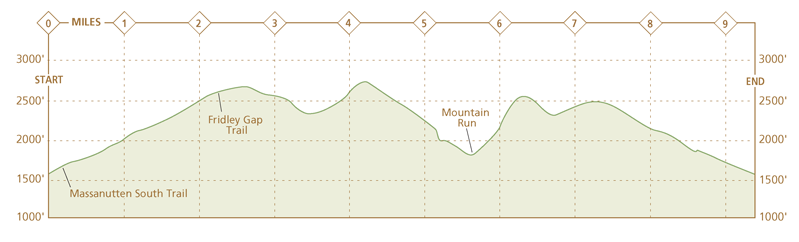
0.0Start at a gate across FR 65 at the end of gravel VA 636. Walk past this gate up the left side of the road. Boone Run flows in the gully on the left.
0.2Descend left off the FR 65 road embankment, following orange blazes of the Massanutten South Trail. The trail immediately crosses a stream. The trail is as wide as an old road, narrows into a footpath, then widens again. Watch for orange blazes. Faint traces of old roads branch into the woods.
0.7Hillsides close in and Massanutten South Trail narrows to become a footpath. Boone Run cuts through some impressive exposed rock that shows the uplifting that created the series of First, Second, and Third Mountains.
1.0Hike past a blue-blazed trail on the left. In a few feet, a white-blazed trail goes left to a shelter in 0.1 mile. Note: The blue-blazed trail leads to Kaylor Knob.
1.9The trail steepens. Boone Run, once a bubbling stream, is a dry, sandy groove in the hillside.
2.2Follow the Massanutten South Trail as it enters a clearing and turns left at a four-corners trail junction. Note: The trail straight ahead is Fridley Gap Trail, which is the return leg of this loop hike.
3.1Massanutten South Trail, as it descends Third Mountain, narrows and enters a dark cove on Fridley Run. There is a campsite here.
3.5The trail wraps around Fourth Mountain and steepens.
4.0Begin a descent off Fourth Mountain.
4.2Pass a campsite on the left. There is a rock outcrop and views behind the campsite. The next 0.5 mile brings more excellent views on similarly marked trails on the left.
5.4Massanutten South Trail crosses Fridley Run just above the stream’s junction with Mountain Run. There is a waterfall and deep swimming hole near here. This spot gets heavy use from day-trippers, with FR 722 just 0.5 mile downstream.
5.5Turn left and hike uphill. In a few feet, turn right onto purple-blazed Fridley Gap Trail. Note: At the junction with Fridley Gap Trail, the Massanutten South Trail goes straight, eventually reaching the national forest visitor center at New Market Gap.
6.3After a very steep climb, cross the wooded crest of Third Mountain.
6.6Exit the woods onto a dirt road. Turn right and follow Fridley Gap Trail uphill. Note: The road on the left is the Martin Bottom Trail.
7.2Enter a clearing at a four-way trail junction and turn left to continue on Frid ley Gap Trail as it climbs Second Mountain. The trail climbs through an area scarred by a wildfire caused by a lightning strike.
7.6Crest Second Mountain and begin a descent along a rough, rocky trail.
8.1Reach Fire Road 65A and turn right (south) to follow the dirt and gravel road downhill.
9.4Arrive back at the gate across FR 65.
HIKE INFORMATION
LOCAL INFORMATION
Harrisonburg is the closest city with amenities of all kinds, being a college town. Harrisonburg Tourism, (540) 432-8935, www.harrisonburgtourism.com
Shenandoah Valley Travel Association, New Market, (877) VISIT-SV www.visitshenandoah.org
LODGING
Stonewall Jackson Inn Bed & Breakfast, (540) 433-8233, www.stonewalljacksoninn.com. B&B in a 1885 restored mansion close to downtown Harrisonburg.
Massanutten, (540) 289-9441, www.massresort.com. A four-season east of Harrisonburg and close to the trailhead. Golf, spa, ski, or play in the indoor water park.
RESTAURANTS
Harrisonburg’s downtown food scene is eclectic and fun. Billy Jack’s Wing & Draft Shack is a favorite for casual pub grub and beers: 92 S. Main St., Harrisonburg; (540) 433-1793; www.billyjacksshack.com.