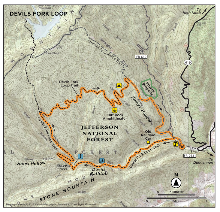
36. DEVILS FORK LOOP
WHY GO?
Devils Fork is a luxuriant streamscape of rocks, cliffs, and small cascades that grow in size and frequency as you hike. It all comes together at the Devils Bathtub, where a long waterfall trips step by step over shale bedrock and crashes in a swirl of currents into a bowllike pool—the bathtub. Framed by tall hemlocks and rhododendron, this scenery is as lush and abundant as the landscape a few hundred feet upslope is simple and unadorned.
THE RUNDOWN
Start: Forest gate at the end of FR 2631
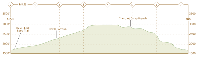
Distance: 7.1-mile loop
Hiking time: About 4 hours
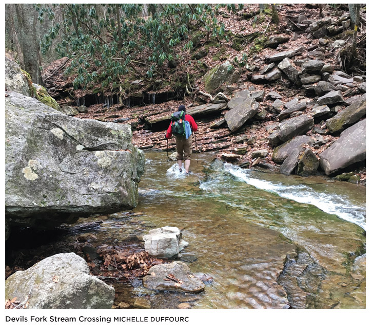
Difficulty: Strenuous due to the many unaided stream crossings, a narrow ledge and one steep climb
Trail surface: Dirt footpaths and dirt roads lead through hardwood forest slopes and hemlock groves along streams.
Land status: National forest
Nearest town: Norton, VA
Other trail users: Hikers only
Accessibility: None
Canine compatibility: Dogs permitted
Trail contact: Clinch Ranger District, Norton, (276) 679-8370, www.fs.usda.gov/gwj
Schedule: Open year-round. Hunting is allowed on national forestland. Deer-hunting season in Scott County runs Oct through Jan. The national forest limits hiking groups to 10 people.
Fees/permits: High Knob Recreation Area day-use and camping fees; Bark Camp Lake Recreation Area day-use and camping fees.
Facilities/features: None
NatGeo TOPO! map: East Stone Gap, Fort Blackmore
NatGeo Trails Illustrated map: Clinch Ranger District
FINDING THE TRAILHEAD
 From VA 72 North near Fort Blackmore, turn left on VA 619 (Big Stoney Creek Road). Go 3.6 miles to the community of “Ka.” In 0.6 mile, turn left on “High Knob SC” (it is still VA 619). In 0.3 mile, see an abandoned house on the left, surrounded by a chain-link fence, and a very rough dirt road to the left of the house. There are No Trespassing signs, so no parking here. You can drive this forest road, but 4WD or high clearance is recommended. Go 0.2 mile to a clearing to park. Look to the right of the clearing for the trail sign, concrete steps up an incline and yellow tree blazes. GPS: N36 49.107’ / W82 37.602’. DeLorme: Virginia Atlas & Gazetteer: Page 20, B3.
THE HIKE
The trip up Devils Run hollow is 3 miles of tricky hiking. At each stream crossing, shrubs and ferns hide where the trail might climb the opposite bank, however the trail is very well-marked, with brown trail markers every half mile as well as yellow tree blazes. The deeper into the hollow, the more damp and shaded the scenery. The rocky, uneven trail creeps up in elevation until stream banks become small cliffs, and the river froths 20 feet below your feet.

This ruggedness makes it hard to fathom how a railroad once ran along this stream. It’s been 70 years or more since private landowners carted oak, beech, chestnut, and poplar trees off the mountain slopes around Devils Fork. These were old-growth trees, described by one 19th-century traveler as “walls and buttresses, square structures like the titanic ruins of castles.” As had been the case throughout much of southwest Virginia, companies from New York and Philadelphia owned the timber. A sawmill could produce 12,000 board feet from just three of these trees. (A small home uses about 6,000 board feet of timber—which means three of these trees could supply the lumber needed for two homes.) At the other end of the scale, Singer Manufacturing Company bought and removed all black walnut of a certain size in neighboring Wise County for their sewing machine cabinets and base plates.
Halfway between Straight Branch and Devils Bathtub, a rusted coal car lies half-buried in trailside brambles. Uphill from this, speculators dug a mining prospect in search of coal. These were “punch mines,” small dents dug out of hills in hopes of finding a vein. Coal’s era has passed, while natural gas production is rising. The return leg of Devils Fork Loop crosses a dirt road high on Stone Mountain. Embedded in the dirt road path are signs of modern prospecting. Exploratory drilling for natural gas produces long pieces of smooth, round stones—as large as a silver dollar and broken into 2- or 3-inch pieces.
When coal miners worked this area, they did so exclusively on the north bank of Devils Fork. The stream follows a geologic fault between sandstone on the north stream bank, which holds coal deposits, and limestone on the south bank. On its north stream bank, acid soil supports the hemlock and rhododendron that lend the hollow its lush setting. There are few, if any, of these type of plants on the south stream bank, where the soil is less hospitable.
HEADS UP
Prepare to get wet, as there are many stream crossings on this hike, at least five in the first mile alone! Best done in warmer weather.
The hemlocks along Devils Fork are second- and third-growth. Rhododendron, which seems to grow hand in hand with hemlock, fills the gaps in the forest floor. A spring hike here, while certain to net you wet feet, also leaves a lasting impression of both these evergreens. As you climb, the hemlock and rhododendron decrease in number until, on well-drained mountain slopes, white oak and hickory trees form the forest canopy. Off the slope run five streams and numerous seasonal runoffs, all of which feed Devils Fork. A century ago, when chestnut trees grew tall and wide, loggers would range throughout this forest, cutting rings around the trunk at certain intervals. Using tools called spuds, they ripped bark from the tree in sheets, piled it high onto wagons, and hauled it to tanneries. Before railroads and on-site sawmills, the trees were too difficult to remove. More often than not, they were left to rot.
At times, the route across Stone Mountain’s slope pitches sharply downhill and right. This pitch is what, in part, led Appalachian Power in the mid-1970s to propose flooding Devils Fork and creating a reservoir out of the stream valley. Using a pipeline, the company could have generated electricity by directing the flow of water between the proposed reservoir and Big Cherry Reservoir on Long Mountain. Opposition from local residents was swift, and Appalachian Power abandoned the plan. The idea of protecting Devils Fork persisted, however. When the national forest proposed a road up the side of Little Mountain, a local trail club rose to the cause. Roadwork progressed to the point where a survey crew cut a first pass through the forest, but then the project was dropped. Sensing an opportunity, the trail club made use of the crew’s work. Today, the road that would have opened the Devils Fork watershed up for timber harvest and natural gas production is one section of this loop.

MILES AND DIRECTIONS
0.0Start at a parking area on FR 2631. Depart the parking area by walking up a flight of tall stairs and turning left on the dirt and gravel forest road.
0.1Cross Straight Fork. In a few feet, bear left at a double yellow blaze, avoiding a trail that branches right. Note: The yellow-blazed dirt road that arcs right and uphill from this clearing is the return leg of this loop.
0.3Cross Devils Fork, the first of numerous crossings in the next 2 miles. The trail alternates between wide, flat stretches and narrow, eroded footpaths. Sections of trail often merge with the streambed itself. After spring floods, parts of the trail may be washed out or blocked by downed trees.
0.6After crossing Devils Fork several times, stay alert for ruins of a small railcar on the right side of the trail. (A narrow-gauge railroad once ran alongside Devils Fork, used to haul out lumber from the stream valley.)
1.4Arrive at a scenic crossing of Devils Fork. Just downstream, the river bends and the stratified layers of bedrock are visible where the stream has eroded and undercut the stream bank.
1.5In an area of fallen rocks strewn around the trail, a tall cliff face rises five stories high on the left side of the trail. Descend along the trail to the stream and the first of the “tubs” that comprise the “Devils Bathtub.” (Devils Bathtub’s name derives from the way the stream pours down a V-shaped cut in the shale streambed and swirls in whirlpool fashion into a round “tub,” or basin at the foot of the falls.)
2.1The trail takes a sharp right turn and heads northwest out of the Devils Fork gorge. Deep Hollow forms below on the right.
2.3After a steep climb on a woods path, the trail merges with an old roadbed, which is a wide, graded, and grassy path. In 0.1 mile after this merge, turn right at a double yellow blaze and descend into Deep Hollow on a footpath. Cross the small stream and climb the opposite hillside.
2.8Switchback over a shoulder ridge separating Deep and Corder Hollows. The footpath will climb, then drop off this ridge into Corder Hollow.
3.6Cross a streambed (dry in late summer) and begin a traverse of Little Mountain’s undulating slope. A number of streams run down this hill to Devils Fork.
4.1Veer left and downhill at a double yellow blaze on the trail.
4.6Crest a small knoll and note the six-trunked tree. (Trees with two or more trunks are common in woodlands that were once logged. It is evidence of girdling, or removing a ring of bark between knee and waist high. This kills the tree above the girdle mark but not below. The still-living trunk will often sprout two or more trunks as it grows again.)
4.8Turn right at a double blaze and descend right off the hillside into a gully. There is a natural rock amphitheater here along the right side of the trail.
4.9Bear right as the trail merges with a faint road trace.
5.5Straight Fork Ridge Trail enters from the left. Turn right and begin a descent to Straight Branch. Tree blazes become much less frequent, but it’s easy to follow the wide old logging road.
6.0Bear right as the trail merges with another grassy road. Uphill is private property.
7.0Enter a clearing alongside Straight Fork. Cross the stream and hike up a small knoll on the dirt/gravel forest road.
7.1Arrive back at the parking area on FR 2631.
HIKE INFORMATION
LOCAL INFORMATION
Scott County Tourism, www.explorescottcountyva.org
Wise County Tourism, (276) 328-2321, www.visitwisecounty.com
Heart of Appalachia, St. Paul, (276) 762-0011, www.heartofappalachia.com
LOCAL EVENTS/ATTRACTIONS
Carter Family Memorial Music Center, weekly live music shows, 3449 A. P. Carter Hwy., Hiltons; (276) 594-0676; www.carterfamilyfold.org
Country Cabin II, 6034 Kent Junction Rd., Norton; (276) 679-3541; www.appalachiantraditionsinc.com. Live old time and bluegrass every Sat night.
LODGING
High Knob Recreation Area, Norton, (276) 679-1754. Camping May 15–Sept. 15.
Bark Camp Lake, Coeburn, (276) 328-2931. Camping May 15–Sept. 15.
Natural Tunnel State Park, Duffield, (276) 940-2674, www.dcr.virginia.gov/state-parks/natural-tunnel.
Camping and cabin reservations: www.reserveamerica.com
Jessie Lea RV Park, Big Stone Gap, (276) 523-0055, www.jessielearv.com