39. LITTLE WILSON CREEK WILDERNESS
WHY GO?
Most hikers enter Little Wilson Creek Wilderness on trails out of Grayson Highlands State Park. Scales, an area named for the livestock scales once located here, makes a great alternate starting point. You not only avoid crowds but get a high-country fix that much faster. Scales sits smack-dab in the midst of Mount Rogers’s crest zone, flanked by Stone Mountain and Wilburn Ridge. Huckleberry bushes bloom profusely (there are reports of folks carrying 3 gallons or more out of thickets along Scales Trail). On Stone Mountain, wild horses graze. As you approach them, young foals bolt from cover of tall grass and dart behind their mothers. In the words of a passerby, “It’s as wild as it gets up here.”
THE RUNDOWN
Start: Corralled campground at Scales
Distance: 7.6-mlle loop
Hiking time: About 5 hours
Difficulty: Moderate due to some long climbs and several muddy, eroded sections of trail
Trail surface: A combination of dirt footpaths, old dirt wagon roads, and railroad grades lead through high-altitude meadows, mountain balds, and mixed hardwood forests.
Land status: National recreation area
Nearest town: Troutdale, VA
Other trail users: Equestrians
Accessibility: None
Canine compatibility: Dogs permitted
Trail contact: Mount Rogers National Recreation Area, Marion, (276) 783-5196 or (800) 628-7202, www.fs.usda.gov/gwj. The visitor center is 10 miles north of Troutdale on VA 16. Grayson Highlands State Park, (276) 579-7092, www.dcr.virginia.gov/state-parks/grayson-highlands.
Schedule: Open year-round. Hunting permitted, with the busiest season between Nov and Jan. Forest rangers conduct prescribed burns outside the wilderness in fall and spring.
Fees/permits: No permits required. Free backcountry camping. Day-use fee if entering from Grayson Highlands State Park.
Facilities/features: None
NatGeo TOPO! map: Trout Dale
NatGeo Trails Illustrated map: Mount Rogers High Country; Mount Rogers National Recreation Area; Appalachian Trail, Damascus to Bailey Gap; New River Blueway
Other maps: Mount Rogers High Country & Wilderness map available at the Mount Rogers Visitor Center; Appalachian Trail Map 1: Mount Rogers National Recreation Area available from Appalachian Trail Conference, Harpers Ferry, WV. Maps and guidebooks available at Mt. Rogers Outfitters, Damascus.
FINDING THE TRAILHEAD
 Four-wheel-drive vehicles with high clearance: From Troutdale, take VA 603 west from its intersection with VA 16. In 2.8 miles, turn left onto FR 613, a dirt road. (Look for a sign on the right-hand side of the road.) Road conditions are rocky, rutted, and sometimes wet. Once on FR 613, you’ll pass a fork at 0.7 mile. Turn left. Turn left at the second fork at 2 miles. At 2.8 miles, turn right at the fork. In 3.8 miles, pass through a metal gate (the gate may be closed, but not locked). In 0.2 mile past the gate, enter the campground at Scales. GPS: N36 40.165′ / W81 29.224′. DeLorme: Virginia Atlas & Gazetteer: Page 23, C5.
Two-wheel-drive or low-clearance vehicles: From Troutdale: Drive south on VA 16. In 7 miles, turn right onto US 58. It is another 7.6 miles on US 58 to the Grayson Highlands State Park entrance road, VA 362. Turn right onto VA 362 and, in 3.1 miles, turn right onto the Grayson Highlands State Park campground access road. It dead-ends at the campground in 1.3 miles. The Wilson Creek trailhead is clearly marked near the ranger station. Follow it downhill and, in 1.8 miles, turn right onto Scales Trail, which is an old road. Reach the Scales area in 1.3 miles (for a total trip of 3.1 miles from the state park campground). GPS: N36 38.404′ / W81 29.227′. DeLorme: Virginia Atlas & Gazetteer: Page 23, C5.
THE HIKE
They stare at you from a black-and-white photograph, fourteen men in dirty overalls wearing brimmed hats, saws and poles gripped firmly in hand. Remember them as you soak in the high-country meadows around Scales, a swale in Pine Mountain tucked between Wilburn Ridge and Stone Mountain. If not for loggers like them, this landscape wouldn’t exist.
Transformation of Scales, once a weigh-in site for livestock, took a mere 20 years. Starting around 1900, lumber companies and private landowners stripped virgin spruce and fir, chestnut, maple, and oak from the hillsides. What’s developed since is a product of man and nature. Erosion carried away fertile soil and exposed portions of volcanic bedrock. Livestock grazing and periodic fires set by the Forest Service keep the forest at bay. From this, Virginia’s most striking landscape evolved: miles of meadow awash in green, orange, red, and purple cresting against a horizon filled with Virginia’s highest peaks, fading into the haze of North Carolina’s Blue Ridge.
First Peak Trail climbs through just this type of landscape en route to Little Wilson Creek Wilderness, a 3,900-acre tract protecting three peaks and five creek watersheds, including the dual headwaters of Little Wilson Creek. As you pass just under the summit of Third Peak, isolated clumps of hawthorn, buckeye, and beech grow increasingly thick and dense. This is how all of the Mount Rogers’s crest zone—land 4,000 feet or more above sea level—would look if left to nature. Huckleberry grows in ever-larger thickets. Scrubby witch hazel (the divining rod of choice for modern-day dowsers), flame azaleas, and mountain laurel grow head-high. Small American chestnut intersperse with beech and chinquapin oak.
A blight has stunted the chestnut from growing even big enough to produce its burrlike fruit. Only 100 years ago, it grew so large, residents of Troutdale, a boomtown at the foot of Pine Mountain, cut 12-by-12-by-2-inch-thick pieces for stepping-stones across their muddy roads. C. P. Greer, a Troutdale resident, logged trees so big in this wilderness that, with his daughter perched on his shoulders, the base of a felled tree dwarfed them both. Greer is the man responsible for the faint trace of railroad grades visible on High-tree Rock Trail, one of the wilderness’s less-traveled footpaths. He built a small-grade railroad on his own land to carry logs to his mill on Fox Creek, where he processed it for furniture and building material. (Ever the entrepreneur, Greer later converted the mill into a dynamo, or power plant, and supplied Troutdale’s first electricity.) It was in the vicinity of Hightree Rock that Greer felled his largest trees. A mile and a half past where it splits from First Peak Trail, the Kabel Trail takes on the appearance of an old railroad grade: wide and flat with high banks. What might have been a rail spur angles left and peters out in thick woods. Rocks buttress the underside of the trail here, the masonry work visible by looking downslope off the left side.
Hawthorn, identifiable by its thorny branches, is a common tree sprouting from the thin soil of Mount Rogers high country. There are at least 165 species of hawthorn. Of them, thirty are native to the eastern region of the United States. Around Mount Rogers, you can narrow the search to cockspur, fanleaf, dotted, red plum, and fleshy hawthorns, all of which grow at elevations of 5,000 feet or higher.

Locomotives crossed grades like this daily during the boom years on Pine Mountain, traveling from Fairwood, a company town on FR 613. Before a fire destroyed it in 1911, Fairwood served as base of operations for the U.S. Spruce Lumber Company’s Pine Mountain operations. Life there and in nearby Troutdale hummed along with the lumber business. Two furniture manufacturers employed any able-bodied man not working in timber. Farmers traveled the dirt roads between their homes and town, carrying livestock and produce to a rail depot at Troutdale. On their return trip, they were loaded with chairs from the factory for their wives and children to cane. Passenger trains ran twice a day from Troutdale south to Sugar Grove and Marion. For a time, Troutdale families rode the rails to Fairwood every Fourth of July for an annual baseball game, since the Spruce Lumber Company had built the finest baseball diamond in the valley.
It was for Spruce Lumber Company that engineer Kent Steffey worked on the fateful September day he took a Shay Locomotive No. 9 up Pine Mountain. After uncoupling a boxcar and reversing the engine, he started downhill. The train gathered speed and Steffey blew two sharp whistles, signaling for brakes. Nothing happened. The train careened on. Steffey’s repeated whistle blows pealed across the mountain. The conductor and fireman jumped, but Steffey stayed aboard. Workers later found his body under the smoking wreckage of the 65-ton Shay. All that’s left today is his tombstone in Rural Retreat, Virginia, and a ballad, “The Wreck of Ole Number Nine.”
Still on the rails the bell / Began its pondering clang / And out upon the mountain air / the mourning whistle rang / “Farewell, farewell,” it seemed to say / And the wheels like death did sing / It struck the curve with an awful shock / And from the rails she sprang.
They stare at you, men in dirty overalls and brimmed hats sitting atop Steffey’s wrecked Shay No. 9. Say what you will about habitats destroyed, species lost, trees gone forever. But don’t forget their faces.
MILES AND DIRECTIONS
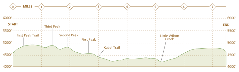
0.0Start from the trail board at Scales, an enclosed campground on Pine Mountain. Past the trail board, exit the corral via a pass-thru in the fence. Turn left, keep the fence to your left, and round the next corner of the corral. Bear right and uphill at a signboard for First Peak Trail. Note: Avoid the Appalachian Trail (AT), which also ascends through these fields. The AT is clearly marked with white blazes.
0.8Pass a junction with Third Peak Trail; continue straight.
1.0Pass a campsite on the left side of the trail. This is an ideal spot for anyone looking for a sheltered evening under red spruce and hardwoods.
1.1Pass to the right of 4,920-foot Third Peak.
1.8Near the top of Second Peak, look out for several footpaths, unblazed, that branch left and disappear into the low forest cover. These trails lead a few hundred feet to a rock outcrop with views. Continue straight on First Peak Trail.
2.3Enter a clearing. A fire ring marks this as an established backwoods campsite and there are signs of heavy use. Pass straight through the clearing on the First Peak Trail. Note: Bearpen Trail departs this clearing to the right. It descends to Little Wilson Creek before climbing to a junction with Big Wilson Creek Trail.
3.0Reach a T junction and turn right onto Kabel Trail. Note: Hightree Rock Trail leads left from this T junction to an overlook in 2 miles.
4.8After passing over some wet ground, climb on Kabel Trail as the route widens from a footpath into a dirt road.
4.9Turn sharply left and downhill, still on the Kabel Trail.
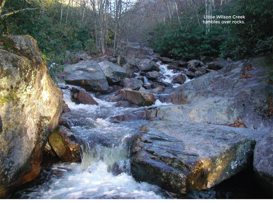
5.2Cross a fork of Little Wilson Creek. There’s a prime camping spot on the left in a grassy meadow before you cross.
5.5Kabel Trail ends at Big Wilson Creek Trail. Turn right onto Big Wilson Creek Trail.
6.2Leave the Little Wilson Creek Wilderness. Just beyond the wilderness sign, Big Wilson Creek Trail intersects Bearpen Trail at a T junction. Turn left onto Bearpen Trail. Note: A right turn onto Bearpen leads back to First Peak Trail. Hiking on this portion of Bearpen Trail is not advisable in wet weather because of eroded and muddy trail conditions.
6.4At a four-way intersection, turn right onto the AT and climb. The trail crosses a barbed-wire fence on a step-up and enters high-country meadows. The grass is waist-high in spots, tall enough to hide young foals resting on the ground. This stretch of the AT is one of the best to see the wild horses of Mount Rogers high country, in part because it is less traveled than trails near the Mount Rogers summit.
7.6Hike ends at Scales. Note: If your hike began in Grayson Highlands State Park, it’s another 3.1 miles on the Scales Trail and Wilson Creek Trail to the campground and parking area.
HIKE INFORMATION
LOCAL INFORMATION
Town of Damascus Tourism, (276) 475-3831, www.visitdamascus.org
Grayson County Tourism, Independence, (276) 773-2000, www.graysoncountyva.com
Abingdon Convention & Visitors Bureau, Abingdon, (800) 435-3440, www.visitabingdonvirginia.com
LOCAL EVENTS/ATTRACTIONS
Appalachian Trail Days, third week in May, Damascus, (276) 475-3831, www.traildays.us. Annual gathering of AT thru-hikers in the town dubbed “friendliest town on the AT.”
Virginia Creeper Trail is a 34-mile rail-to-trail from Abingdon to Damascus. Outfitters will transport you and their rental bikes (or yours) to the top of Whitetop for a 17-mile downhill ride to Damascus. www.vacreepertrail.org
The Mt. Rogers Volunteer Fire Department holds three great festivals each year: Maple Festival in Mar, Ramp Festival in May (ramp is a wild onion), Molasses Festival in Oct. www.mtrogersvfd-rs.com.
LODGING
Grayson Highlands State Park, Mouth of Wilson, has hiking trails, a museum/visitor center, store, cabins and campground for both tents and RVs. (276) 579-7092, www.dcr.virginia.gov/state-parks/grayson-highlands. Reservations: www.reserveamerica.com
Damascus Old Mill, Damascus, has dining and lodging overlooking a beautiful stream. (276) 475-3745, www.damascusinn.com
More than a half-dozen Damascus residents have turned their homes into bed-and-breakfasts to accommodate the many hikers and bikers who frequent the small town. www.visitdamascus.org
RESTAURANTS
Damascus Old Mill, (276) 475-3745, www.damascusinn.com. A recently renovated 1912 mill turned restaurant and sports bar with outdoor seating on the banks of Laurel Creek.
Cowboys deli, Damascus, (276) 475-5444. Great southern breakfast located inside a service station.
Damascus Brewery & Restaurant, (276) 469-1069
ORGANIZATIONS
Friends of Mount Rogers, www.friendsofmountrogers.org
OUTFITTERS
Mount Rogers Outfitters, Damascus. (276) 475-5416, www.mtrogersoutfitters.com. Located “on the AT” on Laurel Avenue., Damascus’s main street. Great gear, hostel and shuttle services.
OTHER RESOURCES
Appalachian Trail Guide to Southwest Virginia, Appalachian Trail Conference, Harpers Ferry, WV, (304) 535-6331, www.appalachiantrail.org
