3
Water
To say that water is important for human survival is an understatement. It is more than the fluid that passes through us; it’s in every part of us. Water is not just in our blood; it’s in our tissues, our bones, our organs. We’re not just more water, by weight, than anything else; we’re more water than everything else combined. We need to drink water because it is a critical component of the processes that allow us to live, as it is critical for all living things on Earth.
In addition to being important for life on Earth, water is also important for shaping the earth. The movement of water is driven by gravity. It falls from the sky as precipitation, moves in rivers from higher to lower elevation, and depending on the amount of water and the shape of the channel, moving water can spill over riverbanks. Water moves fine sand and large boulders alike, and washes away trees and anything else that happens to be on the riverbank. Cars and parts of houses are occasionally seen floating downstream, a result of poor planning and not appreciating the power of water in shaping Earth’s surface. Yet as destructive as these forces can be, high-flow events, and the renewing processes that occur during the lower-flow conditions that follow, are essential for sustaining aquatic ecosystems that have characterized rivers for millions of years.
SCALING WATER: FROM MOLECULES TO OUR ENVIRONMENT
Two atoms hydrogen, one atom oxygen — on its face, water seems so simple. Yet its molecular shape, and the capacity of hydrogen and oxygen to act independently and together, allows water molecules to interact in ways that other molecules cannot. Water is unique at a molecular scale because it can take a solid particle, break it apart, and hold it in a liquid form. The polarity of water (its nonlinear, asymmetrical shape and charge) allows it to dissolve salts and other compounds like ammonia and urea, as well as larger molecules that need to be exported from the body.

The water molecule. The polarity of the molecule is shown as dark hydrogen atoms (positive) bonded to a light oxygen atom (negative). Used with permission from the National Energy Education Development Project, www.need.org
The chemical properties of water have other important implications for life on Earth. One of the most important of these is that hydrogen bonds are regularly formed between adjacent water molecules: Hydrogen bonds are relatively weak forces, compared with bonds that hold atoms together within a molecule, but it’s these weak bonds that allow water molecules to form liquid water, water vapor, and solid ice, a unique natural phenomenon. In liquid water, hydrogen bonds form and fall apart quickly and locally (at the molecular level) but provide sufficient structure to give water its surface tension. Surface tension due to hydrogen bonds provides the resistance that allows water striders to skate on the water’s surface. In its solid form (ice), hydrogen bonds are more stable and create an organized lattice of molecules that are less tightly packed, compared with water in the liquid form.
One of the most important and rarest properties of water is that ice floats because water is denser than ice. The tendency for solid ice to float is why we can skate, walk, and drive over frozen water bodies even if they are not frozen solid. More important for Earth’s ecology, however, is the fact that plants and animals can survive beneath ice that covers lakes, despite freezing outside air temperatures. If ice sank to the bottom of a lake, it would eventually fill the lake and trap organisms living in the lake. Instead, ice formed on the top of lakes, rivers, and oceans remains floating on the top, while the water below and many of the organisms within it generally remain above freezing for the entire winter. Ice fishermen have hydrogen bonds to thank for their recreational activity and may also have hydrogen bonds to blame when pipes burst as a result of freezing. On a larger scale, this is also the reason we have icebergs and Arctic sea ice, which climate scientists have found are important for regulating air and water temperatures across the planet.
THE WATER CYCLE
There is an amazing synchrony between Earth’s climate and the properties of water: the planet’s temperatures tend to fluctuate between freezing and boiling, so we have water as a liquid in oceans and as it flows and rests on land in rivers and lakes; as solid ice in colder environments; and as gas in the atmosphere. But where is most of our water, and how does it reach us? These questions can be answered as we consider the water cycle.
The location and movement of liquid water is controlled by gravity. Rain falls downward, rivers flow from higher elevation to lower, and lakes and vernal pools seep slowly into the soil, all because liquid water weighs more than air. Despite the fact that most of the water we commonly see is flowing over or sitting on land, freshwater represents a small fraction of all the water on Earth. In fact, it’s a very small fraction — only 1 percent of all water on Earth is present as freshwater, including all lakes and rivers, all groundwater, and all the water present in living things. Approximately 2 percent of Earth’s water is frozen as glaciers, even with recent climatic warming. In contrast, 97 percent of the water on Earth is found in the ocean as salt water.
If you’ve ever sat on the banks of a river, it may have crossed your mind that water is constantly moving from the mountains to the sea. The Sacramento River, the Los Angeles River, and all other rivers are on the move. But where does the water in rivers come from? And why don’t rivers eventually run dry? Hydrologists call water’s journey, from land to oceans and back to land, the water cycle. The key to the cyclical movement of water between land and sea is the repeated transformations between its solid, liquid, and gas forms.
Evaporation of ocean water can be considered the first step of the water cycle. Though we commonly think of the movement of water from liquid to gas as happening through boiling, the ocean doesn’t boil (unless it’s near volcanic vents like those in Hawaii and Iceland). Evaporation in the ocean occurs as a result of wind and solar radiation at a microscopic scale, and it occurs over an incredibly large area — recall that over two-thirds of Earth’s surface is ocean. Once water is converted to a gas, it may rise, cool, condense into tiny droplets, and join with other tiny droplets, forming clouds. If the droplets continue to combine and get large and heavy enough, they will fall as rain or snow, depending on the air temperature. Most precipitation occurs over the ocean, but if wind blows clouds over land, there’s a good chance that some of that water will fall on land as well.

The water cycle is driven by energy from the sun. Copyright, University Corporation for Atmospheric Research
Whether precipitation falls as rain or snow has important implications for the water cycle. In general, most rain that falls on land is absorbed into the ground. Lakes and rivers themselves cover only a small fraction of the land surface, and physical processes such as sheetflow — water physically moving across the surface as a sheet, rather than concentrated in a channel — are rare under natural conditions. Sheetflow is common in urban environments where roads and other impervious surfaces don’t let water seep through, producing rapid runoff. Most water that reaches streams does so by traveling underground. When it rains, water soaks into the ground, through the soil and into groundwater-holding areas. However, groundwater bodies may be less permeable than the soil above, so water may accumulate in the soil as it slowly percolates downward. As the amount of water in the soil increases, the level of saturated soils (or the water table) rises. Eventually, the water table can reach the surface, filling low-lying pools and stream channels.

California precipitation. Annual average rainfall generally increases from south to north and decreases on the east side of mountain ranges (rain shadows). Modified from the National Atlas, 2005, US Geological Survey, www.nationalatlas.gov.
Approximately 60 percent of precipitation ends up in streams in a typical year. Some of the remaining water that does not convert to stream flow reaches deeper groundwater, and some is taken up by plants. The water taken up by plants in California is less, in general, than in other parts of the United States because most precipitation here occurs during the less biologically active season of lower temperatures and fewer hours of sunlight. A very small amount of water is consumed by animals, and some evaporates directly from rivers and lakes.
Most rainfall is converted to runoff relatively quickly, usually in less than a day, so elevated stream flow tends to occur on the same day as a rainfall event. As a result, the highest levels of stream flow occur during the rainy season (November to April), when precipitation is greatest in California.
Some fraction of the water that is not converted to runoff percolates through the subsurface and becomes groundwater. Think of dripping water onto a dry sponge. At first the water is all absorbed. When the sponge’s water-holding capacity is full, water begins to drip out of the sponge. In this analogy, the sponge is soil and subsurface. Some water gets stored in bedrock, which includes the range of igneous, sedimentary, and metamorphic rocks below Earth’s surface. These different types of bedrock have a wide range of permeability, which is the capacity of material to allow water to pass through. Bedrock with very low permeability acts as an aquaclude (a barrier to groundwater movement), and bedrock with relatively high permeability, such as sandstone and limestone, acts as an aquifer. Aquifers are of particular value because of their capacity to store and provide a water supply at a fast enough rate to be beneficial for human use. Some types of volcanic rock are highly porous and may hold huge amounts of water in underground aquifers.
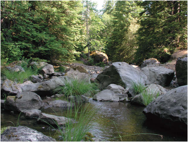
North fork of the Garcia River, Mendocino County, June photo. Water level is low and will drop through October. In winter, when stream flow is highest, all the rocks in the photo would be submerged. Photo by Kerry Heise ture of land-locked areas called internal (or endorheic) basins. This occurs almost exclusively in areas that can be technically defined as desert (areas having less than 10 inches of rain annually). These basins include the Mojave River which feeds the seasonal Soda Lake in San Bernardino County; the Owens River which historically fed Owens Lake in Inyo County; and Walker, Lee Vining, and Rush Creeks which feed Mono Lake.
Snowfall is retained throughout the winter and generally is not converted to stream flow until spring and summer. Snowmelt tends to arrive in streams in late spring and summer when air temperatures are sufficient to melt snow. However, there can be an exception to this pattern when air temperatures are warm enough for precipitation to fall as rain at high elevations where snow is already on the ground. This phenomenon is termed a “rain-on-snow event.” Snow covering the land acts as a barrier to absorption. In addition, the rain melts the snow, causing a doubling of effective precipitation; the rapid conversion of rainfall and snowmelt into stream flow tends to cause flooding both locally and in valleys downstream.
Most streams in California eventually run into the ocean, but not all: in some parts of the state, streams drain to low-lying basins, a fea-

Soda Lake, seen from the southwest flank of Little Cowhole Mountain, Mojave National Preserve, San Bernardino County. Photo by Stan Shebs
Lakes in low-lying desert basins such as these are referred to as alkaline because of their high salt content. They have high salt concentrations because rainfall leaches salt from rocks and soil. When streams with any amount of salt, however tiny, run into an undrained basin, the salt accumulates. The alkaline Great Salt Lake in Utah is a result of this natural process. Several southern Central Valley rivers, including the Kern, Kaweah, and Kings, were historically disconnected from the ocean for all but the wettest years, when the entire valley could flood and connect these streams to ocean-going rivers to the north. Before the lower Central Valley was channelized and divided up into cropland, these rivers comprised much of the source of historical Tulare Lake, a low-lying chain of lakes south of the San Joaquin River that historically was only connected to the San Joaquin during the wettest of years. For this reason the south Central Valley is considered an alkaline basin.
Though the topography and geology of California generally does not lend itself to the formation of large natural lakes, there are a few, including Lake Tahoe, Clear Lake in Lake County, and Upper Klamath Lake (just to the north, in Oregon). Water reaching Upper Klamath Lake drains from over 3,800 square miles (an area larger than the entire Eel River watershed). From there the Klamath River continues to flow through Northern California, having drained a total area of over 12,000 square miles by the time it reaches the ocean.
Clear Lake is the largest natural lake located entirely in California, and thought to be the oldest lake in North America. Its outlet is the source of Cache Creek, which drains to the Sacramento Valley. Approximately 10,000 years ago, Clear Lake drained to the Russian River, before a landslide changed its course. Lake Tahoe is the source of the Truckee River, which flows east into a closed basin in western Nevada. Most naturally occurring lakes in California are much smaller than these three. Hundreds of tiny alpine lakes are nestled in mountain cirques across the high Sierra Nevada, Cascade, and Southern California mountains. Cirques (pronounced “serks”) are bowl-shaped depressions carved by glaciers. The coastal mountains of California notably have very few natural lakes.
STREAM PROCESSES
Water that reaches a stream channel takes a gravity-driven journey that plays a significant role in shaping the physical and biological landscape. Rivers and creeks, collectively referred to as streams, vary considerably from the smallest rivulets in the mountains to the large, broad waterways that form complex estuaries when they reach the ocean. Whether as small tributary streams in mountain headwaters (the beginnings of streams) or reaches (any other stream segments) farther downstream in a broad river valley, streams have a number of important functions.
The particular characteristics of a stream are heavily influenced by features of its watershed. A watershed includes all of the land from which rain drains through a common stream point. Watersheds are sometimes referred to as catchments or drainage basins, both referring to the idea of water being “caught” as rain or snow and draining to a particular common point. Think of a bathtub with a single outlet; that is a watershed. When your shower water misses the tub and lands on the floor, it has moved into a different watershed! Small streams have small watersheds, but as two small streams join to make a larger one, the stream’s watershed becomes larger as well.

Watershed vocabulary: rain falls in the headwaters, runs from tributary streams into the mainstem river, which meets the estuary just before running through the bay into the ocean. Watercolor by Jenny McIlvaine for the Napa County Resource Conservation District
Streams are classified based on their location and relative size in a river system. This classification system, termed stream order, designates small headwater streams as order 1 (first order) and the largest rivers as order 10 (tenth order). When two first-order streams meet, they form a second-order stream; when two second-order streams meet, they form a third-order stream, and so on. Stream order only increases when two streams of the same order meet; thus, a third-order stream meeting a second-order stream remains a third-order stream. As a result, a large stream increases in order only when an equally large stream joins it. Though it might be expected that large rivers in California would have large stream orders, the Russian River in northern coastal California is only sixth order, and the Sacramento River is only seventh order. The stream order system as applied today in California is based on streams identified by the US Geological Survey in the late nineteenth and early twentieth centuries. Nationally rivers range from first order, with no branches, to tenth order, as represented by the Mississippi.

Stream order numeration: 1 = first order, 2 = second order, 3 = third order, and 4 = fourth order. When two first-order streams join, a second-order stream is formed; when two second-order streams meet, a third-order stream is formed, and so on.
BIOLOGICAL INPUTS
A watershed provides more to its stream than just the water that falls within its boundaries. In addition to water, the watershed provides anything else that can be transported downstream by water. These inputs may be biological, chemical, or physical, and all are relevant to stream ecology.
The insects, fish, mammals, clams, and other animals that live in a stream reach (particular section of a stream) depend on biological inputs such as leaf litter as a food supply. These inputs can come downstream from uplands or from the immediate riparian zone—the transition area between the stream and the terrestrial habitats nearby. The riparian zone is frequently characterized by specialized plants and animals that rely on water from the stream to some extent, but there is a good deal of overlap between these species and those found in the uplands. Biological inputs also come from the ocean to a river! When salmon, lamprey, and other anadromous fish (fish that spend most of their lives in ocean habitats but migrate to freshwater for breeding) swim upstream, they bring energy and nutrients from the ocean to the river.
In addition to providing food, biological inputs from the riparian zone support other stream functions. Trees and branches that have died or have been loosened from the soil sufficiently to fall down a hillslope may end up in the stream; this material, called large woody debris, provides several important instream functions. For some organisms (e.g., for insects that pupate), it provides a substrate for growth or for undergoing life cycle changes. Equally important, it provides a source of nutrients as it breaks down and releases nitrogen, phosphorus, and other elements that aquatic organisms need to survive. Large woody debris also plays an important role in shaping the stream channel. As water moves around it, irregularities in the channel bed form. As water flows over the debris materials, the water scours deeper pools below them. The resulting pools and other variations in the channel shape provide places for smaller fish to hide from predators—protection that is necessary during high flows for fish and other animals at various stages of their life cycles. Maintaining and restoring large woody debris is essential for stream restoration because of the critical role it plays in shaping the channel and providing cover, shelter, and feeding opportunities for stream organisms.
CHEMICAL INPUTS
The chemical properties of water make it well suited for transporting ionic compounds (all together referred to as salts) as the stream moves from headwaters to lower reaches. Water can weather rocks both on and below the surface; in doing so, it can dissolve ionic compounds from rock surfaces it comes into contact with and carry the compounds downstream. This is the primary mechanism that makes desert lakes salty: streams that feed those lakes continuously carry ionic compounds to the lake. As the water evaporates each year, the weathered salts remain in the lake beds.
Other chemical inputs from the watershed have effects on stream ecology. Nutrients that are important for plant growth, such as phosphorus, nitrogen, and carbon, can be weathered from soil and bedrock. These nutrient inputs are autochthonous, meaning that they come from within the watershed. They are important for the growth of algae and other periphyton (simple organisms, sometimes referred to as biofilm, that attach to the bed of a stream), which provide the foundation for many aquatic food webs. These small organisms at the base of aquatic ecosystem food webs are an important food source for larger organisms such as small aquatic insects and other macroinvertebrates (animals that are large enough to see but that don’t have vertebrae, or backbones). These primary consumers (plant eaters) serve in turn as food for larger organisms, including other insects, fish, and birds that turn to aquatic ecosystems for a food source.
A watershed may sometimes provide an unhealthy amount of nutrients to a stream or lake. Water bodies containing large amounts of nutrients are described by the word eutrophic (meaning “well fed,” as opposed to oligotrophic, meaning “poorly fed”) and are frequently characterized by large amounts of algae, other periphyton, or plants. Humans may contribute to nutrient loading in streams and lakes by applying fertilizer to crops or lawns, which may then be carried to streams and lakes. Eutrophic water bodies pose threats to aquatic ecosystems because periphyton and plants that accumulate in lakes eventually die and are decomposed. The bacteria responsible for their decomposition consume oxygen dissolved in the water, which can cause water bodies to become anoxic (without oxygen), meaning that oxygen levels fall below thresholds of tolerance for aquatic animals. In extreme cases, nutrient runoff can lead to dead zones. The Gulf of Mexico Dead Zone covers over 6,000 square miles and is formed each spring because of nutrients (especially phosphorous and nitrogen from fertilizers, sewage, and animal wastes) that run off from farms in the Mississippi River watershed. For more on dead zones see Chapter 7.
PHYSICAL INPUTS
Physical material inputs to a stream play an important role in creating and changing the shape of a stream channel, and in organizing the size and distribution of stream surfaces that support many ecological processes. Geologists and geomorphologists refer to all loose minerals and rock in the river as sediment (the contrast to sediment is bedrock). Sediment refers to a range of size classes, from large boulders to fine silt. Sediments are delivered to streams through two mechanisms: alluvial forces and colluvial forces. Alluvial sediment (or alluvium) is material that has been moved by water, for example, during high-flow events, when channel bed materials are carried downstream by the force of flowing water. High flows may also erode the banks of the channel, taking material previously not in the stream and moving it downstream as alluvium.
Colluvium is sediment that reaches the streams by gravity but not by water. Most commonly, colluvium enters the stream channel through hillslope failures (also termed shallow landslides), when fine and coarse materials (soil and rocks), along with vegetation attached to them, fall into the stream. Rocky materials, such as large boulders that have been fractured and loosened from the bedrock, can enter the stream by colluvial forces but may be too large to be moved by the stream. These boulders are great for climbing or sitting on during the dry season. Frequently, landslides produce a large amount of material that emerges from the rest and forms a “toe” where the landslide meets the river, just like our toes emerge from the base of our feet. Landslide toes may push the creek to the opposite side of the channel or fill the channel completely, causing the stream to begin a search for the weakest or lowest portion of the filled channel to begin carving a new path.
The power of water is ominous and often underestimated. Most material moved by rivers, actually about 90 percent, is suspended in the water. This suspended load can be composed of various materials, including fine sediment that gives high-flowing rivers a muddy appearance. The other 10 percent is bedload, the material that bounces along the streambed. Bedload includes coarse cobble (technically material ranging up to 360 millimeters in size), finer gravels, and sand, as well as boulders that roll along the channel bed under very-high-flow conditions. Next time you’re near a boulder-strewn river or stream, listen for cobble movement. Especially during high-flow events, you may hear cobbles and boulders bouncing along the streambed as bedload!

River vocabulary: rivers move in characteristic ways, creating predictable landform patterns, including oxbows and chutes, oxbow lakes, levees, meander scrolls, and backswamps. From Stream Corridor Restoration: Principles, Processes, and Practices, Federal Interagency Stream Restoration Working Group (FISRWG), October 1998
Though colluvial processes are considered distinct from alluvial ones, hillslope failures generally result from events in which colluvial and alluvial processes coincide. High-flow events that erode the stream channel may undercut hillslopes, causing them to destabilize. Here again we see the incredible force of water from its ability to undermine the stability of whole hillsides. Additionally, hillslope failures often occur when soil is saturated with water, such as during or following a heavy rainfall; hillslopes become much heavier when saturated with water and may become unstable. An underlying principal of hillslope and stream channel erosion is that erosion is a natural process: without erosion, there would be no sediment. Problems can arise, however, when the rates of erosion increase due to land-use activities and more sediment is produced than can be moved downstream by natural alluvial processes. Too much fine sediment in stream reaches can present problems for aquatic organisms that are dependent on clear water and substrate for habitat. For example, in the Elkhorn Slough watershed, upland agriculture led to increased sediment transport between farms and the marsh, burying native pickleweed (Salicornia virginica). Restoration including native vegetation planting, water diversions, construction of water and sediment control basins, and stream channel stabilization resulted in pickleweed marsh recovery.
THE PATH OF A RIVER
The path of a river, from its headwaters as a first-order stream to its outlet, most commonly the ocean, is a complex one. Though most rivers in California run through broad valleys (such as the Sacramento, San Joaquin, Salinas, Los Angeles, and Santa Maria), the majority of a river’s drainage network, by length, is found in the headwaters. For example, more than 75 percent of the Russian River drainage network, in northern coastal California, is composed of first- and second-order streams. For perspective, these streams may range from 8 to 15 feet wide. These river headwaters are commonly in mountain canyons or narrow valleys, where rivers have little room to meander and cut a channel through alluvium. The term for streams whose pathways are limited by canyon walls is confined. Confined streams are not always small; for example, the lower Klamath River, which drains more than 10,000 square miles, runs mostly as a confined stream as it passes through the Klamath Mountains in northwestern California.
The Klamath River is an exception, however. Most rivers across the globe are oriented with headwaters in mountains and then valleys in their downstream portions. Geologists and geomorphologists, frequently thinking about earth-shaping processes over the long term, often refer to valleys along the lower portions of rivers as alluvial valleys, where most of the material filling the valleys has been generated in the mountains farther upstream. Many of the valleys of California formed as long ago as the Pleistocene epoch (2.6 million to 11,700 years ago).
Rivers that run through alluvial valleys are unconfined by mountain walls. They can cut meandering paths through their valleys by eroding banks in places where water moves swiftly (called erosion zones) and then re-depositing alluvium in slower portions of the river (deposition zones). Like landslides, erosion of river channels is a natural process, as you can see when flying over any river valley. By air, it’s easy to see old sections of meandering stream channel that may not have been occupied by the river for thousands of years. Recently abandoned segments of river channel may still fill with water and have aquatic vegetation. We call these abandoned channels oxbow lakes. Areas abandoned longer ago may be of lower elevation and be marked by darker land features due to the fact that former river substrate holds more water than nonriver land nearby.
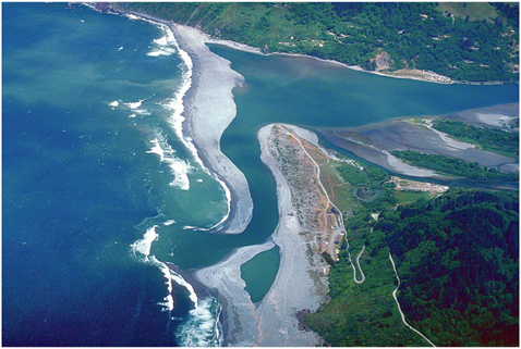
Mouth of the Klamath River in June. The sandbar nearly blocking the mouth of the river changes shape continuously. During winter high flows it would be far less prominent. Courtesy of the US Army Corps of Engineers
In addition to meandering stream channels, rivers running through alluvial valleys commonly have clearly defined floodplains with riparian vegetation. As the name implies, floodplains are areas that are inundated by water during floods; vegetation comprising a river’s riparian zone is generally adapted to the frequency of flooding, which varies relative to its distance from and height above the channel. Trees such as willows, alders, and cottonwoods may be able to withstand, and in some cases require, regular annual flooding to populate the floodplain near the river itself. Other trees with lower tolerance for flooding, including ash, maple, and some types of oak, may be present in the floodplain at greater distances from and heights above the stream channel.
The inundation of floodplains has other important implications for river ecosystems. Water spilling onto a floodplain moves much slower than water in a river channel. As a result, very fine sediment (or silt) in the water has the opportunity to settle on the floodplain. This silt contains nutrients that support aquatic plants and animals, so floodplains provide very productive habitat for native fish rearing, and they make productive farmland. The largest trees usually grow in the deep, rich, well-watered soil of floodplains. Today we see the permanent use of floodplains by agriculture throughout California: over 90 percent of floodplain habitat in the Central Valley has been converted to agriculture. There are now attempts to restore floodplains to their original periodic flooding pattern to help recover salmon and other native species.
The large amounts of sediment gathered from confined reaches of a stream are often too great to continue moving downstream once the stream reaches an alluvial valley; as a result, sediment builds up and forms an alluvial fan, so named because it tends to be fan shaped. It is highest near the stream at the base of the mountain slopes and gets lower moving away from the channel and into the valley.
ESTUARIES
An estuary is a semi-enclosed mixing zone where a river meets the ocean. From a chemical perspective, estuaries tend to have a lower concentration of salt water than the ocean, allowing many organisms in estuaries to be either primarily salt-water dwelling or primarily freshwater dwelling but capable of tolerating both. Some organisms in estuaries, such as pickleweed, are specialized to the moderate salinity found in neither freshwater rivers nor the ocean. You can taste the salt in pickleweed if you take a bite. Nutrient inputs from land and constant mixing by tides make estuaries among the most productive of aquatic ecosystems. In an estuary you can see a mix of wildlife from the ocean, the river, and the terrestrial habitat. River otters and mergansers mix with seals and pelicans as osprey circle overhead.
While many lakes and rivers are eutrophic, the ocean is generally considered oligotrophic; in fact, the absence of nutrients in the ocean is a primary reason why the ocean appears to be blue. Alpine lakes, like Lake Tahoe, Donner Lake, and Convict Lake, are blue because they are oligotrophic. Estuaries are generally not blue. The brown and green is as much a result of biological production as it is of the silt and sediment the river carries to the ocean. Although oceans in general are oligotrophic, the nearshore ocean off of California is enriched by upwelling. Upwelling happens when deep currents rise to the surface and bring up nutrients from the deep that support rich aquatic food chains including fish, birds, and mammals.

Gualala estuary, Mendocino County. The meandering course of the Gualala River estuary is the mixing zone for freshwater from the river and salt water from the ocean. Photo © 2002 P.T. Nunn
The dynamics of salinity in estuaries can vary according to several factors. The tides affect salt concentrations at any given point throughout the day. At high tide, estuaries tend to be more saline because oceans force salt water up the estuary and may even push back freshwater to a location farther inland. During low tide, freshwater can extend farther toward the ocean, providing the nutrients and other matter from the watershed to the estuary. The salinity of estuaries also varies seasonally. During periods of higher river flow, such as the California wet season, estuaries may become dominated by freshwater and silt delivered after storm events. The salinity of a particular location in the estuary may also vary with depth: because salt water is more dense than freshwater, it may settle below freshwater and create a vertical salinity gradient. Therefore, the species that inhabit estuaries must be able to tolerate a wide range of salinity.
Some estuaries are marked by deposition of large amounts of sediment and referred to as deltas. Deltas are formed by processes similar to those that make alluvial fans: large amounts of sediment are carried to a point where they can no longer be transported, resulting in a depositional formation shaped like the Greek letter delta, which is a triangle. The amount of material a stream carries depends on its speed and volume. When its speed drops to zero on entering a lake or estuary, its carrying capacity disappears and the sediments are deposited immediately.
INTERTIDAL ZONE
As rivers reach the ocean, whether by passing through an estuary or by falling down from a coastal bluff, the freshwater of the river merges with the salt water of the ocean. All along the California coast, from Mexico to Oregon, the environment nearest the shore is called the intertidal zone. California’s is strikingly beautiful, composed of over 3,000 miles of tidal shoreline, including beaches, piers, bluffs, rocky coves, ports, and harbors. California residents have a long history of fighting for public access, so today we can all enjoy much of our coastline. The vast majority of Californians live within 30 miles of the coast, and billions of dollars of economic activity depends on coastal resources, including tourism, recreation, fishing, shipping, and commercial and residential development.
The intertidal zone is characterized by high energy. Anyone who has visited the seashore along California’s Pacific coast will be familiar with this idea. Waves constantly break upon the shore, whether on a sandy beach or a rocky headland. Waves pound the shore delivering energy continuously. This pounding is one of the defining features of the intertidal zone, and all organisms living in the intertidal zone must adapt to it, from sea stars to urchins to anemones. Two common adaptations are a hard exoskeleton (also known as a shell) and the ability to adhere to rocks.
High energy has both positive and negative attributes. Waves may carry sand or rocks which erode or crush the shells of even well-protected organisms such as whelks. Waves also bring a fresh supply of highly oxygenated water which may also be high in nutrients. The intertidal environment can be very harsh. The costs (dangers) of life in the intertidal zone are great, but these rich environments are filled with food, making it worthwhile for species to inhabit these areas and adapt to the forces of nature.
The second physical factor that characterizes the intertidal zone is the rise and fall of the tides. The moon orbits the Earth, and the Earth orbits the sun, and the gravitational tug of the moon and sun causes two bulges in the planet’s oceans, or its hydrosphere. As the Earth spins through its 24-hour rotational cycle, any point on the Earth passes through these bulges twice each day. The result is the rise and fall of tides. The effect of rising and falling water levels on organisms living in the intertidal zone is intense. They must adapt to life underwater and to life exposed to dry air and full sun! Intertidal organisms must be both aquatic and terrestrial! They may be attacked by aquatic and terrestrial predators, round stingrays and raccoons! The other limit tidal cycles impose on intertidal organisms is that their food source may be missing for half the day! Many intertidal organisms are filter feeders. They stretch a web or net that floats in the water and traps nutrients, or they pump water through their body cavities like the Pacific razor clam and filter out nutrients inside their shells. In either case, when the organisms are exposed to air rather than to water, no feeding is possible.
The shoreline of California is rich in habitat diversity. A couple of factors that help naturalists to see the distinctions in seashore habitat are substrate and position (depth). Substrate refers to the physical composition of the shore. It may vary from fine mud in an intertidal estuary, to coarse sand on a sandy beach, to cobbles or boulders, to bedrock on exposed headlands, and it may include combinations of these. The group of organisms that inhabits mudflats in an estuary is almost completely different from the group that lives on rocky cliffs exposed to the tides. Tidal zone on the shore, relative to the tide elevation, refers to water depth. Tidal flux refers to the difference in water level between high tide and low tide (high tide level minus low tide level, typically measured in feet). If the tidal flux is 1 foot and the tidal cycle takes 12 hours (to go from high tide to low tide to high tide), the point highest on the shore is exposed for about 11 hours and the lowest point may be exposed for only a few minutes. Positions are often described using terms like spray zone (splash zone), upper intertidal zone, middle intertidal zone, lower intertidal zone, and subtidal zone.
The intertidal zone is a place of fascination and wonder, with organisms that appear to our terrestrial eyes both bizarre and beautiful. If you spend time in the intertidal zone, you may see a clam spit a jet of water 3 feet in the air; have an anemone grab your finger with mobile, Velcro-like tentacles; or come across the sea clown nudibranch, a white “sea slug” with red bumps and projections that looks ready for use in the Star Wars movies. The intertidal zone provides multiple ecosystem functions, including foraging and nesting habitat for birds and mating sites for elephant seals. This zone is also highly vulnerable to damage from oil spills, invasive species, and pollution, and it will be among the most affected by climate change as sea levels rise.
WETLANDS
Wetlands are transitional zones between land and water that are inundated with water periodically. Among the several types of wetlands are marshes, bogs, vernal pools, swamps, baylands, salt marsh, and riparian areas. Keep in mind that not all wetlands are freshwater. Some have high salt concentrations and support an entirely different suite of species, such as shrimp, mollusks, and pickleweed. A large number of native aquatic plants can be observed in wetlands. Pond lilies, cattails, sedges, bulrush, and arrowhead are a few examples. On a rainy day or spring evening it’s hard to ignore the loud call of California tree frogs coming from vernal pools and wetlands. In addition to frogs, other amphibians and also reptiles and waterfowl depend on wetlands. Prior to the conversion of most of California’s wetlands, there were herds of elk, flocks of birds that darkened the sky, and grizzly bears along the shores, and mussels, oysters, salmon, and sea otters were abundant in the water.
Wetlands provide the following ecosystem functions, processes, and services, as identified by the California Resources Agency:
Biological diversity: Wetlands provide important habitat for diverse communities of plants and animals, including over 50 percent of the federally listed threatened or endangered species in California.
Waterfowl habitat: Wetlands provide the principal habitat for migratory waterfowl (birds associated with water). California wetlands provide critical wintering habitat for millions of waterfowl migrating along the Pacific Flyway, which extends from Canada to Mexico.
Fisheries: Wetlands provide spawning and rearing habitats and food supply that supports both freshwater and marine fisheries.
Flood control: Wetlands detain flood flows, reducing the size and destructiveness of floods.
Water quality: Wetlands absorb and filter pollutants that could otherwise degrade groundwater or the water quality of rivers, lakes, and estuaries.
Groundwater recharge: Some wetlands recharge aquifers that provide urban and agricultural water supplies.
Recreation: Wetlands support a multi-million-dollar fishing, hunting, and outdoor recreation industry nationwide.
Despite these benefits, wetlands in California have been under pressure for many years. Historically, wetlands were viewed as dumping grounds and pest-ridden bogs to be drained, filled, and developed. For example, the San Francisco Estuary, the largest estuary on the West Coast, has lost nearly 97 percent of its historic wetlands and is one of the most invaded estuaries in North America. Like the intertidal zone, estuaries and other wetlands are vulnerable to rising sea levels, invasive species, nonpoint source pollution, and conflicts over water use and development.
CALIFORNIA’S LAKES
Lakes support a myriad of plant and animal species which mostly can be found in the littoral zone. The littoral zone is found at the top of a lake or pond and receives the most sunlight. Thanks to the energy from the sun, this zone can support a diverse biological community, including several species of algae (like diatoms), rooted and floating aquatic plants, grazing snails, clams, insects, crustaceans, fish, and amphibians. Dragonflies and midge eggs and larvae hang out here. Many of these species are important foods for turtles, snakes, and ducks.
California has some of the most unusual lakes in North America. Lake Tahoe, nestled near the crest of the Sierra Nevada, is the tenth deepest lake in the world and the second deepest in the United States. It is famed for its blueness, clarity, and alpine surroundings. Since 1959, Lake Tahoe has lost one-third of its remarkable transparency, and algal growth has increased by about 5 percent per year. Small particles of dust and sediment remain suspended in the water column for years, adding to the gradual but relentless transparency loss. Air pollution is a factor; nitrogen pollution of the lake from atmospheric deposition is greater than from stream water input! These changes have resulted in fewer native fish and an increase in exotic fish that can tolerate warmer and more polluted waters. Warming of Lake Tahoe due to surrounding land use as well as climate change presents a real threat to this unusual ecosystem. There is, however, growing public understanding of the value of this unique natural resource and a desire to protect the lake from further degradation.

Lake Tahoe, a unique alpine lake, sits at 6,225 feet altitude and is 1,645 feet deep. Photo by Adina Merenlender
CALIFORNIA’S FRESHWATER FISH
California’s large size, complex topography, and geographic variability have given rise to a diverse assemblage of native freshwater fish species, many of which are endemic to (occurring only in) the state. A total of 129 native freshwater fish taxa are recognized in California. California has both anadromous fish, such as salmon and lamprey that migrate long distances between marine and freshwater environments, and resident fish species that thrive in isolated desert springs, intermittent streams, and alkaline lakes. However, in comparison to rivers of the eastern United States, rivers in California support a smaller number of fish species. This is a consequence of the harsh environment in which California’s fish fauna evolved. The region has been subject to dramatic climate variation, including periods of glaciation and prolonged droughts. On an annual basis, streams in California fluctuate considerably from raging torrents in the wet season to dry or low-flowing trickles in the dry season. The species that have persisted demonstrate a range of local adaptations to thrive under these variable and often stressful conditions. For example, several species of pupfish persist in the few streams and pools found in California’s southeastern deserts, despite extreme water temperature and salinity levels. Thus, while relatively low in species richness (the total number of species), there is high diversity in morphology, behavior, and life history patterns in California’s fish fauna.
The transformation of California’s landscape throughout the nineteenth and twentieth centuries from mining, farming, and population growth has led to dramatic declines in freshwater fish populations. About 83 percent of California’s native freshwater fish species are extinct or endangered. The decline in native fish fauna has been caused by a wide range of human activities, including dams, water diversion, habitat modification, and introduction of nonnative species. Many of California’s rivers have been dammed or diverted. Dams disrupt connectivity within river networks, prevent the migration of salmon, and isolate fish populations above dams. Dams and diversions also alter the natural flow regime of rivers, reducing or eliminating peak flows, artificially enhancing summer flows, and changing cold-water rivers to rivers with warm-water conditions.
The loss and modification of freshwater habitat is another challenge to California fish fauna. The alterations to river corridors by land-use conversion, flood protection infrastructure, and riparian vegetation removal have altered habitats and natural ecosystem processes that native fish depend on. The Sacramento-San Joaquin Delta was once an enormous tule marsh with meandering rivers providing excellent habitat for rearing juvenile salmon and other native fish. It has been largely drained for farmlands protected by levees along dredged river channels. The Los Angeles River now flows for 50 miles within a concretelined channel. Virtually all forested watersheds in Northern California have been altered by massive sediment runoff caused by logging and hydraulic mining.
At least 50 nonnative freshwater fish species have been introduced in California and have had widespread negative effects on the state’s native fish through hybridization, predation, competition, and disease. Most introductions of nonnative fish were deliberate attempts to improve sportfishing or aquaculture, although accidental introductions of aquarium fish have occurred. The introduction of fish and invertebrates from the ballast water in cargo ships is a growing problem, and many refer to the San Francisco Bay as the “most invaded estuary in the world.” The success of introduced aquatic species in California is associated with modifications of aquatic habitats: nonnative species thrive in artificial reservoirs, drainage canals, and regulated rivers. A dramatic example is the Russian River. An interbasin hydroelectric diversion from the Eel River has changed the Russian River from a flashy, cold-water, intermittent stream with renowned steelhead runs to a perennial, warm-water river with abundant introduced warm-water species. The Russian used to dry up every summer! Its slow summer meander now makes it an inner-tuber’s paradise, although the fabled steelhead runs are on their last legs.
Based on current trends, much of California’s native fish fauna is likely to disappear in the next century. Because many of California’s fish are endemic, their extinction would represent a significant loss of global biodiversity. The need for freshwater ecosystem restoration and conservation planning is critical. The multifaceted and complex causes of fish population declines require that freshwater conservation measures be integrated with water management and land-use planning.
Mono Lake: An Important Case Study
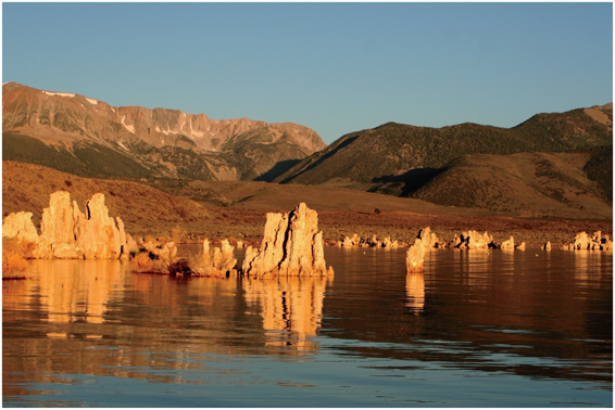
Tufa towers are exposed as a result of lake level lowering in Mono Lake. Mono is an alkali lake in a closed basin east of the Sierra Nevada. Photo by Brocken Inaglory
Mono Lake is a unique natural resource in California and the rest of the world. The lake evolved as a hydrologically closed basin, having no ocean outlet. Estimated to be 1 million years old, it is a remnant of the much larger ice-age Lake Russell. Early in the twentieth century, the City of Los Angeles bought up vast tracts of land with their riparian water rights — which allow use of the stream’s water on adjoining land — in the Owens Valley and the Mono Basin, which lies north of the valley. In about 1913 the Los Angeles Department of Water and Power (LADWP) began exporting these waters for urban use via an aqueduct system to Southern California. While this project was certainly an engineering marvel and provided Los Angeles with high-quality, inexpensive water, it also led to the demise of agriculture and components of the natural ecosystem in the Owens Valley.
Owens Lake dried down as sections of the Owens River channel were left dry and tributary streams were dammed and diverted. Mono Lake was also altered as the level of Mono Lake dropped from an elevation of 6,417 feet to 6,372 feet — a decrease of approximately 45 feet. The iconic tufa towers of Mono Lake became highly visible only after lake levels dropped. The associated increased salinity threatened the productivity of the brine shrimp population and associated phytoplankton. In addition, the drop in lake levels caused the loss of the hard-bottom habitat that is critical for the alkali fly. Mono Lake’s brine shrimp and alkali flies are critical food resources for many migratory and breeding birds such as the California gull and snowy plover.
The environmental community recognized the deterioration in Mono Lake and the surrounding areas and worked together to stop this legal diversion of water by Los Angeles. Prompted in 1976 by student research findings showing severe impacts of water diversions on the Mono Basin ecosystem, students, scientists, and other conservation-minded individuals undertook a massive, grassroots effort, “Save Mono Lake.” Litigation ensued in the form of suits filed under the Public Trust Doctrine (in 1979) and the California Fish and Game Code (in 1985).
After many years in court and the establishment of the region as the Mono Lake National Scenic Area under congressional directive, the State Water Resources Control Board in September 1994 issued an order (Decision 1631) to reduce greatly LADWP’s diversions of water from the Mono Basin and restore the lake to an elevation of 6,392 feet, a level last seen in 1964. This level was a compromise that would achieve several, but not all, ecosystem health objectives.
Adapted from Deborah Elliot-Fiske, 1995. “Mono Lake Compromise: A Model for Conflict Resolution.” California Agriculture.
RIVERS TODAY
Over the past several thousand years, humans have changed rivers in many important ways. Natural river processes are seen as hurdles to human development; most notably, humans are averse to flooding and drought. To prevent flood damage, people build levees, usually earthen walls along riverbanks to prevent the river from spilling onto the floodplain. Levees disrupt the natural process of flooding and the deposition of sediment and nutrients on the floodplain, and they threaten the survival of organisms that depend on periodic inundation. Levees are not a permanent solution, and over time, levees degrade and break, especially during high-stream-flow events.
Dams provide more reliable protection from flooding than levees do. They have greater impact on natural ecological processes, as well. Rather than keeping water in the channel from spilling onto the floodplain, a dam prevents water from flowing into the channel altogether. In doing so, a dam completely alters the river’s natural flow regime, which the organisms living in it have adapted to. Changing a stream’s natural flow regime can change its shape, the type and size of sediment accumulating in the riverbed, the type of fish and other aquatic life that can be supported, and the type of plants found along the river. Like levees, dams are not permanent. Many dams in California are filling in with sediment and now store only a small volume of water, relative to their original capacity.
As patterns of floodplain land use have changed over time, dams have become increasingly important for preserving human settlements and infrastructure. An example is Folsom Dam, which regulates flow in the American River and protects the city of Sacramento from flooding. While providing flood protection, these dams alter the magnitude of high-flow events. Water stored behind dams can also be released at different times than would naturally occur, affecting the timing of flow. For example, if dams are also managed for agricultural purposes, as many dams in California now are, water may be stored in a reservoir behind the dam throughout the wet season, for release as needed by farmers in the dry season. Some large dams also have large diversion channels operated by irrigation districts to distribute water to farmers, such as the Friant-Kern and Madera Canals, which divert water from the San Joaquin River stored behind Friant Dam. Similar diversions are operated for municipal drinking water, as are the Coyote reservoir in Mendocino County, Hennessey reservoir in Napa County, and Hetch Hetchy reservoir in Yosemite National Park. Other dams function primarily for power generation, such as those on Iron Gate, Copco, and Boyle reservoirs on the Klamath River along the Oregon-California border.

Shasta Dam. Courtesy of the US Bureau of Reclamation
Once a vast tidal marsh, the Sacramento-San Joaquin Bay-Delta is now a key center of water supply linkages, transportation infrastructure, and agricultural productivity in California. Where the Sacramento and San Joaquin Rivers meet, the Bay-Delta begins, establishing the eastern boundary of the San Francisco Estuary, the West Coast’s largest estuary. The Bay-Delta provides drinking water for 25 million Californians, and it supports irrigation supplies for a $27 billion agricultural industry. The Bay-Delta harbors 57 major reclaimed islands, 1,100 miles of levees, and hundreds of thousands of acres of marshes, mudflats, and farmland, making the entire system hydraulically, ecologically, economically, and socially complex. Land subsidence, sea level rise, earthquake risk, development, and ecosystem degradation now threaten the benefits the Delta provides.
More than 700 plant and animal species, some unique to this system, are dependent on the Bay-Delta. For avid bird-watchers this extensive estuary provides ideal viewing of waterfowl species, and many species stop to feed and rest as they pass along the Pacific Flyway. The Delta once supported some of the state’s largest fisheries, and many people are working to bring back winter- and spring-run Chinook salmon (Oncorhynchus tshawytscha), Central Valley steelhead (Oncorhynchus mykiss irideus), delta smelt (Hypomesus transpacificus), Sacramento splittail (Pogonichthys macrolepidotus), and southern green sturgeon (Acipenser medirostris). Invasive species now pose a threat to native populations in the Bay-Delta, however, as the estuary has experienced the arrival of more than 250 alien aquatic and plant species.
Management in the Bay-Delta traditionally addressed a multitude of purposes, including water supply, flood control, irrigation, power production, and navigation. The federal Central Valley Project and State Water Project comprise the two major California water development systems that use dams and canals to store and distribute water, generally from Northern California sources to Southern California cities and San Joaquin Valley farmers. California’s 2009 Delta Reform Act requires future water management policy to address newly coequal goals: to improve water supply reliability and to protect, restore, and enhance the Delta ecosystem. Today’s efforts to restore Bay-Delta ecology require large multiagency coordinated planning efforts. Some have proposed bold plans for a peripheral canal, which would ship water around the Delta from the Sacramento River to the southern part of the state. If implemented properly (i.e., with no net increase in water diversion), the peripheral canal could increase flow conditions in the Delta, which would benefit some endangered species. Changes in salinity levels in the Bay-Delta resulting from management decisions for a new canal might negatively affect biota and agricultural uses, however, so the peripheral canal proposal is controversial. Still, the peripheral canal debate highlights the need for long-term planning and policy setting for the region and for the state.
In addition to the dozens of large dams in California that store water for irrigation, drinking, and power generation, thousands of small reservoirs speckle the California landscape. Small reservoirs are commonly designed to supply a landowner or property manager with a supply of water for that given property, removing the need for reliance on a water agency or irrigation district. Many such reservoirs are located on small streams, first order or even smaller. In California, these streams generally flow during the wet season and flow very little, if at all, during the dry season. Because they are designed for an individual property, they are generally composed of earthen fill and do not have capacity to release water until they are filled, at which time they overflow into the channel.
Because it stores a small amount of water relative to the overall discharge of a larger drainage network and is on a small stream, a small reservoir on a headwater stream may not have as much adverse impact to stream processes as a dam on a larger channel farther downstream. But several small reservoirs operating together may have substantial cumulative effects, causing a greater impact than a single reservoir could have alone. Together, they may withhold enough water to significantly reduce the discharge in a creek that salmon or steelhead need for spawning and rearing. The abundant small dams on tiny headwater streams also alter habitat by providing water sources in an otherwise summer-dry environment. Invasive species like feral pigs and bullfrogs are aided greatly by these water sources.
CALIFORNIA WATER MANAGEMENT AND LAW
The management of water resources is one of the greatest challenges facing officials in the state of California today: we must meet the demands of a growing population and a sizable agricultural economy while maintaining the sustainability of aquatic ecosystems. Today, efforts are underway to ensure that the means to acquire water to meet human needs preserve both the quality and quantity of stream ecosystems across the state. Adding to the problem are uncertainties surrounding future climate change that may change the timing and amount of water availability as well as result in increased demand.
Since it became a state in 1850, California has granted people the right to take water from streams for beneficial uses. The right to divert water from surface water bodies is overseen by a complex system of rules that combines two basic doctrines of water rights: the riparian doctrine and the doctrine of prior appropriation, which together are called the California doctrine. Under the doctrine of prior appropriation, water users follow a prioritization of diversion according to seniority; under the riparian doctrine, water users divert as needed, in proportion to what is available during times of shortage. The right of people to divert water from streams is overseen by the State Water Resources Control Board (SWRCB). Though the SWRCB has had the power to oversee diversion of stream flow since the 1910s, it does not have the ability to oversee the pumping of groundwater, except in cases where groundwater is in clear and definite connection with surface water. Areas not served by irrigation districts rely more heavily on riparian and appropriative doctrines because, in addition to groundwater resources that may or may not be available, they provide water security for residential and agricultural uses.
The criteria used to determine whether a water right can be granted have changed over the past few decades. Many of these changes came about because the law now includes ecosystem functions as a beneficial use of water equal to other uses, such as for agriculture and cities. For example, water needed to provide habitat for fish is now considered a beneficial use. This means that in some cases water rights can be exercised only if enough water is left in the stream to provide conditions necessary for fish to survive. Some of these cases are further complicated by federal laws to protect endangered species, which provide additional protections of specific instream flow conditions. In the 1980s, the California Supreme Court also decided that the State Water Resources Control Board had to consider the public interest in preserving natural resources when granting water rights permits. The legal recognition of public trust resources was the foundation for restoring water to Mono Lake (see Mono Lake: An Important Case Study).
CHALLENGES FOR THE FUTURE: POPULATION GROWTH AND CLIMATE CHANGE
One of the largest questions regarding California water is how the dynamics of stream processes will change as Earth’s climate changes and as population grows. As our population grows, our need for water will increase. California’s population is estimated to grow from 37 million to more than 50 million by 2050, leading to increased demand for urban and agricultural water supply. Population growth will require an additional 5.9 to 7.4 million acre-feet of water per year by 2030, if agricultural use remains constant. Current sources of water are not secure; the Colorado River supply for California is expected to decline and “environmental water uses” are likely to continue to compete with domestic and agricultural uses. There are several options available to help balance water use with supply in California in the immediate future. These include urban conservation measures, increased efficiency in agriculture, underground storage in groundwater basins, increased surface storage, recycling of municipal water, desalination, and reduction in losses from canals and conveyance.
There is substantial uncertainty regarding how climate change will affect hydrology in California. California encompasses many climates, from the very wet temperate forests of the north coastal ranges to the arid deserts of the southeast. How warmer temperatures will affect rainfall and stream flow patterns in each of these areas is difficult to predict. However, climatologists and hydrologists generally agree that we can expect greater variability and more extreme hydrologic events over time, including larger floods and more severe droughts. Greater climate variability has implications for aquatic biota, such as riparian communities dependent on floodplain processes which are structured by the frequency and depth of inundation. Water quality may also be affected by global climate change because of more intense rainfall events and increases in runoff and sedimentation.
Despite uncertainty, scientists generally agree that warmer temperatures will have major impacts on California’s water supply. Warmer temperatures will increase the percentage of precipitation that occurs as rain rather than as snow. More rainfall and less snow will shift the timing of flows, from snowmelt yielding water from April through September to rain events from November through March. In this case, reservoirs would fill earlier and have to release water during the wet season. Managers would have to release water before the growing season or early in the growing season. Those releases would no longer be replenished by snowmelt. Even if the same amount of annual discharge from the mountains occurs, a shift from snowmelt to rain with anticipated climate change is likely to reduce the amount of water available for agriculture in much of the state.
In recent years, discussions about how to adapt to meet our future water needs have become more urgent. New dams have been suggested; some of these would occupy sites that have been proposed in the past, and others would be in new locations previously unplanned. Still others call for reducing water use and increasing efficiency by reconstructing decades-old leaky channels and shifting from thirsty crops to those that need less water or produce larger financial benefit with smaller yields.
How California deals with these pressures, and others as yet unanticipated, remains to be seen. Just as it is uncertain precisely how flow regime will change with changes in climate, the direction of the dialogue for finding solutions to these issues remains uncertain. One thing that Californians can count on is that water will remain at the center of economic, ecological, social, and policy discussions far into the future.
Explore!
VISIT A PERMANENT OR TEMPORARY WETLAND
Visit a wetland or a vernal pool and notice the changes in the plant communities near and far from the wetland. Document changes that you think might have occurred since European settlement. Look at an aerial photograph and in the field to see if you can determine whether the size, shape, or extent of the wetland has changed over time. For example, have some areas been filled for development? You can find wetlands by accessing the National Wetlands Inventory at http://www.fws.gov/nwi/.
VISIT A WASTE WATER TREATMENT PLANT THAT USES PONDS FOR DECOMPOSITION
In addition to providing information about innovative new approaches to wastewater treatment and wetland creation, these ponds are almost always excellent places to go birding. Cities with these ponds include Arcata, Ukiah, Petaluma, Davis, Fresno, San Rafael, Santa Maria, and Ventura. Please note that these ponds are run by municipal agencies and vary in their level of preparedness for visitors. Call ahead to check.
VISIT THE BAY MODEL
The Bay Model is a three-dimensional working hydraulic model of San Francisco Bay and the Sacramento-San Joaquin River Delta. It is administered by the Army Corps of Engineers and located in Sausalito, across the Golden Gate Bridge from San Francisco. Find out more about it at www.spn.usace.army.mil/bmvc/.
HELP WITH WATER QUALITY MONITORING
Check with local stream restoration groups or watershed groups for opportunities to sample water quality. Some groups have a “first flush” event that collects water quality information during the first major rain event each fall.
BUILD YOUR OWN HESTER-DENDY AND SAMPLE BENTHIC MACROINVERTEBRATES
This is so much fun, you won’t believe it yields important results. With a small amount of instruction, you can learn to identify and sample benthic macroinvertebrates, which provide key information about water quality. As with other volunteer water quality sampling, check with local stream groups for information.
A Hester-Dendy is a simple piece of equipment you can build to catch macroinvertebrates for water sampling. Adopt-A-Stream has instructions on making one at www.adopt-a-stream.org/pdf/monitoring_tools/the_hestner.pdf. Utah State University Extension, http://extension.usu.edu/waterquality/files/uploads/PDF/Making%20_equipment.pdf, has nice information about building all kinds of simple water-monitoring equipment.
EXPLORE WHERE YOUR DRINKING WATER COMES FROM
Describe how drinking water arrives in your house, and identify at least two social or political positions on the issues that arise from that process. Make an argument in favor of and against each position. The Water Education Foundation’s website, “Where does my water come from?” at www.water-ed.org/watersources, is a nice place to start.