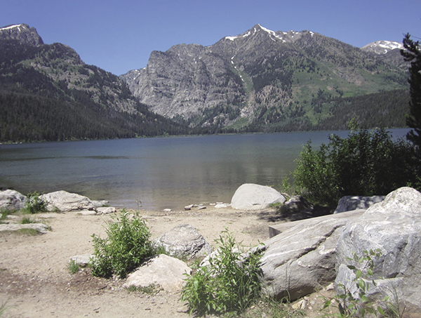
Phelp’s Lake, Albright Peak
1 Phelps Lake
Description: A short day hike or easy overnighter to a low-elevation lake
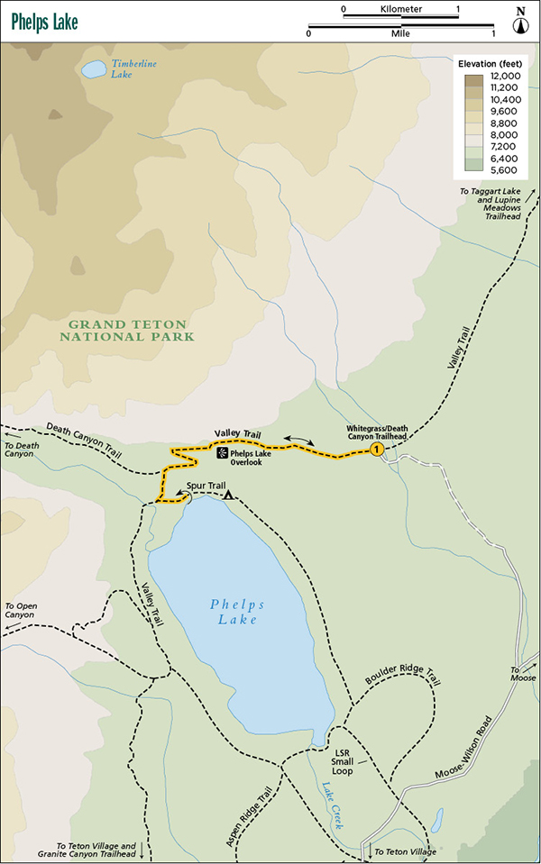
Start: Whitegrass/Death Canyon Trailhead
Total distance: 4.0 miles out and back
Best season: July through Sept
Maps: Earthwalk Press Grand Teton map; National Park Service handout map
Finding the trailhead: The trailhead is called Whitegrass on some maps and signs and Death Canyon on others, but it’s the same place. From Jackson, take WY 22 west for 6 miles to the Moose-Wilson Road junction, just before entering the small town of Wilson. Turn right (north) here, go past Teton Village into the park, and continue on this road (which turns to gravel) until you see the Death Canyon Trailhead turnoff on your left (west), 11.5 miles from WY 22. If you’re coming from the north, the trailhead is 3.1 miles south of the Moose Visitor Center on Moose-Wilson Road, which turns south right across from the visitor center and doesn’t go through the entrance station. After turning off Moose-Wilson Road, drive 1.6 miles to the actual trailhead, the last mile of which is an unpaved road that can get rough. The park service recommends a high-clearance vehicle for this road. The trailhead has toilet facilities and a fairly large parking area, but this trailhead is so popular that it’s often full, especially at midday. Trailhead GPS: 43.656039 / -110.781367
The Hike
Phelps Lake, a low-elevation lake, is one of the most popular destinations in the park. It’s an easy day outing, but also an ideal place for the new backpacker to try that first night in the wilderness.
Phelps Lake is on the Valley Trail, which goes from Teton Village to the Lupine Meadows Trailhead. You can reach it from several trailheads, but the shortest, most popular route starts at the Death Canyon Trailhead (also called Whitegrass Trailhead on some maps and signs).
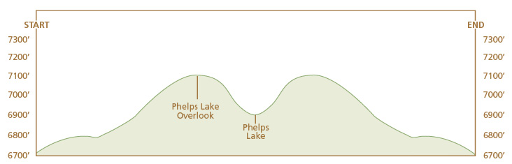
Only 0.1 mile after leaving the trailhead parking lot, you reach the first junction with the Valley Trail. Go left (southwest) and hike 0.8 mile up a gradual hill to the Phelps Lake Overlook, where you get a nice view of the lake and the valley beyond.
Phelp’s Lake, Albright Peak
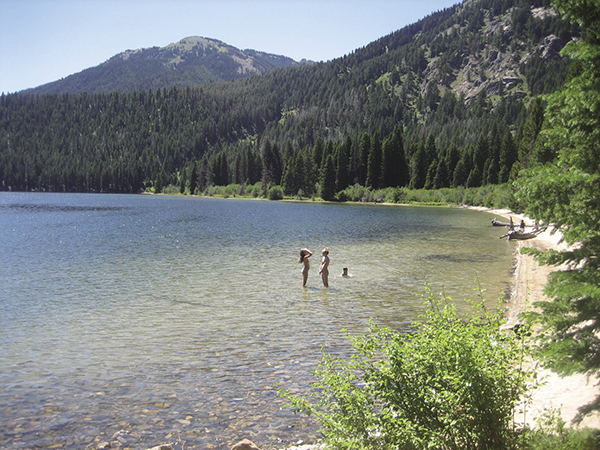
Enjoying Phelps Lake.
From here it’s a steep downhill on switchbacks to Phelps Lake, with a left (south) turn at the junction with the trail up Death Canyon. If you’re camping, take a left on a spur trail just as you get to the lake instead of following the Valley Trail along the west side of the lake.
The well-maintained trail goes through mature forest most of the way, with one brush-covered open slope above Phelps Lake. Watch for moose and black bears, which are commonly seen around the lake. Enjoy some fishing (with a Wyoming state fishing license) for brook, cutthroat, and lake trout. After your stay at Phelps Lake, retrace your steps back to the trailhead, keeping in mind that the way back involves a fairly steep climb up to the Phelps Lake Overlook.
Camping: Phelps Lake has three excellent campsites. As you approach the lake, watch for a junction with a trail going to the left (east) to the campsites. All three are on the lake’s north shore with a good view of the lake, fire pits, and room for two tents. Two share a food storage box; one has its own. The campsites are out of sight of the main trail, but they are fairly close. Please talk softly to respect the privacy of others. Campsite GPS: 43.652799 / -110.79865, 43.652406 / -110.797630, 43.65191 / -110.796900
Option: You can make this a shuttle by leaving a vehicle at the Granite Canyon Trailhead, which would make this a 6.1-mile hike.
Miles and Directions
0.0Whitegrass/Death Canyon Trailhead
0.1Junction with Valley Trail; turn left
0.9Phelps Lake Overlook
1.6Junction with Death Canyon Trail; turn left
2.0Phelps Lake; turn around and retrace your route
4.0Whitegrass/Death Canyon Trailhead