
Marion Lake. National Park Service
4 Marion Lake
Description: A long, hard day hike or moderate overnighter to a high-elevation lake
Start: Top of tram at Teton Village
Total distance: 14.7-mile lollipop loop
Best season: July through Sept
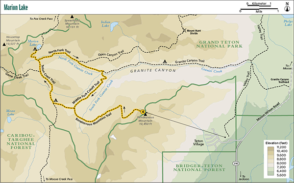
Maps: Earthwalk Press Grand Teton map; National Park Service handout map
Finding the trailhead: Take the tram behind the main ski lodge in Teton Village to the top of Rendezvous Mountain to start this hike. Teton Village is 12.5 miles northwest of Jackson. From Jackson, take WY 22 west for about 6 miles to the Moose-Wilson Road junction, just before the small town of Wilson. Turn right (north), go 6.5 miles, and turn left (west) into Teton Village. Park in the main ski lodge parking lot. Teton Village has restaurants, shopping, and toilet facilities in the lodge. Trailhead GPS: 43.587517 / -110.827183
The Hike
Marion Lake is a long day hike, but you can start it the easy way, going downhill, if you take the tram from Teton Village. You could hike 6.6 miles up to the top of 10,450-foot Rendezvous Mountain on the service road instead of taking the tram, but, obviously, that isn’t a popular option. The tram leaves every fifteen minutes 9 a.m. to 7:30 p.m. with a fee to go up but no fee to go down. The Marion Lake hike makes a nice two-day outing, with a pleasant overnight stay at one of the few mountain lakes in the park.
Be sure to take a map. This route has a lot of junctions, and one lapse in concentration could result in getting on the wrong trail. In August and September, this route can be dry, as several intermittent streams dry up, so carry plenty of water. Horses are not allowed on the first 3.9 miles of this trail.
After getting off the tram, hike down a steep ridgeline to the junction with the tram service road and the park boundary. Take this first leg of your trip slowly so you can soak in the incredible view of the Teton Range to the north—including Grand Teton peeping over the skyline—and the valley to the south.
Marion Lake. National Park Service
At the park boundary, turn right (west) and take one big switchback down the steep slope of Rendezvous Mountain into a bowl. You can see the trail heading up on the other side of the bowl. After the descent through some talus and subalpine vegetation, you move into spruce forest interspersed with large meadows. Most of the rest of the trail goes through this type of terrain.
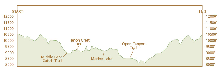
When you get to the next junction at Middle Fork Cutoff Trail, you can take the loop in either direction, but this hike describes the clockwise route, so take a left (west) at this junction and right (north) at the next two junctions at the Teton Crest Trail (to Moose Creek Pass) and Game Creek, until you drop down into the North Fork of Granite Creek below Marion Lake. From there, you are treated with a short but steep climb up to the lake.
Marion Lake is a little jewel tucked in the shadow of mighty Housetop Mountain and surrounded by wildflower-carpeted meadows. Even if you aren’t staying overnight, plan on spending some serious time at the lake. It’s too nice to view quickly and then abandon. But don’t dawdle too long. Unless you’re spending the night, you have to make it back to the tram before 7:30 p.m. to catch the last tram.
After a rest or lunch break or overnight stay at the lake, drop back down into the North Fork, but this time turn left (east) and go down the North Fork of Granite Creek. Most of this leg of the trip goes through a giant meadow on the north side of the stream. At the junction with the Open Canyon Trail to the Mount Hunt Divide, veer right (east) through an open forest to the Middle Fork Cutoff Trail. Turn right (south) and go through another huge meadow back to the Rendezvous Mountain Trail junction you passed earlier in your trip. From here go left (east) and retrace your steps back to the tram. Save some energy and water for the last pitch up to the tram. It can be a tough finish, especially on a hot day, to a great hike.
Camping: Marion Lake has three heavily used campsites with a good water source and nice views (although you can only see the lake from the first campsite and then just barely), with two raised tent pads each. You can also camp at the Middle Fork Camping Zone or the Upper Granite Canyon Camping Zone. Upper Granite has nicer campsites along the stream and good water sources. The Middle Fork campsites generally offer better views, but water can be scarce in many areas, especially in late August and September when intermittent streams dry up. Marion Lake has designated campsites, but the two camping zones allow you to find your own campsite.
Options: You can hike the loop in reverse, but you face a fairly steep climb coming out of the South Fork of Granite Creek. You can also hike out and back and cut 1.5 miles off the total distance.
Side trips: If you have the time, you can hike about a half mile up from Marion Lake to a gorgeous high-altitude plateau. You can also take a side trip (about 1.4 miles round-trip from Teton Crest Trail) over to Moose Creek Divide for a great view. The Game Creek Trail more or less ends at the park boundary. Officially it continues on, but it’s very difficult to follow. But the stunning view from the boundary, one of the grandest in the park, makes this a great out-and-back side trip.
Miles and Directions
0.0Top of the Teton Village Tram
0.4Junction with tram service road and park boundary; turn right
3.9Junction with Middle Fork Cutoff Trail; turn left
4.4Junction with Teton Crest Trail (to Moose Creek Pass); turn right
5.4Junction with Game Creek Trail; turn right
6.0Junction with North Fork Trail; turn left
6.6Marion Lake
7.2Junction with North Fork Trail; turn left
8.4Junction with Open Canyon Trail; turn right.
9.1Junction with Middle Fork Cutoff Trail; turn right
10.8Junction with Rendezvous Mountain Trail; turn left
13.9Junction with tram service road; turn left
14.7Top of Teton Village Tram