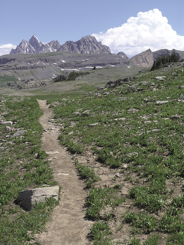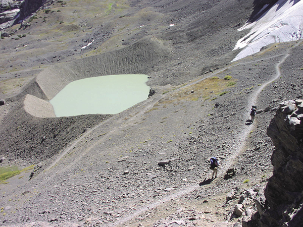
The incredibly scenic Teton Crest Trail. National Park Service
7 The Teton Crest
Description: It really doesn’t get much better than this, a truly spectacular backpacking adventure starting at 10,450 feet, definitely one of the best in North America
Start: Top of tram at Teton Village
Total distance: 35.4-mile shuttle
Best season: Aug through mid-Sept
Maps: Earthwalk Press Grand Teton map; National Park Service handout map
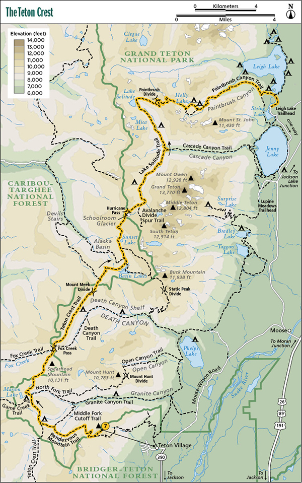
Finding the trailhead: For the shuttle, leave a vehicle at the Leigh Lake Trailhead at the String Lake Picnic Area (GPS: 43.784082 / -110.727354). To find this trailhead, take US 89 north of Jackson for 11.5 miles and turn left (west) at the Moose Junction. Drive past the Moose Visitor Center and through the entrance station (about a mile after turning off the highway). Follow this paved park road for another 9.7 miles from the entrance station to the Jenny Lake turnoff. Turn left (west) and drive 0.6 mile (follow the signs and take two right turns) to the String Lake Trailhead and 0.3 mile farther to the String Lake Picnic Area. The Leigh Lake Trailhead is in the northwest corner of the picnic area. From the north, drive 9.9 miles from the Jackson Lake Junction and turn right (west) at the Jenny Lake turnoff. There are toilet facilities in the picnic area at the Leigh Lake Trailhead.
To start the hike, take the tramway behind the main ski lodge in Teton Village to the top of Rendezvous Mountain. Teton Village is 12.5 miles northwest of Jackson. From Jackson, take WY 22 west for about 6 miles to the Moose-Wilson Road junction, just before the small town of Wilson. Turn right (north), go 6.5 miles, and turn left (west) into Teton Village. Park in the main ski lodge parking lot. Trailhead GPS: 43.587517 / -110.827183
Recommended itinerary: A five-night trip staying at:
The Hike
The Teton Crest is a long (at least three nights) shuttle hike with the incredible luxury of starting at 10,450 feet and ending at 6,875 feet, a net loss of 3,575 feet. That’s not to say, however, that there is no climbing. Quite to the contrary, you must sweat your way up three big climbs, including the two most famous in the park—Hurricane Pass and Paintbrush Divide. And, of course, you go by three stunning high-country lakes—Marion Lake, Lake Solitude, and Holly Lake. Lastly, you get the best mountain scenery possible, including several miles in the shadow of the Grand Teton.
What more could you want? Three more things: good weather, a week off, and the advanced physical conditioning necessary to enjoy it.
There aren’t many hikes that start out downhill, but if you take the tram from Teton Village, this can be one of them. As you stand at the main ski lodge in Teton Village, you have a tough choice. You can carry your backpack stuffed with six days of food and gas up 4,100 feet over 6.6 miles of constantly switchbacking service road or you can ride up the tram in ten minutes without breaking a sweat. Tough decision, eh?
Obviously, most people choose the tram, which leaves every fifteen minutes, 9 a.m. to 7:30 p.m. There’s a fee to go up, but no fee to go down.
On this trip, especially on the first day, keep your map out. This route has an unusually high number of junctions, and without carefully following the map you could end up on the wrong trail.
From the tram, hike down a steep ridgeline to the junction with the service road and the park boundary. Go slowly and savor the incredible view of the Teton Range to the north, including Grand Teton peeping over the skyline (you’ll be on the other side of it three days later), and the valley to the south.
At the park boundary, turn right (west) and take one big switchback down the steep slope of Rendezvous Mountain into a bowl. You can see the trail heading up on the other side of the bowl. After the descent through some talus and subalpine vegetation, you move into spruce forest interspersed with large meadows. You’ll stay in this type of terrain until Marion Lake, where you climb up to alpine country along the Teton Crest Trail.
In August and September, this route can be dry, as several intermittent streams dry up, so carry plenty of water. Horses are not allowed on the first 3.9 miles of this trail.
When you get to the next junction, take a left (west), then a right (north) at the next two junctions with trails to Moose Creek Pass and Game Creek, until you drop down into the North Fork of Granite Creek below Marion Lake. There you’re treated to a short but steep climb up to the lake.
Marion Lake is a little jewel tucked in the shadow of mighty Housetop Mountain and surrounded by wildflower-carpeted meadows, and it is a great choice for the first night out.
When you leave Marion Lake in the morning, you face a 0.4-mile climb up to the park boundary and an unnamed divide on the flanks of Housetop Mountain. Then, to Fox Creek Pass it’s mostly level, alpine hiking with spectacular views all around, especially of aptly named Spearhead Mountain off to the right (east).

The incredibly scenic Teton Crest Trail. National Park Service
Just before reaching Fox Creek Pass, you come to a confusing junction (no sign when we were there) with a trail going off to the left (west) down Fox Creek into the Jedediah Smith Wilderness. Turn right (north). Just over a small hill you’ll see Fox Creek Pass and the park boundary. At the pass, you can either go right (northeast) down Death Canyon or left (north); you want to go left and continue along the Teton Crest Trail on Death Canyon Shelf.
The next 11 miles—over Fox Creek Pass, along Death Canyon Shelf, up and down Mount Meek Divide, through Alaska Basin, and up Hurricane Pass—are the absolute essence of the Teton Range, the choicest of the choice for mountain scenery. I’ve been backpacking for more than forty years; this is definitely a truly memorable stretch of trail. I’m sure you’ll agree.
The Death Canyon Shelf is a flat bench on the east flanks of a series of awesome peaks—Fossil Mountain, Bannon Peak, Mount Jedediah Smith, and Mount Meek. To the east, you can look down Death Canyon all the way to Jackson Hole. The shelf is a great choice for the second night out. It’s exposed to weather, though, so be prepared, and water can be hard to find in September.
From Mount Meek Divide, you drop down into gorgeous Alaska Basin. Several small lakes dot the basin, along with a labyrinth of trails. All are distinct and well signed, however, so you should not have a problem finding your way past Basin Lakes and Sunset Lake and up to Hurricane Pass. And indeed, a hurricane-force wind almost blew us off the pass when we were there, so no problem figuring out how the name came to be.
From the pass you can see it all, including Grand Teton (and Middle and South Teton), Mount Moran to the north, and, right below you, Schoolroom Glacier. Unless the weather prohibits a long stay (as it did when I was there), spend some quality time on Hurricane Pass identifying all the peaks.
The trip from Marion Lake to Hurricane Pass might have been the best ever, but the section between the pass and Holly Lake rivals it for scenic beauty. The trail down Hurricane Pass is steep at the top but soon becomes a nicely switchbacked trail. If you have some extra time, set up camp near the top of the South Fork Cascade Camping Zone and take a side trip up toward Avalanche Divide for a close-up view of the three Tetons.
After a night along the South Fork of Cascade Creek, drop down to the junction with the main trail up Cascade Canyon. You could bail out at this point and go down to the west-shore boat dock on Jenny Lake, but if you do, you’ll miss Lake Solitude and the Paintbrush Divide, so go left (northwest) at this junction.
The trail up the North Fork of Cascade Creek is forested at first but soon breaks out into subalpine meadows and a virtual kaleidoscope of wildflowers. It’s 2.7 miles to Lake Solitude, but you probably want to set up your fourth camp somewhere near the top of the North Fork Cascade Camping Zone. It will only be a short walk up to Lake Solitude after camp has been set up. Lake Solitude is remote but sometimes not as quiet as it used to be. It’s now a popular destination, so don’t expect to have it to yourself.
After the fourth night below Lake Solitude, psych yourself up for the biggest hill of the trip, the 2.4 miles up to 10,700-foot Paintbrush Divide. The trail is in great shape, and when you stop to rest you have some great scenery to enjoy—Lake Solitude and Mica Lake below and Grand Teton to the southeast.
Paintbrush Divide might not be quite as awesome as Hurricane Pass, but it’s a very close second. After soaking up the scenery for a while, start down the divide into Paintbrush Canyon on one big switchback through a talus slope and, even in September, over some snowbanks clinging to this north-facing slope. In fact, it’s often dangerous to try this slope without an ice axe until August. Before you leave on this trip, be sure to quiz a ranger on the snow conditions on Paintbrush Divide. If an ice axe is recommended, be sure you know how to use it to rescue yourself if you fall. If this is beyond your capabilities, delay this trip until snow conditions improve.
If you’re doing a five-night trip, plan on Holly Lake for your last night in paradise. The junction is only 1.3 miles from the divide, but it’s another 0.3 mile uphill to the lake and about that far over to the campsites on the east end of the cirque containing Holly Lake.
After your night at Holly Lake, follow the rest of the cutoff trail left (east) from the lake. Rejoin the main trail down Paintbrush Canyon 0.4 mile from the lake and gradually drop out of the high country into the mature forest of the low country.
When you get to the junction with the String Lake Trail, go left (east) and hike a mere 0.7 mile to the bridge over the short stream between String Lake and Leigh Lake. Cross the bridge to the junction with the Leigh Lake Trail just on the other side of the bridge, turn right (south), and hike a super-flat 0.8 mile along String Lake back to the Leigh Lake Trailhead and String Lake Picnic Area parking lot, where you’re likely to feel somewhat disappointed to be ending a truly remarkable backpacking trip.
Camping: For the first night out, you have four choices. Marion Lake has three heavily used campsites and a good water source, nice views (although you can only see the lake from the first campsite and then just barely), and two raised tent pads each. Marion Lake may be the best choice for the first night out because it’s nicely located at 6.6 miles from the tram. Although not as convenient, you can also camp at the Middle Fork Camping Zone or the Upper Granite Canyon Camping Zone.

Hikers on Hurricane Pass on the Teton Crest Trail. National Park Service
Upper Granite has nicer campsites along the stream with good water sources. The Middle Fork campsites generally offer better views, but water can be scarce in many areas, especially in late August and September when intermittent streams dry up. Marion Lake has designated campsites, but the two camping zones allow you to find your own campsite. For the fourth choice, you can hike past Marion Lake and camp outside the park.
For the second night, you probably want to strive for the Death Canyon Shelf and the open camping zone with no designated campsites. Water is scarce on the south part of the shelf but adequately abundant from the midpoint on. The scenery from camp will be the best possible. There’s enough room to find privacy, and rest assured that the air-conditioning will be on.
If you’re trying to cover this route with four nights out, hike past the shelf and camp anywhere in Alaska Basin. This is outside the park, so NPS regulations don’t apply. However, be sure to walk softly and set up a no-trace camp in this fragile highland.
For the next night out, you can opt for either the South Fork Cascade or North Fork Cascade Camping Zones. Both areas have indicated sites, but you can camp anywhere in these areas. The indicated sites are nicely set up, however, so we can’t imagine wanting to find something new. All of these campsites (and there are plenty) are outstanding. The main issue is how far you want to go that day. The camping in the North Fork is probably even nicer than in the South Fork because most sites come with a stunning view of Grand Teton.
Holly Lake has three designated campsites about a quarter mile from the lake at the end of a trail that crosses the outlet on rocks and goes up on a slope above the lake. Campsite 3 is the most private. Surprisingly, the campsites do not have good views right from camp. Water is fairly accessible from all three sites, which have two tent pads each and a shared food storage box.
The Lower Paintbrush Canyon Camping Zone has nine indicated campsites strategically located on high points above the trail. Most are private (about 100 yards from the trail) but have only one tent pad (the park service plans to add more later). Some of them have a fairly long hike to water. Most of the campsites are five-star with a great view.
You can also camp in the Upper Paintbrush Camping Zone along the main trail below Holly Lake. This zone requires a camping permit different from the one for Holly Lake even though they aren’t far apart.
Options: This hike can be taken in reverse, but you face more climbing because at the end you will need to get up Rendezvous Mountain on foot. You can bail out and make the trip shorter by coming down Death Canyon or Cascade Canyon.
Side trips: If you have the time and energy (and enough granola bars!), try the side trips up to Static Peak Divide and Avalanche Divide.


Miles and Directions
0.0Top of the Teton Village Tram
0.4Junction with tram service road and park boundary
3.9Junction with Middle Fork Cutoff Trail
4.4Junction with Teton Crest Trail
5.4Junction with Game Creek Trail
6.0Junction with North Fork Trail
6.6Marion Lake
7.0Park boundary
8.8Junction with trail down Fox Creek
8.9Fox Creek Pass and junction with Death Canyon Trail
12.4Mount Meek Divide and park boundary
12.6Junction with trail to Devils Stairs
14.4Basin Lakes
14.6Junction with trail to Buck Mountain Pass
15.4Junction with second trail to Buck Mountain Pass
15.7Sunset Lake
17.4Hurricane Pass and Schoolroom Glacier
19.0Junction with trail to Avalanche Pass
22.5Junction with Cascade Canyon Trail
25.2Lake Solitude
27.6Paintbrush Divide
28.9Junction with spur trail to Holly Lake
29.2Holly Lake
29.7Return to main trail in Paintbrush Canyon
33.9Junction with String Lake Trail
34.6Junction with Leigh Lake Trail
35.4Leigh Lake Trailhead and String Lake Picnic Area