
Leigh Lake. National Park Service
8 Leigh Lake
Description: A really flat, really scenic day hike or easy overnighter along the shoreline of two lakes
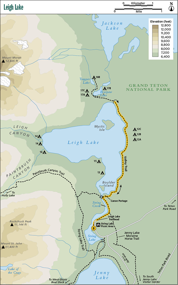
Start: Leigh Lake Trailhead at the String Lake Picnic Area
Total distance: 5.6 miles out and back
Best season: May through Sept
Maps: Earthwalk Press Grand Teton map; National Park Service handout map
Finding the trailhead: Take US 89 north of Jackson for 11.5 miles and turn left (west) at the Moose Junction. Drive past the Moose Visitor Center and through the entrance station (about a mile after turning off the highway). Follow this paved park road for another 9.7 miles from the entrance station to the Jenny Lake turnoff. Turn left (west) here and drive 0.6 mile (follow the signs and take two right turns) to the String Lake Trailhead and 0.3 mile farther, the String Lake Picnic Area. From the north, drive 9.9 miles from the Jackson Lake Junction and turn right (west) at the Jenny Lake turnoff. Park in the large parking lot at the picnic area, which has toilet facilities. The Leigh Lake Trailhead is in the northwest corner of the picnic area. Trailhead GPS: 43.789162 / -110.731655
Leigh Lake. National Park Service
The Hike
Although Leigh Lake is a nice hike in July, August, and September, it’s also a good choice for May or June. The snow leaves this area much sooner than the high country. The scenery is unbeatable with Mount Moran and Rockchuck Peak looming above Leigh Lake and the narrow Paintbrush and Leigh Canyons slicing into the Teton Range above the west shore on each side of Mount Woodring, the high peak between Moran and Rockchuck.
The trail is in terrific shape (often double wide), and sandy beaches provide inviting rest spots along both String Lake and Leigh Lake. In addition to being one of the best day hikes in the park, Leigh Lake also provides a wonderful choice for an easy overnighter, ideal for the beginning backpacker or a family with children wanting to experience that first night in the wilderness.
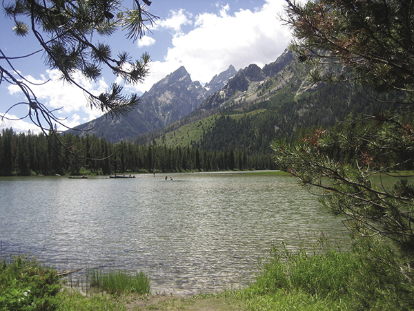
A view of String Lake from the Leigh Lake Trail.
Halfway along String Lake, a horse trail comes in from the right (east). From this point on, don’t be surprised to see a string of horses with park visitors getting their first horse-riding experience. At the end of String Lake, go right (north) at the junction, onto the Valley Trail. At this point you see a portage trail for people hauling their canoes up to Leigh Lake. The foot trail angles off to the right of the portage trail.
After a short, 0.2-mile walk through lodgepole pines, you get your first view of enormous Leigh Lake, a 250-foot-deep lake formed by the glaciers that once flowed out of Leigh and Paintbrush Canyons. The trail closely follows the shoreline, with Mount Moran providing the scenic backdrop. About halfway along Leigh Lake, you pass by the east-shore campsites, complete with sandy beaches and world-class vistas. The end of the lake is about 0.4 mile past the campsites. You can turn around at the campsites or the end of the lake.
Camping: The campsites on the east shore of Leigh Lake are extraordinarily nice. You get a spectacular view of Mount Moran and the Teton Range right from the food areas. Each campsite has a fire pit, two or three good tent sites, and a metal bear box for storing food and garbage. Since the three campsites are on the lakeshore, water is readily accessible. The first of the three is a group site. The only knock on these sites is that the trail goes right by them, sacrificing privacy. Campsite GPS: Campsite 12A, 43.813 / -110.718; Campsite 12B, 43.815 / 110.718; and Campsite 12C, 43.816 / -110.728
Option: If you don’t want to retrace your steps all the way back, you can turn right (west) at the junction at the end of String Lake and take the String Lake Trail back to the picnic area. This adds 2.5 miles to your hike. Refer to the description of String Lake.
Side trips: If you need more hiking, you can hike up to Bearpaw Lake, which adds 2.4 miles to the total distance. Add another 0.8 mile by continuing up to Trapper Lake.
Miles and Directions
0.0Leigh Lake Trailhead at String Lake Picnic Area
0.4Horse trail comes in from the east
0.8End of String Lake and junction with trail to Holly Lake; turn right onto Valley Trail
1.0Leigh Lake
2.4East-shore campsites
2.8End of Leigh Lake; turn around
5.6Leigh Lake Trailhead at String Lake Picnic Area