
Hard to beat the view from Bradley Lake. National Park Service
12 Bradley Lake
Description: A short hike to a low-elevation lake
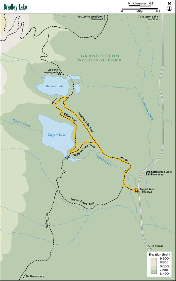
Start: Taggart Lake Trailhead
Total distance: 4.9-mile lollipop loop
Best season: June through Sept
Maps: Earthwalk Press Grand Teton map; National Park Service trail guide to Taggart and Bradley Lakes
Finding the trailhead: Take US 89 north of Jackson for 11.5 miles and turn left (west) at the Moose Junction. Drive past the Moose Visitor Center and through the entrance station (about a mile after turning off the highway). Follow this paved park road for another 2.2 miles from the entrance station and turn left (west) into the Taggart Lake Trailhead. If you’re coming from the north, drive 17.4 miles from the Jackson Lake Junction and turn right (west) into the trailhead parking lot. This trailhead has toilet facilities and plenty of parking. Trailhead GPS: 43.693164 / -110.732919
The Hike
Bradley Lake, like Taggart Lake, was named for a member of the 1872 Hayden Expedition and, like Taggart Lake, is one of the most accessible and popular short day hikes in the park.
The first 0.2 mile of the Taggart Lake Trail to the first junction is double wide and flat and goes through a sagebrush-dotted meadow. At the junction, go right (northwest); the trail becomes singletrack and goes past some minor development and on to Taggart Creek, which you cross on a sturdy footbridge. After the creek the trail climbs gradually up to the top of a moraine, where you get consistently good views of the Teton Range, including Grand Teton. This section of the trail also goes through a 1996 forest-fire burn, so you can observe how the forest regenerates itself.
Hard to beat the view from Bradley Lake. National Park Service
You see the Bradley Lake Trail 1.1 miles from the trailhead. Turn right (north) here and continue through 0.9 mile of the same terrain to 7,022-foot Bradley Lake, a deep pool at the foot of Garnet Canyon, impounded there long ago when the glacier flowing out of the canyon melted. At this point you can retrace your steps to the trailhead, but you can also add about a mile to make a loop and see two lakes instead of one. If you prefer the loop option, take a left (south) on the Valley Trail connecting Bradley and Taggart Lakes and climb over a short but steep ridge (actually another moraine) between the lakes.
It’s only 1.3 miles to forest-lined Taggart Lake, which is at a slightly lower elevation (6,902 feet) but otherwise similar to Bradley Lake. I liked the view from Taggart better than from Bradley, but they are both beautiful mountain lakes.
Before you reach the footbridge over the outlet of Taggart Lake, turn left (east) on the Taggart Lake Trail and follow it for 0.5 mile back to the junction with the Bradley Lake Trail. From here, retrace your steps back to the trailhead.
Camping: Bradley Lake has one designated campsite, but it’s reserved for backpackers taking the Grand Teton Loop and not available for overnighters.
Options: You can take the loop in reverse with no increase in difficulty. You can also take the out-and-back option, or you can add another 0.5 mile to the hike by following the Valley Trail south past Taggart Lake to the junction with the Beaver Creek Trail. Turn left (east) here and follow the trail back to the Taggart Lake Trailhead.
Miles and Directions
0.0Taggart Lake Trailhead
0.2Start of loop trail; turn right
0.4Taggart Creek
1.1Junction with Bradley Lake Trail; turn right
2.0Bradley Lake and junction with Valley Trail; turn left
3.3Taggart Lake and junction with Taggart Lake Trail; turn left
3.8Junction with Bradley Lake Trail; turn right
4.7Junction with loop trail; turn left
4.9Taggart Lake Trailhead