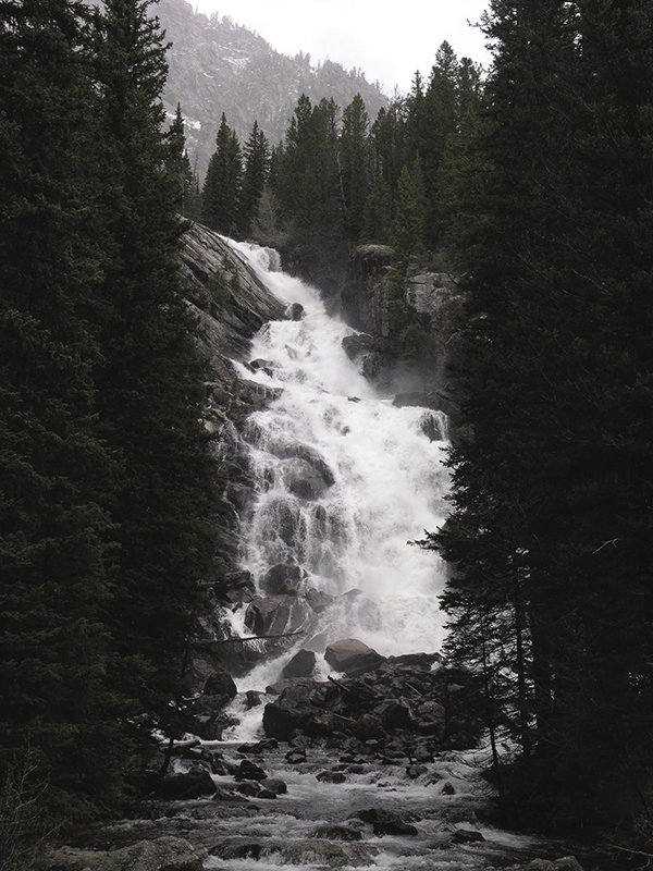
Hidden Falls on the Jenny Lake loop hike. National Park Service
16 Jenny Lake
Description: A loop hike around the shoreline of a centerpiece of Grand Teton National Park
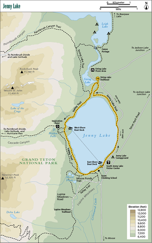
Start: String Lake Trailhead
Total distance: 7.7-mile loop
Best season: June through Sept
Maps: Earthwalk Press Grand Teton map; National Park Service handout map
Finding the trailhead: Take US 89 north of Jackson for 11.5 miles and turn left (west) at the Moose Junction. Drive past the Moose Visitor Center and through the entrance station (about a mile after turning off the highway). Follow this paved park road for another 9.7 miles from the entrance station to the Jenny Lake turnoff. Turn left (west) here and drive 0.6 mile (follow the signs and take two right turns) to the String Lake Trailhead and Picnic Area. If you’re coming from the north, drive 9.9 miles from the Jackson Lake Junction and turn right (west) at the Jenny Lake turnoff. If you plan to start at South Jenny Lake, go to the South Jenny Lake turnoff, which is 2.9 miles south of the Jenny Lake turnoff on the main park road. Park in one of the large parking lots at the trailhead or the picnic area. There are no toilet facilities right at the trailhead, but you can find them at the nearby picnic area. The South Jenny Lake area has a general store, visitor center, boat dock, toilet facilities, and plenty of room to park. Trailhead GPS: 43.784082 / -110.727354
The Hike
There aren’t many hikes of this distance that follow the shoreline of a beautiful lake most of the way. This makes the Jenny Lake loop hike one of the most popular in the park.
You can start at either South Jenny Lake or the String Lake Trailhead at the north end of Jenny Lake. This trail description follows the counterclockwise route starting from the String Lake Trailhead. This allows you to hike the more remote west side of the lake in the morning hours, stop for a snack at the South Jenny Lake general store, visit a visitor center without driving to it, and enjoy a scenic walk along the more developed, but more scenic, east shore after lunch.
The trail starts about 100 yards south of the trailhead parking lot at the bridge over the stream leaving String Lake. Go right (west) here and cross the bridge. In 0.2 mile you turn left (south) onto the Valley Trail at the junction with the String Lake Trail.
Hidden Falls on the Jenny Lake loop hike. National Park Service
After this junction, hike along the stream between String Lake and Jenny Lake for about a quarter mile until you get your first view of Jenny Lake at the inlet. From here the trail follows the lakeshore until you get near the boat dock area on the west side of the lake. You might not see many hikers on the trail to the boat dock, but expect to see lots of people in the dock area because the boat ride across Jenny Lake is very popular. Many park visitors take the boat over to see Hidden Falls and Inspiration Point.
As you approach the boat dock area, the trail veers away from the lake slightly. At this point, you can take a short spur trail down to see the dock and the lake and the 0.8-mile round-trip up to see Hidden Falls and to marvel at the view from Inspiration Point.
After being inspired on Inspiration Point, go back to the main trail and continue along the lake to the South Jenny Lake area. The west-side trail gets rocky in a few places but is mostly flat and uncrowded. The trail closely follows the lakeshore after the boat dock area, but gradually pulls away from the lake as you reach the junction with the Moose Ponds Trail. Go left (south) at this junction. The developed southern section of Jenny Lake can get confusing, but stay on the trail near the lake, and you eventually come to the visitor center area. You pass by the Jenny Lake boat launch, a vehicle campground, other buildings and developments, and then over a long footbridge over the outlet of Jenny Lake and on to the visitor center area. This is slightly more than halfway through the hike, so it’s a good time to lie back, get a snack at the general store, and check out the interpretive displays in the visitor center before continuing up the east shore of the lake.
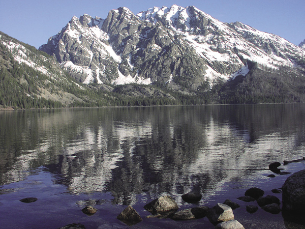
Jenny Lake from the east-shore trail. National Park Service
The trail through the developed area is paved, but the pavement ends about a quarter mile up the lakeshore. The trail on the east shore is more heavily used and in better shape than on the west shore, and the one-way scenic drive parallels the trail for part of the way. Most hikers would agree that the scenery is also better on the east shore, where you can enjoy classic views of the high peaks across the lake.
Camping: No camping allowed on this route.
Options: This loop hike can be taken in either direction. You can also make this a 4.6-mile shuttle and skip the developed east side of the lake by leaving a vehicle at one end and hiking only the more remote west side of the lake to see Hidden Falls.
Side trips: Don’t miss the 0.4-mile side trip up to Hidden Falls. Keep going up to Inspiration Point (another 0.4 mile) for a panoramic view of Jenny Lake.
Miles and Directions
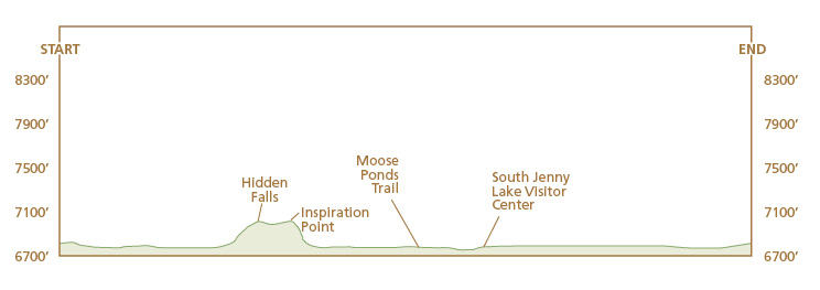
0.0String Lake Trailhead
0.1Bridge over outlet of String Lake
0.3Valley Trail to Jenny Lake inlet; turn left
2.2West-shore boat dock and spur trail to Hidden Falls/Inspiration Point
4.0Junction with Moose Ponds Trail; turn left
4.3Boat-launching area
4.5Bridge over outlet of Jenny Lake
4.6South Jenny Lake Boat Dock/Visitor Center; start of paved trail
4.8End of paved trail
7.7String Lake Trailhead