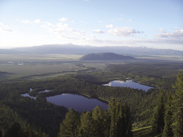
Bradley and Taggart Lakes, two high points of the Valley Trail. National Park Service
20 Valley Trail
Description: A forested, low-country day hike or overnighter to three lakes
Start: Lupine Meadows Trailhead
Total distance: 14.9-mile shuttle
Best season: July through Sept
Maps: Earthwalk Press Grand Teton map; National Park Service handout map; park service trail guide to Taggart and Bradley Lakes
Finding the trailhead: Take US 89 north of Jackson for 11.5 miles and turn left (west) at the Moose Junction. Drive past the Moose Visitor Center and through the entrance station (about a mile after turning off the highway). Follow this paved park road for another 6.6 miles from the entrance station and turn left (west) onto a gravel road at the Lupine Meadows turnoff. Follow this road for 1.4 miles until it ends at the trailhead parking lot. From the north, drive 21.8 miles from the Jackson Lake Junction and turn right (west) at the Lupine Meadows turnoff. The trailhead has toilet facilities and a huge parking area, but this trailhead is so popular that it can be full, especially at midday. You can find a general store at the South Jenny Lake turnoff about a mile to the north. Trailhead GPS: 43.734525 / -110.741637
The Hike
This isn’t one of the high-country adventures that most people visualize when they think of Grand Teton National Park. Instead, this is mostly a walk in the woods similar to what you would find in many western mountain ranges. The Valley Trail, which goes to three low-elevation lakes, is a popular choice for early spring because the snow gives up this low-elevation area long before the high canyons and passes.
The trail is in good shape the entire way, with a hill between each lake and canyon. Some sections of the trail, mainly at the south end near Teton Village, receive heavy horse use. The trail goes through a forest mixed with lodgepole, Engelmann spruce, Douglas fir, and aspen. The southern end of the trail has more aspen and turns a wonderful aspen gold in the fall.
From Lupine Meadows, the Valley Trail starts out flat through mature forest with nice views of Grand Teton off to the right. Then it climbs up a ridge to the junction with the Surprise Lake Trail, which also goes to Garnet Canyon. Turn left (south) and drop down to Bradley Lake. After you have hiked most of the way around the small lake, you see the Bradley Lake Trail veering off to the left. Go right (south), staying on the Valley Trail, and hike over another ridge (actually a moraine) to Taggart Lake. Go right (south) at the junction with the Taggart Lake Trail and right (south) again 0.8 mile up the trail at the Beaver Creek Trail junction. Both of these trails go off to the east to the Taggart Lake Trailhead.
From the Beaver Creek Trail junction, it’s 2.9 miles to the junction to the Death Canyon Trailhead. You can’t actually see the trailhead when you get to the junction, but it’s only 0.1 mile to the left (east), in case you need a pit toilet. Continue south by going right at this junction as the trail climbs gradually to a great overlook above Phelps Lake, a fabulous place for a little R&R. It’s another 1.1 miles down to Phelps Lake (take a left at the Death Canyon Trail junction) and, if you’re backpacking, your overnight campsite.
The trail skirts the west side of Phelps Lake (watch for moose; they’re everywhere around Phelps Lake) and then keeps going south through the same terrain. Go left (south) at both junctions with the Open Canyon Trail less than a mile after the lake.
Bradley and Taggart Lakes, two high points of the Valley Trail. National Park Service
When you get to Granite Creek, you see the junction with the trail up Granite Canyon on the north bank of the stream. Go left (south) and cross the sturdy footbridge. Just on the other side of the stream is the junction with the trail to the Granite Canyon Trailhead, 1.6 miles to the left (east). Go right (south) and head for Teton Village. From here to the park boundary, expect to see large horse parties. Parts of this trail are heavily trampled.
After a 1.7-mile hike through aspens and small meadows, you reach the park boundary, where the horse use abruptly ends. From this point on, you go through the Teton Village Ski Area to the main lodge. The trail through the ski area can get very confusing. Follow the signs that say Summer Hiking Trail or Valley Trail to the main ski lodge. You can usually see the main lodge and tram to help stay on the right track.
Camping: Phelps Lake has three excellent campsites. As you approach the lake, watch for a junction with a trail going to the left (east) to the campsites. All three are on the lake’s north shore, with a good view of the lake, fire pits, and room for two tents. Two share a food storage box; one has its own food area and bear box. The campsites are out of sight of the main trail, but they are fairly close. Please talk softly to respect the privacy of others. Bradley Lake also has a designated campsite, but this is reserved for backpackers doing the Grand Teton Loop.
Options: You can shorten this shuttle by leaving a vehicle at the Taggart Lake, Death Canyon, or Granite Canyon Trailheads.
You can take this shuttle in reverse, of course, which means you face the fairly steep climb up through the ski area. When we hiked this route, we started at Teton Village and had a frustrating experience trying to find the trail amid all the construction and roads in the first mile. Hiking from the north, it should be easier to navigate through the ski area because you can look ahead and see the main ski lodge and tram where the trail ends.
The trail goes by five spur trails back to trailheads along the eastern slope of the Teton Range, so you have lots of options for bailing out and cutting this hike short.


Miles and Directions
0.0Lupine Meadows Trailhead
1.7Junction with Surprise Lake Trail; turn left
3.1Bradley Lake
3.3Junction with Bradley Lake Trail; turn right
4.1Taggart Lake
4.2Junction with Taggart Lake Trail; turn right
5.0Junction with Beaver Creek Trail; turn right
7.9Death Canyon Trailhead; turn right
8.7Phelps Lake Overlook
9.5Junction with Death Canyon Trail; turn left
9.8Phelps Lake
10.4First junction with Open Canyon Trail; turn left
10.6Second junction with Open Canyon Trail; turn left
12.3Junction with Granite Canyon Trail; turn left
12.4Junction with trail to Granite Canyon Trailhead; turn right
14.2Park boundary
14.9Teton Village