
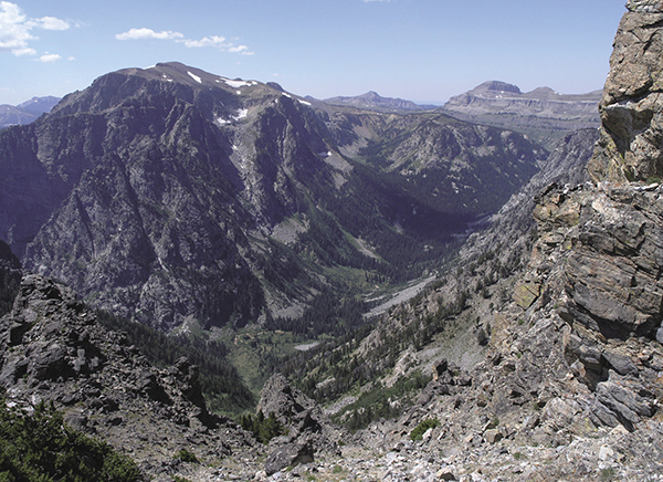
Hiking the Static Peak Divide on the Grand Teton Loop route. National Park Service
22 The Grand Teton Loop
Description: An epic backpacking adventure around the heart of Grand Teton National Park
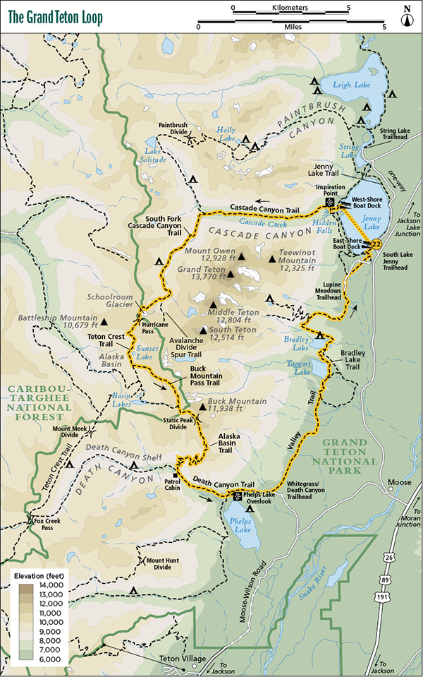
Start: South Jenny Lake Boat Dock and Visitor Center
Total distance: 32.7-mile loop
Best season: Late July through mid-Sept
Maps: Earthwalk Press Grand Teton map; National Park Service handout map
Finding the trailhead: Take US 89 north of Jackson for 11.5 miles and turn left (west) at the Moose Junction. Drive past the Moose Visitor Center and through the entrance station (about a mile after turning off the highway). Follow this paved park road for another 6.8 miles from the entrance station to the South Jenny Lake turnoff. Turn left (west) here and drive less than 0.5 mile to the South Jenny Lake Visitor Center. From the north, drive 12.8 miles from the Jackson Lake Junction and turn right (west) at the South Jenny Lake turnoff. The South Jenny Lake area has a general store, visitor center, boat dock, toilet facilities, and usually plenty of room to park. This is a heavily used area, and the boat ride across the lake is very popular, so in midday during the summer, the parking lot could be full. From the South Jenny Lake Boat Dock, take the short boat ride across the lake to the west-shore boat dock. The boat leaves every fifteen to twenty minutes for a small fee. If you have two vehicles, you can leave one of them at the Lupine Meadows Trailhead (about a mile walk to the south). The turnoff to Lupine Meadows is about a quarter mile south of the South Jenny turnoff on the main park road. Trailhead GPS: 43.751604 / -110.725388
Recommended itinerary:
The Hike
Capturing the true essence of the Teton Range on a day hike can be challenging, but with a night or two in the shadows of the high peaks, it creeps into your insides and takes root. That’s an excellent reason to take this hike.
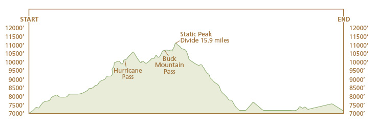
You need at least four days to cover this entire loop and have any extra time for relaxing and for side trips. Even by taking four or five days, though, this is still a tough trip. Because of the position of the camping zones, you’re looking at 10-plus miles on two of the days. This hike description describes a four-day trip, but check the options section below for ways to shorten or lengthen the trip.
The trip starts with a pleasant boat ride across Jenny Lake. You can clearly see the beginning of your route, the mouth of Cascade Canyon, during the fifteen-minute ride. The mouth of Cascade Canyon around Hidden Falls is perhaps the most heavily used spot in the park. Thousands of visitors take the scenic boat ride across Jenny Lake and mill around the falls and Inspiration Point an hour or two and then return. The area shows the wear and tear of this heavy use and it’s easy to see why. The falls are spectacular, and you really can get inspired on Inspiration Point.
Most visitors to Hidden Falls do not take the scenic hike up Cascade Canyon, so once you’ve gone past Inspiration Point, the traffic thins out dramatically. The hike up the canyon climbs seriously for about the first mile and then goes into a gradual, almost unnoticeable ascent along the, of course, cascading stream. Cascade Creek also pauses in some smooth-water sections to give a quiet contrast to the steep canyon walls on each side. Mount Owen and Teewinot Peak dominate the southern horizon. The steep canyon gives you one outstanding view after another all the way to the junction where the trail splits into the South Fork up to Hurricane Pass and the North Fork to Lake Solitude and Paintbrush Divide.
Hiking the Static Peak Divide on the Grand Teton Loop route. National Park Service
Go left (southwest). The grade becomes slightly more precipitous as you head toward Hurricane Pass. Look for a campsite in the early part of the camping zone, which starts shortly after the junction.
Start early enough the next morning to allow time for a side trip up Avalanche Divide. When you get to the junction with Avalanche Divide, hang your packs and take two or three hours enjoying a truly fantastic view of Grand Teton, Middle Teton, and South Teton, the best view of all three I found anywhere in the park. The trail to the divide is steep and gets a little hard to follow near the divide, but the incredible vistas make the pain and exhaustion go away—or at least worth it.
Back at the junction, start the climb up to Hurricane Pass—a gap in The Wall, a steep cliff along the park boundary. It’s a respectable but not brutal climb to the pass. The trail is in great shape and nicely switchbacked. At this point it may give you some comfort to know that doing this hike in reverse would be even more difficult, with over 10 miles of steep upgrade in Death Canyon and up to Static Peak Divide.
On the pass, true to its namesake, it may get a bit breezy (around a Category 3 hurricane when I was there), but hang onto something long enough to get a memorable view of everything. In addition to the incredible mountain scenery, you can see gradually disappearing Schoolroom Glacier right below the pass.
From the pass, it’s a short walk on the ridge before dropping down into Alaska Basin. You could call this the “no wimp zone.” Anything you find up here is hardy—the alpine sunflowers, the little willows that might be one hundred years old, the overstuffed marmots running around, and, of course, even the mighty backpackers who make it to Alaska Basin.
Once over the ridge and into the basin, you get a sweeping view of the entire basin and Battleship Mountain to the west. The trail goes along the west shoreline of Sunset Lake and, shortly thereafter, comes to the first of many junctions. To stay on this route, go left (east), but you may want to go over to the Basin Lakes area for your second night out. In that case, go right (south) and then left (east) at the junction just before the lakes. Both routes take you to Buck Mountain Pass and are about the same length, but the Basin Lakes route involves a slightly tougher climb.
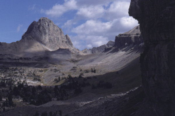
Death Canyon from the trail to Static Peak Divide. National Park Service
When you get to Buck Mountain Pass, you may have the impression that it’s all downhill from here. Wrong. You still have a mild climb ahead of you to get to Static Peak Divide, the third pass on this route.
The trip up Static Peak Divide and the divide itself should get your adrenaline flowing. For a short stretch you hike on a trail gouged out of a steep cliff, so be careful. If you have young children, this would be a good place to keep them on a short leash. Static Peak Divide is quite austere and ruggedly spectacular, but don’t get caught in a lightning storm. Yes, that’s how it earned its name.
From the divide, it’s a nice high-country hike for about a mile, and then you drop into the forested south slope of Death Canyon. The trail switchbacks downward endlessly to the floor of Death Canyon, the junction with the Death Canyon Trail, and a patrol cabin.
Go left (east) and continue your downhill hike on a fairly rocky trail down Death Canyon. You can see Phelps Lake ahead, which will probably be your next campsite. If so, go right (south) at the junction above the lake. About 0.4 mile later as you approach the lake, watch for a spur trail to the left (east) going around to the campsites on the north shore of the lake.
After your stay at Phelps Lake, retrace your steps back up to the Valley Trail above the lake and take a right (north). There is a surprisingly steep hill coming out of Phelps Lake, but this is somewhat indicative of the rest of this last day. As you go from Phelps Lake to Taggart Lake to Bradley Lake to the Lupine Meadows Trailhead, you
Alaska Basin—not part of the park, but it should be. National Park Service
climb a ridge (or a moraine in some cases) between each point—nothing very steep, but constantly up and down.
This last day, hiking along the base of the Teton Range, is quite the contrast to the first three days of the hike spent in the high country. You go through mature forest with a few aspen groves and meadows. Watch for moose, black bears, and other wildlife, especially around Phelps Lake, where I also saw a rare rubber boa on the trail.
About 2 miles after Phelps Lake, go left (north) at the junction with the trail to the Death Canyon Trailhead. Also take left turns at the Beaver Creek, Taggart Lake, and Bradley Lake junctions. Glaciers created these lakes by flowing out of the canyons, melting and leaving a moraine to form a natural dam. The view from Taggart Lake with Grand Teton as a backdrop is another great candidate for a prize-winning postcard. Refer to the Valley Trail, Taggart Lake, and Bradley Lake trail descriptions (hikes 20, 11, and 12, respectively) for more information on this leg of your trip.
After Bradley Lake, you reach the junction with the trail to Garnet Canyon and Surprise and Amphitheater Lakes. Go right (north) and hike the last 1.7 miles to the Lupine Meadows Trailhead. Walk about a mile over to the South Jenny Lake area where you left your vehicle to take the boat ride four days earlier.
Camping: The South Fork Cascade Camping Zone has at least fifteen indicated campsites, but you can camp anywhere in the zone, all the way up to a great site at
the junction with the Avalanche Divide Trail. Most indicated campsites are four-star or five-star with nice views and privacy and good access to water, but shy away from any of the exposed sites if the weather looks ominous. To keep the distance fairly equitable each day of your trip, camp in the lower part of this camping zone.
Alaska Basin is outside of the park in the Jedediah Smith Wilderness, so you can set up a no-trace camp anywhere in the basin. If you camp at Sunset Lake, don’t camp on the shoreline. There are several great campsites safely away from the beautiful but fragile alpine lake.
Phelps Lake has three excellent designated campsites—all of them are on the north shore of the lake with fire pits and room for two tents. Two share a food storage box; one has its own. The campsites are out of sight of the main trail, but they are fairly close, so please talk softly to respect the privacy of others.
There is no camping between Alaska Basin and Phelps Lake (11 miles) and between Phelps Lake and the Lupine Meadows Trailhead (10 miles). There is, however, one designated campsite at Bradley Lake, which the NPS reserves for hikers taking this or similar long backpacking trips through this section of the park. You can stay there and split the route from Phelps Lake to the trailhead into two days.
Options: I have never hiked up from Death Canyon to the Static Peak Divide, but while hiking down it I was left with the impression that I didn’t want to do this trip in reverse, especially with a loaded backpack.
You have the option of shortening your trip by leaving vehicles at the Death Canyon or Taggart Lake Trailheads. You could lengthen your trip by one day by spending a night on the Death Canyon Shelf. If this interests you, keep going south from Basin Lakes until you find one of many five-star campsites on the shelf. Then, the next morning, go back to Alaska Basin and on to Buck Mountain Pass and the rest of the trip.
If the Phelps Lake campsites are taken, you can camp in the Death Canyon Camping Zone above the patrol cabin at the junction of the trail to Static Peak Divide. This adds 2 to 3 miles to the trip and would leave a very long last day if you go all the way to Lupine Meadows, but you can also spend a night at the Bradley Lake campsite reserved just for hikers doing long backpacking trips.
It’s difficult to get the spacing correct on the last section of this trip, and it’s easy to end up with more miles in one day than you really want. One option is to hang packs somewhere near the Death Canyon Trailhead and walk the rest of the trip with a daypack. If you do this, be sure to hang your packs out of reach of bears. Then, after reaching the Lupine Meadows Trailhead, drive back to the Death Canyon Trailhead for your overnight packs.
Side trips: You’ll really miss something if you don’t do the side trip up to Avalanche Divide, but it’s a difficult climb to get there, making it an option for the fit and energetic only. If you have extra time after setting up camp in Alaska Basin, there are several short trails for other interesting side trips. In addition the basin is open, subalpine country, which makes off-trail hiking easy.
Miles and Directions
0.0South Jenny Lake Boat Dock and Visitor Center
0.2Junction with Jenny Lake Trail; go straight onto Cascade Canyon Trail
0.5Hidden Falls and junction with spur trail to Hidden Falls Overlook
0.9Inspiration Point
1.6Horse bypass trail
4.9Junction with South Fork and North Fork Cascade Canyon Trails; turn left
8.4Junction with spur trail to Avalanche Divide; turn right
10.0Hurricane Pass, Schoolroom Glacier, and the park boundary
11.7Sunset Lake
12.0Junction with Buck Mountain Pass Trail; turn left
13.8Junction with Alaska Basin Trail; turn left
14.4Buck Mountain Pass and the park boundary
15.2Static Peak Divide
19.2Junction with Death Canyon Trail; turn left
21.4Junction with spur trail to Phelps Lake (trip to lake not included in mileage)
21.8Phelps Lake Overlook
23.0Junction with trail to Death Canyon Trailhead; turn left
26.7Junction with Beaver Creek Trail; turn left
27.5Taggart Lake
27.6Junction with Taggart Lake Trail; turn left
28.6Bradley Lake
28.7Junction with Bradley Lake Trail; turn left
30.0Junction with Surprise Lake Trail; turn right
31.7Lupine Meadows Trailhead
32.7South Jenny Lake Trailhead