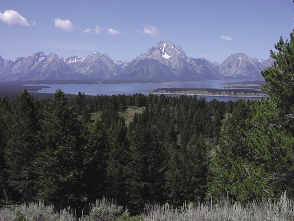
Jackson Lake from Signal Mountain. National Park Service
32 Signal Mountain
Description: The only trail in this section of the park with a unique view of Jackson Hole
Start: Signal Mountain Lodge
Total distance: 7.4-mile double-lollipop loop
Best season: July through Sept
Maps: Earthwalk Press Grand Teton map; National Park Service handout map
Finding the trailhead: Take US 89 north of Jackson for 11.5 miles and turn left (west) at the Moose Junction. Drive past the Moose Visitor Center and through the entrance station (about a mile after turning off the highway). Follow this paved park road for another 17 miles from the entrance station and turn left (west) into the Signal Mountain Lodge area. If you’re coming from the north, drive 2.6 miles from the Jackson Lake Junction and turn right (west) at the Signal Mountain Lodge area.
This trailhead is difficult to find. Actually, it’s at a small sign on the east side of the road about 0.1 mile south of the Signal Mountain Lodge turnoff. There is no place to pull off or park a car right at the trailhead, so it’s easy to miss it. You can also start this hike from the boat launch area, but again, no parking spots. The closest place to park is in the large lot in the lodge area. This adds about 0.4 mile to the total distance of this trip. There are restrooms, a general store, a restaurant, gift shops, a gas station, and a ranger station in the Signal Mountain area. Trailhead GPS: 43.840067 / -110.61595
The Hike
This is the only official hike in this section of the park. From the top of Signal Mountain, you get a panoramic view of the entire valley—Jackson Lake and the Teton Range to the west, and the Oxbow Bend of the Snake River to the north. Yes, you can drive to the top of Signal Mountain on a paved road, but you miss out on a great hike and some exercise if you do.
From the lodge area, carefully walk across the highway to the trail. From here you climb gradually to the junction with the loop trail, which is 0.3 mile after crossing (again, carefully) paved Signal Mountain Road.
When you get to the start of the loop trail, you can take a left (northeast) on the ridge route or a right on the lake route. It makes no difference, but this trail description takes the clockwise route. This loop does not show on commercial maps for the area, but it is on the NPS handout map.
Jackson Lake from Signal Mountain. National Park Service
The ridge route goes through mature forest and large sagebrush meadows. When you get halfway around the loop, you see the spur trail going off to your left to the top of the mountain. You could skip the 1-mile extension up to the top of Signal Mountain, but you’d be missing the best part of the hike. The view from the top is so much more rewarding when you walk up there.
After you rejoin the loop trail, go left (south) and continue through a big meadow until you drop down to the more forested area around Keith Lake (watch for many species of waterfowl on the lake) and then back to the start of the loop. Go left (west) here and retrace your steps back to the lodge area. The trail is in great shape and easy to follow the entire way.
Commercial maps and the NPS handout show a trail going from the top of the ridge north to Oxbow Bend, but this trail has been abandoned because of the unsafe condition of the old bridge over the Snake River.
Camping: No camping allowed on this route.
Option: If you don’t like hills, you can, of course, get a ride to the top and walk down to the lodge.

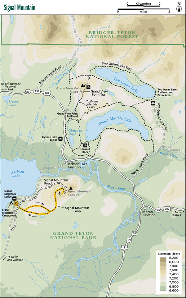
Miles and Directions (from Signal Mountain Lodge)
0.0Signal Mountain Lodge
0.2Trailhead on main park road
0.4Signal Mountain Road
0.7Start of loop trail; turn left
3.2Spur trail to top of Signal Mountain; turn left
3.7Summit of Signal Mountain; turn around and retrace your steps to the loop section of the route
4.2Loop trail; turn left
6.7End of loop; turn left
7.0Signal Mountain Road
7.2Trailhead on main park road
7.4Signal Mountain Lodge